Barnegat (CDP), New Jersey

Last updated

Barnegat, New Jersey
Barnegat cdp nj 029.png
Map of Barnegat CDP in Ocean County. Inset: Location of Ocean County in New Jersey.
Location map of Ocean County, New Jersey.svg
Red pog.svg
Barnegat CDP
Location in Ocean County
USA New Jersey relief location map.svg
Red pog.svg
Barnegat CDP
Location in New Jersey
Usa edcp relief location map.png
Red pog.svg
Barnegat CDP
Location in the United States
Coordinates: 39°45′14″N74°13′18″W / 39.753903°N 74.221654°W / 39.753903; -74.221654
Country Flag of the United States.svg  United States
State Flag of New Jersey.svg  New Jersey
County Ocean
Township Barnegat
Area
[1]
  Total2.71 sq mi (7.02 km2)
  Land2.70 sq mi (6.99 km2)
  Water0.01 sq mi (0.03 km2)  0.47%
Elevation
[2]
33 ft (10 m)
Population
 (2020) [3] [4]
  Total3,894
  Density1,443.83/sq mi (557.38/km2)
Time zone UTC−05:00 (Eastern (EST))
  Summer (DST) UTC−04:00 (Eastern (EDT))
ZIP Code
08005 [5]
Area code 609
FIPS code 3403040 [6] [7] [8]
GNIS feature ID2389174 [6] [9]

Barnegat is an unincorporated community and census-designated place (CDP) [10] located within Barnegat Township, in Ocean County, in the U.S. state of New Jersey. [11] [12] [13] As of the 2010 United States census, the CDP's population was 2,817. [14]

Contents

Geography

According to the United States Census Bureau, the CDP had a total area of 2.667 square miles (6.908 km2), including 2.655 square miles (6.875 km2) of land and 0.012 square miles (0.032 km2) of water (0.47%). [6] [15]

Demographics

Historical population
CensusPop.Note
1990 1,160
2000 1,69045.7%
2010 2,81766.7%
2020 3,89438.2%
Sources: 1990-2010 [13] 2000 [16] 2010 [14]

2010 census

The 2010 United States census counted 2,817 people, 1,019 households, and 733 families in the CDP. The population density was 1,061.2 per square mile (409.7/km2). There were 1,132 housing units at an average density of 426.4 per square mile (164.6/km2). The racial makeup was 92.26% (2,599) White, 2.63% (74) Black or African American, 0.00% (0) Native American, 2.24% (63) Asian, 0.04% (1) Pacific Islander, 0.85% (24) from other races, and 1.99% (56) from two or more races. Hispanic or Latino of any race were 5.79% (163) of the population. [14]

Of the 1,019 households, 37.7% had children under the age of 18; 55.3% were married couples living together; 12.1% had a female householder with no husband present and 28.1% were non-families. Of all households, 21.0% were made up of individuals and 4.8% had someone living alone who was 65 years of age or older. The average household size was 2.76 and the average family size was 3.26. [14]

26.9% of the population were under the age of 18, 9.7% from 18 to 24, 27.6% from 25 to 44, 27.2% from 45 to 64, and 8.7% who were 65 years of age or older. The median age was 35.8 years. For every 100 females, the population had 98.5 males. For every 100 females ages 18 and older there were 98.6 males. [14]

2000 census

As of the 2000 United States census [7] there were 1,690 people, 595 households, and 443 families living in the CDP. The population density was 243.5/km2 (631.1/mi2). There were 640 housing units at an average density of 92.2/km2 (239.0/mi2). The racial makeup of the CDP was 95.68% White, 0.53% African American, 0.12% Native American, 1.30% Asian, 0.65% from other races, and 1.72% from two or more races. Hispanic or Latino of any race were 2.72% of the population. [16]

There were 595 households, out of which 39.7% had children under the age of 18 living with them, 61.2% were married couples living together, 9.2% had a female householder with no husband present, and 25.5% were non-families. 18.8% of all households were made up of individuals, and 8.2% had someone living alone who was 65 years of age or older. The average household size was 2.84 and the average family size was 3.31. [16]

In the CDP the population was spread out, with 29.2% under the age of 18, 7.3% from 18 to 24, 29.9% from 25 to 44, 24.3% from 45 to 64, and 9.3% who were 65 years of age or older. The median age was 37 years. For every 100 females, there were 105.8 males. For every 100 females age 18 and over, there were 101.5 males. [16]

The median income for a household in the CDP was $55,040, and the median income for a family was $59,100. Males had a median income of $36,755 versus $24,500 for females. The per capita income for the CDP was $21,431. About 2.6% of families and 6.0% of the population were below the poverty line, including 6.4% of those under age 18 and 5.9% of those age 65 or over. [16]

Related Research Articles

<span class="mw-page-title-main">Ramblewood, New Jersey</span> Populated place in Burlington County, New Jersey, US

Ramblewood is an unincorporated community and census-designated place (CDP) located within Mount Laurel Township in Burlington County, in the U.S. state of New Jersey. As of the 2010 United States Census, the CDP's population was 5,907.

<span class="mw-page-title-main">Brownville, New Jersey</span> Populated place in Middlesex County, New Jersey, US

Brownville is an unincorporated community and census-designated place (CDP) located within Old Bridge Township, in Middlesex County, in the U.S. state of New Jersey. As of the 2010 United States Census, the CDP's population was 2,383.

<span class="mw-page-title-main">Concordia, New Jersey</span> Populated place in Middlesex County, New Jersey, US

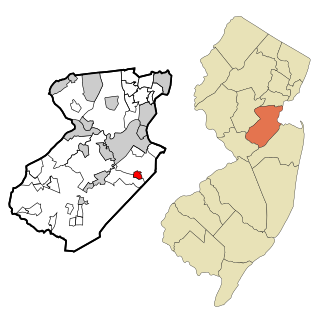
Concordia is an unincorporated community and census-designated place (CDP) located within Monroe Township, in Middlesex County, in the U.S. state of New Jersey. The CDP is oriented around the age restricted gated community of Concordia. As of the 2010 United States Census, the CDP's population was 3,092.

<span class="mw-page-title-main">Cranbury (CDP), New Jersey</span> Populated place in Middlesex County, New Jersey, US

Cranbury is an unincorporated community and census-designated place (CDP) located within Cranbury Township, in Middlesex County, in the U.S. state of New Jersey. As of the 2010 United States Census, the CDP's population was 2,181. Despite the similarity in the name of Cranbury Township and the CDP, the two are not one and the same, as had been the case for most paired Township / CDP combinations prior to the 2010 Census, in which the CDP was coextensive with a township of the same name.

<span class="mw-page-title-main">Heathcote, New Jersey</span> Populated place in Middlesex County, New Jersey, US

Heathcote is an unincorporated community and census-designated place (CDP) located within South Brunswick Township, in Middlesex County, in the U.S. state of New Jersey. As of the 2010 United States Census, the CDP's population was 5,821.

<span class="mw-page-title-main">Whittingham, New Jersey</span> Populated place in Middlesex County, New Jersey, US

Whittingham, also known as Greenbriar at Whittingham, is an unincorporated community and census-designated place (CDP) located within Monroe Township, in Middlesex County, in the U.S. state of New Jersey. As of the 2010 United States Census, the CDP's population was 2,476. The area is focused around the age-restricted gated community of Whittingham.

<span class="mw-page-title-main">Strathmore, New Jersey</span> Populated place in Monmouth County, New Jersey, US

Strathmore is an unincorporated community and census-designated place (CDP) within Aberdeen Township, in Monmouth County, in the U.S. state of New Jersey. At the 2010 census, the CDP's population was 7,258.

<span class="mw-page-title-main">Cedar Glen Lakes, New Jersey</span> Populated place in Ocean County, New Jersey, US

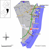
Cedar Glen Lakes is an unincorporated community and census-designated place (CDP) located within Manchester Township, in Ocean County, in the U.S. state of New Jersey. As of the 2010 United States Census, the CDP's population was 1,421.

<span class="mw-page-title-main">Crestwood Village, New Jersey</span> Populated place in Ocean County, New Jersey, US

Crestwood Village is an unincorporated community and census-designated place (CDP) located within Manchester Township, in Ocean County, in the U.S. state of New Jersey. As of the 2010 United States Census, the CDP's population was 7,907.

<span class="mw-page-title-main">Dover Beaches North, New Jersey</span> Populated place in Ocean County, New Jersey, US

Dover Beaches North is an unincorporated community and census-designated place (CDP) located within Toms River, in Ocean County, in the U.S. state of New Jersey. As of the 2010 United States Census, the CDP's population was 1,239. The CDP includes the communities of Ocean Beaches 1, 2 and 3, Chadwick Beach, Chadwick Island, Seacrest Beach, Monterey Beach, Silver Beach, Normandy Shores and half of Normandy Beach. Dover Beaches North is situated on the Barnegat Peninsula, a long, narrow barrier peninsula that separates Barnegat Bay from the Atlantic Ocean.

<span class="mw-page-title-main">Dover Beaches South, New Jersey</span> Populated place in Ocean County, New Jersey, US

Dover Beaches South, more commonly known as Ortley Beach, is an unincorporated community and census-designated place (CDP) located within Toms River, in Ocean County, in the U.S. state of New Jersey. As of the 2010 United States Census, the CDP's population was 1,209. Dover Beaches South is situated on the Barnegat Peninsula, a long, narrow barrier peninsula that separates Barnegat Bay from the Atlantic Ocean.

<span class="mw-page-title-main">Forked River, New Jersey</span> Place in Ocean County, New Jersey, United States

Forked River is an unincorporated community and census-designated place (CDP) located within Lacey Township, in Ocean County, in the U.S. state of New Jersey. As of the 2020 United States census, the CDP's population was 5,274, an increase of 30 (+0.6%) from the 5,244 enumerated at the 2010 census, which in turn reflected an increase of 330 (+6.7%) from the 4.914 counted in the 2000 census.

<span class="mw-page-title-main">Holiday City South, New Jersey</span> Populated place in Ocean County, New Jersey, US

Holiday City South is an unincorporated community and census-designated place (CDP) located within Berkeley Township, in Ocean County, in the U.S. state of New Jersey. As of the 2010 United States Census, the CDP's population was 3,689.

<span class="mw-page-title-main">Leisure Knoll, New Jersey</span> Populated place in Ocean County, New Jersey, US

Leisure Knoll is an unincorporated community and census-designated place (CDP) located within Manchester Township, in Ocean County, in the U.S. state of New Jersey. As of the 2010 United States Census, the CDP's population was 2,490.

<span class="mw-page-title-main">Leisure Village East, New Jersey</span> Populated place in Ocean County, New Jersey, US

Leisure Village East is an unincorporated community and census-designated place (CDP) located within Lakewood Township, in Ocean County, in the U.S. state of New Jersey. As of the 2010 United States Census, the CDP's population was 4,217. Leisure Village East is one of several active adult communities bearing similar names. Leisure Village and Leisure Village West are the other two communities nearby.

<span class="mw-page-title-main">Manahawkin, New Jersey</span> Populated place in Ocean County, New Jersey, US

Manahawkin is an unincorporated community and census-designated place (CDP) located within Stafford Township, in Ocean County, in the U.S. state of New Jersey. As of the 2010 United States Census, the CDP's population was 2,303. Manahawkin has been thought to be a Lenape word meaning "land of good corn", although this has been disputed by recent scholars claiming that it translates to "fertile land sloping into the water."

<span class="mw-page-title-main">North Beach Haven, New Jersey</span> Populated place in Ocean County, New Jersey, US

North Beach Haven is an unincorporated community and census-designated place (CDP) constituting a part of the Jersey Shore community of Long Beach Township, in southern Ocean County, in the U.S. state of New Jersey. The CDP is situated on Long Beach Island, a barrier island separating Barnegat Bay from the Atlantic Ocean.

<span class="mw-page-title-main">Ocean Acres, New Jersey</span> Populated place in Ocean County, New Jersey, US

Ocean Acres is an unincorporated community and census-designated place (CDP) split between Barnegat Township and Stafford Township, in Ocean County, in the U.S. state of New Jersey. As of the 2010 United States Census, the CDP's population was 16,142, of which 925 were in Barnegat Township and 15,217 were in Stafford Township. Ocean Acres is located in the northwestern end of Stafford Township and part of Barnegat Township, and is the newest and biggest part of both communities, with approximately 5,500 lots in an area of 6 square miles (16 km2).

<span class="mw-page-title-main">Silver Ridge, New Jersey</span> Populated place in Ocean County, New Jersey, US

Silver Ridge is an unincorporated community and census-designated place (CDP) located within Berkeley Township, in Ocean County, in the U.S. state of New Jersey. As of the 2010 United States Census, the CDP's population was 1,133.

<span class="mw-page-title-main">Toms River (CDP), New Jersey</span> Populated place in Ocean County, New Jersey, US

Toms River is an unincorporated community and census-designated place (CDP) located within and constituting the mainland portion of Toms River Township, in Ocean County, in the U.S. state of New Jersey. As of the 2020 United States census, the CDP's population was 92,830, its highest decennial count ever and an increase of 4,039 (+4.5%) from the 88,791 recorded at the 2010 census, which in turn reflected an increase of 2,464 (+2.9%) from the 86,327 counted in the 2000 census. The Toms River CDP is the county seat of Ocean County. The area is named for Toms River, whose estuary flows through the community and empties into Barnegat Bay.

References

  1. "ArcGIS REST Services Directory". United States Census Bureau. Retrieved September 20, 2022.
  2. U.S. Geological Survey Geographic Names Information System: Barnegat Census Designated Place, Geographic Names Information System. Accessed August 12, 2012.
  3. Census Data Explorer: Barnegat CDP; New Jersey, United States Census Bureau. Accessed June 16, 2023.
  4. P1. Population by Race and Hispanic or Latino Origin Census Designated Places Source: U.S. Census Bureau, 2020 Census P.L. 94-171 Redistricting Data, New Jersey Department of Labor and Workforce Development. Accessed June 15, 2023.
  5. Look Up a ZIP Code for Barnegat, NJ, United States Postal Service. Accessed August 15, 2012.
  6. 1 2 3 Gazetteer of New Jersey Places, United States Census Bureau. Accessed July 21, 2016.
  7. 1 2 U.S. Census website, United States Census Bureau. Accessed September 4, 2014.
  8. Geographic Codes Lookup for New Jersey, Missouri Census Data Center. Accessed June 9, 2023.
  9. US Board on Geographic Names, United States Geological Survey. Accessed September 4, 2014.
  10. State of New Jersey Census Designated Places - BVP20 - Data as of January 1, 2020, United States Census Bureau. Accessed December 1, 2022.
  11. GCT-PH1 - Population, Housing Units, Area, and Density: 2010 - County -- County Subdivision and Place from the 2010 Census Summary File 1 for Ocean County, New Jersey Archived 2020-02-12 at archive.today , United States Census Bureau. Accessed January 4, 2013.
  12. 2006-2010 American Community Survey Geography for New Jersey, United States Census Bureau. Accessed January 4, 2013.
  13. 1 2 New Jersey: 2010 - Population and Housing Unit Counts - 2010 Census of Population and Housing (CPH-2-32), United States Census Bureau, August 2012. Accessed January 4, 2013.
  14. 1 2 3 4 5 DP-1 - Profile of General Population and Housing Characteristics: 2010 Demographic Profile Data for Barnegat CDP, New Jersey Archived 2020-02-12 at archive.today , United States Census Bureau. Accessed January 5, 2013.
  15. US Gazetteer files: 2010, 2000, and 1990, United States Census Bureau. Accessed September 4, 2014.
  16. 1 2 3 4 5 DP-1 - Profile of General Demographic Characteristics: 2000 from the Census 2000 Summary File 1 (SF 1) 100-Percent Data for Barnegat CDP, New Jersey Archived 2020-02-12 at archive.today , United States Census Bureau. Accessed January 5, 2013.