Bartlett, Texas | |
---|---|
Coordinates: 30°47′44″N97°25′50″W / 30.79556°N 97.43056°W | |
Country | United States |
State | Texas |
Counties | Williamson, Bell |
Area | |
• Total | 1.24 sq mi (3.21 km2) |
• Land | 1.24 sq mi (3.20 km2) |
• Water | 0.00 sq mi (0.01 km2) |
Elevation | 597 ft (182 m) |
Population (2020) | |
• Total | 1,633 |
• Density | 1,421.18/sq mi (548.52/km2) |
Time zone | UTC-6 (Central (CST)) |
• Summer (DST) | UTC-5 (CDT) |
ZIP code | 76511 |
Area code | 254 |
FIPS code | 48-05732 [2] |
GNIS feature ID | 1351556 [3] |
Website | bartlett-tx |
Bartlett is a city in Bell and Williamson counties in the U.S. state of Texas. The population was 1,633 at the 2020 census. [4]
Bartlett lies in two counties as well as two metropolitan areas. The Bell County portion of the city is part of the Killeen – Temple – Fort Hood Metropolitan Statistical Area, while the Williamson County portion is part of the Austin – Round Rock Metropolitan Statistical Area. Known for its late nineteenth and early twentieth century architecture, Bartlett was the site for the filming of movies including The Stars Fell on Henrietta and The Newton Boys , as well as the NBC television drama Revolution .
Starting in 1909, Bartlett was the headquarters of the Bartlett-Florence Railway, later the Bartlett Western Railroad, which ran from Bartlett's connection with the Missouri-Kansas-Texas Railroad to the cotton processing center of Florence, Texas. [5] [6] However, that line was abandoned in 1935. [7]
In 1914 and 1915, Bartlett was home to minor league baseball. The Bartlett Bearcats played as members of the Class D level Middle Texas League for two seasons. Baseball Hall of Fame member Ross Youngs played for Bartlett in 1915.[ citation needed ]
Bartlett is located 24 miles (39 km) south of Temple and 50 miles (80 km) northeast of downtown Austin. The city straddles the line between Bell and Williamson counties; the center of the city is mostly in Bell County, but the slight majority of the city's area is in Williamson County.
According to the United States Census Bureau, the city has a total area of 1.2 square miles (3.2 km2), of which 0.004 square miles (0.01 km2), or 0.24%, is water. [8]
The climate in this area is characterized by hot, humid summers and generally mild to cool winters. According to the Köppen Climate Classification system, Bartlett has a humid subtropical climate, abbreviated "Cfa" on climate maps. [9]
Census | Pop. | Note | %± |
---|---|---|---|
1890 | 206 | — | |
1900 | 957 | 364.6% | |
1910 | 1,815 | 89.7% | |
1920 | 1,731 | −4.6% | |
1930 | 1,873 | 8.2% | |
1940 | 1,668 | −10.9% | |
1950 | 1,727 | 3.5% | |
1960 | 1,540 | −10.8% | |
1970 | 1,622 | 5.3% | |
1980 | 1,567 | −3.4% | |
1990 | 1,439 | −8.2% | |
2000 | 1,675 | 16.4% | |
2010 | 1,623 | −3.1% | |
2020 | 1,633 | 0.6% | |
U.S. Decennial Census [10] |
Race | Number | Percentage |
---|---|---|
White (NH) | 584 | 35.76% |
Black or African American (NH) | 154 | 9.43% |
Native American or Alaska Native (NH) | 3 | 0.18% |
Asian (NH) | 9 | 0.55% |
Mixed/Multi-Racial (NH) | 44 | 2.69% |
Hispanic or Latino | 839 | 51.38% |
Total | 1633 |
As of the 2020 United States census, there were 1,633 people, 460 households, and 303 families residing in the city.
At the 2000 census, [2] there were 1,675 people, 571 households and 404 families residing in the city. The population density was 1,373.3 inhabitants per square mile (530.2/km2). There were 638 housing units at an average density of 523.1 per square mile (202.0/km2). The racial makeup of the city was 61.61% White, 17.97% African American, 0.66% Native American, 0.06% Asian, 16.84% from other races, and 2.87% from two or more races. Hispanic or Latino of any race were 33.07% of the population.
There were 571 households, of which 35.0% had children under the age of 18 living with them, 52.0% were married couples living together, 14.5% had a female householder with no husband present, and 29.1% were non-families. 27.3% of all households were made up of individuals, and 16.5% had someone living alone who was 65 years of age or older. The average household size was 2.78 and the average family size was 3.40.
Age distribution was 29.3% under the age of 18, 8.8% from 18 to 24, 23.0% from 25 to 44, 19.9% from 45 to 64, and 18.9% who were 65 years of age or older. The median age was 36 years. For every 100 females, there were 91.2 males. For every 100 females age 18 and over, there were 83.9 males.
The median household income was $26,094, and the median family income was $35,595. Males had a median income of $22,273 versus $21,016 for females. The per capita income for the city was $12,649. About 21.1% of families and 25.6% of the population were below the poverty line, including 29.5% of those under age 18 and 30.3% of those age 65 or over.
Bartlett is served by the Bartlett Independent School District and is home to the Bartlett High School Bulldogs and Lassies.
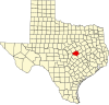
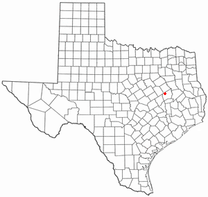
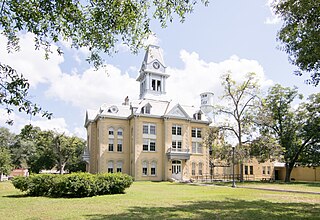
Milam County is a county located in the U.S. state of Texas. As of the 2020 census, its population was 24,754. The county seat is Cameron. The county was created in 1834 as a municipality in Mexico and organized as a county in 1837. Milam County is named for Benjamin Rush Milam, an early settler and a soldier in the Texas Revolution.
Belleair Beach is a city in Pinellas County, Florida, United States. It is part of Tampa–St. Petersburg–Clearwater Metropolitan Statistical Area, more commonly known as the Tampa Bay Area. The population was 1,633 at the 2020 census.
Columbus is the second largest city and county seat of Cherokee County, Kansas, United States. As of the 2020 census, the population of the city was 2,929. It is located approximately 15 miles south-southwest of Pittsburg.
Bellville is a city in the U.S. state of Texas and the seat of Austin County. The city's population was 4,206 at the 2020 census. Bellville is on the eastern edge of the Texas-German belt, and Bellville is known for its German culture and descendants of those Germans still call Bellville home.
Little River-Academy is a city in Bell County, Texas, United States. The population was 1,992 at the 2020 census. It is part of the Killeen–Temple–Fort Hood Metropolitan Statistical Area.
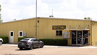
Troy is a city in Bell County, Texas, United States. The population was 2,375 at the 2020 census. It is part of the Killeen–Temple–Fort Hood Metropolitan Statistical Area.
Meridian is a city and the county seat of Bosque County in central Texas, United States. It is forty-seven miles northwest of Waco. The population was 1,396 at the 2020 census.
De Kalb is a city in Bowie County, Texas, United States; it is part of the Texarkana metropolitan statistical area. Its two area codes are 430 and 903. Its ZIP code is 75559. It is in the Central Time Zone, and its population was 1,527 at the 2020 United States census.
Silverton is a city in Briscoe County, Texas, United States. The population was 629 at the 2020 census.
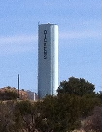
Dickens is a city in and the county seat of Dickens County, Texas, United States. The population was 286 at the 2010 census, down from 332 at the 2000 census.
Fairfield is a city and county seat of Freestone County, Texas, United States. The population was 2,850 at the 2020 census, down from 3,094 at the 2000 census. It was founded in 1851.
Grapeland is a city in Houston County, Texas, United States. Its population was 1,465 as of the 2020 census.
Jewett is a city in Leon County, Texas, United States. The population was 1,167 at the 2010 census. It was laid out in 1871 by the International Railroad Company.
Liberty is a city in the U.S. state of Texas, within Liberty County. The population was 8,279 at the 2020 census. It serves as the seat of Liberty County.
Newton is a city in and the county seat of Newton County, Texas, United States. The population was 1,633 at the 2020 census.
Strawn is a city in Palo Pinto County, Texas, United States. The population was 540 at the 2020 census. Strawn, on State Highway 16 and 108, Farm to Market Road 2372, and the Missouri Pacific Railroad in southwestern Palo Pinto County, was one of several towns developed about 1880 when the Texas and Pacific Railway began service. The site, known earlier as North Fork for its location on Palo Pinto Creek, was laid out on the land of two early ranchers, Stephen Bethel Strawn and James N. Stuart. Stuart built the area's first house in 1875. A community to the west, Russell's Pocket, and one to the east, Davidsonville, were merged to form Strawn.
Friona is a city in Parmer County, Texas, United States. The population was 4,171 at the 2020 census. Friona was established as a small community in 1898 by XIT Ranch, originally called Frio, which is also the word for "cold" in Spanish.
Florence is a city in Williamson County, Texas, United States. The population was 1,171 at the 2020 census. Since 2000, the territorial limits of Florence have grown by 8%. Florence is located approximately 13 miles (21 km) north from Georgetown and 40 miles (64 km) north of Austin in northwestern Williamson County. Florence is part of the Greater Austin metropolitan area.
Granger is a city in Williamson County, Texas, United States. It was incorporated in 1891. The population was 1,183 at the 2020 census.
Liberty Hill is a city in Williamson County, Texas, United States. The population was 3,646 at the 2020 census. Liberty Hill is part of the Greater Austin metropolitan area.