
Assumption Parish is a parish located in the U.S. state of Louisiana. As of the 2010 census, the population was 23,421. Its parish seat is Napoleonville. Assumption Parish was established in 1807, as one of the original parishes of the Territory of Orleans.

Bayou La Batre is a city in Mobile County, Alabama, United States. It is part of the Mobile metropolitan area. As of the 2020 census, the population was 2,204, down from 2,558 at the 2010 census.
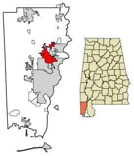
Saraland is a city in Mobile County, Alabama, United States, and a suburb of Mobile. As of the 2020 census, the population of the city was 16,171, up from 13,405 at the 2010 census. Saraland, part of the Mobile metropolitan area, is the third largest city in Mobile County.
Barataria is a census-designated place (CDP) in Jefferson Parish, Louisiana, United States. The population was 1,057 in 2020. It is part of the New Orleans–Metairie–Kenner metropolitan statistical area.
Lafitte is an unincorporated community and census-designated place (CDP) in Jefferson Parish, Louisiana, United States. The population was 972 at the 2010 census, and 816 in 2019. In 2020, its population increased to 1,014 people. It is part of the New Orleans–Metairie–Kenner metropolitan statistical area. Lafitte is located at the southern end of Louisiana Highway 45 along Bayou Barataria, and fishing is a major part of the local economy and culture.
Chackbay is a census-designated place (CDP) in northern Lafourche Parish, Louisiana, United States. The population was 5,177 at the 2010 census, up from 4,018 at the 2000 census. It is part of the Houma–Bayou Cane–Thibodaux Metropolitan Statistical Area.
Cut Off is a census-designated place (CDP) on the Bayou Lafourche in Lafourche Parish, Louisiana, United States. The population was 5,976 at the 2010 census. It is part of the Houma–Bayou Cane–Thibodaux Metropolitan Statistical Area. Cut Off's ZIP code is 70345, the area code is 985 and local telephone prefixes are 325, 632 and 693.
Galliano is an unincorporated community and census-designated place (CDP) on the Bayou Lafourche in Lafourche Parish, Louisiana, United States. As of the 2010 census, the CDP population was 7,676. It is part of the Houma–Bayou Cane–Thibodaux Metropolitan Statistical Area.

Golden Meadow French: Canal Yankee is a town along Bayou Lafourche in Lafourche Parish, Louisiana, United States. The population was 2,101 at the 2010 census. It is part of the Houma–Bayou Cane–Thibodaux Metropolitan Statistical Area. Its main source of revenue is the oil and gas industry. The fishing and seafood industries also have strong economic impacts, with charter fishing, restaurants, and lodging actively serving patrons. The town was once known as a speed trap, but it has since been bypassed by Hwy 3235 and city traffic has been reduced to mostly locals; however, the speed limit is reduced to 50 mph on Hwy 3235 and said highway is still patrolled heavily. As in other places in Louisiana, there is a noticeable presence of Cajun culture, music, and cuisine.

Larose is an unincorporated community and census-designated place (CDP) in Lafourche Parish, Louisiana, United States. The population was 7,400 at the 2010 census. It is part of the Houma–Bayou Cane–Thibodaux Metropolitan Statistical Area.

Raceland is an unincorporated community and census-designated place (CDP) on Bayou Lafourche in Lafourche Parish, Louisiana, United States. The population was 10,193 at the 2010 census. It is part of the Houma–Bayou Cane–Thibodaux Metropolitan Statistical Area.
Ama is a census-designated place (CDP) in St. Charles Parish, Louisiana, United States. Ama is on the West Bank of the Mississippi River, just west of the Jefferson Parish line. The population was 1,290 at the 2020 census.
Boutte is a census-designated place (CDP) in St. Charles Parish, Louisiana, United States. The population was 3,075 at the 2010 census, and 3,054 in 2020.
Hahnville is a census-designated place (CDP) in and the parish seat of St. Charles Parish, Louisiana, United States. The population was 2,792 at the 2000 census and 2,959 in 2020. For information on the origin of Hahnville, see Michael Hahn (1830–1886).
Killona is a census-designated place (CDP) in St. Charles Parish, Louisiana, United States. The population was 724 in 2020.
Luling is a census-designated place (CDP) in St. Charles Parish, Louisiana, United States. The population was 11,512 at the 2000 census and 12,119 at the 2010 census. At the 2020 census, 13,716 people lived in Luling.
Paradis is a census-designated place (CDP) in St. Charles Parish, Louisiana, United States. The population was 1,252 at the 2000 census and 1,242 in 2020.

Des Allemands is an unincorporated community and census-designated place (CDP) in Lafourche and St. Charles parishes in the southeastern part of the U.S. state of Louisiana. The population was 2,179 at the 2020 census. The town, known as the "Catfish Capital of the Universe", is along the Bayou des Allemands, which is the boundary of Lafourche and St. Charles parishes. Lac des Allemands is located northwest of the town. The ZIP code for Des Allemands is 70030.
St. Charles Parish is a parish located in the U.S. state of Louisiana. At the 2020 census, its population was 52,549. The parish seat is Hahnville. The most populous community is Luling.

The St. Charles Parish Public School System is a public school district headquartered in Luling, Louisiana, United States. It serves all of St. Charles Parish.


