
Jefferson County is a county located in the U.S. state of Washington. As of the 2020 census, the population was 32,977. The county seat and only incorporated city is Port Townsend. The county is named for Thomas Jefferson.
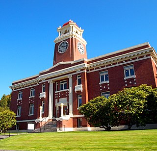
Clallam County is a county in the U.S. state of Washington. As of the 2020 census, the population was 77,155, with an estimated population of 77,805 in 2022. The county seat and largest city is Port Angeles; the county as a whole comprises the Port Angeles, WA Micropolitan Statistical Area. The name is a Klallam word for "the strong people". The county was formed on April 26, 1854. Located on the Olympic Peninsula, it is south from the Strait of Juan de Fuca, which forms the Canada–US border, as British Columbia's Vancouver Island is across the strait.

Carlsborg is an unincorporated community and census-designated place (CDP) in Clallam County, Washington, United States. The population was 995 at the 2010 census, up from 855 at the 2000 census.

Forks, also previously known as the unincorporated town of Quillayute, is a city in southwest Clallam County, Washington, United States. The population was 3,335 at the 2020 census. It is named after the forks in the nearby Bogachiel, Calawah, and Sol Duc rivers which join together to form the Quillayute River.

The Olympic Peninsula is a large arm of land in western Washington that lies across Puget Sound from Seattle, and contains Olympic National Park. It is bounded on the west by the Pacific Ocean, the north by the Strait of Juan de Fuca, and the east by Hood Canal. Cape Alava, the westernmost point in the contiguous United States, and Cape Flattery, the northwesternmost point, are on the peninsula. Comprising about 3,600 square miles (9,300 km2), the Olympic Peninsula contained many of the last unexplored places in the contiguous United States. It remained largely unmapped until Arthur Dodwell and Theodore Rixon mapped most of its topography and timber resources between 1898 and 1900.
Beaver Lake may refer to:

Amanda Park is a census designated place on the Olympic Peninsula in Grays Harbor County, Washington, United States, along U.S. Route 101. Olympic National Park and Lake Quinault are directly to the north. As of the 2010 census the population was 252.

State Route 119 (SR 119) is a 10.93-mile-long (17.59 km) state highway in the U.S. state of Washington, serving Lake Cushman in Mason County within Olympic National Forest. The highway, known locally as Lake Cushman Road, travels northwest into the Olympic Mountains from U.S. Route 101 (US 101) in Hoodsport to Lake Cushman and ends at a gravel road east of the entrance to Olympic National Park on Forest Highway 24 (FFH-24). A gravel road connecting Lake Cushman to the state highway system has existed since the late 1950s and was codified into the current state highway system in 1991, prior to being completely paved by 1999.
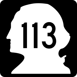
State Route 113 (SR 113), also known as Burnt Mountain Road, is a Washington state highway in Clallam County on the Olympic Peninsula. It connects U.S. Route 101 (US 101) at Sappho to SR 112 near Clallam Bay, traveling north along Beaver Creek and the Pysht River for 10 miles (16 km).

State Route 112 is a state highway and scenic byway in the U.S. state of Washington. It runs east–west for 61 miles (98 km) along the Strait of Juan de Fuca in Clallam County, connecting the Makah Indian Reservation near Neah Bay to U.S. Route 101 (US 101) near Port Angeles.
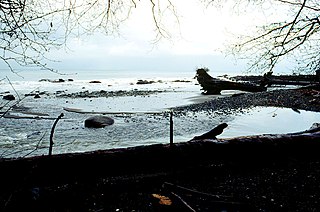
Clallam Bay is an unincorporated community and census-designated place (CDP) in Clallam County, Washington, United States, at the mouth of the Clallam River into Clallam Bay. Known for its natural environment and hunting, Clallam Bay is partially reliant on tourism. Clallam Bay is considered the twin city of nearby Sekiu. As of the 2010 census, the population of Clallam Bay was 363.
Elwha is an unincorporated community in Clallam County, Washington, United States. The community is located along U.S. Route 101 about 9 miles (14 km) from Port Angeles, on the northern edge of the Olympic National Park. The community is located on the Elwha River; where the Elwha Ecosystem Restoration Project took place.

Fairholm is a campground in Clallam County, Washington, United States. The community is located at the west end of Lake Crescent in the Olympic National Park. Fairholm also features a general store, cafe, and other park-related buildings.

Lake Crescent is a deep lake located entirely within Olympic National Park in Clallam County, Washington, United States, approximately 17 miles (27 km) west of Port Angeles on U.S. Route 101 and nearby to the small community of Piedmont. At an official maximum depth of 624 feet (190 m) it is officially the second deepest lake in Washington. A lake-wide bathymetric survey was performed from 2013 to 2014 by Eian Ray and Jeff Engea and the results of this survey showed the maximum depth as being 596 feet. Using GIS statistical analysis, this survey also showed the lake contains approximately 0.5 cubic miles of fresh water.

Sappho is an unincorporated community in Clallam County, Washington, United States. The town is located at the intersection of U.S. Route 101 and State Route 113, in a largely forested area, and features parks and recreational facilities.
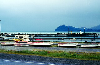
Sekiu is an unincorporated community and census-designated place in Clallam County, Washington, United States. As of the 2010 census it had a population of 27. Overlooking the west side of Clallam Bay and the Strait of Juan de Fuca, it is twinned with the community of Clallam Bay, on the east side of the bay.

The Sol Duc River is a river in the U.S. state of Washington. About 78 miles (126 km) long, it flows west through the northwest part of the Olympic Peninsula, from the Olympic Mountains of Olympic National Park and Olympic National Forest, then through the broad Sol Duc Valley. Near the Pacific Ocean the Sol Duc River joins the Bogachiel River, forming the Quillayute River, which flows about 4 miles (6.4 km) to the Pacific Ocean at La Push. Although the Quillayute River is short, its large tributary rivers—the Sol Duc, Bogachiel, Calawah, and Dickey Rivers—drain the largest watershed of the northern Olympic Peninsula, 629 square miles (1,630 km2). The Sol Duc's watershed is the largest of the Quillayute's tributaries, at 219 square miles (570 km2).

State Route 110 (SR 110) is a 11.10-mile-long (17.86 km) state highway serving Olympic National Park and the Quileute Indian Reservation within Clallam County, located in the U.S. state of Washington. The highway travels west from U.S. Route 101 (US 101) in Forks as La Push Road along the Quileute and Sol Duc rivers to the boundary of Olympic National Park east of La Push. La Push Road was originally added to the state highway system in 1937 as Secondary State Highway 9B (SSH 9B), but was removed in 1955. SR 110 was later established on the route in 1991 after a previous highway with the same designation was removed. A spur route extending west to Mora was originally added with SSH 9B and re-added with SR 110 in 1991.

U.S. Route 101 (US 101) is a United States Numbered Highway that runs along the West Coast from Los Angeles, California to Tumwater, Washington. Within the state of Washington, US 101 connects cities on the coast of the Pacific Ocean and encircles the Olympic Peninsula around the Olympic Mountains. It also serves as the main access for Olympic National Park, several state parks, and other scenic and recreational areas.
Lake Pleasant is a lake located in Clallam County, Washington, United States. The lake is one of the few that are surrounded by private property and is open to fishing all year around. Types of fish at Lake Pleasant are rainbow trout, kokanee, catfish. Salmon spawn in the lake each year. Water activities such as swimming, jet skiing, water skiing are also allowed on the lake year round. The lake is located near the town of Beaver, Washington Between milepost 200 and 202 on U.S. Route 101.


