
The Olympic Peninsula is a large arm of land in western Washington that lies across Puget Sound from Seattle, and contains Olympic National Park. It is bounded on the west by the Pacific Ocean, the north by the Strait of Juan de Fuca, and the east by Hood Canal. Cape Alava, the westernmost point in the contiguous United States, and Cape Flattery, the northwesternmost point, are on the peninsula. Comprising about 3,600 square miles (9,300 km2), the Olympic Peninsula contained many of the last unexplored places in the contiguous United States. It remained largely unmapped until Arthur Dodwell and Theodore Rixon mapped most of its topography and timber resources between 1898 and 1900.

Lake Roosevelt National Recreation Area is a U.S. national recreation area that encompasses the 130-mile (210 km) long Franklin D. Roosevelt Lake between Grand Coulee Dam and Northport, Washington, in eastern Washington state. The Grand Coulee Dam was built on the Columbia River in 1941 as part of the Columbia River Basin project. Lake Roosevelt National Recreation Area is a unit of the National Park Service and provides opportunities for fishing, swimming, canoeing, boating, hunting, camping, and visiting historic Fort Spokane and St. Paul's Mission. Crescent Bay Lake in Grant County just southwest of Lake Roosevelt also falls under the jurisdiction of the National Recreation Area.
Piedmont is a small unincorporated community in Clallam County, Washington, United States. It is located on Lake Crescent in the northwestern corner of the Olympic National Park.

Lake Crescent is a deep lake located entirely within Olympic National Park in Clallam County, Washington, United States, approximately 17 miles (27 km) west of Port Angeles on U.S. Route 101 and nearby to the small community of Piedmont. At an official maximum depth of 624 feet (190 m) it is officially the second deepest lake in Washington. A lake-wide bathymetric survey was performed from 2013 to 2014 by Eian Ray and Jeff Engea and the results of this survey showed the maximum depth as being 596 feet. Using GIS statistical analysis, this survey also showed the lake contains approximately 0.5 cubic miles of fresh water.

Lake Ozette is the largest unaltered natural lake in Washington state at 29.5 km2 (11.4 sq mi).

The Sol Duc River is a river in the U.S. state of Washington. About 78 miles (126 km) long, it flows west through the northwest part of the Olympic Peninsula, from the Olympic Mountains of Olympic National Park and Olympic National Forest, then through the broad Sol Duc Valley. Near the Pacific Ocean the Sol Duc River joins the Bogachiel River, forming the Quillayute River, which flows about 4 miles (6.4 km) to the Pacific Ocean at La Push. Although the Quillayute River is short, its large tributary rivers—the Sol Duc, Bogachiel, Calawah, and Dickey Rivers—drain the largest watershed of the northern Olympic Peninsula, 629 square miles (1,630 km2). The Sol Duc's watershed is the largest of the Quillayute's tributaries, at 219 square miles (570 km2).

The Lyre River in the U.S. state of Washington flows out of Lake Crescent in the Olympic National Park and into the Strait of Juan de Fuca. Originally referred to as "singing waters" by the Indians living near it, the river was first named Rio de Cuesta by Europeans in 1790 by Gonzalo López de Haro, but was later called River Lyre after being charted by Captain Henry Kellett in 1847.

Ferries and steamboats of Lake Crescent, Washington were used for water transport of passengers and freight before highways were built in the area in the early 1920s. Prior to highway construction, Lake Crescent was used as a route from Port Townsend into the northwestern part of the Olympic Peninsula. Ferries, steamboats and similar water craft were built and used on the lake until the Olympic Highway was completed along the south shore of the lake in 1922.

The Storm King Ranger Station, also known as the Storm King Guard Station and Morgenroth Cabin, is a historic building located southeast of Barnes Point, on south shore of Lake Crescent, about 17 miles (27 km) southwest of Port Angeles, Washington. The ranger station is part of the Olympic National Park. The station was added to the National Register of Historic Places in 2007.

This is a list of the National Register of Historic Places listings in Clallam County, Washington.
This is a list of the National Register of Historic Places listings in Olympic National Park.
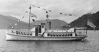
Betty Earles was a small gasoline-powered vessel built in 1913 on Lake Crescent, Washington. The vessel was transferred to Puget Sound in about 1919 and remained in service there until at least 1958.

East Beach was an unincorporated community in Clallam County, Washington, United States. The community is located at the east end of Lake Crescent in the Olympic National Park.
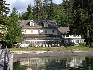
Lake Crescent Lodge, originally called Singer's Lake Crescent Tavern, is a historic resort situated on the shores of Lake Crescent west of Port Angeles, Washington. Located on the Olympic Peninsula within Olympic National Park, the Lodge is owned by the National Park Service and operated by Aramark. The Lodge resort is open seasonally from early May until the end of January with select cabins available during the winter months. Hiking and boating are popular activities for guests, and several peaks, including Mount Storm King and Pyramid Mountain, are easily accessible from the resort. Other hiking opportunities include Marymere Falls, Spruce Railroad, and Barnes Creek Trails.
Mora is a former settlement in Clallam County, in the U.S. state of Washington. The GNIS classified it as a populated place.

Mount Carrie is a 6,995-foot (2,132-metre) mountain summit located within Olympic National Park in Clallam County of Washington state. Mt. Carrie is the highest point in the Bailey Range which is a subrange of the Olympic Mountains. With a good eye and clear weather, the mountain can be seen from the visitor center at Hurricane Ridge. Its nearest higher peak is Mount Mathias (7,156 ft) which is an outlier of Mount Olympus, 6.24 mi (10.04 km) to the south. Due to heavy winter snowfalls, Mount Carrie supports the Carrie Glacier in its northeast cirque, and Fairchild Glacier on the east slope. Precipitation runoff from the mountain drains into tributaries of the Elwha River and Hoh River. There is a scrambling route via the High Divide Trail and Cat Walk.

Mount Lincoln is a 5,868-foot (1,789-meter) mountain summit located in the Olympic Mountains, in Mason County of Washington state. It is situated on the boundary shared by Daniel J. Evans Wilderness and Mount Skokomish Wilderness, as well as the shared common border of Olympic National Park with Olympic National Forest. Lincoln is the second-highest point on Sawtooth Ridge, and the nearest higher neighbor is Mount Cruiser, 1.1 mi (1.8 km) to the northeast. Lincoln has two sub-peaks: a North Peak, and a Southwest Peak. Flapjack Lakes lie immediately west below the north sub-peak. Topographic relief is significant as the summit rises over 5,100 feet (1,600 m) above the Staircase Ranger Station at Lake Cushman in approximately two miles. Precipitation runoff from the mountain drains into tributaries of the North Fork Skokomish River, and partly into Mildred Lakes, thence Hamma Hamma River.

Mount Steel is a 6,225-foot-elevation (1,897-meter) mountain summit located in the Olympic Mountains, in Jefferson County of Washington state. It is situated in Olympic National Park and the Daniel J. Evans Wilderness. The nearest higher neighbor is Mount Duckabush, 1.36 mi (2.19 km) to the southwest. Precipitation runoff from the mountain drains south into tributaries of the North Fork Skokomish River, and north into headwaters of the Duckabush River. Topographic relief is significant as the summit rises over 3,400 feet (1,036 m) above the Duckabush River in approximately one mile.

O'Neil Peak is a 5,758-foot-elevation (1,755-meter) mountain summit located in the Olympic Mountains, in Jefferson County of Washington state. It is situated in Olympic National Park and the Daniel J. Evans Wilderness. The nearest higher neighbor is Mount Duckabush, 1.6 mi (2.6 km) to the east-northeast, and O'Neil Pass lies 1.5-mile to the northeast. Precipitation runoff from the mountain drains into tributaries of the Quinault River. Topographic relief is significant as the summit rises over 4,300 feet (1,310 m) above the Quinault River in approximately 1.5-mile, and 2,700 feet above O'Neil Creek in one-half-mile.


