
Orangeburg County is a county located in the U.S. state of South Carolina. As of the 2020 census, the population was 84,223. Its county seat is Orangeburg. The county was created in 1769.

Beaver County is a county in the Commonwealth of Pennsylvania. As of the 2020 census, the population was 168,215. Its county seat is Beaver, and its largest city is Aliquippa.
Wilkes County is a county located in the U.S. state of North Carolina. It is a part of the state's western mountain region. As of the 2020 census the population was 65,969. Its county seat is Wilkesboro, and its largest town is North Wilkesboro. Wilkes County comprises the North Wilkesboro, NC Micropolitan Statistical Area.

Watauga County is a county located in the U.S. state of North Carolina. As of the 2020 census, the population was 54,086. Its county seat and largest town is Boone. The county is in an exceptionally mountainous region. It is the home of Appalachian State University, which has approximately 20,023 students as of August 20, 2020. Watauga County comprises the Boone, NC Micropolitan Statistical Area.

Stokes County is a county located in the U.S. state of North Carolina. As of the 2020 census, the population was 44,520. Its county seat is Danbury.

Pender County is a county located in the U.S. state of North Carolina. As of the 2020 census, the population was 60,203. Its county seat is Burgaw. Pender County is part of the Wilmington, NC Metropolitan Statistical Area.

Caldwell County is a county in the U.S. state of North Carolina. It is located in the foothills of the Blue Ridge Mountains. As of the 2020 census, the population was 80,652. Its county seat is Lenoir. Caldwell County is part of the Hickory–Lenoir–Morganton, NC Metropolitan Statistical Area.
Ashe County is a county located in the U.S. state of North Carolina. As of the 2020 census, the population was 26,577. Its county seat is Jefferson.

Alleghany County is a county located in the U.S. state of North Carolina. As of the 2020 census, the population was 10,888. Its county seat is Sparta.

The Tennessee River is the largest tributary of the Ohio River. It is approximately 652 miles (1,049 km) long and is located in the southeastern United States in the Tennessee Valley. The river was once popularly known as the Cherokee River, among other names, as the Cherokee people had their homelands along its banks, especially in what are now East Tennessee and northern Alabama. Additionally, its tributary, the Little Tennessee River, flows into it from Western North Carolina and northeastern Georgia, where the river also was bordered by numerous Cherokee towns. Its current name is derived from the Cherokee town, Tanasi, which was located on the Tennessee side of the Appalachian Mountains.
Beaver Creek may refer to:
New River State Park is a North Carolina state park in Ashe County, North Carolina in the United States. Located near Jefferson, North Carolina, it covers 3,323 acres (13.45 km2) in the protected New River watershed. The New River is one of the oldest rivers in the United States. It is considered by some geologists to be possibly one of the oldest rivers in the world, between 10 million and 360 million years old. New River State Park is open for year-round recreation, including canoeing, hiking, picnicking, fishing, camping and environmental education. The park is just off U.S. Route 221 in northwestern North Carolina.

The Cherokee National Forest is a United States National Forest located in the U.S. states of Tennessee and North Carolina that was created on June 14, 1920. The forest is maintained and managed by the United States Forest Service. It encompasses an estimated area of 655,598 acres (2,653.11 km2).
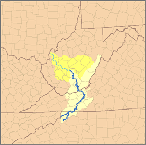
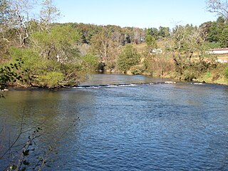
The South Fork New River is a river in the U.S. state of North Carolina.

North Carolina Highway 16 (NC 16) is a 143.8-mile primary state highway in the U.S. state of North Carolina. Traveling in a north–south direction, it connects the cities and towns of Charlotte, Newton, Conover, Taylorsville, Wilkesboro and Jefferson, linking the Charlotte metropolitan area with the mountainous High Country. NC 16 is part of a three-state route 16 that connects the Charlotte region with northwestern West Virginia.

Grassy Creek Township is one of nineteen townships in Ashe County, North Carolina, United States. The township had a population of 455 as of the 2010 census.
Ashe County High School is a public school of secondary education for grades 9–12 located in West Jefferson, North Carolina, US. ACHS is situated in the extreme northwestern portion of the state. It is the only high school in the Ashe County Schools system.
Bina is an unincorporated community in Ashe County, North Carolina, United States. It is located southeast of Lansing on North Carolina Highway 194, along with West Deep Ford Road and McNeil Road.

U.S. Route 19 (US 19) traverses approximately 11.8 miles (19.0 km) across the Tri-Cities area of East Tennessee. The highway begins at Bluff City, where the highway splits into US 19E and US 19W, which both head into North Carolina and rejoin to form US 19 in North Carolina. US 19's Tennessee portion ends at the Virginia state line at the twin cities of Bristol, Tennessee, and Bristol, Virginia.

North Carolina Highway 163 (NC 163) is a primary state highway in the U.S. state of North Carolina. The highway serves as a direct route from West Jefferson towards Wilkesboro.


