Related Research Articles
Notasulga is a town in Lee and Macon counties in the U.S. state of Alabama. As of the 2020 census, the population of the town was 914. The portion in Lee County is part of the Auburn Metropolitan Area. According to the 1910 U.S. Census, it incorporated in 1893. Author Zora Neale Hurston was born in Notasulga in 1891. The town name comes from the Creek words noti sulgi, which means "many teeth".

Mooresboro is a town in Cleveland County, North Carolina, United States. The population was 311 at the 2010 census.

Lowesville is a census-designated place (CDP) in Lincoln County, North Carolina, United States. The population was 2,945 at the 2010 census, up from 1,440 in 2000.

Raynham is a town in Robeson County, North Carolina, United States. The population was 72 at the 2010 census.

Lowrys is a small rural town in Chester County, South Carolina, United States. The population was 200 at the 2010 census.
Leicester is an unincorporated community in Buncombe County, North Carolina United States; although incorporating was proposed in 2007 and an incorporation bill was briefly filed in the North Carolina General Assembly, no measure has been adopted. Leicester is part of the Asheville Metropolitan Statistical Area. As of 2007, Leicester's population is 12,514 people. Since 2000, it has had a population growth of 16.26 percent.
Merry Hill is a rural unincorporated community located in Merry Hill Township in Bertie County in the U.S. state of North Carolina. This area is composed of mostly farm land. Within the town there is one school, Lawrence Academy (Private), which was founded in 1968 and is located on Avoca Farm Road. In the middle of the town is the post office, with the zip code 27957. Avoca Incorporated is a large company, located where the original Avoca Plantation existed, that profits from botanical extraction. Salmon Creek twists and turns through the wooded area of Merry Hill and opens up to the Albemarle Sound. This is known as the Mouth of Salmon Creek. There is currently a golf course called Scotch Hall Preserve in Merry Hill, built in 2009, that overlooks the Mouth of Salmon Creek and reaches out into the Albemarle Sound. The course was designed by retired professional golfer Arnold Palmer.

Bonlee is an unincorporated community in western Chatham County, North Carolina, United States. It is located south of Siler City and north of Bear Creek along Old U.S. Route 421. Bonlee sits at an elevation of 518 feet (158 m). The community is home to several poultry feed mills and a K-8 school. The ZIP Code for Bonlee is 27213.

Currituck is an unincorporated community in extreme northeastern North Carolina, United States. Situated along the Currituck Sound, it serves as the county seat for Currituck County. Currituck is part of the Inner Banks region and is one of the state's few unincorporated county seats. The community harbors the Knotts Island Ferry, which provides free shuttles across the sound to Knotts Island. North Carolina Highway 168 and Courthouse Road are the community's most prominent roads. The Currituck Beach Lighthouse is not located on mainland Currituck but is located across the sound on the Outer Banks.
Ararat is an unincorporated community in the Long Hill Township of Surry County, North Carolina, United States. Ararat is situated on, and is named for, the Ararat River. Ararat is along the former Atlantic & Yadkin Railway line from Mount Airy to Rural Hall that is now operated by the Yadkin Valley Railroad. Landmarks near the center of the community include the community post office, fire department and area churches.
Westfield in an unincorporated community in Surry and Stokes counties in North Carolina, United States. The community itself is located almost entirely within Surry County, with a small portion extending east into Stokes County. The majority of Westfield's Zip Code Tabulation Area is located within Stokes County.
Shoals is an unincorporated community in the Shoals Township of Surry County, North Carolina, United States.
Belews Creek is an unincorporated community in the Belews Creek Township of Forsyth County, North Carolina, United States.

Roaring Gap is an unincorporated community in the Cherry Lane Township of Alleghany County, North Carolina, United States, situated near the border with Wilkes County. Home to three private golf communities, Roaring Gap is a popular summer colony.

Bahama is an unincorporated community in northern Durham County, North Carolina, United States.
Olivia is an unincorporated community centered in the Barbecue Township of Harnett County, North Carolina, United States, but also covering parts of Anderson Creek Township near the Lee County line. It is a part of the Dunn Micropolitan Area, which is also a part of the greater Raleigh–Durham–Cary Combined Statistical Area (CSA) as defined by the United States Census Bureau.
Piney Creek is an unincorporated community located in Piney Creek Township, Alleghany County, North Carolina, United States.
Glade Valley is an unincorporated community located in Alleghany County, North Carolina, United States along U.S. Highway 21 between Cherry Lane and Sparta.
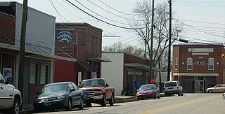
Scottville is an unincorporated community in both Ashe and Alleghany Counties, North Carolina, United States, on U.S. Route 221. It lies at an elevation of 2,861 feet. The ZIP Code for Scottville is 28672.
Cliffside is an unincorporated community and census-designated place (CDP) in southeastern Rutherford County, North Carolina, United States. Its population was 611 as of the 2010 census. Cliffside has a post office with ZIP code 28024. U.S. Route 221 Alternate and North Carolina Highway 120 pass through the community.
References
Powell, William S. (1968), The North Carolina Gazetteer: A Dictionary of Tar Heel Places, Chapel Hill: University of North Carolina Press, ISBN 0-8078-1247-1
36°34′25″N81°23′19″W / 36.5737341°N 81.3887137°W
Municipalities and communities of Ashe County, North Carolina, United States | ||
|---|---|---|
| Towns |  | |
| Unincorporated communities | ||
| Authority control: Geographic |
|---|
memoirs of grassy creek