Bellevue means "beautiful view" in French. It may refer to:

Cameron Parish is a parish in the southwest corner of the U.S. state of Louisiana. As of the 2020 census, the population was 5,617. The parish seat is Cameron. Although it is the largest parish by area in Louisiana, it has the second-smallest population in the state, ahead of only Tensas. Cameron Parish is part of the Lake Charles metropolitan statistical area.

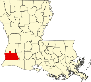
Calcasieu Parish is a parish located on the southwestern border of the U.S. state of Louisiana. As of the 2020 census, the population was 216,785. The parish seat is Lake Charles.

Beauregard Parish is a parish located in the U.S. state of Louisiana. As of the 2020 census, the population was 36,549. The parish seat is DeRidder. The parish was formed on January 1, 1913.

Allen Parish is a parish located in the U.S. state of Louisiana. As of the 2020 census, the population was 22,750. The parish seat is Oberlin and the largest city is Oakdale. Allen Parish is in southwestern Louisiana, southwest of Alexandria.
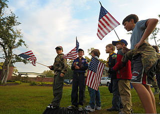
Scouting in Louisiana has a long history, from the 1910s to the present day, serving thousands of youth in programs that suit the environment in which they live.

DeQuincy is the northernmost city in Calcasieu Parish, Louisiana, United States. The population was 3,235 at the 2010 census. DeQuincy is part of the Lake Charles metropolitan statistical area.

Lake Charles is the fifth-largest incorporated city in the U.S. state of Louisiana, and the parish seat of Calcasieu Parish, located on Lake Charles, Prien Lake, and the Calcasieu River. Founded in 1861 in Calcasieu Parish, it is a major industrial, cultural, and educational center in the southwest region of the state. As of the 2020 U.S. census, Lake Charles's population was 84,872.
Moss Bluff is a census-designated place (CDP) in Calcasieu Parish, Louisiana, United States. The population was 12,522 at the 2020 census. Located just north of the city of Lake Charles, it is considered a suburb of that city. Moss Bluff is a burgeoning community, and is one of the communities in Calcasieu Parish besides Lake Charles and Sulphur experiencing growth. Several efforts have been made to incorporate Moss Bluff, but at the present time the community is unincorporated.

Vinton is a town in Calcasieu Parish, Louisiana, United States. The population was 3,400 in 2020. It is part of the Lake Charles metropolitan statistical area.

Westlake is an industrial city in Calcasieu Parish, in western Louisiana, United States, and is part of the Lake Charles metropolitan statistical area. The population was 4,781 in 2020. Westlake was incorporated in 1945. There are many chemical plants and oil refineries situated around the Westlake area.

The Calcasieu River is a river on the Gulf Coast in southwestern Louisiana. Approximately 200 miles (320 km) long, it drains a largely rural area of forests and bayou country, meandering southward to the Gulf of Mexico. The name "Calcasieu" comes from the Indian Atakapa language katkosh, for "eagle", and yok, "to cry".

Louisiana Highway 27 (LA 27) is a state highway located in southwestern Louisiana. It runs 132.42 miles (213.11 km) in a general north–south direction from LA 14 in Holmwood to the junction of U.S. Highways 171 and 190 in DeRidder.

The Lake Charles–Jennings combined statistical area is made up of three parishes in southwestern Louisiana. The statistical area consists of the Lake Charles Metropolitan Statistical Area and the Jennings Micropolitan Statistical Area. The largest principal city is Lake Charles, and the smaller principal city is Jennings. As of the 2010 census, the CSA had a population of 231,201. A July 1, 2019 estimate placed the population at 241,777.
The Church of the Good Shepherd is an historic Episcopal church building located at 715 Kirkman Street in Lake Charles, Calcasieu Parish, Louisiana, United States. Designed by noted Dallas architect C.W. Bulger in the Gothic Revival style of architecture, it was built of stone in 1896.
This is a list of the National Register of Historic Places listings in Calcasieu Parish, Louisiana.
Holmwood is an unincorporated community in Calcasieu Parish, Louisiana, United States. Holmwood is located at the junction of Louisiana highways 14 and 27, 10.8 miles (17.4 km) southeast of Lake Charles.
The 1956 United States presidential election in Louisiana took place on November 6, 1956, as part of the 1956 United States presidential election. State voters chose ten representatives, or electors, to the Electoral College, who voted for president and vice president.
The 1912 United States presidential election in Louisiana took place on November 5, 1912, as part of the 1912 United States presidential election. State voters chose ten representatives, or electors, to the Electoral College, who voted for president and vice president.
Bon Ami is a ghost town that was located in what is currently Beauregard Parish, approximately 2 miles south of Deridder, Louisiana, United States. The site of the town itself is located at coordinates 30°48'12.03"N 93°17'40.08"W, and is abandoned. United States Geological Survey maps from 1947 show the location of the town, where the Kansas City Southern and the Louisiana & Pacific railways are parallel.


