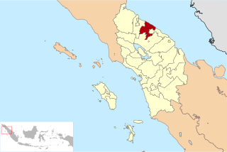
Riau is a province of Indonesia. It is located on the central eastern coast of Sumatra along the Strait of Malacca. The province shares land borders with North Sumatra to the northwest, West Sumatra to the west, and Jambi to the south, and a maritime border with the Riau Islands and the country of Malaysia to the east. It is the second-largest province in the island of Sumatra after South Sumatra, and is slightly larger than Jordan. According to the 2020 census, Riau had a population of 6,394,087 across a land area of 89,935.90 km²; the official estimate of population as of mid-2022 was 6,614,384. The province comprises ten regencies and two cities, with Pekanbaru serving as the capital and largest city.

Bulungan Regency is a regency of North Kalimantan Province in Indonesia. It covers an area of 13,181.92 km2 and had a population of 112,663 at the 2010 Census and 151,844 at the 2020 Census; the official estimate as at mid 2023 was 165,775. The administrative centre is at Tanjung Selor.

Dumai, is a coastal city in Riau Province on the island of Sumatra, Indonesia. The city has an area of 2,066.72 km2 and had 331,832 inhabitants at mid 2022 official estimate. Dumai has a domestic airport, Pinang Kampai Airport. Dumai is an important transport and trade centre, both regionally and internationally, especially to Malaysia. Dumai is rich in oil.

Indragiri Hilir is the most eastern regency (kabupaten) of Riau Province, Indonesia. It is located on the island of Sumatra. The regency has an area of 13,525.10 km2 and had a population of 661,779 at the 2010 census and 654,909 at the 2020 Census; the official estimate as at mid 2022 was 660,747. The administrative centre of the regency is the town of Tembilahan.

Kuantan Singingi is a regency (kabupaten) of Riau, Indonesia. It is located on the island of Sumatra. The regency was created on 4 October 1999 from what had been the western half of Indragiri Hulu Regency. It has an area of 7,656.03 km2 and had a population of 292,116 at the 2010 Census and 334,943 at the 2020 Census; the official estimate as at mid 2022 was 345,850. The seat of the regency is the town of Teluk Kuantan.

Rokan Hulu is a regency (kabupaten) of Riau, Indonesia. It is located on the island of Sumatra. Rokan Hulu Regency was created on 4 October 1999 as a result of the division of Kampar Regency, of which it was previously the western 24%. The new Regency was established under Law No. 53 of 1999 and Law No. 11 of 2003 on changes to Law Decree No. 53 of 1999, which is reinforced by the Constitutional Court Decision No. 010 / PUU-1/2004, dated 26 August 2004. It mainly occupies the upper part of the catchment area of the Rokan River, and has an area of 7,588.13 km². It had 474,843 inhabitants at the 2010 Census and 561,385 at the 2020 Census; the official estimate as at mid 2022 was 582,679. The administrative centre of the regency is located at Pasir Pengaraian.
Rokan Hilir is a regency (kabupaten) of Riau Province, on Sumatra island, Indonesia. It was formed on 4 October 1999 from districts which had previously been the northwestern part of Bengkalis Regency. It occupies the lower part of the catchment area of the Rokan River, and has an area of 8,851.59 km2. It had a population of 553,216 at the 2010 census and 637,161 at the 2020 census; the official estimate as at mid 2022 was 638,407. The administrative centre of the Rokan Hilir Regency is located at the town of Bagansiapiapi.
Siak, is a regency (kabupaten) of Riau Province, on the island of Sumatra, Indonesia. It has an area of 8,556.09 km2 and had a population of 376,742 at the 2010 Census and 457,940 at the 2020 Census; the official estimate as at mid 2022 was 477,550, comprising 246,186 males and 231,364 females. The administrative centre of the regency is located at Siak Sri Indrapura. The northern part of this regency contains a large part of the Bukit Batu Biosphere Reserve.

Tanah Bumbu is one of the regencies in the Indonesian province of South Kalimantan. It was formerly part of Kotabaru Regency, but was split off on 25 February 2003 to form a separate regency, following dissatisfaction on the Kalimantan mainland territories with administration from Laut Island. It covers an area of 4,890.3 km2 and had a population of 267,929 at the 2010 Census and 322,646 at the 2020 Census; the latest official estimate is 343,741. The regency's capital is the town of Batulicin.

North Bengkulu is a regency of Bengkulu Province, Indonesia, on the island of Sumatra. It originally covered much of the northern part of Bengkulu Province, but on 25 February 2003 the most northwesterly districts were split off to form a separate Mukomuko Regency, and on 24 June 2008 the most southeastern districts were likewise split off to create a new Central Bengkulu Regency. The residual regency now covers an area of 4,424.59 km2, and it had a population of 257,675 at the 2010 Census and 296,523 at the 2020 Census; the official estimate as at mid 2022 was 302,833. The administrative centre is at the town of Arga Makmur.

Labuhanbatu Regency, alternatively written in space as Labuhan Batu Regency, is a regency of North Sumatra Province in Indonesia. Its administrative seat is Rantau Prapat. An original regency of the province, it had an area of 9,703 km2 as at early 2008, prior to the separation out of its southern and its north-western districts respectively to create the new South Labuhanbatu and North Labuhanbatu Regencies on 21 July 2008.

South Labuhanbatu Regency is a regency of North Sumatra Province of Indonesia, created on 21 July 2008 by being carved out of the southern districts of the existing Labuhanbatu Regency. The new South Labuhanbatu Regency covers an area of 3,596 square kilometres and according to the 2010 census it had a population of 277,673, which rose to 314,094 at the 2020 Census; the official estimate as at mid 2023 was 330,797. Its administrative headquarters are at the town of Kotapinang.

Mandailing Natal, abbreviated as Madina, is a regency in North Sumatra Province of Indonesia. It covers an area of 6,620.70 square kilometres and it had a population of 403,894 people at the 2010 census and 472,886 at the 2020 Census; the official estimate as at mid 2023 was 496,975. The capital lies at Panyabungan. The Regency was formerly a part of South Tapanuli Regency until it was created as a separate regency on 23 November 1998. It is the southernmost regency in North Sumatra, and the largest regency by land area in the province, with Langkat Regency second to it.
Serdang Bedagai Regency is a regency on the east coast of North Sumatra Province of Indonesia, facing Malaysia, with 95 km of coastline and covering an area of 1,900.22 square kilometres, divided into seventeen districts (kecamatan), in turn subdivided into 243 villages. Its administrative centre is the town of Sei Rampah. The regency surrounds the independent city of Tebing Tinggi, and also contains a district (kecamatan) by the same name. The name “Serdang Bedagai” was derived from the two Sultanates which formerly existed in the Region; they were Serdang Sultanate and Padang Bedagai Sultanate. The population was 592,922 at the 2010 Census, while the 2020 Census produced a total of 657,490; the official estimate as at mid 2023 was 682,918.

Meranti Islands is an archipelago forming a regency (kabupaten) of Riau Province and lies off the eastern coast of the island of Sumatra, Indonesia. It was created on 19 December 2008 by the separating of this archipelago from the mainland regency of Bengkalis. The regency comprises the islands of Tebing Tinggi, Rangsang, Padang, and Merbau, together with minor offshore islands, but does not include Bengkalis Island which is geographically part of the archipelago but remains within Bengkalis Regency. The principal town is Selat Panjang on Tebing Tinggi Island. The regency covers an area of 3,623.93 km2 and had a population of 176,290 at the 2010 Census and 206,116 at the 2020 Census; the official estimate as of mid-2022 was 213,532.

Banyuasin is a regency of South Sumatra Province in Indonesia. The Regency was formed on 10 April 2002 from the coastal and eastern areas formerly part of the Musi Banyuasin Regency. It takes its name from the main river which drains that area, the Banyuasin River. Pangkalan Balai is the regency seat. The regency borders Musi Banyuasin Regency, Jambi province and Bangka Strait to the north, Bangka Strait to the east, Ogan Komering Ilir Regency, Muara Enim Regency, and the city of Palembang to the south, and Musi Banyuasin Regency to the west. It has an area of 12,551.15 km2 and had a population of 749,107 at the 2010 census and 836,914 at the 2020 census; the official estimate as at mid 2023 was 850,022. Much of the regency is coastal lowland.

West Kotawaringin Regency is one of the thirteen regencies which comprise the Central Kalimantan Province on the island of Kalimantan (Borneo), Indonesia. It originally comprised the whole western part of the province, having been split from a single Kotawaringin Regency on 26 June 1959 into separate regencies for West and East Kotawaringin, but on 10 April 2002 the most westerly districts of West Kotawaringin were split off to form the new Lamandau Regency and Sukamara Regency. The residual West Kotawaringin Regency has a land area of about 10,759 km2, and its population was 235,803 at the 2010 Census and 270,388 at the 2020 Census; the official estimate as at mid 2023 was 279,740. The town of Pangkalan Bun in Arut Selatan District is the capital of West Kotawaringin Regency.

East Kotawaringin Regency is one of the thirteen regencies which comprise the Central Kalimantan Province on the island of Kalimantan (Borneo), Indonesia. It originally covered a much larger part of the province, having been split from a single Kotawaringin Regency on 26 June 1959 into separate regencies for East and West Kotawaringin, but on 10 April 2002 several districts in the west of the regency were split off to form the new Seruyan Regency, and several districts in the east of the regency were similarly split off to form the new Katingan Regency. The area of the residual East Kotawaringin Regency is 16,796 km2, and its population was 374,175 at the 2010 Census, and 428,900 at the 2020 Census; the official estimate as at mid 2023 was 443,359. The town of Sampit is the capital of East Kotawaringin Regency.

West Tulang Bawang Regency is a regency (kabupaten) of Lampung Province, Sumatra, Indonesia. It was created on 29 October 2008 from what were formerly the western districts of Tulang Bawang Regency. It has an area of 1,201.15 km2 and had a population of 250,707 people at the 2010 Census and 286,162 at the 2020 Census; the official estimate as at mid 2023 was 295,481. The regency seat is the town of Panaragan Jaya.