The Potomac River is found within the Mid-Atlantic region of the United States and flows from the Potomac Highlands into the Chesapeake Bay. The river is approximately 405 miles (652 km) long, with a drainage area of about 14,700 square miles (38,000 km2). In terms of area, this makes the Potomac River the fourth largest river along the East Coast of the United States and the 21st largest in the United States. Over 5 million people live within the Potomac watershed.

Floyd County is a county located in the Commonwealth of Virginia. As of the 2020 census, the population was 15,476. Its county seat is the town of Floyd. Floyd County is included in the Blacksburg-Christiansburg, VA Metropolitan Statistical Area.

Bent Creek is a census-designated place (CDP) in Buncombe County, North Carolina, United States. The population was 1,287 at the 2010 census. The Bent Creek area has mountain bike trails within the Pisgah National Forest.

The Sand Creek massacre was a massacre of Cheyenne and Arapaho people by the U.S. Army in the American Indian Wars that occurred on November 29, 1864, when a 675-man force of the Third Colorado Cavalry under the command of U.S. Volunteers Colonel John Chivington attacked and destroyed a village of Cheyenne and Arapaho people in southeastern Colorado Territory, killing and mutilating an estimated 69 to over 600 Native American people. Chivington claimed 500 to 600 warriors were killed. However, most sources estimate around 150 people were killed, about two-thirds of whom were women and children. The location has been designated the Sand Creek Massacre National Historic Site and is administered by the National Park Service. The massacre is considered part of a series of events known as the Colorado War.
U.S. Route 119 (US 119) is a spur of US 19. It is a north–south route that was an original United States highway of 1926. It is Corridor G of the Appalachian Development Highway System (ADHS) east of US 23 and KY 80 in Kentucky to Interstate 64 at Charleston, West Virginia.

The Roanoke Metropolitan Statistical Area is a Metropolitan Statistical Area (MSA) in Virginia as defined by the United States Office of Management and Budget (OMB). The Roanoke MSA is sometimes referred to as the Roanoke Valley, even though the Roanoke MSA occupies a larger area than the Roanoke Valley. It is geographically similar to the area known as the Roanoke Region of Virginia, but while the latter includes Alleghany County, the former does not. As of the 2020 census, the MSA had a population of 315,251.

The Colorado War was an Indian War fought in 1864 and 1865 between the Southern Cheyenne, Arapaho, and allied Brulé and Oglala Sioux peoples versus the U.S. army, Colorado militia, and white settlers in Colorado Territory and adjacent regions. The Kiowa and the Comanche played a minor role in actions that occurred in the southern part of the Territory along the Arkansas River. The Cheyenne, Arapaho, and Sioux played the major role in actions that occurred north of the Arkansas River and along the South Platte River, the Great Platte River Road, and the eastern portion of the Overland Trail. The United States government and Colorado Territory authorities participated through the 1st Colorado Cavalry Regiment, often called the Colorado volunteers. The war was centered on the Colorado Eastern Plains, extending eastward into Kansas and Nebraska.

William Wells Bent was a frontier trader and rancher in the American West, with forts in Colorado. He also acted as a mediator among the Cheyenne Nation, other Native American tribes and the expanding United States. With his brothers, Bent established a trade business along the Santa Fe Trail. In the early 1830s Bent built an adobe fort, called Bent's Fort, along the Arkansas River in present-day Colorado. Furs, horses and other goods were traded for food and other household goods by travelers along the Santa Fe trail, fur-trappers, and local Mexican and Native American people. Bent negotiated a peace among the many Plains tribes north and south of the Arkansas River, as well as between the Native American and the United States government.

Fort Lyon was composed of two 19th-century military fort complexes in southeastern Colorado. The initial fort, also called Fort Wise, operated from 1860 to 1867. After a flood in 1866, a new fort was built near Las Animas, Colorado, which operated as a military post until 1897.
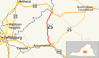
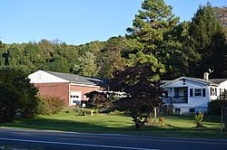
State Route 26 is a primary state highway in the U.S. state of Virginia. Known as Oakville Road, the state highway runs 12.83 miles (20.65 km) from U.S. Route 460, SR 24, and US 460 Business in Appomattox north to US 60 in Bent Creek.

U.S. Route 221 (US 221) is a part of the U.S. Highway System that runs from Perry, Florida to Lynchburg, Virginia. In Virginia, the U.S. Highway runs 149.61 miles (240.77 km) from the North Carolina state line near Independence north to its northern terminus at US 29 Business, US 460 Business, and US 501 Business in Lynchburg. US 221 connects Independence, Galax, and Hillsville in Southwest Virginia while running concurrently with US 58. The U.S. Highway connects those communities with Roanoke via Floyd County, within which US 221 is the main east–west highway. The U.S. Highway also runs concurrently with US 460 from Roanoke to Bedford and parallels that U.S. Highway from Bedford to Lynchburg.

Briery Creek Wildlife Management Area is a 3,164-acre (12.80 km2) Wildlife Management Area in Prince Edward County, Virginia. With terrain typical of Virginia's south-central Piedmont, it encompasses the 845-acre (3.42 km2) Briery Creek Lake, a reservoir formed by the damming of Briery Creek and Little Briery Creek. Much of the area was historically used for tobacco farming, and more recently, timber production; today the land contains a mixture of hardwoods and loblolly pine.
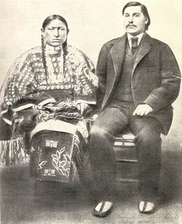
George Bent, also named Ho—my-ike in Cheyenne, was a Cheyenne who became a Confederate soldier during the American Civil War and waged war against Americans as a Cheyenne warrior afterward. He was the mixed-race son of Owl Woman, daughter of a Cheyenne chief, and the American William Bent, founder of the trading post named Bent's Fort and a trading partnership with his brothers and Ceran St. Vrain. Bent was born near present-day La Junta, Colorado, and was reared among both his mother's people, his father and other European Americans at the fort, and other whites from the age of 10 while attending boarding school in St. Louis, Missouri. He identified as Cheyenne.
Bent Mountain is an unincorporated community in Roanoke County, Virginia, United States. Bent Mountain is located on U.S. Route 221 13.6 miles (21.9 km) southwest of Roanoke. Bent Mountain has a post office with ZIP code 24059.

Amache Ochinee Prowers, also known as Walking Woman (1846–1905), was a Native American activist, advocate, cattle rancher, and operator of a store on the Santa Fe Trail. Her father was a Cheyenne peace chief who was killed during the Sand Creek massacre on November 29, 1864, after which she became a mediator between Colorado territorial settlers, Mexicans, and Native Americans during the 1860s and 1870s. She was inducted into the Colorado Women's Hall of Fame in 2018.

History of slavery in Colorado began centuries before Colorado achieved statehood when Spanish colonists of Santa Fe de Nuevo México (1598–1848) enslaved Native Americans, called Genízaros. Southern Colorado was part of the Spanish territory until 1848. Comanche and Utes raided villages of other indigenous people and enslaved them.

The North Branch Potomac River flows from Fairfax Stone in West Virginia to its confluence with the South Branch Potomac River near Green Spring, West Virginia, where it turns into the Potomac River proper.