
Range Regional Airport is a public use airport located four nautical miles southeast of the central business district of Hibbing, in Saint Louis County, Minnesota, United States. It was formerly known as Chisholm-Hibbing Airport or Chisholm-Hibbing Municipal Airport. The airport is mostly used for general aviation but is also served by one commercial and one charter airline. Scheduled passenger service is subsidized by the Essential Air Service program.

Columbus Airport is four miles northeast of Columbus, in Muscogee County, Georgia, United States. Serving Georgia's second largest city, it is Georgia's fourth busiest airport.

Helena Regional Airport is a public airport two miles northeast of Helena, in Lewis and Clark County, Montana, United States. It is owned by the Helena Regional Airport Authority.
Miles City Airport or Frank Wiley Field is a city-owned airport two miles northwest of Miles City, in Custer County, Montana, United States. The airport was served by one airline, subsidized by the Essential Air Service program. EAS subsidies ended on July 15, 2013, due to subsidy per passenger exceeding $1000, leaving Miles City without scheduled air service.

Tom Madsen Airport is a state-owned public-use airport in City of Unalaska, on Amaknak Island in the Aleutian Islands, off the coast of the U.S. state of Alaska. It is located near the Bering Sea coast of Unalaska Island, 800 miles (1,300 km) southwest of Anchorage and 1,950 miles (3,140 km) from Seattle.
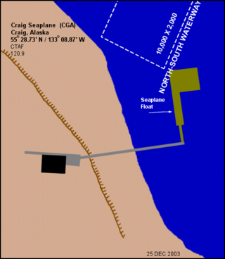
Craig Seaplane Base is a public use seaplane base owned by and located in Craig, a city in the Prince of Wales-Hyder Census Area of the U.S. state of Alaska.
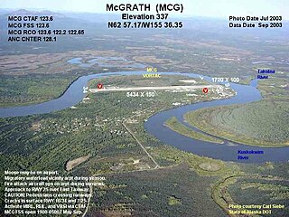
McGrath Airport is a state-owned public-use airport serving McGrath, a city in the Yukon-Koyukuk Census Area of the U.S. state of Alaska.

Ralph M. Calhoun Memorial Airport is a state-owned public-use airport located one nautical mile (1.85 km) west of the central business district of Tanana, a city in the Yukon-Koyukuk Census Area of the U.S. state of Alaska.

Astoria Regional Airport is a joint civil-military public airport in Warrenton, three miles southwest of Astoria, in Clatsop County, Oregon. The airport is owned by the Port of Astoria and is the home of Coast Guard Air Station Astoria.
Welke Airport is a privately-owned, public use airport located on Beaver Island in Charlevoix County, Michigan, United States. Scheduled passenger service to Charlevoix Municipal Airport in Charlevoix, Michigan, is provided by Island Airways.

Ketchikan Harbor Seaplane Base is a privately owned, public use seaplane base located at the harbor of Ketchikan, a city in the Ketchikan Gateway Borough of the U.S. state of Alaska. It is located near the Ketchikan International Airport, which also has its own seaplane landing area. Prior to the opening of the Ketchikan International Airport in 1973, scheduled passenger seaplane service was operated with amphibian aircraft between the seaplane base and the Annette Island Airport located approximately 20 miles south, as this land plane airfield previously served as the primary airport for Ketchikan, with scheduled airline flights being operated by Pan American World Airways, Pacific Northern Airlines and Western Airlines into Annette Island over the years.

Anaktuvuk Pass Airport is a public use airport located in Anaktuvuk Pass, a city in the North Slope Borough of the U.S. state of Alaska. The airport is owned by North Slope Borough.
Nulato Airport is a state-owned public-use airport located one nautical mile (2 km) northeast of the central business district of Nulato, a city in the Yukon-Koyukuk Census Area of the U.S. state of Alaska.
St. George Airport is a state-owned public-use airport located four nautical miles from the central business district of St. George, a city on St. George Island in the Aleutians West Census Area of the U.S. state of Alaska. Scheduled passenger airline service is provided by Grant Aviation.

Kobuk Airport is a state-owned public-use airport located in Kobuk, a city in the Northwest Arctic Borough of the U.S. state of Alaska.
Old Harbor Airport is a state owned, public use airport located two nautical miles (4 km) northeast of the central business district of Old Harbor, a city in the Kodiak Island Borough in the U.S. state of Alaska.
Ouzinkie Airport is a state-owned public-use airport serving Ouzinkie, a city on Spruce Island in the Kodiak Island Borough of the U.S. state of Alaska.
Venetie Airport is a public use airport located in Venetie, in the Yukon-Koyukuk Census Area of the U.S. state of Alaska. It is privately owned by the Venetie Tribal Government.
Port Lions Airport is a state-owned, public-use airport located two nautical miles northeast of the central business district of Port Lions, a city located on Kodiak Island in the Kodiak Island Borough of the U.S. state of Alaska.

Hollis Clark Bay Seaplane Base is a state owned, public use seaplane base located one nautical mile (2 km) northeast of the central business district of Hollis, a community in the Prince of Wales-Hyder Census Area in the U.S. state of Alaska. It was formerly known as Hollis Seaplane Base.


