Silver Bow County | |
---|---|
Butte-Silver Bow County | |
Coordinates: 45°54′N112°40′W / 45.9°N 112.66°W | |
Country | United States |
State | Montana |
Founded | February 16, 1881 |
Named for | Silver Bow Creek |
Seat | Butte |
Largest city | Butte |
Government | |
• Chief Executive | J.P. Gallagher |
Area | |
• Total | 719 sq mi (1,860 km2) |
• Land | 718 sq mi (1,860 km2) |
• Water | 0.6 sq mi (2 km2) 0.08% |
Population (2020) | |
• Total | 35,133 |
• Estimate (2022) | 36,068 |
• Density | 49/sq mi (19/km2) |
Time zone | UTC−7 (Mountain) |
• Summer (DST) | UTC−6 (MDT) |
Congressional district | 1st |
Website | co |
|
Silver Bow County is a county in the U.S. state of Montana. As of the 2020 census, the population was 35,133. [1] Its county seat is Butte. [2] In 1977, the city and county governments consolidated to form the single entity of Butte-Silver Bow. Additionally, the town of Walkerville is a separate municipality from Butte and is within the county.
Silver Bow County comprises the Butte-Silver Bow, MT Micropolitan Statistical Area.
According to the United States Census Bureau, the county has an area of 719 square miles (1,860 km2), of which 718 square miles (1,860 km2) is land and 0.6 square miles (1.6 km2) (0.08%) is water. [3] It is Montana's smallest county by area.
Census | Pop. | Note | %± |
---|---|---|---|
1890 | 23,744 | — | |
1900 | 47,635 | 100.6% | |
1910 | 56,848 | 19.3% | |
1920 | 60,313 | 6.1% | |
1930 | 56,969 | −5.5% | |
1940 | 53,209 | −6.6% | |
1950 | 48,422 | −9.0% | |
1960 | 46,454 | −4.1% | |
1970 | 41,981 | −9.6% | |
1980 | 38,092 | −9.3% | |
1990 | 33,941 | −10.9% | |
2000 | 34,606 | 2.0% | |
2010 | 34,200 | −1.2% | |
2020 | 35,133 | 2.7% | |
2022 (est.) | 36,068 | [4] | 2.7% |
U.S. Decennial Census [5] 1790–1960, [6] 1900–1990, [7] 1990–2000, [8] 2010–2020 [1] |
As of the 2020 census, there were 35,133 people living in the county.[ citation needed ]
As of the 2010 census, there were 34,200 people, 14,932 households, and 8,651 families living in the county. The population density was 47.6 inhabitants per square mile (18.4/km2). There were 16,717 housing units at an average density of 23.3 per square mile (9.0/km2). The racial makeup of the county was 94.4% white, 1.9% American Indian, 0.5% Asian, 0.3% black or African American, 0.1% Pacific islander, 0.7% from other races, and 2.1% from two or more races. Those of Hispanic or Latino origin made up 3.7% of the population. In terms of ancestry, 32.6% were Irish, 23.3% were German, 16.1% were English, 8.3% were Italian, 6.9% were Norwegian, and 3.2% were American.
Of the 14,932 households, 26.0% had children under the age of 18 living with them, 42.2% were married couples living together, 10.6% had a female householder with no husband present, 42.1% were non-families, and 35.1% of all households were made up of individuals. The average household size was 2.22 and the average family size was 2.87. The median age was 41.3 years.
The median income for a household in the county was $37,986 and the median income for a family was $52,288. Males had a median income of $41,491 versus $28,132 for females. The per capita income for the county was $21,357. About 11.6% of families and 17.8% of the population were below the poverty line, including 23.1% of those under age 18 and 8.9% of those age 65 or over.
Since 1977, Butte and Silver Bow County have been consolidated into one governmental body under the leadership of the chief executive and the council of commissioners. Elected in November 2020, J.P. Gallagher is the incumbent Chief Executive of Butte-Silver Bow, a nonpartisan office. [9]
A Democratic bastion, Silver Bow County is, along with neighboring Deer Lodge County, one of the two most consistently Democratic-voting counties in Montana in presidential elections, having last voted Republican in 1956 for Dwight D. Eisenhower.
Over the last century, Silver Bow County has voted only once for a Republican gubernatorial candidate (Marc Racicot during the 1996 election). [10] Silver Bow County has not supported any Republican at all for the U.S. Senate since at least 1928. [10]
Silver Bow County is in Montana Senate districts 36 (represented by Republican Jeffrey Welborn), 37 (represented by Democrat Ryan Lynch), 38 (represented by Democrat Edith McClafferty), and 39 (represented by Republican Terry Vermeire). In the Montana House of Representatives, the county is in districts 71 (represented by Republican Kenneth Walsh), 72 (represented by Republican Tom Welch), 73 (represented by Democrat Jennifer Lynch), 74 (represented by Democrat Derek J. Harvey), 76 (represented by Democrat Donavon Hawk), and 78 (represented by Republican Gregory Frazer). [11]
From 2024 to 2032, Silver Bow County will be in State Senate districts 35, 36, and 37, as well as State House of Representatives districts 70, 71, 72, 73, and 74. Two of the three Senate districts are expected to be favorable to Democrats as well as four of the five House districts. [12]
Year | Republican | Democratic | Third party | |||
---|---|---|---|---|---|---|
No. | % | No. | % | No. | % | |
2020 | 7,745 | 41.51% | 10,392 | 55.70% | 521 | 2.79% |
2016 | 6,376 | 38.76% | 8,619 | 52.39% | 1,457 | 8.86% |
2012 | 5,430 | 32.41% | 10,857 | 64.79% | 469 | 2.80% |
2008 | 4,818 | 28.27% | 11,676 | 68.51% | 548 | 3.22% |
2004 | 6,381 | 39.67% | 9,307 | 57.86% | 396 | 2.46% |
2000 | 6,299 | 37.71% | 8,967 | 53.68% | 1,437 | 8.60% |
1996 | 3,909 | 22.11% | 11,199 | 63.35% | 2,569 | 14.53% |
1992 | 3,491 | 19.24% | 9,960 | 54.89% | 4,695 | 25.87% |
1988 | 5,043 | 30.22% | 11,422 | 68.45% | 222 | 1.33% |
1984 | 6,637 | 36.85% | 11,095 | 61.60% | 278 | 1.54% |
1980 | 7,301 | 37.68% | 9,721 | 50.17% | 2,355 | 12.15% |
1976 | 7,506 | 39.28% | 11,377 | 59.53% | 227 | 1.19% |
1972 | 7,967 | 39.05% | 11,704 | 57.36% | 733 | 3.59% |
1968 | 5,488 | 27.98% | 12,626 | 64.36% | 1,503 | 7.66% |
1964 | 4,873 | 22.94% | 15,751 | 74.16% | 615 | 2.90% |
1960 | 7,290 | 34.40% | 13,754 | 64.91% | 146 | 0.69% |
1956 | 11,619 | 50.31% | 11,475 | 49.69% | 0 | 0.00% |
1952 | 10,196 | 43.46% | 13,114 | 55.90% | 148 | 0.63% |
1948 | 7,305 | 34.24% | 12,715 | 59.60% | 1,315 | 6.16% |
1944 | 7,610 | 36.17% | 13,228 | 62.87% | 202 | 0.96% |
1940 | 7,932 | 30.82% | 17,467 | 67.88% | 335 | 1.30% |
1936 | 4,528 | 20.02% | 17,697 | 78.23% | 398 | 1.76% |
1932 | 6,792 | 31.11% | 13,626 | 62.41% | 1,416 | 6.49% |
1928 | 9,456 | 44.81% | 11,228 | 53.21% | 419 | 1.99% |
1924 | 6,520 | 34.66% | 5,393 | 28.66% | 6,901 | 36.68% |
1920 | 10,074 | 55.36% | 6,394 | 35.14% | 1,730 | 9.51% |
1916 | 6,757 | 31.36% | 13,084 | 60.72% | 1,706 | 7.92% |
1912 | 2,232 | 18.76% | 4,542 | 38.18% | 5,122 | 43.06% |
1908 | 4,618 | 33.82% | 6,255 | 45.80% | 2,783 | 20.38% |
1904 | 5,149 | 36.07% | 5,686 | 39.83% | 3,439 | 24.09% |
1900 | 3,873 | 23.75% | 12,101 | 74.19% | 336 | 2.06% |
1896 | 1,275 | 11.29% | 9,992 | 88.46% | 29 | 0.26% |
1892 | 3,251 | 38.58% | 2,648 | 31.43% | 2,527 | 29.99% |
Crook County is a county in the northeastern corner of the U.S. state of Wyoming. As of the 2020 United States Census, the population was 7,181, making it the third-least populous county in Wyoming. Its county seat and largest city is Sundance. The county is located at the northwestern extreme of the Black Hills, which are its defining geographical feature.
Meade County is a county in the U.S. state of South Dakota. As of the 2020 census, the population was 29,852, making it the 6th most populous county in South Dakota. Its county seat is Sturgis. The county was created in 1889 and named for Fort Meade, which was garrisoned as a United States military post in the area in 1878 and itself named for General George Meade.
Harding County is a county in the U.S. state of South Dakota. As of the 2020 census, the population was 1,311, making it the third-least populous county in South Dakota. Its county seat is Buffalo.
Butte County is a county in the U.S. state of South Dakota. As of the 2020 census, the population was 10,243. Its county seat is Belle Fourche. The county was established in the Dakota Territory on March 2, 1883, and given the descriptive name based on the French word for a hill.
Hitchcock County is a county in the U.S. state of Nebraska. As of the 2020 United States Census, the population was 2,616. Its county seat is Trenton.
Box Butte County is a county in the U.S. state of Nebraska. As of the 2020 United States Census, the population was 10,842. Its county seat is Alliance. The county was formed in 1886; it took its name from a large box-shaped butte north of Alliance.
Ravalli County is a county in the southwestern part of the U.S. state of Montana. As of the 2020 census, the population was 44,174. Its county seat is Hamilton.
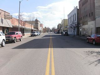
Powell County is a county in the U.S. state of Montana. As of the 2020 census, the population was 6,946. Its county seat is Deer Lodge.
Musselshell County is a county in south-central Montana. As of the 2020 census, the population was 4,730. Its county seat is Roundup.
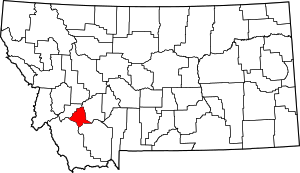
Madison County is a county in the U.S. state of Montana. As of the 2020 census, the population was 8,623. Its county seat is Virginia City. The county was founded in 1865; at the time it was part of the Montana Territory.
Lewis and Clark County is a county located in the U.S. state of Montana. As of the 2020 census, the population was 70,973. Its county seat is Helena, the state capital. The numerical designation for Lewis and Clark County is 5. The county was established on June 2, 1865, as one of the nine original counties of the Territory of Montana named Edgerton County in honor of Sidney Edgerton, first Governor of the Territory of Montana, and was renamed Lewis and Clark County on March 1, 1868, in honor of explorers Meriwether Lewis and William Clark.
Gallatin County is located in the U.S. state of Montana. With its county seat in Bozeman, it is the second-most populous county in Montana, with a population of 118,960 in the 2020 Census.
Deer Lodge County is a county in the U.S. state of Montana. As of the 2020 census, the population was 9,421. It forms a consolidated city-county government with its county seat of Anaconda. The county was established in 1865.
Carter County is a county located in the U.S. state of Montana. As of the 2020 census, the population was 1,415, making it the seventh-least populous county in Montana. The county seat is Ekalaka.
Beaverhead County is the largest county by area in the U.S. state of Montana. As of the 2020 census, the population was 9,371. Its county seat is Dillon. The county was founded in 1865.
Clark County is a rural county in the U.S. state of Idaho; its county seat and largest city is Dubois. As of the 2020 census, the population was 790, making it the least populous county in the state.
Dorris is a city in Siskiyou County, California, United States. Its population is 860 as of the 2020 census, down from 939 from the 2010 census. The town being small, the only attractions are the flagpole and county library. The most notable people who have been residents of Dorris are two athletes who were born here.
Dillon is a city in and the county seat of Beaverhead County, Montana, United States. The population was 3,880 at the 2020 census. The city was named for Sidney Dillon (1812–1892), president of Union Pacific Railroad.
Whitehall is a town in Jefferson County, Montana, United States. The population was 1,006 at the 2020 census. It is part of the Helena Micropolitan Statistical Area.
Walkerville is a town in Silver Bow County, Montana, United States, that is an enclave of the consolidated city-county of Butte. The population was 639 at the 2020 census. Walkerville is a suburb of Butte, and the only other incorporated community in the county, as well as the only part of the county that is not part of Butte.