Custer County, Montana

Last updated

Custer County
Miles City MT Custer County Courthouse.jpg
Custer County Courthouse in Miles City
Map of Montana highlighting Custer County.svg
Location within the U.S. state of Montana
Montana in United States.svg
Montana's location within the U.S.
Coordinates: 46°16′N105°35′W / 46.27°N 105.58°W / 46.27; -105.58
CountryFlag of the United States.svg United States
StateFlag of Montana.svg  Montana
FoundedJune 2, 1865
Named for George Armstrong Custer
Seat Miles City
Largest cityMiles City
Area
  Total3,793 sq mi (9,820 km2)
  Land3,783 sq mi (9,800 km2)
  Water9.9 sq mi (26 km2)  0.3%
Population
 (2020)
  Total11,867
  Estimate 
(2022)
12,032 Increase2.svg
  Density3.1/sq mi (1.2/km2)
Time zone UTC−7 (Mountain)
  Summer (DST) UTC−6 (MDT)
Congressional district 2nd
Website https://custercountymt.com/
  • Montana county number 14

Custer County is a county located in the U.S. state of Montana. As of the 2020 census, the population was 11,867. [1] Its county seat is Miles City. [2] The county was established on June 2, 1865, as one of the nine original counties of the Territory of Montana named Big Horn County, [3] and was renamed on February 16, 1877, in honor of Lieutenant Colonel George Armstrong Custer. [4]

Contents

Geography

According to the United States Census Bureau, the county has a total area of 3,793 square miles (9,820 km2), of which 3,783 square miles (9,800 km2) is land and 9.9 square miles (26 km2) (0.3%) is water. [5]

Climate

According to the Köppen Climate Classification system, Custer County has a mostly cold semi-arid climate, abbreviated "BSk" on climate maps.

Climate data for Mizpah, Montana, 1991—2020 normals, extremes 1960—present
MonthJanFebMarAprMayJunJulAugSepOctNovDecYear
Record high °F (°C)69
(21)
73
(23)
85
(29)
92
(33)
101
(38)
111
(44)
112
(44)
110
(43)
106
(41)
96
(36)
80
(27)
70
(21)
112
(44)
Mean maximum °F (°C)51.6
(10.9)
56.3
(13.5)
71.9
(22.2)
81.3
(27.4)
87.2
(30.7)
95.8
(35.4)
102.5
(39.2)
101.5
(38.6)
97.1
(36.2)
84.2
(29.0)
67.9
(19.9)
54.2
(12.3)
104.4
(40.2)
Mean daily maximum °F (°C)32.6
(0.3)
36.9
(2.7)
49.7
(9.8)
61.2
(16.2)
70.9
(21.6)
81.1
(27.3)
91.3
(32.9)
90.9
(32.7)
79.4
(26.3)
62.1
(16.7)
46.4
(8.0)
35.2
(1.8)
61.5
(16.4)
Daily mean °F (°C)19.4
(−7.0)
23.7
(−4.6)
35.4
(1.9)
46.1
(7.8)
55.8
(13.2)
65.6
(18.7)
73.5
(23.1)
72.0
(22.2)
61.0
(16.1)
46.2
(7.9)
32.3
(0.2)
21.9
(−5.6)
46.1
(7.8)
Mean daily minimum °F (°C)6.3
(−14.3)
10.6
(−11.9)
21.0
(−6.1)
31.0
(−0.6)
40.8
(4.9)
50.1
(10.1)
55.6
(13.1)
53.0
(11.7)
42.6
(5.9)
30.4
(−0.9)
18.3
(−7.6)
8.6
(−13.0)
30.7
(−0.7)
Mean minimum °F (°C)−23.5
(−30.8)
−15.4
(−26.3)
−4.1
(−20.1)
13.1
(−10.5)
24.3
(−4.3)
36.1
(2.3)
43.2
(6.2)
37.6
(3.1)
25.5
(−3.6)
12.3
(−10.9)
−6.3
(−21.3)
−17.2
(−27.3)
−32.0
(−35.6)
Record low °F (°C)−45
(−43)
−45
(−43)
−40
(−40)
−5
(−21)
13
(−11)
21
(−6)
33
(1)
31
(−1)
16
(−9)
−11
(−24)
−29
(−34)
−49
(−45)
−49
(−45)
Average precipitation inches (mm)0.44
(11)
0.48
(12)
0.70
(18)
1.65
(42)
2.92
(74)
2.31
(59)
1.78
(45)
1.02
(26)
1.26
(32)
1.04
(26)
0.50
(13)
0.41
(10)
14.51
(368)
Average snowfall inches (cm)5.6
(14)
5.0
(13)
5.4
(14)
2.2
(5.6)
0.8
(2.0)
0.0
(0.0)
0.0
(0.0)
0.0
(0.0)
0.1
(0.25)
1.6
(4.1)
3.7
(9.4)
5.5
(14)
29.9
(76.35)
Average precipitation days (≥ 0.01 in)6.26.36.38.410.510.48.05.86.37.25.75.987.0
Average snowy days (≥ 0.1 in)4.74.43.21.30.30.00.00.00.01.03.24.822.9
Source 1: NOAA [6]
Source 2: National Weather Service [7]

Major highways

Transit

Adjacent counties

Demographics

Historical population
CensusPop.Note
1870 38
1880 2,5106,505.3%
1890 5,308111.5%
1900 7,89148.7%
1910 14,12379.0%
1920 12,194−13.7%
1930 11,242−7.8%
1940 10,422−7.3%
1950 12,66121.5%
1960 13,2274.5%
1970 12,174−8.0%
1980 13,1097.7%
1990 11,697−10.8%
2000 11,6960.0%
2010 11,6990.0%
2020 11,8671.4%
2022 (est.)12,032 [8] 1.4%
U.S. Decennial Census [9]
1790–1960, [10] 1900–1990, [11]
1990–2000, [12] 2010–2020 [1]

2020 census

As of the 2020 census, there were 11,867 people living in the county.[ citation needed ]

2010 census

As of the 2010 census, there were 11,699 people, 5,031 households, and 3,014 families living in the county. The population density was 3.1 inhabitants per square mile (1.2/km2). There were 5,560 housing units at an average density of 1.5 per square mile (0.58/km2). The racial makeup of the county was 95.5% white, 1.7% American Indian, 0.3% black or African American, 0.3% Asian, 0.1% Pacific islander, 0.5% from other races, and 1.6% from two or more races. Those of Hispanic or Latino origin made up 2.2% of the population. In terms of ancestry, 33.6% were German, 18.3% were Irish, 14.3% were American, 14.1% were Norwegian, and 10.6% were English.

Of the 5,031 households, 27.3% had children under the age of 18 living with them, 46.6% were married couples living together, 9.0% had a female householder with no husband present, 40.1% were non-families, and 34.3% of all households were made up of individuals. The average household size was 2.24 and the average family size was 2.88. The median age was 42.1 years.

The median income for a household in the county was $38,913 and the median income for a family was $49,011. Males had a median income of $37,535 versus $26,576 for females. The per capita income for the county was $21,676. About 12.4% of families and 15.7% of the population were below the poverty line, including 19.8% of those under age 18 and 14.6% of those age 65 or over.

Politics

United States presidential election results for Custer County, Montana [13]
Year Republican Democratic Third party
No.%No.%No.%
2020 4,20571.76%1,51425.84%1412.41%
2016 3,65770.53%1,17622.68%3526.79%
2012 3,37362.87%1,83334.17%1592.96%
2008 3,04755.89%2,26741.58%1382.53%
2004 3,29765.31%1,63032.29%1212.40%
2000 3,15664.34%1,50130.60%2485.06%
1996 2,46746.29%2,11539.69%74714.02%
1992 2,10537.52%1,96835.07%1,53827.41%
1988 3,00755.05%2,34342.90%1122.05%
1984 3,87965.53%1,98233.49%580.98%
1980 3,53360.75%1,82231.33%4617.93%
1976 3,12055.25%2,42542.94%1021.81%
1972 3,48663.31%1,87534.05%1452.63%
1968 2,83158.06%1,76036.10%2855.84%
1964 2,30245.13%2,79054.70%90.18%
1960 2,94355.00%2,39344.72%150.28%
1956 3,24058.30%2,31741.70%00.00%
1952 3,46162.53%2,05037.04%240.43%
1948 1,84543.28%2,35955.34%591.38%
1944 1,83046.96%2,03852.30%290.74%
1940 2,01741.73%2,78257.55%350.72%
1936 1,38129.30%3,19667.81%1362.89%
1932 1,67536.99%2,72960.27%1242.74%
1928 2,50364.08%1,38635.48%170.44%
1924 1,65443.78%41210.91%1,71245.31%
1920 2,34764.53%1,12730.99%1634.48%
1916 1,61537.05%2,60259.69%1423.26%
1912 69521.70%1,06833.34%1,44044.96%
1908 96760.66%53133.31%966.02%
1904 82472.22%28524.98%322.80%
1900 98066.94%47732.58%70.48%
1896 72351.50%67648.15%50.36%
1892 68052.67%53741.60%745.73%

Economy

Agriculture (dryland farming) and cattle raising provide the bulk of Custer County economy. [14] Miles City serves as the center of commerce in an area extending for 100 miles in every direction. [15] As of 2009 the county's largest employers were Holy Rosary Healthcare, Sanjel USA, Stockman Bank, and Walmart. [15]

Communities

County Courthouse in Miles City Custer County Courthouse - Miles City MT.jpg
County Courthouse in Miles City

City

Town

Unincorporated communities

See also

Related Research Articles

<span class="mw-page-title-main">Yellowstone County, Montana</span> County in Montana, United States

Yellowstone County is the most populous county in the U.S. state of Montana. As of the 2020 census, the population was 164,731. Its county seat is Billings, the state's most populous city. Like the nearby park, Yellowstone County is named after the Yellowstone River which roughly bisects the county, flowing southwest to northeast. The river, in turn, was named for the yellow sandstone cliffs in what is now Yellowstone County.

<span class="mw-page-title-main">Wibaux County, Montana</span> County in Montana, United States

Wibaux County is a county in the U.S. state of Montana. As of the 2020 census, the population was 937, making it the fourth-least populous county in Montana. Its county seat is Wibaux.

<span class="mw-page-title-main">Sweet Grass County, Montana</span> County in Montana, United States

Sweet Grass County is a county located in the U.S. state of Montana. As of the 2020 census, the population was 3,678. Its county seat is Big Timber. The county was founded in 1895.

<span class="mw-page-title-main">Stillwater County, Montana</span> County in Montana, United States

Stillwater County is a county in the U.S. state of Montana. As of the 2020 census, the population was 8,963. Its county seat is Columbus.

<span class="mw-page-title-main">Rosebud County, Montana</span> County in Montana, United States

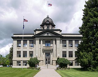
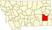
Rosebud County is a county in the state of Montana. It was established February 11, 1901, and has Montana vehicle license plate prefix 29. As of the 2020 census, the population was 8,329. Its county seat is Forsyth.

<span class="mw-page-title-main">Roosevelt County, Montana</span> County in Montana, United States

Roosevelt County is a county in the U.S. state of Montana. As of the 2020 census, the population was 10,794. Its county seat is Wolf Point. Roosevelt County was created by the Montana Legislature in 1919 from a portion of Sheridan County. The name honors former president Theodore Roosevelt, who had died earlier that year.

<span class="mw-page-title-main">Prairie County, Montana</span> County in Montana, United States

Prairie County is a county in the U.S. state of Montana. As of the 2020 census, the population was 1,088, making it the fifth-least populous county in Montana. Its county seat is Terry. Prairie County was created by the Montana Legislature in 1915 out of parts of Custer, Dawson, and Fallon Counties. The name was selected in a contest and reflects the predominant landscape of the region.

<span class="mw-page-title-main">Powder River County, Montana</span> County in Montana, United States

Powder River County is a county in the U.S. state of Montana. As of the 2020 census, the population was 1,694. Its county seat is Broadus.

<span class="mw-page-title-main">Park County, Montana</span> County in Montana, United States

Park County is a county in the U.S. state of Montana. At the 2020 census, the population was 17,191. Its county seat is Livingston. A small part of Yellowstone National Park is in the southern part of the county.

<span class="mw-page-title-main">Fallon County, Montana</span> County in Montana, United States

Fallon County is a county located in the U.S. state of Montana. As of the 2020 census, the population was 3,049. Its county seat is Baker. The county was created in 1913 from a portion of Custer County. It is named for Benjamin O'Fallon, a nephew of Captain William Clark and an Indian agent for the upper Missouri region from 1823 to 1827.

<span class="mw-page-title-main">Carter County, Montana</span> County in Montana, United States

Carter County is a county located in the U.S. state of Montana. As of the 2020 census, the population was 1,415, making it the seventh-least populous county in Montana. The county seat is Ekalaka.

<span class="mw-page-title-main">Custer, Michigan</span> Village in Michigan, United States

Custer is a village in Mason County in the U.S. state of Michigan. The population was 272 at the 2020 census. The village is located within Custer Township.

Manfred Township is a township in Lac qui Parle County, Minnesota, United States. The population was 111 at the 2000 census.

<span class="mw-page-title-main">Pryor, Montana</span> Census-designated place in Montana, United States

Pryor is a census-designated place (CDP) in Big Horn County, Montana, United States. The community is located on Crow Tribe's reservation. The population was 618 at the 2010 census. The area is named for Nathaniel Hale Pryor, a sergeant in the Lewis and Clark Expedition.

<span class="mw-page-title-main">Ekalaka, Montana</span> Town in Montana, United States

Ekalaka is a town in and the county seat of Carter County, Montana, United States. The population was 399 at the 2020 census.

<span class="mw-page-title-main">Cascade, Montana</span> Town in Cascade County, Montana, United States

Cascade is a town in Cascade County, Montana, United States. The population was 600 at the 2020 census. It is part of the Great Falls, Montana Metropolitan Statistical Area, which in 2020 had a population of 84,414. Cascade was incorporated in 1911.

<span class="mw-page-title-main">Custer, Montana</span> Village in Montana, United States

Custer is a village in Yellowstone County, Montana, United States. The population was 145 at the 2000 census.

<span class="mw-page-title-main">Mason City, Nebraska</span> Village in Nebraska, United States

Mason City is a village in Custer County, Nebraska, United States. The population was 171 at the 2010 census.

<span class="mw-page-title-main">Baker, Montana</span> City in Montana, United States

Baker is a city in and the county seat of Fallon County, Montana, United States. The population was 1,802 at the 2020 census.

<span class="mw-page-title-main">Creswell, Oregon</span> City in Oregon, United States

Creswell is a city in the Willamette Valley of Lane County, Oregon, United States, located 13 miles (21 km) south of Eugene, Oregon. The population at the 2010 census was 5,031.

References

  1. 1 2 "State & County QuickFacts". United States Census Bureau. Retrieved April 5, 2023.
  2. "Find a County". National Association of Counties. Archived from the original on May 31, 2011. Retrieved June 7, 2011.
  3. Big Horn County, Montana Territory was not the same county as present day Big Horn County, Montana.
  4. "A Brief Custer County History". Custer County Montana. Archived from the original on October 28, 2014. Retrieved December 1, 2014.
  5. "2010 Census Gazetteer Files". United States Census Bureau. August 22, 2012. Archived from the original on December 5, 2014. Retrieved November 27, 2014.
  6. "U.S. Climate Normals Quick Access". National Oceanic and Atmospheric Administration. Retrieved August 6, 2022.
  7. "NOAA Online Weather Data". National Weather Service. Retrieved August 6, 2022.
  8. "Annual Estimates of the Resident Population for Counties: April 1, 2020 to July 1, 2022". United States Census Bureau. Retrieved April 5, 2023.
  9. "U.S. Decennial Census". United States Census Bureau. Retrieved November 27, 2014.
  10. "Historical Census Browser". University of Virginia Library. Archived from the original on August 11, 2012. Retrieved November 27, 2014.
  11. "Population of Counties by Decennial Census: 1900 to 1990". United States Census Bureau. Retrieved November 27, 2014.
  12. "Census 2000 PHC-T-4. Ranking Tables for Counties: 1990 and 2000" (PDF). United States Census Bureau. Archived (PDF) from the original on March 27, 2010. Retrieved November 27, 2014.
  13. Leip, David. "Atlas of US Presidential Elections". uselectionatlas.org. Retrieved April 2, 2018.
  14. Merrill, Andrea; Judy Jacobson (1997). Montana almanac. Helena MT: Falcon Publishing. ISBN   1-56044-493-2.
  15. 1 2 Montana Dept. of Labor and Industry (September 2010). "Demographic & Economic Information for Custer County" (PDF). Archived from the original (PDF) on September 6, 2011. Retrieved July 23, 2011.
  16. U.S. Geological Survey Geographic Names Information System: Garland
  17. U.S. Geological Survey Geographic Names Information System: Garland
  18. U.S. Geological Survey Geographic Names Information System: Garland
  19. U.S. Geological Survey Geographic Names Information System: Tusler

46°16′N105°35′W / 46.27°N 105.58°W / 46.27; -105.58