Gallatin County, Montana

Last updated

Gallatin County
Looking ENE - Gallatin County Courthouse - Bozeman Montana - 2013-070-09.jpg
Gallatin County Courthouse in Bozeman
Gallatin County seal.gif
Map of Montana highlighting Gallatin County.svg
Location within the U.S. state of Montana
Montana in United States.svg
Montana's location within the U.S.
Coordinates: 45°34′N111°10′W / 45.56°N 111.17°W / 45.56; -111.17
CountryFlag of the United States.svg United States
StateFlag of Montana.svg  Montana
Founded1865
Named for Gallatin River (Albert Gallatin)
Seat Bozeman
Largest cityBozeman
Area
  Total2,632 sq mi (6,820 km2)
  Land2,603 sq mi (6,740 km2)
  Water29 sq mi (80 km2)  1.1%
Population
 (2020)
  Total118,960
  Estimate 
(2022)
124,857 Increase2.svg
  Density45/sq mi (17/km2)
Time zone UTC−7 (Mountain)
  Summer (DST) UTC−6 (MDT)
Congressional district 1st
Website www.gallatin.mt.gov
  • Montana county number 06

Gallatin County is located in the U.S. state of Montana. With its county seat in Bozeman, it is the second-most populous county in Montana, with a population of 118,960 in the 2020 Census. [1]

Contents

The county's prominent geographical features are the Bridger mountains in the north, and the Gallatin mountains and Gallatin River in the south, named by Meriwether Lewis in 1805 for Albert Gallatin, [2] the United States Treasury Secretary who formulated the Lewis and Clark Expedition.

At the southern end of the county, West Yellowstone's entrance into Yellowstone National Park accounts for around half of all park visitors. Big Sky Resort, one of the largest ski resorts in the United States, lies in Gallatin and neighboring Madison counties, midway between Bozeman and West Yellowstone.

History

During the territorial era, a small patch of land known as "Lost Dakota" existed as a remote exclave of Dakota Territory until it was transferred to Gallatin County, Montana Territory, in 1873. [3]

Geography

According to the United States Census Bureau, the county has a total area of 2,632 square miles (6,820 km2), of which 2,603 square miles (6,740 km2) is land and 29 square miles (75 km2) (1.1%) is water. [4] The county attained its present boundaries in 1978, when the former Yellowstone National Park (part) county-equivalent was dissolved and apportioned between Gallatin County and Park County. Gallatin County received 99.155 square miles (256.8 km2) of land area and 0.119 square miles (0.3 km2) of water area, whereas Park County received 146.229 square miles (378.7 km2) of land area and 0.608 square miles (1.6 km2) of water area. The geographies transferred are known now as Census Tract 14 in Gallatin County, and as Census Tract 6 in Park County.

Major highways

Transit

Adjacent counties

National protected areas

Demographics

Historical population
CensusPop.Note
1870 1,578
1880 3,643130.9%
1890 6,24671.5%
1900 9,55352.9%
1910 14,07947.4%
1920 15,86412.7%
1930 16,1241.6%
1940 18,26913.3%
1950 21,90219.9%
1960 26,04518.9%
1970 32,50524.8%
1980 42,86531.9%
1990 50,46317.7%
2000 67,83134.4%
2010 89,51332.0%
2020 118,96032.9%
2022 (est.)124,938 [5] 5.0%
U.S. Decennial Census [6]
1790–1960, [7] 1900–1990, [8]
1990–2000, [9] 2010–2020 [1]

2020 census

As of the 2020 census, there were 118,960 people and 46,990 households living in the county. [10] The population density was 45.2 inhabitants per square mile (17.5/km2). There were 52,835 housing units in the county at an average density of 20.1 per square mile (7.8/km2). [10] The racial make of the county was 89.0% White, 1.2% Asian, 0.9% American Indian, 0.4% Black of African American, 0.1% Pacific Islander, 1.8% from other races, and 6.6% from two or more races. Those of Hispanic of Latino origin made up 5.0% of the population. [11] In terms of ancestry, 25.4% were German, 14.8% were Irish, 12.4% were English, 8.8% were Norwegian, 4.6% were Italian, 4.0% were French, 3.5% were Scottish, 2.2% were Polish and 0.3% were Subsaharan African. [10]

Of the 46,990 households, 48.2% were a Married-couple family household, 23.9% were a "Male householder, no spouse present, family household", and 20.4% were a "Female householder, no spouse present, family household". The averager family size was 2.96 in the county. The median age was 33.1 years old, compared with 40.1 in Montana. [10]

The median income for a household in the county was $75,418 in the county, significantly higher than the $57,153 median household income in all of Montana. 11.9% of the population was below the poverty line, including 6.9% of those under 18 and 6.5% of those over 65.

2010 census

As of the 2010 census, there were 89,513 people, 36,550 households, and 21,263 families living in the county. The population density was 34.4 inhabitants per square mile (13.3/km2). There were 42,289 housing units at an average density of 16.2 per square mile (6.3/km2). The racial makeup of the county was 95.1% White, 1.1% Asian, 0.9% American Indian, 0.3% Black or African American, 0.1% Pacific Islander, 0.7% from other races, and 1.9% from two or more races. Those of Hispanic or Latino origin made up 2.8% of the population. In terms of ancestry, 32.2% were German, 18.1% were Irish, 14.7% were English, 9.4% were Norwegian, and 3.5% were American.

Of the 36,550 households, 27.8% had children under the age of 18 living with them, 47.8% were married couples living together, 6.6% had a female householder with no husband present, 41.8% were non-families, and 27.3% of all households were made up of individuals. The average household size was 2.36 and the average family size was 2.90. The median age was 32.5 years.

The median income for a household in the county was $50,136 and the median income for a family was $65,029. Males had a median income of $42,245 versus $31,349 for females. The per capita income for the county was $27,423. About 7.4% of families and 13.5% of the population were below the poverty line, including 12.5% of those under age 18 and 8.2% of those age 65 or over.

Government and politics

Gallatin County has traditionally favored Republican presidential candidates, often by large margins. Recent changes to Gallatin County's demographics (including migration from Democratic-leaning areas, [12] and younger voters adopting more liberal political positions) [13] have made the county more competitive.

Gallatin County is home to the flagship campus of Montana State University, which contributes to its Democratic lean.

Democratic candidates Barack Obama and Hillary Clinton narrowly won Gallatin County in 2008 and 2016 respectively, with Republican Mitt Romney winning in 2012. 2020 Democratic candidate Joe Biden won Gallatin County by the largest margin for a Democrat since Franklin Delano Roosevelt's victory in 1940.

United States presidential election results for Gallatin County, Montana [14] [15]
Year Republican Democratic Third party
No.%No.%No.%
2020 31,69644.65%37,04452.18%2,2483.17%
2016 23,80244.23%24,24645.05%5,77110.72%
2012 24,35850.84%21,96145.84%1,5893.32%
2008 22,57846.77%24,20550.14%1,4893.08%
2004 22,39256.20%16,40541.18%1,0452.62%
2000 18,83358.78%10,00931.24%3,1989.98%
1996 14,55950.07%10,97237.73%3,54712.20%
1992 11,10938.60%9,53533.13%8,13528.27%
1988 13,21456.94%9,52741.06%4642.00%
1984 15,64364.80%8,16333.82%3341.38%
1980 12,73858.63%5,74726.45%3,24114.92%
1976 11,06263.36%6,21535.60%1831.05%
1972 10,66366.28%5,09631.68%3292.05%
1968 7,43362.06%3,81831.88%7276.07%
1964 5,62149.97%5,60049.79%270.24%
1960 6,87064.49%3,76135.31%210.20%
1956 6,68067.20%3,26032.80%00.00%
1952 6,99871.93%2,69727.72%340.35%
1948 4,22053.08%3,54844.63%1822.29%
1944 3,12047.04%3,47952.46%330.50%
1940 3,43041.84%4,71857.55%500.61%
1936 2,15130.01%4,69765.53%3204.46%
1932 2,55335.98%4,35961.44%1832.58%
1928 3,86161.11%2,42338.35%340.54%
1924 2,49444.35%1,56427.81%1,56527.83%
1920 3,23854.70%2,37040.03%3125.27%
1916 2,52740.07%3,66158.06%1181.87%
1912 68321.07%1,40743.41%1,15135.51%
1908 1,51947.19%1,48546.13%2156.68%
1904 1,70055.77%1,13037.07%2187.15%
1900 1,14645.53%1,29751.53%742.94%
1896 42320.07%1,64978.23%361.71%
1892 99843.32%1,14449.65%1627.03%

Communities

Cities

Towns

Census-designated places

Unincorporated communities

Education

Unified (K-12) districts include: [16]

High school districts include: [16]

Elementary school districts include: [16]

Notable people

See also

Related Research Articles

<span class="mw-page-title-main">Park County, Wyoming</span> County in Wyoming, United States

Park County is a county in the U.S. state of Wyoming. As of the 2020 United States Census, the population was 29,624. The county seat is Cody.

<span class="mw-page-title-main">Yellowstone County, Montana</span> County in Montana, United States

Yellowstone County is the most populous county in the U.S. state of Montana. As of the 2020 census, the population was 164,731. Its county seat is Billings, the state's most populous city. Like the nearby park, Yellowstone County is named after the Yellowstone River which roughly bisects the county, flowing southwest to northeast. The river, in turn, was named for the yellow sandstone cliffs in what is now Yellowstone County.

<span class="mw-page-title-main">Sweet Grass County, Montana</span> County in Montana, United States

Sweet Grass County is a county located in the U.S. state of Montana. As of the 2020 census, the population was 3,678. Its county seat is Big Timber. The county was founded in 1895.

<span class="mw-page-title-main">Park County, Montana</span> County in Montana, United States

Park County is a county in the U.S. state of Montana. At the 2020 census, the population was 17,191. Its county seat is Livingston. A small part of Yellowstone National Park is in the southern part of the county.

<span class="mw-page-title-main">Meagher County, Montana</span> County in Montana, United States

Meagher County is a county located in the U.S. state of Montana. As of the 2020 census, the population was 1,927. Its county seat is White Sulphur Springs.

<span class="mw-page-title-main">Flathead County, Montana</span> County in Montana, United States

Flathead County is in the U.S. state of Montana. At the 2020 census, its population was 104,357, making it the state's fourth most populous county. Its county seat is Kalispell. Its numerical designation is 7. Its northern border is on the state's north border, making it contiguous with the Canada–US border, facing British Columbia.

<span class="mw-page-title-main">Carbon County, Montana</span> County in Montana, United States

Carbon County is a county located in the U.S. state of Montana. As of the 2020 census, the population was 10,473. Its county seat is Red Lodge.

<span class="mw-page-title-main">Belfry, Montana</span> Census-designated place in Montana, United States

Belfry is a census-designated place (CDP) in Carbon County, Montana, United States. It is part of the Billings, Montana Metropolitan Statistical Area. The population was 218 at the 2010 census. It is located approximately 11 miles (18 km) from the Wyoming border, roughly halfway between Billings, Montana and Cody, Wyoming.

<span class="mw-page-title-main">Red Lodge, Montana</span> City in Carbon County, Montana, United States

Red Lodge is a city and county seat of Carbon County, Montana, United States. As of the 2020 census, the population of the city was 2,257.

<span class="mw-page-title-main">Belgrade, Montana</span> City in Montana, United States

Belgrade is a city in Gallatin County, Montana, United States. The population was 10,460 at the 2020 census. Belgrade is part of the Bozeman, MT Micropolitan Statistical Area. It is the most populous city in Montana that is not a county seat.

<span class="mw-page-title-main">Bozeman, Montana</span> City in the United States

Bozeman is a city and the county seat of Gallatin County, Montana, United States. Located in southwest Montana, the 2020 census put Bozeman's population at 53,293 making it the fourth-largest city in Montana. It is the principal city of the Bozeman, Montana, Micropolitan Statistical Area, consisting of all of Gallatin County with a population of 118,960. It is the fastest growing micropolitan statistical area in the United States in 2018, 2019 and 2020, as well as the second-largest of all Montana's statistical areas.

<span class="mw-page-title-main">Four Corners, Montana</span> Census-designated place in Montana, United States

Four Corners is a census-designated place (CDP) in Gallatin County, Montana, United States. The population was 5,901 at the 2020 census, up from 3,146 in 2010. It is part of the Bozeman, MT Micropolitan Statistical Area.

<span class="mw-page-title-main">Manhattan, Montana</span> Town in Montana, United States

Manhattan is a town in Gallatin County, Montana, United States. The population was 2,086 at the 2020 census. It is part of the 'Bozeman Micropolitan Statistical Area'.

<span class="mw-page-title-main">West Yellowstone, Montana</span> Town in Montana, United States

West Yellowstone is a town in Gallatin County, Montana, United States, adjacent to Yellowstone National Park. The population was 1,272 at the 2020 census. West Yellowstone is served by Yellowstone Airport. It is part of the Bozeman, MT Micropolitan Statistical Area.

<span class="mw-page-title-main">Sidney, Montana</span> City in Montana, United States

Sidney is a city in and the county seat of Richland County, Montana, United States, less than 10 mi (16 km) west of the North Dakota border. The population was 6,346 at the 2020 census. The city lies along the Yellowstone River and is in proximity to the badlands of the Dakotas. Sidney is approximately midway between Glendive, Montana and Williston, North Dakota.

<span class="mw-page-title-main">Laurel, Montana</span> City in Montana, United States

Laurel is a city in Yellowstone County, Montana, United States. It is the third largest community in the Billings Metropolitan Statistical Area, and is located in the Yellowstone Valley, as an east–west terminal division point of the BNSF Railway. The population was 7,222 at the 2020 census.

<span class="mw-page-title-main">Shepherd, Montana</span> CDP in Montana, United States

Shepherd is a census-designated place (CDP) in Yellowstone County, Montana, United States. The population was 193 at the 2000 census. Shepherd is a Billings suburb located to the northeast. The unincorporated town was named after R.E. Shepherd, a prominent early settler and owner of the Billings Land and Irrigation Company and the Merchants National Bank. The post office opened in 1915.

<span class="mw-page-title-main">Worden, Montana</span> CDP in Montana, United States

Worden is a census-designated place (CDP) in Yellowstone County, Montana, United States. The population was 582 at the 506 at the 2020 census. Worden, along with Ballantine, Huntley, and Pompey's Pillar, is part of the Huntley Project, an irrigation district established by the United States Bureau of Reclamation in 1907.

<span class="mw-page-title-main">Big Sky, Montana</span> Census-designated place in Montana, United States

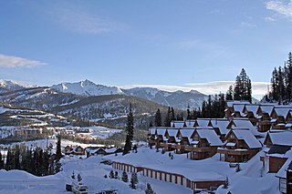
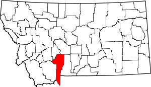
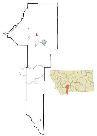
Big Sky is an unincorporated census-designated place (CDP) in Gallatin and Madison counties in southwestern Montana, United States. As of the 2010 census it had a population of 2,308. It is 45 miles (72 km) southwest of Bozeman. This unincorporated community straddles both counties, is not considered a town, and does not have a town government. The primary industry of the area is tourism.

<span class="mw-page-title-main">Amsterdam, Montana</span> CDP in Montana, United States

Amsterdam is a census-designated place (CDP) in Gallatin County, Montana, United States. The population was 206 at the 2020 census. It is part of the Bozeman, MT Micropolitan Statistical Area. It was formerly part of the Amsterdam-Churchill CDP.

References

  1. 1 2 "State & County QuickFacts". United States Census Bureau. Retrieved April 5, 2023.
  2. Gannett, Henry (1905). The Origin of Certain Place Names in the United States. Govt. Print. Off. p. 133.
  3. Beyond 50: American States That Might Have Been : NPR
  4. "2010 Census Gazetteer Files". United States Census Bureau. August 22, 2012. Archived from the original on December 5, 2014. Retrieved November 28, 2014.
  5. "Annual Estimates of the Resident Population for Counties: April 1, 2020 to July 1, 2022". United States Census Bureau. Retrieved April 5, 2023.
  6. "U.S. Decennial Census". United States Census Bureau. Retrieved November 28, 2014.
  7. "Historical Census Browser". University of Virginia Library. Retrieved November 28, 2014.
  8. "Population of Counties by Decennial Census: 1900 to 1990". United States Census Bureau. Retrieved November 28, 2014.
  9. "Census 2000 PHC-T-4. Ranking Tables for Counties: 1990 and 2000" (PDF). United States Census Bureau. Archived (PDF) from the original on March 27, 2010. Retrieved November 28, 2014.
  10. 1 2 3 4 "Explore Census Data". data.census.gov. Retrieved January 23, 2022.
  11. Star, Indianapolis. "Gallatin County, Montana Demographics and Housing 2020 Decennial Census". Indianapolis Star. Retrieved January 23, 2022.
  12. Cohen, Micah (June 21, 2012). "Presidential Geography: Montana". FiveThirtyEight. Retrieved April 2, 2018.
  13. "A wider partisan and ideological gap between younger, older generations". Pew Research Center. March 20, 2017. Retrieved April 2, 2018.
  14. Leip, David. "Atlas of US Presidential Elections". uselectionatlas.org. Retrieved April 2, 2018.
  15. Burnham, Walter Dean. "Presidential ballots, 1836-1892". archive.org. Retrieved January 16, 2021.
  16. 1 2 3 "2020 CENSUS - SCHOOL DISTRICT REFERENCE MAP: Gallatin County, MT" (PDF). U.S. Census Bureau . Retrieved March 13, 2024. - Text list

45°34′N111°10′W / 45.56°N 111.17°W / 45.56; -111.17