Hill County, Montana

Last updated

Hill County
Hill County Courthouse.JPG
Hill County Courthouse in Havre
Map of Montana highlighting Hill County.svg
Location within the U.S. state of Montana
Montana in United States.svg
Montana's location within the U.S.
Coordinates: 48°38′N110°07′W / 48.63°N 110.11°W / 48.63; -110.11
CountryFlag of the United States.svg United States
StateFlag of Montana.svg  Montana
Founded1912
Named for James J. Hill
Seat Havre
Largest cityHavre
Area
  Total2,916 sq mi (7,550 km2)
  Land2,899 sq mi (7,510 km2)
  Water17 sq mi (40 km2)  0.6%
Population
 (2020)
  Total16,309
  Estimate 
(2022)
16,068 Decrease2.svg
  Density5.6/sq mi (2.2/km2)
Time zone UTC−7 (Mountain)
  Summer (DST) UTC−6 (MDT)
Congressional district 2nd
Website hillcounty.us
  • Montana county number 12

Hill County is a county located in the U.S. state of Montana. As of the 2020 census, the population was 16,309. [1] Its county seat is Havre. [2] It lies along the United States border with Canada, abutting Alberta and Saskatchewan.

Contents

Part of its territory is within the Rocky Boy Indian Reservation, which is held by the federally recognized Chippewa-Cree Tribe.

History

The first European-American settlement in the future county area was Fort Assinniboine, garrisoned by the United States Army in 1879. Fifteen of the original 104 structures from the fort are still standing. A portion of the fort was ceded for use as the Indian reservation, which was established in 1916.

The county is named after James J. Hill, president of the Great Northern Railway Company, which built the rail line across Montana as part of the Transcontinental Railroad to the Pacific coast.

Geography

According to the United States Census Bureau, the county has a total area of 2,916 square miles (7,550 km2), of which 2,899 square miles (7,510 km2) is land and 17 square miles (44 km2) (0.6%) is water. [3]

Hill County is on the "Hi-Line" in north-central Montana. It borders Blaine County to the east, Liberty County to the west, and Canada to the north. Hill County contains Beaver Creek Park, the nation's largest county park.

It is one of the few locations in the United States to have an antipodal point on land, and its community of Rudyard is the only populated such place. The Kerguelen Islands are on the opposite side of the earth from parts of Hill County, while the antipodal points of almost all other places in the United States lie in the Indian Ocean.

Adjacent counties and rural municipalities

Major highways

National protected areas

Politics

In presidential elections, Hill County is a swing county. Since 1952, it has voted for the Democratic nominee nine times and the Republican nominee nine times.

United States presidential election results for Hill County, Montana [4] [5]
Year Republican Democratic Third party
No.%No.%No.%
2020 3,95755.10%2,98141.51%2443.40%
2016 3,47853.96%2,37136.79%5969.25%
2012 3,16446.36%3,40349.86%2583.78%
2008 2,78742.07%3,59654.28%2423.65%
2004 3,50552.65%2,99745.02%1552.33%
2000 3,39251.72%2,76042.09%4066.19%
1996 2,60136.58%3,51749.46%99313.96%
1992 2,40829.79%3,61844.77%2,05625.44%
1988 3,46744.50%4,21954.15%1051.35%
1984 4,63555.24%3,65743.59%981.17%
1980 4,44854.99%2,87535.54%7669.47%
1976 3,27445.10%3,87853.42%1081.49%
1972 3,75953.06%3,06143.20%2653.74%
1968 2,97044.53%3,38650.77%3134.69%
1964 2,10131.81%4,49168.00%120.18%
1960 3,16345.73%3,74154.09%120.17%
1956 3,41553.24%2,99946.76%00.00%
1952 3,47455.44%2,74843.86%440.70%
1948 1,64531.75%3,32164.10%2154.15%
1944 1,64635.25%2,98663.95%370.79%
1940 1,84232.79%3,70065.87%751.34%
1936 1,01418.37%4,32878.41%1783.22%
1932 1,58931.44%3,25764.44%2084.12%
1928 2,33653.37%2,02246.20%190.43%
1924 1,11030.60%60216.59%1,91652.81%
1920 2,22055.44%1,38834.67%3969.89%
1916 1,70931.73%3,24160.17%4368.10%
1912 53626.43%62430.77%86842.80%

Demographics

Historical population
CensusPop.Note
1920 13,958
1930 13,775−1.3%
1940 13,304−3.4%
1950 14,2857.4%
1960 18,65330.6%
1970 17,358−6.9%
1980 17,9853.6%
1990 17,654−1.8%
2000 16,673−5.6%
2010 16,096−3.5%
2020 16,3091.3%
2022 (est.)16,068 [6] −1.5%
U.S. Decennial Census [7]
1790–1960, [8] 1900–1990, [9]
1990–2000, [10] 2010–2020 [1]

2020 census

As of the 2020 census, there were 16,309 people living in the county.[ citation needed ]

2010 census

As of the 2010 census, there were 16,096 people, 6,275 households, and 4,020 families living in the county. The population density was 5.6 inhabitants per square mile (2.2/km2). There were 7,250 housing units at an average density of 2.5 per square mile (0.97/km2). The racial makeup of the county was 73.9% white, 21.7% American Indian, 0.4% Asian, 0.3% black or African American, 0.3% from other races, and 3.3% from two or more races. Those of Hispanic or Latino origin made up 2.3% of the population. In terms of ancestry, 28.9% were German, 18.5% were Norwegian, 12.7% were Irish, 9.2% were English, and 3.0% were American.

Of the 6,275 households, 32.5% had children under the age of 18 living with them, 46.3% were married couples living together, 11.9% had a female householder with no husband present, 35.9% were non-families, and 29.8% of all households were made up of individuals. The average household size was 2.47 and the average family size was 3.10. The median age was 35.1 years.

The median income for a household in the county was $43,606 and the median income for a family was $55,963. Males had a median income of $44,286 versus $28,908 for females. The per capita income for the county was $21,420. About 12.4% of families and 17.9% of the population were below the poverty line, including 24.0% of those under age 18 and 9.6% of those age 65 or over.

Communities

City

Town

Census-designated places

Unincorporated communities

See also

Related Research Articles

<span class="mw-page-title-main">Toole County, Montana</span> County in Montana, United States

Toole County is a county in the northern portion of the U.S. state of Montana. As of the 2020 census, the population was 4,971. Its county seat is Shelby. The county was established in 1914 from parts of Hill County and Teton County and was named after Joseph Toole, the first and fourth governor of Montana. Its northern boundary is the Canada–United States border south of Alberta.

<span class="mw-page-title-main">Teton County, Montana</span> County in Montana, United States

Teton County is a county in the U.S. state of Montana. As of the 2020 census, the population was 6,226. Its county seat is Choteau. The county was founded in 1893.

<span class="mw-page-title-main">Ravalli County, Montana</span> County in Montana, United States

Ravalli County is a county in the southwestern part of the U.S. state of Montana. As of the 2020 census, the population was 44,174. Its county seat is Hamilton.

<span class="mw-page-title-main">Mineral County, Montana</span> County in Montana, United States

Mineral County is a county located in the U.S. state of Montana. As of the 2020 census, the population was 4,535. Its county seat is Superior.

<span class="mw-page-title-main">Liberty County, Montana</span> County in Montana, United States

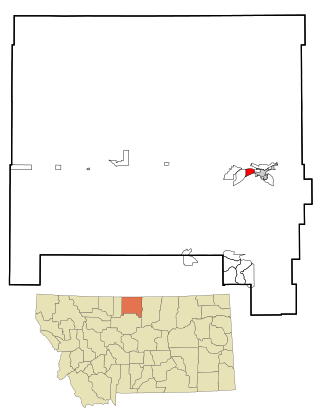
Liberty County is a county located in the U.S. state of Montana. As of the 2020 census, the population was 1,959. Its county seat is Chester. The decision to separate the future Liberty County area from the previous Hill and Chouteau counties was carried in a 1919 vote; the organization was authorized to commence in the following February.

<span class="mw-page-title-main">Jefferson County, Montana</span> County in Montana, United States

Jefferson County is a county in Montana, United States. As of the 2020 census, the population was 12,085. Its county seat is Boulder. The county was created in 1865 and named for President Thomas Jefferson.

<span class="mw-page-title-main">Golden Valley County, Montana</span> County in Montana, United States

Golden Valley County is a county located in the U.S. state of Montana. As of the 2020 census, the population was 823, making it the third-least populous county in Montana. Its county seat is Ryegate.

<span class="mw-page-title-main">Fallon County, Montana</span> County in Montana, United States

Fallon County is a county located in the U.S. state of Montana. As of the 2020 census, the population was 3,049. Its county seat is Baker. The county was created in 1913 from a portion of Custer County. It is named for Benjamin O'Fallon, a nephew of Captain William Clark and an Indian agent for the upper Missouri region from 1823 to 1827.

<span class="mw-page-title-main">Chouteau County, Montana</span> County in Montana, United States

Chouteau County is a county located in the North-Central region of the U.S. state of Montana. As of the 2020 census, the population was 5,895. Its county seat is Fort Benton. The county was established in 1865 as one of the original nine counties of Montana, and named in 1882 after Pierre Chouteau Jr., a fur trader who established a trading post that became Fort Benton, which was once an important port on the Missouri River.

<span class="mw-page-title-main">Carter County, Montana</span> County in Montana, United States

Carter County is a county located in the U.S. state of Montana. As of the 2020 census, the population was 1,415, making it the seventh-least populous county in Montana. The county seat is Ekalaka.

<span class="mw-page-title-main">Gildford, Montana</span> Census-designated place in Montana, United States

Gildford is an unincorporated community and census-designated place (CDP) in Hill County, Montana, United States. The population was 179 at the 2010 census.

<span class="mw-page-title-main">Havre North, Montana</span> Census-designated place in Montana, United States

Havre North is a census-designated place (CDP) in Hill County, Montana, United States. The population was 716 at the 2010 census, down from 973 in 2000.

<span class="mw-page-title-main">Herron, Montana</span> Census-designated place in Montana, United States

Herron is a census-designated place (CDP) in Hill County, Montana, United States. The population was 43 at the 2010 census.

<span class="mw-page-title-main">Hingham, Montana</span> Town in Montana, United States

Hingham is a town in Hill County, Montana, United States. Its economy is largely agricultural. The population was 131 at the 2020 census.

<span class="mw-page-title-main">Kremlin, Montana</span> Census-designated place in Montana, United States

Kremlin is an unincorporated community and census-designated place (CDP) in Hill County, Montana, United States. The population was 98 at the 2010 census, down from 126 in 2000.

<span class="mw-page-title-main">Rudyard, Montana</span> Census-designated place in Montana, United States

Rudyard is an unincorporated community and census-designated place (CDP) in Hill County, Montana, United States. The population was 258 at the 2010 census.

<span class="mw-page-title-main">West Havre, Montana</span> Census-designated place in Montana, United States

West Havre is a census-designated place (CDP) in Hill County, Montana, United States. The population was 316 at the 2010 census, up from 284 in 2000.

<span class="mw-page-title-main">Ravalli, Montana</span> Place in Montana, United States

Ravalli is an unincorporated community in Lake County, Montana, United States. The population was 76 at the 2010 census, down from 119 in 2000. For statistical purposes, the United States Census Bureau has defined Ravalli as a census-designated place (CDP). In the early 1900s, the Pablo-Allard herd in Ravalli was said to be the largest collection of the bison remaining in the U.S. and played a critical role in the conservation of bison.

<span class="mw-page-title-main">Chester, Montana</span> Town in Montana, United States

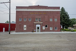
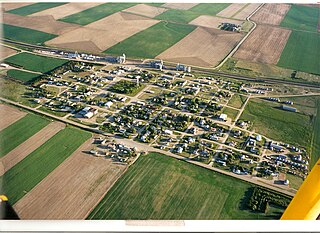
Chester is a town in and the county seat of Liberty County, Montana, United States. The population was 847 at the time of both the 2010 and 2020 U.S. Census.

<span class="mw-page-title-main">Joplin, Montana</span> Unincorporated community in Montana, United States

Joplin is an unincorporated community and census-designated place (CDP) in Liberty County, Montana, United States. The population was 157 at the 2010 census.

References

  1. 1 2 "State & County QuickFacts". United States Census Bureau. Retrieved May 7, 2022.
  2. "Find a County". National Association of Counties. Archived from the original on May 31, 2011. Retrieved June 7, 2011.
  3. "2010 Census Gazetteer Files". United States Census Bureau. August 22, 2012. Archived from the original on December 5, 2014. Retrieved November 28, 2014.
  4. Leip, David. "Atlas of US Presidential Elections". uselectionatlas.org. Retrieved April 3, 2018.
  5. The leading "other" candidate, Progressive Theodore Roosevelt, received 545 votes, while Socialist candidate Eugene Debs received 323 votes.
  6. "Annual Estimates of the Resident Population for Counties: April 1, 2020 to July 1, 2022". United States Census Bureau. Retrieved May 7, 2023.
  7. "U.S. Decennial Census". United States Census Bureau. Retrieved November 28, 2014.
  8. "Historical Census Browser". University of Virginia Library. Retrieved November 28, 2014.
  9. "Population of Counties by Decennial Census: 1900 to 1990". United States Census Bureau. Retrieved November 28, 2014.
  10. "Census 2000 PHC-T-4. Ranking Tables for Counties: 1990 and 2000" (PDF). United States Census Bureau. Retrieved November 28, 2014.
  11. Agency, Hill County MT Google Maps (accessed January 2, 2019)
  12. Goldstone, Hill County MT Google Maps (accessed January 2, 2019)
  13. Simpson, Hill County MT Google Maps (accessed January 2, 2019)

48°38′N110°07′W / 48.63°N 110.11°W / 48.63; -110.11