Lincoln County, Montana

Last updated

Lincoln County
Lincoln County Courthouse July 2020.jpg
Lincoln County Courthouse
Map of Montana highlighting Lincoln County.svg
Location within the U.S. state of Montana
Montana in United States.svg
Montana's location within the U.S.
Coordinates: 48°32′N115°25′W / 48.54°N 115.41°W / 48.54; -115.41
CountryFlag of the United States.svg United States
StateFlag of Montana.svg  Montana
FoundedMarch 9, 1909 [1]
Named for Abraham Lincoln
Seat Libby
Largest cityLibby
Area
  Total3,675 sq mi (9,520 km2)
  Land3,613 sq mi (9,360 km2)
  Water62 sq mi (160 km2)  1.7%
Population
 (2020)
  Total19,677
  Estimate 
(2022)
21,525 Increase2.svg
  Density5.4/sq mi (2.1/km2)
Time zone UTC−7 (Mountain)
  Summer (DST) UTC−6 (MDT)
Congressional district 1st
Website www.lincolncountymt.us
  • Montana county number 56,
    the highest county number

Lincoln County is a county located in the U.S. state of Montana. As of the 2020 census, the population was 19,677. [2] Its county seat is Libby. [3] The county was founded in 1909 and named for President Abraham Lincoln. The county lies on Montana's north border and thus shares the US-Canadian border with the Canadian province of British Columbia.

Contents

This heavily wooded and mountainous county once was part of Flathead County until residents of Libby and Eureka petitioned the state legislature for separation. Libby won an election over Eureka to host the county seat.

Geography

According to the United States Census Bureau, the county has a total area of 3,675 square miles (9,520 km2), of which 3,615 square miles (9,360 km2) is land and 62 square miles (160 km2) (1.7%) is water. [4] The county borders the Canadian province of British Columbia to the north. The lowest point in the state of Montana is located on the Kootenai River in Lincoln County, where it flows out of Montana and into Idaho. Upstream, Libby Dam backs up huge Lake Koocanusa (combination name of Kootenai, Canada, USA) into Canada's British Columbia.

Adjacent counties and county-equivalents

National protected areas

Economics

Top employers

In 2003, the top employers are listed in the table below. [5]

#Employer# of Employees
1 Kootenai National Forest 276
2Libby Public School District203
3St John's Lutheran Hospital182
4Lincoln County Government135
5Owens & Hurst Lumber120

Demographics

Historical population
CensusPop.Note
1910 3,638
1920 7,797114.3%
1930 7,089−9.1%
1940 7,88211.2%
1950 8,69310.3%
1960 12,53744.2%
1970 18,06344.1%
1980 17,752−1.7%
1990 17,481−1.5%
2000 18,8377.8%
2010 19,6874.5%
2020 19,677−0.1%
2022 (est.)21,525 [6] 9.4%
U.S. Decennial Census [7]
1790–1960 [8] 1900–1990 [9]
1990–2000 [10] 2010–2020 [2]

2020 census

As of the 2020 census, there were 19,677 people living in the county.[ citation needed ]

2010 census

As of the 2010 census, there were 19,687 people, 8,843 households, and 5,608 families living in the county. The population density was 5.4 inhabitants per square mile (2.1/km2). There were 11,413 housing units at an average density of 3.2 units per square mile (1.2 units/km2). The racial makeup of the county was 95.9% white, 0.9% American Indian, 0.3% Asian, 0.1% black or African American, 0.4% from other races, and 2.3% from two or more races. Those of Hispanic or Latino origin made up 2.3% of the population. In terms of ancestry, 31.5% were German, 15.7% were Irish, 15.3% were English, 10.2% were Norwegian, and 3.3% were American.

Of the 8,843 households, 23.2% had children under the age of 18 living with them, 52.0% were married couples living together, 7.4% had a female householder with no husband present, 36.6% were non-families, and 30.6% of all households were made up of individuals. The average household size was 2.20 and the average family size was 2.72. The median age was 48.9 years.

The median income for a household in the county was $30,823 and the median income for a family was $39,600. Males had a median income of $40,944 versus $24,965 for females. The per capita income for the county was $19,626. About 13.7% of families and 18.6% of the population were below the poverty line, including 28.2% of those under age 18 and 12.1% of those age 65 or over.

Communities

Welcome sign for Lincoln County on U.S. Route 93 Lincoln County Montana Sign US93.jpg
Welcome sign for Lincoln County on U.S. Route 93

Cities

Towns

Census-designated places

Other unincorporated communities

Politics

For its first eighty years, Lincoln County was a Democratic-leaning area that would vote Republican only during large GOP landslides. Only four Republicans were to win the county in the seventeen Presidential elections between its inaugural election in 1912 and 1976. However, like many timber-dependent counties, it has become overwhelmingly Republican since that time. The last Democrat to carry Lincoln County was Michael Dukakis during the drought-influenced 1988 election. Since then, no Democrat has reached 35 percent of the county's vote.

United States presidential election results for Lincoln County, Montana [16]
Year Republican Democratic Third party
No.%No.%No.%
2020 8,67273.81%2,83524.13%2422.06%
2016 6,72972.12%2,04121.88%5606.00%
2012 6,05768.13%2,55228.71%2813.16%
2008 5,70461.82%3,02532.78%4985.40%
2004 5,88969.70%2,32027.46%2402.84%
2000 5,57871.09%1,62920.76%6398.14%
1996 3,55245.16%2,70534.39%1,60920.46%
1992 2,79933.41%2,76533.00%2,81433.59%
1988 3,50047.98%3,60149.37%1932.65%
1984 4,08056.79%2,95941.19%1452.02%
1980 4,20257.19%2,42232.96%7249.85%
1976 3,01748.02%3,14650.07%1201.91%
1972 3,27652.77%2,40238.69%5308.54%
1968 2,35540.55%2,67746.10%77513.35%
1964 1,55433.00%3,14066.68%150.32%
1960 1,90241.84%2,62357.70%210.46%
1956 2,32150.38%2,28649.62%00.00%
1952 1,88149.23%1,90749.91%330.86%
1948 1,07937.30%1,68958.38%1254.32%
1944 1,10942.84%1,44555.81%351.35%
1940 1,25036.25%2,15062.35%481.39%
1936 74524.43%2,11769.41%1886.16%
1932 83328.66%1,86764.25%2067.09%
1928 1,21752.30%1,06745.85%431.85%
1924 97640.89%37415.67%1,03743.44%
1920 1,18757.54%68333.11%1939.36%
1916 80735.35%1,18651.95%29012.70%
1912 21821.69%34634.43%44143.88%

See also

Notes

    Related Research Articles

    <span class="mw-page-title-main">Valley County, Montana</span> County in Montana, United States

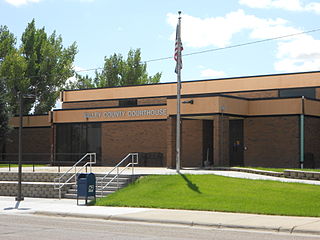
    Valley County is a county in the U.S. state of Montana. Valley County was created in 1893 with area partitioned from Dawson County. As of the 2020 census, the population was 7,578. Its county seat is Glasgow. It is located on the Canada–United States border with Saskatchewan.

    <span class="mw-page-title-main">Toole County, Montana</span> County in Montana, United States

    Toole County is a county in the northern portion of the U.S. state of Montana. As of the 2020 census, the population was 4,971. Its county seat is Shelby. The county was established in 1914 from parts of Hill County and Teton County and was named after Joseph Toole, the first and fourth governor of Montana. Its northern boundary is the Canada–United States border south of Alberta.

    <span class="mw-page-title-main">Teton County, Montana</span> County in Montana, United States

    Teton County is a county in the U.S. state of Montana. As of the 2020 census, the population was 6,226. Its county seat is Choteau. The county was founded in 1893.

    <span class="mw-page-title-main">Sanders County, Montana</span> County in Montana, United States

    Sanders County is a county in the U.S. state of Montana. As of the 2020 census, the population was 12,400. Its county seat is Thompson Falls. The county was founded in 1905.

    <span class="mw-page-title-main">Ravalli County, Montana</span> County in Montana, United States

    Ravalli County is a county in the southwestern part of the U.S. state of Montana. As of the 2020 census, the population was 44,174. Its county seat is Hamilton.

    <span class="mw-page-title-main">Powell County, Montana</span> County in Montana, United States

    Powell County is a county in the U.S. state of Montana. As of the 2020 census, the population was 6,946. Its county seat is Deer Lodge.

    <span class="mw-page-title-main">Pondera County, Montana</span> County in Montana, United States

    Pondera County is a county in the U.S. state of Montana. As of the 2020 census, the population was 5,898. Its county seat is Conrad.

    <span class="mw-page-title-main">Phillips County, Montana</span> County in Montana, United States

    Phillips County is a county in the U.S. state of Montana. As of the 2020 census, the population was 4,217. Its county seat is Malta. Before February 5, 1915, Phillips County was part of Blaine County, and before 1912 both were part of Chouteau County. It was named for rancher and state senator Benjamin D. Phillips.

    <span class="mw-page-title-main">Lewis and Clark County, Montana</span> County in Montana, United States

    Lewis and Clark County is a county located in the U.S. state of Montana. As of the 2020 census, the population was 70,973. Its county seat is Helena, the state capital. The numerical designation for Lewis and Clark County is 5. The county was established on June 2, 1865, as one of the nine original counties of the Territory of Montana named Edgerton County in honor of Sidney Edgerton, first Governor of the Territory of Montana, and was renamed Lewis and Clark County on March 1, 1868, in honor of explorers Meriwether Lewis and William Clark.

    <span class="mw-page-title-main">Jefferson County, Montana</span> County in Montana, United States

    Jefferson County is a county in Montana, United States. As of the 2020 census, the population was 12,085. Its county seat is Boulder. The county was created in 1865 and named for President Thomas Jefferson.

    <span class="mw-page-title-main">Flathead County, Montana</span> County in Montana, United States

    Flathead County is in the U.S. state of Montana. At the 2020 census, its population was 104,357, making it the state's fourth most populous county. Its county seat is Kalispell. Its numerical designation is 7. Its northern border is on the state's north border, making it contiguous with the Canada–US border, facing British Columbia.

    <span class="mw-page-title-main">Daniels County, Montana</span> County in Montana, United States

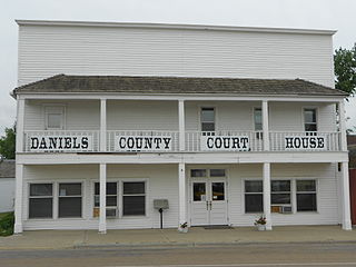
    Daniels County is a county located in the U.S. state of Montana. As of the 2020 census, the population was 1,661. Its county seat is Scobey. It is on Montana's north border, and thus abuts the Canada–US border with Saskatchewan.

    <span class="mw-page-title-main">Bonners Ferry, Idaho</span> City in Idaho

    Bonners Ferry is the largest of two cities in and the county seat of Boundary County, Idaho, United States. The population was 2,543 at the 2010 census.

    <span class="mw-page-title-main">Fortine, Montana</span> Census-designated place in Montana, United States

    Fortine is a census-designated place (CDP) in Lincoln County, Montana, United States. The population was 206 at the 2021 census.

    <span class="mw-page-title-main">Rexford, Montana</span> Town in Montana, United States

    Rexford is a town in Lincoln County, Montana, United States. The population was 78 at the 2020 census.

    <span class="mw-page-title-main">Troy, Montana</span> City in Montana, United States

    Troy is a city in Lincoln County, Montana, United States. The population was 797 at the 2020 census. It lies at the lowest elevation of any settlement in Montana. The town is on U.S. Route 2, near Montana Highway 56, in the Kootenai River gorge by the Kootenai National Forest.

    <span class="mw-page-title-main">Arlee, Montana</span> Census-designated place in Montana, United States

    Arlee is an unincorporated community and census-designated place (CDP) on the Flathead Reservation, Lake County, Montana, United States. The population was 725 at the 2020 census. It is named after Alee, a Salish chief. The chief's name has no "r", as the Salish alphabet has no letter "r".

    <span class="mw-page-title-main">Dayton, Montana</span> Census-designated place in Montana, United States

    Dayton is an unincorporated community and census-designated place (CDP) in Lake County, Montana, United States. The population was 84 at the 2010 census.

    <span class="mw-page-title-main">Eureka, Montana</span> Town in Montana, United States

    Eureka is a town in Lincoln County, Montana, United States, 9 miles (14 km) south of the Canada–US border. The population was 1,380 at the 2020 census.

    <span class="mw-page-title-main">Libby, Montana</span> City in Montana, United States

    Libby is a city in northwestern Montana, United States and the county seat of Lincoln County. The population was 2,775 at the 2020 census.

    References

    1. "Montana County Formation Table". genealogytrails.com. Retrieved April 3, 2018.
    2. 1 2 "State & County QuickFacts". United States Census Bureau. Retrieved May 7, 2023.
    3. "Find a County". National Association of Counties. Retrieved June 7, 2011.
    4. "2010 Census Gazetteer Files". U.S. Census Bureau. August 22, 2012. Archived from the original on December 5, 2014. Retrieved November 28, 2014.
    5. "Community Information - Employment by Industry Chart - Lincoln County, Montana". libbymt.com. Retrieved August 18, 2020.
    6. "Annual Estimates of the Resident Population for Counties: April 1, 2020 to July 1, 2022". United States Census Bureau. Retrieved May 7, 2023.
    7. "U.S. Decennial Census". United States Census Bureau. Retrieved November 28, 2014.
    8. "Historical Census Browser". University of Virginia Library. Retrieved November 28, 2014.
    9. "Population of Counties by Decennial Census: 1900 to 1990". United States Census Bureau. Retrieved November 28, 2014.
    10. "Census 2000 PHC-T-4. Ranking Tables for Counties: 1990 and 2000" (PDF). United States Census Bureau. Archived (PDF) from the original on March 27, 2010. Retrieved November 28, 2014.
    11. Dodge Summit MT Google Maps (accessed January 3, 2019)
    12. Jennings MT Google Maps (accessed January 3, 2019)
    13. Kootenai Falls MT Google Maps (accessed January 3, 2019)
    14. Tobacco MT Google Maps (accessed January 3, 2019)
    15. Yarnell MT Google Maps (accessed January 3, 2019)
    16. Leip, David. "Atlas of US Presidential Elections". uselectionatlas.org. Retrieved April 3, 2018.

    48°32′N115°25′W / 48.54°N 115.41°W / 48.54; -115.41