Sweet Grass County, Montana

Last updated

Sweet Grass County
Carneige Library Big Timber Montana 02.JPG
Map of Montana highlighting Sweet Grass County.svg
Location within the U.S. state of Montana
Montana in United States.svg
Montana's location within the U.S.
Coordinates: 45°49′N109°56′W / 45.81°N 109.94°W / 45.81; -109.94
CountryFlag of the United States.svg United States
StateFlag of Montana.svg  Montana
Founded1895
Named for Sweet grass
Seat Big Timber
Largest cityBig Timber
Area
  Total1,862 sq mi (4,820 km2)
  Land1,855 sq mi (4,800 km2)
  Water6.8 sq mi (18 km2)  0.4%
Population
 (2020)
  Total3,678
  Estimate 
(2022)
3,715 Increase2.svg
  Density2.0/sq mi (0.76/km2)
Time zone UTC−7 (Mountain)
  Summer (DST) UTC−6 (MDT)
Congressional district 2nd
Website sweetgrasscountygov.com
  • Montana county number 40

Sweet Grass County is a county located in the U.S. state of Montana. As of the 2020 census, the population was 3,678. [1] Its county seat is Big Timber. [2] The county was founded in 1895. [3]

Contents

History

The Montana Legislature authorized Sweet Grass County in 1895, taking parts of Park, Meagher, and Yellowstone counties. That boundary was altered in 1913 when Stillwater County was formed from a portion of Sweet Grass; again in 1917 with the formation of Wheatland County, and in 1920 with the formation of Golden Valley County. [4]

Climate

Sweet Grass County's climate is generally dry and cool, specified as Dfc in the Köppen-Geiger climate classification (subarctic or boreal). [5] Average annual precipitation of 15 inches (380 mm) comes in rain and snow. The summer precipitation accumulation (April through September) averages 10.5 inches (270 mm). The average summer high temperature is 75.3 °F (24.1 °C) and the average minimum temperature during that period is 44.2 °F (6.8 °C). July and August are the hottest months. The annual average high temperature is 60.6 °F (15.9 °C) and the annual average minimum temperature is 33.6 °F (0.9 °C). The coldest temperature recorded in the county in recent times was −47 °F (−44 °C) in February 1936, and the warmest was 107 °F (42 °C) in July 2002. Big Timber receives 286 sunny days on average. [4]

Geography

According to the United States Census Bureau, the county has a total area of 1,862 square miles (4,820 km2), of which 1,855 square miles (4,800 km2) is land and 6.8 square miles (18 km2) (0.4%) is water. [6]

Major highways

Transit

Adjacent counties

National protected areas

Demographics

Historical population
CensusPop.Note
1900 3,086
1910 4,02930.6%
1920 4,92622.3%
1930 3,944−19.9%
1940 3,719−5.7%
1950 3,621−2.6%
1960 3,290−9.1%
1970 2,980−9.4%
1980 3,2167.9%
1990 3,154−1.9%
2000 3,60914.4%
2010 3,6511.2%
2020 3,6780.7%
2022 (est.)3,715 [7] 1.0%
U.S. Decennial Census [8]
1790–1960, [9] 1900–1990, [10]
1990–2000, [11] 2010–2020 [1]

2020 census

As of the 2020 census, there were 3,678 people living in the county.[ citation needed ]

2010 census

As of the 2010 census, there were 3,651 people, 1,590 households, and 1,045 families in the county. The population density was 2.0 people per square mile (0.77 people/km2). There were 2,148 housing units at an average density of 1.2 units per square mile (0.46/km2). The racial makeup of the county was 96.6% white, 0.7% Asian, 0.4% American Indian, 0.1% black or African American, 0.6% from other races, and 1.5% from two or more races. Those of Hispanic or Latino origin made up 1.4% of the population. In terms of ancestry, 25.3% were German, 22.6% were Norwegian, 13.0% were American, 12.8% were Irish, 10.8% were English, and 7.3% were Scottish.

Of the 1,590 households, 28.3% had children under the age of 18 living with them, 56.2% were married couples living together, 6.5% had a female householder with no husband present, 34.3% were non-families, and 30.4% of all households were made up of individuals. The average household size was 2.27 and the average family size was 2.82. The median age was 46.6 years.

The median income for a household in the county was $43,723 and the median income for a family was $56,552. Males had a median income of $35,385 versus $25,000 for females. The per capita income for the county was $22,785. About 10.0% of families and 12.1% of the population were below the poverty line, including 17.8% of those under age 18 and 9.9% of those age 65 or over.

Politics

In presidential elections, Sweet Grass County is among the most consistently Republican counties in the state or nation. The last, and one of the only, times the Democratic candidate carried the county was in 1936 when Franklin D. Roosevelt won every county in Montana. In both the 1916 and 1932 Presidential elections Sweet Grass County was the only county in Montana to be won by the Republican. [12]

Sweet Grass County is also Republican at a local level. Democratic governor Brian Schweitzer has never won a majority of the county's vote and no Democratic gubernatorial candidate has carried the county in decades. [13] In the Montana Senate it is represented by Republican Nels Swandal and in the Montana House of Representatives it is represented by Republican Alan Redfield. [14]

United States presidential election results for Sweet Grass County, Montana [15]
Year Republican Democratic Third party
No.%No.%No.%
2020 1,84075.22%54922.44%572.33%
2016 1,59575.70%40219.08%1105.22%
2012 1,59475.30%47522.44%482.27%
2008 1,49471.72%54125.97%482.30%
2004 1,50976.10%44522.44%291.46%
2000 1,45078.55%30516.52%914.93%
1996 1,10962.23%46926.32%20411.45%
1992 88048.86%39521.93%52629.21%
1988 1,24271.67%46226.66%291.67%
1984 1,41778.59%37820.97%80.44%
1980 1,16967.22%44025.30%1307.48%
1976 1,13568.41%50230.26%221.33%
1972 1,26076.00%35021.11%482.90%
1968 1,04370.00%33622.55%1117.45%
1964 85656.54%65343.13%50.33%
1960 1,09667.78%52132.22%00.00%
1956 1,12971.28%45528.72%00.00%
1952 1,31577.17%37221.83%171.00%
1948 84361.71%49936.53%241.76%
1944 89762.29%53337.01%100.69%
1940 86153.45%74146.00%90.56%
1936 66443.01%78350.71%976.28%
1932 78449.18%76147.74%493.07%
1928 1,16372.46%43527.10%70.44%
1924 85359.57%24817.32%33123.11%
1920 1,03573.51%34924.79%241.70%
1916 89050.20%83947.32%442.48%
1912 18119.21%27729.41%48451.38%
1908 52663.76%26432.00%354.24%
1904 53870.51%17422.80%516.68%

Culture

The county was the setting of the 2009 sheep-herding documentary Sweetgrass . The film takes place in many counties in Montana but the title comes from this county.

Communities

City

Census-designated place

Unincorporated communities

See also

Related Research Articles

<span class="mw-page-title-main">Wheatland County, Montana</span> County in Montana, United States

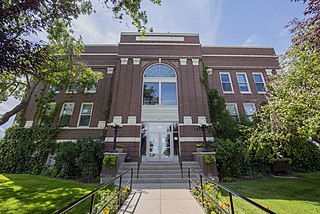
Wheatland County is a county in the U.S. state of Montana. As of the 2020 census, the population was 2,069. Its county seat is Harlowton. Wheatland County was established on February 22, 1917, with areas partitioned from Meagher and Sweet Grass counties. It was named for the abundant wheat-growing areas across the center portion of the new county's area.

<span class="mw-page-title-main">Treasure County, Montana</span> County in Montana, United States

Treasure County is a county in the U.S. state of Montana. As of the 2020 census, the population was 762, making it the second-least populous county in Montana. Its county seat is Hysham. The county was founded in 1919.

<span class="mw-page-title-main">Toole County, Montana</span> County in Montana, United States

Toole County is a county in the northern portion of the U.S. state of Montana. As of the 2020 census, the population was 4,971. Its county seat is Shelby. The county was established in 1914 from parts of Hill County and Teton County and was named after Joseph Toole, the first and fourth governor of Montana. Its northern boundary is the Canada–United States border south of Alberta.

<span class="mw-page-title-main">Stillwater County, Montana</span> County in Montana, United States

Stillwater County is a county in the U.S. state of Montana. As of the 2020 census, the population was 8,963. Its county seat is Columbus.

<span class="mw-page-title-main">Roosevelt County, Montana</span> County in Montana, United States

Roosevelt County is a county in the U.S. state of Montana. As of the 2020 census, the population was 10,794. Its county seat is Wolf Point. Roosevelt County was created by the Montana Legislature in 1919 from a portion of Sheridan County. The name honors former president Theodore Roosevelt, who had died earlier that year.

<span class="mw-page-title-main">Park County, Montana</span> County in Montana, United States

Park County is a county in the U.S. state of Montana. At the 2020 census, the population was 17,191. Its county seat is Livingston. A small part of Yellowstone National Park is in the southern part of the county.

<span class="mw-page-title-main">Meagher County, Montana</span> County in Montana, United States

Meagher County is a county located in the U.S. state of Montana. As of the 2020 census, the population was 1,927. Its county seat is White Sulphur Springs.

<span class="mw-page-title-main">Judith Basin County, Montana</span> County in Montana, United States

Judith Basin County is a county in the U.S. state of Montana. As of the 2020 census, the population was 2,023. Its county seat is the town of Stanford.

<span class="mw-page-title-main">Golden Valley County, Montana</span> County in Montana, United States

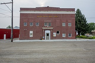
Golden Valley County is a county located in the U.S. state of Montana. As of the 2020 census, the population was 823, making it the third-least populous county in Montana. Its county seat is Ryegate.

<span class="mw-page-title-main">Garfield County, Montana</span> County in Montana, United States

Garfield County is a county located in the U.S. state of Montana. As of the 2020 census, the population was 1,173. Its county seat is Jordan.

<span class="mw-page-title-main">Fergus County, Montana</span> County in Montana, United States

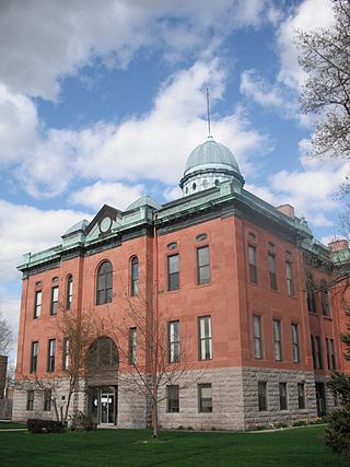
Fergus County is a county in the U.S. state of Montana. As of the 2020 census, the population was 11,446. Its county seat is Lewistown. The county was founded in 1885 and named for James Fergus, a Montana politician who was instrumental in creating the county.

<span class="mw-page-title-main">Broadwater County, Montana</span> County in Montana, United States

Broadwater County is a county in the U.S. state of Montana. As of the 2020 census, the population was 6,774. Its county seat is Townsend. The county was named for Charles Arthur Broadwater, a noted Montana railroad, real estate, and banking magnate.

<span class="mw-page-title-main">Big Horn County, Montana</span> County in Montana, United States

Big Horn County is a county located in the U.S. state of Montana. As of the 2020 census, the population was 13,124. The county seat is Hardin. The county, like the river and the mountain range, is named after the bighorn sheep in the Rocky Mountains. The county was founded in 1913. It is located on the south line of the state.

<span class="mw-page-title-main">Scott County, Iowa</span> County in Iowa, United States

Scott County is a county located in the U.S. state of Iowa. As of the 2020 census, the population was 174,669, making it the third-most populous county in Iowa. The county seat is Davenport.

<span class="mw-page-title-main">Menard County, Illinois</span> County in Illinois, United States

Menard County is a county in the U.S. state of Illinois. According to the 2020 United States Census, it had a population of 12,297. Its county seat is Petersburg. Menard County is part of the Springfield, Illinois, IL Metropolitan Statistical Area.

<span class="mw-page-title-main">Wheatland, California</span> City in California, United States

Wheatland is the second-largest city by population in Yuba County, California, United States. The population was 3,456 at the 2010 census, up from 2,275 at the 2000 census. Wheatland is located 12.5 miles (20 km) southeast of Marysville.

<span class="mw-page-title-main">Wheatland, Iowa</span> City in Iowa, United States

Wheatland is a city in Clinton County, Iowa, United States. The population was 775 at the time of the 2020 census.

<span class="mw-page-title-main">Loma, Montana</span> Census-designated place in Montana, United States

Loma is a census-designated place (CDP) in Chouteau County, Montana, United States. The population was 85 at the 2010 census.

<span class="mw-page-title-main">Big Timber, Montana</span> City in Montana, United States

Big Timber is a city in, and the county seat of Sweet Grass County, Montana, United States. The population was 1,650 at the 2020 census.

<span class="mw-page-title-main">Petroleum County, Montana</span> County in Montana, United States

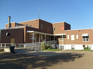
Petroleum County is a county in the U.S. state of Montana. As of the 2020 census, the population was 496, making it the least populous county in Montana and the eighth-least populous in the United States. Its county seat is Winnett. The county's area was partitioned from Fergus County in 1925 to become the last of Montana's 56 counties to be organized.

References

  1. 1 2 "State & County QuickFacts". United States Census Bureau. Retrieved May 8, 2023.
  2. "Find a County". National Association of Counties. Retrieved June 7, 2011.
  3. Montana Place Names from Alzada to Zortman. Helena, MT: Montana Historical Society Press. 2009. p. 259.
  4. 1 2 About Sweet Grass County (accessed January 7, 2019)
  5. Koeppen-Geiger Classification for US counties (accessed January 7, 2019)
  6. "2010 Census Gazetteer Files". United States Census Bureau. August 22, 2012. Archived from the original on December 5, 2014. Retrieved November 30, 2014.
  7. "Annual Estimates of the Resident Population for Counties: April 1, 2020 to July 1, 2022". United States Census Bureau. Retrieved May 8, 2023.
  8. "U.S. Decennial Census". United States Census Bureau. Retrieved November 30, 2014.
  9. "Historical Census Browser". University of Virginia Library. Retrieved November 30, 2014.
  10. "Population of Counties by Decennial Census: 1900 to 1990". United States Census Bureau. Retrieved November 30, 2014.
  11. "Census 2000 PHC-T-4. Ranking Tables for Counties: 1990 and 2000" (PDF). United States Census Bureau. Archived (PDF) from the original on March 27, 2010. Retrieved November 30, 2014.
  12. Geographie Electorale
  13. David Leip, US Election Atlas
  14. Montana legislative site
  15. Leip, David. "Atlas of US Presidential Elections". uselectionatlas.org. Retrieved April 3, 2018.
  16. McLeod Post Office MT Google Maps (accessed January 7, 2019)
  17. Meyers Creek MT Google Maps (accessed January 7, 2019)

45°49′N109°56′W / 45.81°N 109.94°W / 45.81; -109.94