Montana State Parks (Hover mouse over pog to popup clickable link)
This is a list of state parks and reserves in the Montana state park system, in the United States.
This is a list of state parks and reserves in the Montana state park system, in the United States.
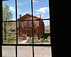
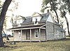
Parker Homestead State Park in Jefferson County reverted to private ownership in 2010.

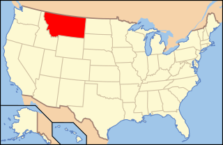
Montana is a state in the Mountain region of the Western United States. It is bordered by Idaho to the west, North Dakota and South Dakota to the east, Wyoming to the south, and the Canadian provinces of Alberta, British Columbia, and Saskatchewan to the north. It is the fourth-largest state by area, the eighth-least populous state, and the third-least densely populated state. Its capital is Helena, while the most populous city is Billings. The western half of the state contains numerous mountain ranges, while the eastern half is characterized by western prairie terrain and badlands, with smaller mountain ranges found throughout the state.
The protected areas of the Northern Territory consists of protected areas managed by the governments of the Northern Territory and Australia and private organisations with a reported total area of 335,527 square kilometres (129,548 sq mi) being 24.8% of the total area of the Northern Territory of Australia.

The Yellowstone River is a tributary of the Missouri River, approximately 692 miles (1,114 km) long, in the Western United States. Considered the principal tributary of upper Missouri, via its own tributaries it drains an area with headwaters across the mountains and high plains of southern Montana and northern Wyoming, and stretching east from the Rocky Mountains in the vicinity of Yellowstone National Park. It flows northeast to its confluence with the Missouri River on the North Dakota side of the border, about 25 miles west of present-day Williston.
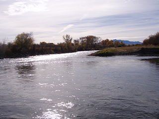
The Jefferson River is a tributary of the Missouri River, approximately 83 miles (134 km) long, in the U.S. state of Montana. The Jefferson River and the Madison River form the official beginning of the Missouri at Missouri Headwaters State Park near Three Forks. It is joined 0.6 miles (1.0 km) downstream (northeast) by the Gallatin.

The Musselshell River is a tributary of the Missouri River, 341.9 miles (550.2 km) long from its origins at the confluence of its North and South Forks near Martinsdale, Montana to its mouth on the Missouri River. It is located east of the Continental divide entirely within Montana in the United States. Counting its pre-confluence tributaries, it measures 425–500 miles (684–805 km) in length.

The Bitterroot River is a northward flowing 84-mile (135 km) river running through the Bitterroot Valley, from the confluence of its West and East forks near Conner in southern Ravalli County to its confluence with the Clark Fork River near Missoula in Missoula County, in western Montana. The Clark Fork River is tributary to the Columbia River and ultimately, the Pacific Ocean. The Bitterroot River is a Blue Ribbon trout fishery with a healthy population of native westslope cutthroat trout and bull trout. It is the third most fly fished river in Montana behind the Madison and Big Horn Rivers.

A buffalo jump, or sometimes bison jump, is a cliff formation which Indigenous peoples of North America historically used to hunt and kill plains bison in mass quantities. The broader term game jump refers to a man-made jump or cliff used for hunting other game, such as reindeer.

Beaverhead Rock, also known as Point of Rocks, is a rock formation overlooking the Beaverhead River in Montana protected as Beaverhead Rock State Park. It is located on Montana State Highway 41, twelve miles (19 km) south of Twin Bridges, Madison County. It was added to the National Register of Historic Places in 1970. The site may be viewed and photographed from a distance, but is not directly accessible.

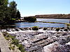
Missouri Headwaters State Park is a public recreation area occupying 535 acres (217 ha) at the site of the official start of the Missouri River. The park offers camping, hiking trails, hunting, and water-related activities. It is located on Trident Road northeast of Three Forks, Montana at an elevation of 4,045 feet (1,233 m). The park includes the Three Forks of the Missouri National Historic Landmark, designated in 1960 because the site is one where the Lewis and Clark Expedition camped in 1805.

Montana is one of the eight Mountain States, located in the north of the region known as the Western United States. It borders North Dakota and South Dakota to the east. Wyoming is to the south, Idaho is to the west and southwest, and the Canadian provinces of British Columbia, Alberta, and Saskatchewan are to the north, making it the only state to border three Canadian provinces.
The following is an alphabetical list of articles related to the U.S. state of Montana.

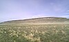
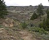
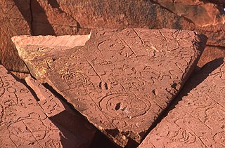
Madison Buffalo Jump State Park is a Montana state park located seven miles south of the Interstate 90 interchange at Logan in Gallatin County, Montana in the United States. The park preserves a canyon cliff used by Native Americans as a buffalo jump, where herds of bison were stampeded over the cliff as an efficient means of slaughter. The main geographic features of the jump site remain largely unchanged since the days of the jumps. Archaeologists have found tons of bison bones buried at the base of the cliffs. They have also uncovered the remains of tipi villages.

First Peoples Buffalo Jump State Park is a Montana state park and National Historic Landmark in Cascade County, Montana in the United States. The park is 1,481 acres (599 ha) and sits at an elevation of 3,773 feet (1,150 m). It is located about 3.5 miles (5.6 km) northwest of the small town of Ulm, which is near the city of Great Falls. First Peoples Buffalo Jump State Park contains the Ulm Pishkun, a historic buffalo jump utilized by the Native American tribes of North America. It has been described as, geographically speaking, either North America's largest buffalo jump or the world's largest. There is some evidence that it was the most utilized buffalo jump in the world. The site was added to the National Register of Historic Places on December 17, 1974, and designated a National Historic Landmark in August 2015. The former name of the park was derived from the Blackfeet word "Pis'kun," meaning "deep kettle of blood," and the nearby town of Ulm.
Rock Creek is a 52-mile (84 km) river in Missoula and Granite County, Montana. Rock Creek is a tributary of the Clark Fork river. The river's headwaters are in Lolo National Forest near Phillipsburg, Montana. The river roughly parallels the Sapphire Mountains and enters the Clark Fork of the Columbia River near Clinton, Montana. Sapphires are found along the river.
Brush Lake State Park is a public recreation area located four miles east of the community of Dagmar, Montana. The park surrounds three sides of the highly alkaline, 280-acre (110 ha), sixty-foot-deep Brush Lake.
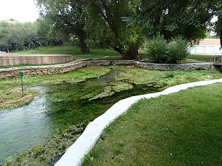
Big Spring Creek is a tributary of the Judith River in Fergus County, Montana near Lewistown, Montana. The creek originates from a first magnitude artesian spring approximately 6 miles (9.7 km) south of Lewistown and flows north, northwest for 30 miles (48 km) to its confluence with the Judith River. The spring is the one of the largest in the world flowing at approximately 50,000 to 64,000 US gallons per minute out of the Madison-Limestone formation in the foothills of the Big Snowy Mountains. The creek flows through and under the town of Lewistown. For three blocks spanning Main Street, the creek runs underneath the town in a man-made channel that was created as the town was built over the creek. The spring provides Lewistown's water supply, which requires no treatment for use by consumers.

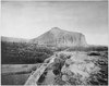
Tower Rock State Park is a state park near the community of Cascade in the U.S. state of Montana in the United States. The centerpiece of the park is Tower Rock, a 424-foot (129 m)-high rock formation which marks the entrance to the Missouri River Canyon in the Adel Mountains Volcanic Field. It was well known to Native Americans, and considered a sacred place by the Piegan Blackfeet. Tower Rock received its current name when Meriwether Lewis of the Lewis and Clark Expedition visited the site in 1805. Railroad and highway development in the late 1800s and 1900s skirted Tower Rock, but the landform itself remained pristine. The 87.2 acres (0.353 km2) encompassing Tower Rock was added to the National Register of Historic Places on March 18, 2002. The 140-acre (0.57 km2) Tower Rock State Park was created around the National Historic Site in 2004.
Painted Rocks State Park is a public recreation area located at the southern end Painted Rocks Reservoir, 24 miles (39 km) south of Darby, Montana. The state park received its name from the green, yellow and orange lichens which cover the grey and black rock walls of the granite and rhyolite cliffs. The park has Bortle scale class 1 skies which makes the state park a great place for astronomy as it is far away from light pollution.

Highway 128 is a designation for four east–west state highways in Southwest Arkansas. One route of 11.99 miles (19.30 km) begins at Highway 7 in Sparkman and runs east to Highway 9 at Holly Springs. A second route of 6.23 miles (10.03 km) begins at Highway 51 at Joan and runs east to Highway 7/Highway 8 at Gravel Junction. A third route begins at Highway 7 near DeGray Lake Resort State Park and runs east and north to US Highway 270 Business (US 270B) in Hot Springs. A fourth route begins at Highway 5 in Fountain Lake and runs east to US 70. All routes are maintained by the Arkansas Department of Transportation (ArDOT).