List of Delaware state parks

Last updated

The U.S. state of Delaware has 17 state parks, as of 2008. Each of the parks is operated and maintained by the Delaware Division of Parks and Recreation, a branch of the Department of Natural Resources and Environmental Control (DNREC), although one state park, First State Heritage Park, is managed by the Division of Parks and Recreation in partnership with other city and state agencies.

Contents

Each of Delaware's three counties has at least one state park, with New Castle having the most. Wilmington State Parks, despite being administratively managed as a single unit, is further broken down into several smaller parks. The state park system includes over 26,000 acres of land [1] and over 160 miles of trails. [2] It is possible to faintly view the Milky Way from 10 of the 17 state parks. [3]

In 2015, Delaware State Parks won the Gold Medal honoring the best state parks system in the country from the National Recreation and Park Association. It was the tenth state to win the award since it was started in 1997, and it beat out finalists Wyoming, Georgia (a seven-time finalist), and Missouri (a three-time finalist). [4]

Overview

Delaware's oldest public lands date back to 1682 when, upon his arrival as proprietor of the colony, William Penn instructed his deputies to set aside land that is now Cape Henlopen State Park and its natural resources to be held in trust for the common good of all the citizens. [2] The earliest attempts at legislating protection of a formalized public parks system were the result of efforts by conservationist William Poole Bancroft, who recognized the beauty of northern Delaware and in the late 19th century became determined to see it preserved for the benefit of future generations. Bancroft also donated many acres of his own land to form public parks as well as created a trust to manage and acquire land for the development of parks after his death.

Several of the state parks in northern Delaware were at one time either partially or wholly owned by estates belonging to members of the Du Pont family that were acquired by the state after the deaths of family members. Several other state parks throughout Delaware were converted from former military installations that were determined to be surplus property.

Three of northern Delaware's state parks (Alapocas Run, Brandywine Creek, and Wilmington) exist to protect pieces of the historic Brandywine River, which was once heavily utilized by local industry. Four of southern Delaware's state parks (Cape Henlopen, Delaware Seashore, Fenwick Island, and Holts Landing) preserve stretches of ocean and bay beaches, which are very popular in summer months.

State parks

NameCountySizeEstab-
lished
ImageRemarks
Alapocas Run New Castle 415 acres (168 ha) [5] 2002 Blueball Dairy barn side Wilmington DE.JPG The park protects a portion of the Brandywine and is connected through a trail network to Wilmington and Brandywine Creek State Parks. It includes the Blue Ball Barn, originally built in 1914 by Alfred I. du Pont, which now houses the Delaware Folk Art Collection.
Auburn Valley New Castle 452 acres (183 ha) [6] [7] 2008 Israel Marshall House Auburn Mills DE.jpg The former estate of the Marshall family includes the 1897 Auburn Heights Mansion and the Marshall Steam Museum's collection of antique steam-powered cars.
Bellevue New Castle 328 acres (133 ha)1976 Bellevue Trail.JPG The former estate of William du Pont, Jr. includes tennis courts, a horse racing barn, and other recreational facilities, as well as Bellevue Hall, a replica of James Madison's Montpelier where du Pont spent his boyhood years.
Brandywine Creek New Castle 933 acres (378 ha)1965 Brandywine Creek State Park farm.jpg Much of this state park was once part of Henry A. du Pont's Winterthur estate and was used as a dairy farm from the 1870s through the 1920s. The rest, protecting land along the Brandywine, was preserved by William Poole Bancroft and his Woodlawn Trustees. The park adjoins First State National Historical Park.
Cape Henlopen Sussex 5,320 acres (2,150 ha)1964 WWII towers at Gordon's Pond.jpg Delaware's largest state park includes the remains of World War II-era Fort Miles and its iconic observation towers which dot the cape's beaches on both the Atlantic Ocean and Delaware Bay. The National Harbor of Refuge and Delaware Breakwater Harbor Historic District and its two lighthouses are visible from the beaches.
Delaware Seashore Sussex 2,825 acres (1,143 ha)1965 Delaware Beaches State Park.jpg The park features beaches on both the Atlantic Ocean and Rehoboth Bay. It also includes the historic Indian River Life Saving Service Station.
Fenwick Island Sussex 379 acres (153 ha) [8] 1966 Fenwickbeach.JPG In 1981 Fenwick Island State Park became a separate park; before that it was the southern part of Delaware Seashore State Park.
First State Heritage Kent 2004 Delaware State Capitol.jpg Designed as an urban "park without boundaries," this park links historic and cultural sites throughout the capital city, Dover.
Fort Delaware New Castle 288 acres (117 ha)1951 Fort delaware aerial photograph 2011.jpg The state park preserves all of Pea Patch Island in the middle of the Delaware River, including the historic Civil War fortress which housed prisoners of war.
Fort DuPont New Castle 322 acres (130 ha)1992 Fort DuPont Parade Grounds.JPG The former military base, named after Rear Admiral Samuel Francis Du Pont, was in use from the Civil War through World War II, and protects a stretch of land along the Delaware River and the Chesapeake and Delaware Canal.
Fox Point New Castle 108 acres (44 ha) [9] 1995 Fox Point Delaware River 01.JPG A former brownfield site along the Delaware River, it was cleaned up and now offers trails and recreational activities.
Holts Landing Sussex 206 acres (83 ha) [10] 1965 Holts Landing Pier.jpg This park used to be a farm and boat ramp operated by the Holts Family.
Killens Pond Kent 1,488 acres (602 ha) [10] 1965 Murderkill River.jpg The core of this park is a 66-acre millpond, but it also includes campgrounds, hiking trails, and a water park.
Lums Pond New Castle 1,790 acres (720 ha)1963 Lums Pond State Park table.jpg Lums Pond was originally used to supply water for the Chesapeake & Delaware Canal when the facility still used canal locks. It is the largest freshwater pond in Delaware and features a new zip-line course.
Trap Pond Sussex 3,653 acres (1,478 ha) [11] 1951 Bald Cypress.JPG The park preserves the northernmost strands of baldcypress trees in the eastern United States.
White Clay Creek New Castle 3,398 acres (1,375 ha) [12] 1968 White Clay Creek State Park - Bryan's Field trailhead.jpg White Clay Creek State Park preserves land around the White Clay Creek National Scenic & Recreational River. It borders Pennsylvania's White Clay Creek Preserve.
Wilmington New Castle 345 acres (140 ha) [13] 1998 [14] Brandywine Park Blossoms.JPG Wilmington State Parks is an urban park unit consisting of several smaller parks protecting land along the Brandywine River in the heart of Wilmington. The park includes Brandywine Park, Brandywine Zoo, H. Fletcher Brown Park, and Rockford Park.

Former state parks

Park NameCountyDate
founded
Date
decommissioned
Description
Brandywine Springs New Castle 19561970The site of a former Revolutionary War encampment and later an amusement park, Brandywine Springs State Park was transferred to New Castle County to operate as a county park.


See also

Related Research Articles

<span class="mw-page-title-main">New Castle County, Delaware</span> County in Delaware, United States

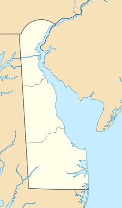
New Castle County is the northernmost of the three counties of the U.S. state of Delaware. As of the 2020 census, the population was 570,719, making it the most populous county in Delaware, with nearly 60% of the state's population of 989,948. The county seat is Wilmington, which is also the state's most populous city.

<span class="mw-page-title-main">Rehoboth Beach, Delaware</span> City in Delaware, United States

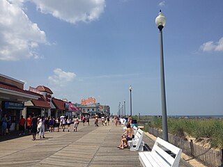
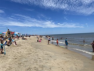
Rehoboth Beach is a city on the Atlantic Ocean along the Delaware Beaches in eastern Sussex County, Delaware. As of the 2010 U.S. census, the population was 1,327, reflecting a decline of 161 (11.2%) from the 1,488 counted in the 2000 census. Along with the neighboring coastal town of Lewes, Rehoboth Beach is one of the principal cities of Delaware's rapidly growing Cape Region. Rehoboth Beach lies within the Salisbury metropolitan area.

<span class="mw-page-title-main">Cape Henlopen State Park</span> State park in Delaware, United States

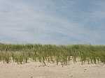
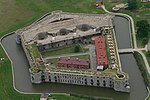
Cape Henlopen State Park is a Delaware state park on 5,193 acres (2,102 ha) on Cape Henlopen in Sussex County, Delaware, in the United States. William Penn made the beaches of Cape Henlopen one of the first public lands established in what has become the United States in 1682 with the declaration that Cape Henlopen would be for "the usage of the citizens of Lewes and Sussex County." Cape Henlopen State Park has a 24-hour and year-round fishing pier as well as campgrounds. The remainder of the park is only open from sunrise to sunset, and includes a bathhouse on the Atlantic Ocean, an area for surf-fishing, a disc golf course, and bicycle and walking paths. The beach at Herring Point is a popular surfing spot. The park is a stop on Delaware's Coastal Heritage Greenway.

<span class="mw-page-title-main">Cape Henlopen</span>

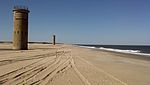
Cape Henlopen is the southern cape of the Delaware Bay along the Atlantic coast of the United States. It lies in the state of Delaware, near the town of Lewes, where the Delaware Bay meets the Atlantic Ocean. Off the coast on the bay side are two lighthouses, called the Harbor of Refuge Light and the Delaware Breakwater East End Light.

<span class="mw-page-title-main">Brandywine Creek (Christina River tributary)</span> Creek in Pennsylvania and Delaware, US

Brandywine Creek is a tributary of the Christina River in southeastern Pennsylvania and northern Delaware in the United States. The Lower Brandywine is 20.4 miles (32.8 km) long and is a designated Pennsylvania Scenic River with several tributary streams. The East Branch and West Branch of the creek originate within 2 miles (3 km) of each other on the slopes of Welsh Mountain in Honey Brook Township, Pennsylvania, about 20 miles (32 km) northwest of their confluence.

<span class="mw-page-title-main">Ridley Creek State Park</span>

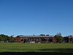
Ridley Creek State Park is a 2,606-acre (1,055 ha) Pennsylvania state park in Edgmont, Middletown, and Upper Providence Townships, Delaware County, Pennsylvania in the United States. The park, about 5 miles (8 km) north of the county seat of Media, offers many recreational activities, such as hiking, biking, fishing, and picnicking. Ridley Creek passes through the park. Highlights include a 5-mile (8 km) paved multi-use trail, a formal garden designed by the Olmsted Brothers, and Colonial Pennsylvania Plantation, which recreates daily life on a pre-Revolutionary farm. The park is adjacent to the John J. Tyler Arboretum. Ridley Creek State Park is just over 16 miles (26 km) from downtown, Philadelphia between Pennsylvania Route 352 and Pennsylvania Route 252 on Gradyville Road.

<span class="mw-page-title-main">White Clay Creek Preserve</span> State park in Chester County, Pennsylvania

White Clay Creek Preserve is a 3,050-acre (1,230 ha) Pennsylvania state park along the valley of White Clay Creek in London Britain Township in Chester County, Pennsylvania in the United States. The park was donated by the DuPont Company in 1984 for the purpose of "preserving the diverse and unique plant and animal species, and the rich cultural heritage of the area". Dupont also donated an additional 528 acres (214 ha) for the adjoining White Clay Creek State Park to the state of Delaware. White Clay Creek Preserve is 3 miles (4.8 km) north of Newark, Delaware on Pennsylvania Route 896.

<span class="mw-page-title-main">Trap Pond State Park</span> State park in Delaware, United States

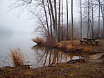
Trap Pond State Park is a 3,653 acre (8.5 km²) Delaware state park located near Laurel, Delaware, USA. It is one of the largest surviving fragments of what was once an extensive wetland in what is now southwestern Sussex County. The state park features an extensive patch of bald cypress trees.

<span class="mw-page-title-main">Brandywine Creek State Park</span> State park in Delaware, United States

Brandywine Creek State Park is a state park, located 3 miles (4.8 km) north of Wilmington, Delaware along the Brandywine Creek. Open year-round, it is 933 acres (378 ha) in area and much of the park was part of a Du Pont family estate and dairy farm before becoming a state park in 1965. It contains the first two nature preserves in Delaware. These nature preserves are Tulip Tree Woods and Freshwater Marsh. Flint Woods is a satellite area of the park and has become the park's third nature preserve. Flint Woods is home to species of rare song birds and an old-growth forest. The park's forests are part of the Northeastern coastal forests ecoregion.

<span class="mw-page-title-main">Fox Point State Park</span> State park in Delaware, United States

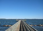
Fox Point State Park is a Delaware state park on 108 acres (44 ha) along the Delaware River in New Castle County, Delaware in the United States. The park, which opened in 1995, has been built atop a former hazardous waste site that has been rehabilitated under an adaptive reuse program that was spearheaded by S. Marston Fox and the Fox Point Civic Association. Fox Point State Park is open for year-round use from 8:00 am until sunset. The park offers recreational opportunities on biking and pedestrian trails with picnic facilities, a playground and volleyball and horseshoes facilities. Fox Point State Park is just off Interstate 495 and is the northern terminus of Delaware's Coastal Heritage Greenway.

<span class="mw-page-title-main">Lums Pond State Park</span> State park in Delaware, United States

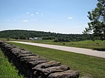
Lums Pond State Park is a 1,790-acre (720 ha) Delaware state park near Bear, New Castle County, Delaware in the United States. The park surrounds Lums Pond, an impoundment built by the Chesapeake and Delaware Canal on St. Georges Creek. The C&D built the pond as a source of water to fill the locks of the canal that connected the Chesapeake Bay with the Delaware River during the early 19th century. Lums Pond State Park is open for a wide variety of year-round recreation.

<span class="mw-page-title-main">Wilmington State Parks</span> State park in Delaware, United States

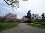
Wilmington State Parks is a state park located in Wilmington, Delaware. Open year round, the park is approximately 345 acres (140 ha) of land mostly situated along the Brandywine Creek. The state park is made up of a group of smaller parks that are administratively managed as a single unit.

<span class="mw-page-title-main">Bellevue State Park (Delaware)</span> State park in Delaware, United States

Bellevue State Park is a 328-acre (133 ha) Delaware state park in the suburbs of Wilmington in New Castle County, Delaware in the United States. The park is named for Bellevue Hall, the former mansion of William du Pont Jr. Many of the facilities at the park were built by du Pont. Bellevue State Park overlooks the Delaware River and is open for year-round recreation, daily, from 8 a.m. until sunset. The Mount Pleasant Methodist Episcopal Church and Parsonage is located in Bellevue State Park; it was added to the National Register of Historic Places in 1998. Cauffiel House is a historic home in the park near Stoney Creek.

<span class="mw-page-title-main">Beaver Valley, Delaware and Pennsylvania</span> Unincorporated community in Delaware and Pennsylvania, United States

Beaver Valley straddles the Pennsylvania and Delaware border in Delaware County, PA and New Castle County, DE. An unincorporated place name, it is traversed by several streams which drain to Beaver Run which itself empties into the Brandywine River. It is approximately bounded by US Route 202 to the east, The Brandywine River to the west, Thompsons Bridge Road to the south, and Smithbridge Road to the north, with Beaver Valley Road encircling a large portion of the valley.

Edenridge is an unincorporated community in New Castle County, Delaware, United States in the Brandywine Hundred, north of Wilmington.

<span class="mw-page-title-main">Woodbrook, Delaware</span> Unincorporated community in Delaware, United States

Woodbrook is a suburban community in New Castle County, Delaware.

<span class="mw-page-title-main">Alapocas Run State Park</span> State park in Delaware, United States

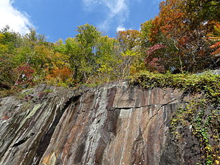
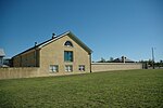
Alapocas Run State Park is a state park, located in Wilmington, Delaware, United States, along the Brandywine Creek and its Alapocas Run tributary. Open year-round, it is 415 acres (168 ha) in area. Much of the state park was created from land originally preserved by William Poole Bancroft in the early 1900s to be used as open space parkland by the city of Wilmington as it expanded. The park also includes the Blue Ball Barn, a dairy barn built by Alfred I. du Pont as part of his Nemours estate in 1914. In addition to walking trails, athletic fields, and playgrounds for children, one of the park's primary features is a rock climbing wall. The rock climbing wall is part of an old quarry across from historic Bancroft Mills on the Brandywine, and the quarry is also used for school educational programs centered on earth sciences.

<span class="mw-page-title-main">Alapocas Run</span> Stream in Delaware, USA

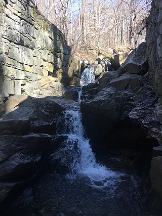
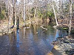
Alapocas Run is a 1.05 mi (1.69 km) long tributary to Brandywine Creek in New Castle County, Delaware. This run drains a large portion of Alapocas Run State Park in the Wilmington, Delaware area.

References

  1. "Delaware State Parks Programming - Spring Guide" (PDF). Delaware State Parks. Archived from the original (PDF) on 29 March 2015. Retrieved 21 April 2015.
  2. 1 2 "Cape Henlopen State Park to Celebrate its 50th Anniversary". Delaware State Parks. Retrieved 21 April 2015.
  3. R, Mike (2021-08-13). "State Parks Light Pollution Map And Statistics". CosmosPNW. Retrieved 2022-01-16.
  4. Shockley, Beth. "Delaware State Parks honored as top state parks system in nation by winning NRPA gold medal". Delaware Department of Natural Resources and Environmental Control. Retrieved 25 November 2015.
  5. Coxe, Robert. "Historical Analysis and Map of Vegetation Communities, Land Covers, and Habitats of Alapocas Run State Park" (PDF). University of Delaware. Archived from the original (PDF) on 5 October 2015. Retrieved 5 October 2015.
  6. "Delaware Business Now". State parks system adds 86 acres to Auburn Valley. Retrieved 6 May 2019.
  7. Weigel, Shawn (8 June 2015). "Auburn Heights: Delaware's 'best kept secret'". Hockessin Community News. Retrieved 8 October 2015.
  8. Coxe, Robert. "Historical Analysis and Map of Vegetation Communities, Land Covers, and Habitats of Fenwick Island State Park" (PDF). University of Delaware. Retrieved 1 November 2015.
  9. Coxe, Robert. "Historical Analysis and Map of Vegetation Communities, Land Covers, and Habitats of Fox Point State Park" (PDF). University of Delaware. Retrieved 5 November 2015.
  10. 1 2 "Delaware State Parks Summer Guide 2015" (PDF). Delaware Division of Natural Resources and Environmental Control. Archived from the original (PDF) on 25 November 2015. Retrieved 9 October 2015.
  11. Coxe, Robert. "Historical Analysis and Map of Vegetation Communities, Land Covers, and Habitats of Trap Pond State Park" (PDF). University of Delaware. Retrieved 1 November 2015.
  12. Coxe, Robert. "Historical Analysis and Map of Vegetation Communities, Land Covers, and Habitats of White Clay Creek State Park" (PDF). University of Delaware. Retrieved 5 October 2015.
  13. Coxe, Robert. "Historical Analysis and Map of Vegetation Communities, Land Covers, and Habitats of Wilmington State Park New Castle County, Delaware" (PDF). University of Delaware. Retrieved 5 October 2015.
  14. "Delaware State Parks: Highlights of History". Archived from the original on November 5, 2003. Retrieved 21 September 2015.