Odessa, Delaware

Last updated
Odessa, Delaware
Cantwells Tavern Odessa DE.JPG
Cantwells Tavern
Etymology: Ukrainian port city of Odessa
New Castle County Delaware Incorporated and Unincorporated areas Odessa Highlighted 1054050.svg
Location of Odessa in New Castle County, Delaware
USA Delaware location map.svg
Red pog.svg
Odessa
Location of Odessa in Delaware
Usa edcp location map.svg
Red pog.svg
Odessa
Odessa (the United States)
Coordinates: 39°27′26″N75°39′41″W / 39.45722°N 75.66139°W / 39.45722; -75.66139 Coordinates: 39°27′26″N75°39′41″W / 39.45722°N 75.66139°W / 39.45722; -75.66139
CountryFlag of the United States.svg  United States
State Flag of Delaware.svg  Delaware
County New Castle
Government
  MayorHarvey C. Smith, Jr.
Area
[1]
  Total0.52 sq mi (1.35 km2)
  Land0.51 sq mi (1.31 km2)
  Water0.01 sq mi (0.04 km2)
Elevation
52 ft (16 m)
Population
 (2020)
  Total366
  Density721.89/sq mi (278.59/km2)
Time zone UTC−5 (Eastern (EST))
  Summer (DST) UTC−4 (EDT)
ZIP code
19730
Area code 302
FIPS code 10-54050
GNIS feature ID214404 [2]
Website www.odessa.delaware.gov

Odessa is a town in New Castle County, Delaware, United States. The population was 364 at the 2010 census. [3] Founded as Cantwell's Bridge in the 18th century, the name was changed in the 19th century, after the Ukrainian port city of the same name. Today a significant part of the town is a historic district list on the National Register of Historic Places.

Contents

History

Odessa was originally known as Cantwell's Bridge. In 1721, a son of Captain Edmund Cantwell opened a toll bridge over the Appoquinimink Creek at this location. Cantwell's Bridge became an important port that shipped wheat, corn, tobacco, and produce down the creek to the Delaware Bay, where it traveled to distant ports. The town was also home to tanneries that produced leather goods. Cantwell's Bridge would continue to prosper as an agricultural port into the 19th century. In 1855, the grain trade collapsed after the Delaware Railroad was built to the west through Middletown. The railroad was originally proposed to be built through Cantwell's Bridge but the merchants and vessel owners in the town opposed. Following this, the town was renamed to Odessa after the port city of Odessa in Ukraine in an effort to keep the town alive as a major port. The town saw a slight boom during the American Civil War. [4]

Geography

Odessa is located at 39°27′26″N75°39′41″W / 39.45722°N 75.66139°W / 39.45722; -75.66139 (39.4573340°N, 75.6613184°W), [5] along the Appoquinimink River. [6]

According to the United States Census Bureau, the town has a total area of 0.4 square miles (1.0 km2), of which 0.4 square miles (1.0 km2) is land and 2.22% is water.

Infrastructure

Transportation

DE Route 1 southbound in Odessa 2022-07-18 10 23 50 View south along Delaware State Route 1 (Korean War Veterans Memorial Parkway) at Exit 136 (Delaware State Route 299, Odessa, Middletown) in Odessa, New Castle County, Delaware.jpg
DE Route 1 southbound in Odessa

The Delaware Route 1 toll road is the most significant highway passing through Odessa. Its route follows the western edge of town, with an interchange with DE 299 that serves Odessa and neighboring Middletown. [7] U.S. Route 13 passes through the heart of Odessa along Dupont Parkway, which follows 5th Street northbound and 6th Street southbound. Delaware Route 299 is the main east-west route in Odessa, passing through the town along Main Street. DART First State provides bus service to Odessa at a park and ride lot west of the town near the interchange between DE 1 and DE 299. The park and ride lot serves the Route 43 and Route 63 buses to Middletown, the Route 301 bus to Wilmington and Dover, and the seasonal Route 305 "Beach Connection bus to Lewes and Rehoboth Beach. [8]

Utilities

Delmarva Power, a subsidiary of Exelon, provides electricity to Odessa. [9] Chesapeake Utilities provides natural gas to the town. [10] Trash and recycling collection is provided by the town. [11]

Education

Odessa is within the Appoquinimink School District. [12] Odessa High School is nearby.MOT Charter School is an area charter school. [13]

Demographics

Historical population
CensusPop.Note
1850 501
1860 68636.9%
1870 6951.3%
1880 675−2.9%
1890 640−5.2%
1900 575−10.2%
1910 5851.7%
1920 435−25.6%
1930 385−11.5%
1940 3911.6%
1950 46719.4%
1960 52612.6%
1970 5474.0%
1980 384−29.8%
1990 303−21.1%
2000 286−5.6%
2010 36427.3%
2020 3660.5%
U.S. Decennial Census [14]

At the 2000 census there were 286 people, 119 households, and 84 families living in the town. The population density was 652.6 inhabitants per square mile (252.0/km2). There were 127 housing units at an average density of 289.8 per square mile (111.9/km2). The racial makeup of the town was 94.06% White, 5.24% African American, 0.35% Pacific Islander, and 0.35% from two or more races. Hispanic or Latino of any race were 1.05%. [15]

Of the 119 households 27.7% had children under the age of 18 living with them, 54.6% were married couples living together, 12.6% had a female householder with no husband present, and 29.4% were non-families. 22.7% of households were one person and 10.9% were one person aged 65 or older. The average household size was 2.40 and the average family size was 2.80.

The age distribution was 19.9% under the age of 18, 5.9% from 18 to 24, 26.9% from 25 to 44, 29.4% from 45 to 64, and 17.8% 65 or older. The median age was 42 years. For every 100 females, there were 95.9 males. For every 100 females age 18 and over, there were 90.8 males.

The median household income was $53,269 and the median family income was $55,938. Males had a median income of $31,875 versus $33,750 for females. The per capita income for the town was $27,662. None of the families and 3.2% of the population were living below the poverty line.

See also

Related Research Articles

<span class="mw-page-title-main">Cheswold, Delaware</span> Town in Delaware, United States

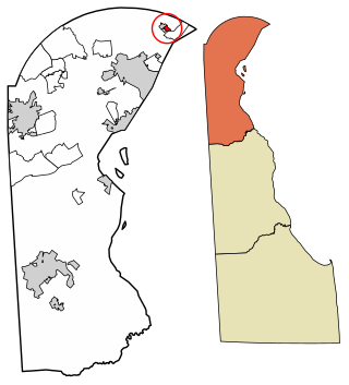
Cheswold is a town in Kent County in the U.S. state of Delaware. It is part of the Dover, Delaware Metropolitan Statistical Area. The population was 1,380 at the 2010 census.

<span class="mw-page-title-main">Clayton, Delaware</span> Town in Delaware, United States

Clayton is a town in Kent and New Castle counties in the U.S. state of Delaware. Located almost entirely in Kent County, it is part of the Dover, Delaware Metropolitan Statistical Area. The population was 2,918 at the 2010 census.

<span class="mw-page-title-main">Felton, Delaware</span> Town in Delaware, United States

Felton is a town in Kent County, Delaware, United States. It is part of the Dover, Delaware Metropolitan Statistical Area. The population was 1,298 at the 2010 census.

<span class="mw-page-title-main">Frederica, Delaware</span> Town in Delaware, United States

Frederica is a town in Kent County, Delaware, United States. It is part of the Dover, Delaware Metropolitan Statistical Area. The population was 774 at the 2010 census. ILC Dover, the company which manufactured the spacesuits for the Apollo and Skylab astronauts of the 1960s and 1970s, along with fabricating the suit component of the Space Shuttle's Extravehicular Mobility Unit (EMU), is located nearby.

<span class="mw-page-title-main">Hartly, Delaware</span> Town in Delaware, United States

Hartly is a town in Kent County, Delaware, United States. It is part of the Dover, Delaware Metropolitan Statistical Area. The population was 74 at the 2010 census, making it the least populous municipality in Delaware.

<span class="mw-page-title-main">Houston, Delaware</span> Town in Delaware, United States

Houston is a town in Kent County, Delaware, United States. It is part of the Dover, Delaware Metropolitan Statistical Area. The population was 374 at the 2010 census. It was named for John W. Houston.

<span class="mw-page-title-main">Leipsic, Delaware</span> Town in Delaware, United States

Leipsic is a town in Kent County, Delaware, United States. It is part of the Dover, Delaware Metropolitan Statistical Area. The population was 183 at the 2010 census.

<span class="mw-page-title-main">Little Creek, Delaware</span> Town in Delaware, United States

Little Creek is a town in Kent County, Delaware, United States. It is part of the Dover, Delaware Metropolitan Statistical Area. The population was 224 at the 2010 census.

<span class="mw-page-title-main">Magnolia, Delaware</span> Town in Delaware, United States

Magnolia is a town in Kent County, Delaware, United States. It is part of the Dover, Delaware Metropolitan Statistical Area. Recent estimates put the population at around 235, however, the population was 225 at the 2010 census.

<span class="mw-page-title-main">Viola, Delaware</span> Town in Delaware, United States

Viola is a town in Kent County, Delaware, United States. It is part of the Dover, Delaware Metropolitan Statistical Area. The population was 157 at the 2010 census.

<span class="mw-page-title-main">Woodside, Delaware</span> Town in Delaware, United States

Woodside is a town in Kent County, Delaware, United States. It is part of the Dover, Delaware Metropolitan Statistical Area. The population was 181 at the 2010 census.

<span class="mw-page-title-main">Wyoming, Delaware</span> Town in Delaware, United States

Wyoming is a town in Kent County, Delaware, United States. It was named after the Wyoming Valley in Pennsylvania. It is part of the Dover, Delaware, Metropolitan Statistical Area. The population was 1,313 at the 2010 census.

<span class="mw-page-title-main">Ardentown, Delaware</span> Village in Delaware, United States

Ardentown is a village in New Castle County, Delaware, United States. According to the 2010 Census, the population of the village is 264.

<span class="mw-page-title-main">Bellefonte, Delaware</span> Town in Delaware, United States

Bellefonte is a town in New Castle County, Delaware, United States. According to the 2010 Census, the population of the town is 1,193.

<span class="mw-page-title-main">Delaware City, Delaware</span> City in Delaware, United States

Delaware City is a city in New Castle County, Delaware, United States. The population was 1,695 at the 2010 census. It is a small port town on the eastern terminus of the Chesapeake and Delaware Canal and is the location of the Forts Ferry Crossing to Fort Delaware on Pea Patch Island.

<span class="mw-page-title-main">Middletown, Delaware</span> Town in Delaware, United States

Middletown is a town in New Castle County, Delaware, United States. According to the 2021 Census, the population of the town is 24,164.

<span class="mw-page-title-main">Townsend, Delaware</span> Town in Delaware, United States

Townsend is a town in New Castle County, Delaware, United States. The population was 2,049 at the 2010 census, an increase of 492.2% from 2000. The center of population of Delaware is located in Townsend.

<span class="mw-page-title-main">Blades, Delaware</span> Town in Delaware, United States

Blades is a town in Sussex County, Delaware, United States. As of the 2010 census, the town population was 1,241, a 29.8% increase over the previous decade. It is part of the Salisbury, Maryland-Delaware Metropolitan Statistical Area.

<span class="mw-page-title-main">Bridgeville, Delaware</span> Town in Delaware, United States

Bridgeville is a town in Sussex County, Delaware, United States. According to the 2010 census, the population is 2,048, an increase of 42.6% from the previous decade. It is part of the Salisbury, Maryland-Delaware Metropolitan Statistical Area.

<span class="mw-page-title-main">Fenwick Island, Delaware</span> Town in Delaware, United States

Fenwick Island is a coastal resort town in Sussex County, Delaware, United States. According to 2020 census figures, the population of the town is 355, a 2.6% decrease over the last decade. It is part of the Salisbury, Maryland-Delaware Metropolitan Statistical Area. The town is located on Fenwick Island, a barrier spit.

References

  1. "2020 U.S. Gazetteer Files". United States Census Bureau. Retrieved October 31, 2021.
  2. "Odessa". Geographic Names Information System . United States Geological Survey, United States Department of the Interior.
  3. "Your title here". www.census.gov. Retrieved 2020-01-08.
  4. Federal Writers' Project (1938). The ocean highway: New Brunswick, New Jersey to Jacksonville, Florida. American Guide Series. New York: Modern Age Books. Retrieved 2009-04-10.
  5. "US Gazetteer files: 2010, 2000, and 1990". United States Census Bureau. 2011-02-12. Retrieved 2011-04-23.
  6. DeLorme (2004). Maryland Delaware Atlas & Gazetteer. p.78. Yarmouth, Maine: DeLorme. ISBN   0-89933-279-X.
  7. Delaware Department of Transportation (2008). Delaware Official Transportation Map (PDF) (Map). Dover: Delaware Department of Transportation.
  8. "Routes and Schedules". DART First State. Retrieved August 16, 2013.
  9. "Service Territory". Delmarva Power. Archived from the original on May 25, 2014. Retrieved August 15, 2017.
  10. "Delmarva Service Territory". Chesapeake Utilities. Retrieved August 14, 2017.
  11. "Yard Waste Disposal". Town of Odessa, Delaware. Retrieved June 30, 2018.
  12. "2020 CENSUS - SCHOOL DISTRICT REFERENCE MAP: New Castle County, DE" (PDF). U.S. Census Bureau . Retrieved 2021-06-18.
  13. "PHOTOS: Back to school in M.O.T. area". Middletown Transcript . 2016-09-01. Retrieved 2021-07-05. Most schools in the Middletown-Odessa-Townsend area[...] while M.O.T. Charter School students [...]
  14. "Census of Population and Housing". Census.gov. Retrieved June 4, 2016.
  15. "U.S. Census website". United States Census Bureau . Retrieved 2008-01-31.