Elsmere, Delaware

Last updated

Elsmere, Delaware
Town of Elsmere
DE 2 WB at Poplar Avenue Elsmere.jpg
Kirkwood Highway in Elsmere
New Castle County Delaware Incorporated and Unincorporated areas Elsmere Highlighted 1024540.svg
Location of Elsmere in New Castle County, Delaware.
USA Delaware location map.svg
Red pog.svg
Elsmere
Location within the state of Delaware
Usa edcp location map.svg
Red pog.svg
Elsmere
Elsmere (the United States)
Coordinates: 39°44′21″N75°35′53″W / 39.73917°N 75.59806°W / 39.73917; -75.59806
CountryFlag of the United States.svg  United States
State Flag of Delaware.svg  Delaware
County New Castle
Incorporated1909
Government
  Type Mayor-council
  MayorEric Scott Thompson
Area
[1]
  Total0.99 sq mi (2.56 km2)
  Land0.99 sq mi (2.56 km2)
  Water0.00 sq mi (0.00 km2)
Elevation
98 ft (30 m)
Population
 (2020)
  Total6,229
  Density6,311.04/sq mi (2,437.75/km2)
Time zone UTC−5 (Eastern (EST))
  Summer (DST) UTC−4 (EDT)
ZIP codes
19805, 19804
Area code 302
FIPS code 10-24540
GNIS feature ID213941 [2]
Website https://www.townofelsmere.com/

Elsmere is a town in New Castle County, Delaware, United States, bordering the city of Wilmington along Wilmington's western border. According to the 2010 Census, the population of the town is 6,131. [3]

Contents

History

Elsmere dates back to 1886 when real estate developer Joshua Heald bought farmland and converted it into houses, building the first suburb in northern Delaware. The community was built at an intersection of railroad lines and allowed working-class families easy access to Wilmington. Trolley lines were later built leading to Elsmere. In 1909, Elsmere was incorporated as a town. [4]

During the 1910s, the Delaware State Fair Association purchased land and built a new fairgrounds within Elsmere's town limit. The grounds, including a racecourse for horses, cars and motorcycles, were located south of New Road and Wilmington Avenue and west of the previously established streets. This land became the site of the Delaware State Fair from 1917 to 1928, and provided a large parking area and ready access from the nearby trolley line. Agricultural exhibits provided the backbone of the fair, but in addition to the races, the summer attraction also included horse and dog shows, vaudeville acts, music, and fireworks. After 1928, the State Fair had moved to Harrington, but the grandstand and the races remained until 1943, when the property was converted to land for residential housing. [5]

In 1950, a 336-bed Veteran's Administration hospital opened on the western edge of town. This was the ninth VA hospital built after the conclusion of World War II. [6]

Geography

Elsmere is located at 39°44′21″N75°35′53″W / 39.73917°N 75.59806°W / 39.73917; -75.59806 (39.7392796, –75.5979812). [7]

According to the United States Census Bureau, the town has a total area of 1.0 square mile (2.6 km2), all land. Elsmere is 1.5 miles away from Wilmington

Climate

The climate in this area is characterized by hot, humid summers and generally mild to cool winters. According to the Köppen Climate Classification system, Elsmere has a humid subtropical climate, abbreviated "Cfa" on climate maps.

Climate data for Elsmere, Delaware
MonthJanFebMarAprMayJunJulAugSepOctNovDecYear
Record high °F (°C)74
(23)
74
(23)
87
(31)
94
(34)
94
(34)
98
(37)
101
(38)
100
(38)
97
(36)
89
(32)
84
(29)
73
(23)
101
(38)
Mean daily maximum °F (°C)39
(4)
42
(6)
51
(11)
62
(17)
72
(22)
81
(27)
85
(29)
83
(28)
76
(24)
64
(18)
54
(12)
43
(6)
63
(17)
Mean daily minimum °F (°C)25
(−4)
27
(−3)
34
(1)
43
(6)
53
(12)
63
(17)
68
(20)
66
(19)
59
(15)
47
(8)
39
(4)
29
(−2)
46
(8)
Record low °F (°C)−9
(−23)
−5
(−21)
5
(−15)
19
(−7)
29
(−2)
41
(5)
51
(11)
43
(6)
35
(2)
24
(−4)
14
(−10)
−1
(−18)
−9
(−23)
Average precipitation inches (mm)3.71
(94)
3.10
(79)
4.52
(115)
4.21
(107)
4.38
(111)
4.19
(106)
5.36
(136)
3.67
(93)
4.90
(124)
3.81
(97)
3.48
(88)
4.10
(104)
49.43
(1,254)
Source: The Weather Channel [8]

Demographics

Historical population
CensusPop.Note
1910 374
1920 62065.8%
1930 1,323113.4%
1940 1,63023.2%
1950 5,314226.0%
1960 7,31937.7%
1970 8,41515.0%
1980 6,493−22.8%
1990 5,935−8.6%
2000 5,800−2.3%
2010 6,1315.7%
2020 6,2291.6%
U.S. Decennial Census [9]

As of the census [10] of 2000, there were 5,800 people, 2,299 households, and 1,487 families residing in the town. The population density was 5,891.0 inhabitants per square mile (2,274.5/km2). There were 2,395 housing units at an average density of 2,432.6 per square mile (939.2/km2). The racial makeup of the town was 82.41% White, 9.45% African American, 0.22% Native American, 0.97% Asian, 5.10% from other races, and 1.84% from two or more races. Hispanic or Latino of any race were 12.09% of the population.

There were 2,299 households, out of which 31.2% had children under the age of 18 living with them, 42.5% were married couples living together, 16.4% had a female householder with no husband present, and 35.3% were non-families. 28.5% of all households were made up of individuals, and 11.5% had someone living alone who was 65 years of age or older. The average household size was 2.52 and the average family size was 3.09.

In the town, the population was spread out, with 25.1% under the age of 18, 9.5% from 18 to 24, 31.1% from 25 to 44, 19.7% from 45 to 64, and 14.7% who were 65 years of age or older. The median age was 36 years. For every 100 females, there were 96.0 males. For every 100 females age 18 and over, there were 91.8 males.

The median income for a household in the town was $39,415, and the median income for a family was $46,357. Males had a median income of $35,427 versus $28,089 for females. The per capita income for the town was $18,643. About 6.7% of families and 8.9% of the population were below the poverty line, including 11.8% of those under age 18 and 8.6% of those age 65 or over.

Government

Town hall and police station in Elsmere Elsmere DE town hall and police station.jpg
Town hall and police station in Elsmere

Elsmere has a mayor-council system of government consisting of a Mayor and a six-member Town Council, with Town Council members elected by district. As of 2022, the Mayor is Eric Scott Thompson while the Town Council consists of Marianne Skipski (1st District), Sally Jensen (2nd District), Mary Steppi (3rd District), Charles McKewen (4th District), Joann Personti (5th District), and Dawn DiBiaso (6th District). [11]

Police services in the town is provided by the Elsmere Police Department, which consists of a Chief of Police, Administrative Assistant, Lieutenant, two Patrol Sergeants, Sr. CPL, CPL, two PFCs, and three Patrolmen. [12] Fire protection in the town is provided by the Elsmere Fire Company No. 1, which was founded in 1921. [13]

Mayors

Parks and recreation

Elsmere is home to multiple small neighborhood parks. Parks in Elsmere include Junction Street Park, Fairgrounds Park, Joseph R. Walling Park, Maple Avenue Park, Brian Martin Park, Vilone Park, and Veterans Park. The town is also home to Elsmere Bark Park, which is a dog park. [14]

Education

The town of Elsmere is served by the Red Clay Consolidated School District for public education. [15] The school district maintains one school in the town: Austin D. Baltz Elementary School (Grades K through 5). [16] Public school students in Elsmere in grades 6 through 8 attend Alexis I. duPont Middle School in Greenville while students in grades 9 through 12 attend Thomas McKean High School northwest of Elsmere near Hockessin. [17] [18]

The Diocese of Wilmington operates All Saints Catholic School (PreK through 8). Formally known as Corpus Christi School, All Saints is a merge of Corpus Christi, St. Matthew School, St. Catherine of Siena, and Our Lady of Fatima.

Infrastructure

Transportation

DE 2 eastbound in Elsmere 2022-07-24 14 38 06 View east along Delaware State Route 2 (Robert Kirkwood Highway) at New Road and Linden Avenue in Elsmere, New Castle County, Delaware.jpg
DE 2 eastbound in Elsmere

The main east–west road in Elsmere is Delaware Route 2 (Kirkwood Highway), which heads east to Wilmington and west to Newark. Delaware Route 100 (Dupont Road) runs north–south through the eastern part of Elsmere. Delaware Route 141 passes to the west of Elsmere, with access to the town via an interchange with DE 2 in Prices Corner. DE 141 heads south through Newport and provides access to Interstate 95, Interstate 295, and Interstate 495. [19] DART First State provides bus service to Elsmere along Route 6, which follows Kirkwood Highway and heads east to Wilmington station, which is served by Amtrak and SEPTA Regional Rail's Wilmington/Newark Line, and west to the Newark Transit Hub. [20] Freight trains pass through Elsmere along CSX Transportation's Philadelphia Subdivision line and East Penn Railroad's Wilmington & Northern line, both of which interchange at Elsmere Junction. CSX Transportation operates the Wilsmere Yard to the south of Elsmere near the former Wilmington Assembly plant used by General Motors. [19] [21]

Utilities

Delmarva Power, a subsidiary of Exelon, provides electricity and natural gas to Elsmere. [22] [23] Artesian Water Company, a subsidiary of Artesian Resources, provides water to Elsmere. [24] Sewer service in Elsmere is provided by New Castle County. Trash and recycling collection in Elsmere is provided under contract by Waste Management. [25]

Health care

Elsmere is home to the Wilmington VA Medical Center, a veterans hospital operated by the Veterans Health Administration. [26] Hospitals near Elsmere include Wilmington Hospital and St. Francis Hospital in Wilmington and Christiana Hospital in Christiana.

Notable people

Related Research Articles

<span class="mw-page-title-main">Dover, Delaware</span> Capital city of Delaware, United States

Dover is the capital and second-most populous city of the U.S. state of Delaware. It is also the county seat of Kent County and the principal city of the Dover metropolitan statistical area, which encompasses all of Kent County and is part of the Philadelphia–Wilmington–Camden, PA–NJ–DE–MD, combined statistical area. It is located on the St. Jones River in the Delaware River coastal plain. It was named by William Penn for Dover in Kent, England. As of 2020, its population was 39,403.

<span class="mw-page-title-main">Bowers, Delaware</span> Town in Delaware, United States

Bowers is a town in Kent County, Delaware, United States. It is part of the Dover, Delaware Metropolitan Statistical Area. According to the 2020 census, its population was 278.

<span class="mw-page-title-main">Camden, Delaware</span> Town in Delaware, United States

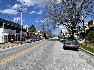
Camden is a town in Kent County, Delaware, United States. It is part of the Dover, Delaware Metropolitan Statistical Area. The population was 3,715 in 2020.

<span class="mw-page-title-main">Cheswold, Delaware</span> Town in Delaware, United States

Cheswold is a town in Kent County in the U.S. state of Delaware. It is part of the Dover, Delaware Metropolitan Statistical Area. The population was 1,923 in 2020.

<span class="mw-page-title-main">Felton, Delaware</span> Town in Delaware, United States

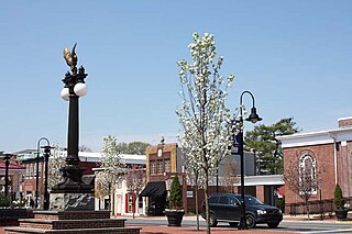
Felton is a town in Kent County, Delaware, United States. It is part of the Dover metropolitan statistical area. The population was 1,568 in 2020.

<span class="mw-page-title-main">Frederica, Delaware</span> Town in Delaware, United States

Frederica is a town in Kent County, Delaware, United States. It is part of the Dover, Delaware Metropolitan Statistical Area. The population was 1,073 in 2020. ILC Dover, the company which manufactured the spacesuits for the Apollo and Skylab astronauts of the 1960s and 1970s, along with fabricating the suit component of the Space Shuttle's Extravehicular Mobility Unit (EMU), is located nearby.

<span class="mw-page-title-main">Kenton, Delaware</span> Town in Delaware, United States

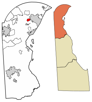
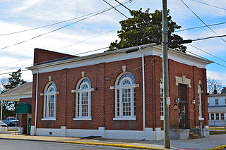
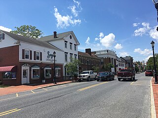
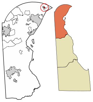
Kenton is a town in Kent County, Delaware, United States. It is part of the Dover metropolitan statistical area. The population was 215 in 2020.

<span class="mw-page-title-main">Smyrna, Delaware</span> Town in Delaware, United States

Smyrna is a town in Kent and New Castle counties in the U.S. state of Delaware. It is part of the Dover metropolitan statistical area. According to the U.S. Census Bureau, as of 2020, the population of the town is 12,883.

<span class="mw-page-title-main">Wyoming, Delaware</span> Town in Delaware, United States

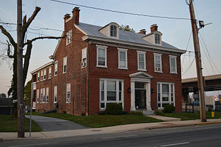
Wyoming is a town in Kent County, Delaware, United States. It was named after the Wyoming Valley in Pennsylvania. It is part of the Dover, Delaware, Metropolitan Statistical Area. The population was 1,680 in 2020.

<span class="mw-page-title-main">Ardencroft, Delaware</span> Village in Delaware, United States

Ardencroft is a village in New Castle County, Delaware, United States. According to the 2010 census, the population of the village is 231.

<span class="mw-page-title-main">Ardentown, Delaware</span> Village in Delaware, United States

Ardentown is a village in New Castle County, Delaware, United States. According to the 2010 Census, the population of the village is 264.

<span class="mw-page-title-main">Bellefonte, Delaware</span> Town in Delaware, United States

Bellefonte is a town in New Castle County, Delaware, United States. According to the 2010 Census, the population of the town is 1,193.

<span class="mw-page-title-main">Middletown, Delaware</span> Town in Delaware, United States

Middletown is a town in New Castle County, Delaware, United States. According to the 2021 Census, the population of the town is 24,164.

<span class="mw-page-title-main">New Castle, Delaware</span> City in Delaware, United States

New Castle is a city in New Castle County, Delaware, United States. The city is located six miles (10 km) south of Wilmington and is situated on the Delaware River. As of 2020, the city's population was 5,551. New Castle constitutes part of the Delaware Valley or Philadelphia metropolitan area.

<span class="mw-page-title-main">Newark, Delaware</span> City in New Castle County, Delaware, U.S.

Newark is a small city in New Castle County, Delaware, United States. It is located 12 miles (19 km) west-southwest of Wilmington. According to the 2010 Census, the population of the city is 31,454. Newark is home to the University of Delaware. The city constitutes part of the Delaware Valley.

<span class="mw-page-title-main">Newport, Delaware</span> Town in Delaware, United States

Newport is a town in New Castle County, Delaware, United States. It is on the Christina River. It is best known for being the home of colonial inventor Oliver Evans. The population was 1,055 at the 2010 census. Four limited access highways, I-95, I-295, I-495, and Delaware Route 141 intersect within one mile (1.6 km) of the town.

<span class="mw-page-title-main">Odessa, Delaware</span> Town in Delaware, United States

Odessa is a town in New Castle County, Delaware, United States. The population was 364 at the 2010 census. Founded as Cantwell's Bridge in the 18th century, the name was changed in the 19th century, after the Ukrainian port city of the same name. Today a significant part of the town is a historic district list on the National Register of Historic Places.

<span class="mw-page-title-main">Dewey Beach, Delaware</span> Town in Delaware, United States

Dewey Beach is an incorporated coastal town in eastern Sussex County, Delaware, United States. According to the 2010 census, the population of the town is 341, an increase of 13.3% over the previous decade. It is part of the rapidly growing Cape Region and lies within the Salisbury, Maryland-Delaware Metropolitan Statistical Area. In 2011, the NRDC awarded Dewey Beach with a 5-Star rating in water quality. This award was given only to 12 other locations, one being neighboring Rehoboth Beach. Out of the 30 states with coastline, the Delaware Beaches ranked number 1 in water quality in 2011.

<span class="mw-page-title-main">Fenwick Island, Delaware</span> Town in Delaware, United States

Fenwick Island is a coastal resort town in Sussex County, Delaware, United States. According to 2020 census figures, the population of the town is 355, a 2.6% decrease over the last decade. It is part of the Salisbury, Maryland–Delaware Metropolitan Statistical Area. The town is located on Fenwick Island, a barrier spit.

Christiana Hundred is an unincorporated subdivision of New Castle County, Delaware. Hundreds were once used as a basis for representation in the Delaware General Assembly, and while their names still appear on all real estate transactions, they presently have no meaningful use or purpose except as a geographical point of reference.

References

  1. "2020 U.S. Gazetteer Files". United States Census Bureau. Retrieved October 31, 2021.
  2. "Elsmere". Geographic Names Information System . United States Geological Survey, United States Department of the Interior.
  3. "The Delaware Census State Data Center". Stateplanning.delaware.gov. Archived from the original on December 31, 2016. Retrieved July 19, 2013.
  4. Francis, William (2014). Along the Kirkwood Highway. Images of America. Charleston, SC: Arcadia Publishing. p. 25. ISBN   9781439645444 . Retrieved December 23, 2016.
  5. "History of Elsmere". Town of Elsmere. Archived from the original on September 18, 2009. Retrieved September 23, 2009.
  6. "Wilmington VA Medical Center". United States Department of Veteran's Affairs. Archived from the original on June 27, 2009. Retrieved September 23, 2009.
  7. "US Gazetteer files: 2010, 2000, and 1990". United States Census Bureau. February 12, 2011. Retrieved April 23, 2011.
  8. "Climate Statistics for Elsmere, Delaware" . Retrieved March 5, 2018.
  9. "Census of Population and Housing". Census.gov. Retrieved June 4, 2016.
  10. "U.S. Census website". United States Census Bureau . Retrieved January 31, 2008.
  11. "Mayor & Council". Town of Elsmere. Retrieved April 8, 2022.
  12. "Police Officers". Town of Elsmere. Retrieved March 5, 2018.
  13. "History". Elsmere Fire Company No. 1. Retrieved March 5, 2018.
  14. "Parks". Town of Elsmere. Retrieved March 5, 2018.
  15. "2020 CENSUS - SCHOOL DISTRICT REFERENCE MAP: New Castle County, DE" (PDF). U.S. Census Bureau . Retrieved June 18, 2021.
  16. "Austin D. Baltz Elementary School Attendance Zone" (PDF). Red Clay Consolidated School District. Retrieved March 12, 2018.
  17. "Alexis I. duPont Middle School Attendance Zone" (PDF). Red Clay Consolidated School District. Retrieved March 12, 2018.
  18. "Thomas McKean High School Attendance Zone" (PDF). Red Clay Consolidated School District. Retrieved March 12, 2018.
  19. 1 2 Delaware Department of Transportation (2008). Delaware Official Transportation Map (PDF) (Map). Dover: Delaware Department of Transportation.
  20. "Routes and Schedules". DART First State. Retrieved August 16, 2013.
  21. "Delaware State Rail Plan" (PDF). Delaware Department of Transportation. 2011. Retrieved March 24, 2018.
  22. "Service Territory". Delmarva Power. Archived from the original on May 25, 2014. Retrieved August 15, 2017.
  23. "Gas Delivery Service Area". Delmarva Power. Archived from the original on August 15, 2017. Retrieved August 14, 2017.
  24. Geographic Information (Map). New Castle County, Delaware. Archived from the original on March 6, 2018. Retrieved March 5, 2018.
  25. "Trash Collection". Town of Elsmere. Retrieved March 5, 2018.
  26. "Locations and Directions - Wilmington VA Medical Center". U.S. Department of Veterans Affairs. Retrieved March 5, 2018.