
New Castle County is the northernmost of the three counties of the U.S. state of Delaware. As of the 2020 census, the population was 570,719, making it the most populous county in Delaware, with nearly 60% of the state's population of 989,948. The county seat is Wilmington, which is also the state's most populous city.

Ardencroft is a village in New Castle County, Delaware, United States. According to the 2010 Census, the population of the village is 231.

Ardentown is a village in New Castle County, Delaware, United States. According to the 2010 Census, the population of the village is 264.
Bellefonte is a town in New Castle County, Delaware, United States. According to the 2010 Census, the population of the town is 1,193.
Claymont is a census-designated place (CDP) in New Castle County, Delaware. The estimated 2017 population of the 19703 ZIP code, which Claymont encompasses, was 15,292.

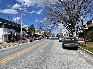
Hockessin is a census-designated place (CDP) in New Castle County, Delaware, United States. The population was 13,527 at the 2010 census.
Newport is a town in New Castle County, Delaware, United States. It is on the Christina River. It is best known for being the home of colonial inventor Oliver Evans. The population was 1,055 at the 2010 census. Four limited access highways, I-95, I-295, I-495, and Delaware Route 141 intersect within one mile (1.6 km) of the town.
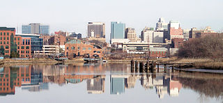
Wilmington is the largest city in the U.S. state of Delaware. The city was built on the site of Fort Christina, the first Swedish settlement in North America. It lies at the confluence of the Christina River and Brandywine Creek, near where the Christina flows into the Delaware River. It is the county seat of New Castle County and one of the major cities in the Delaware Valley metropolitan area. Wilmington was named by Proprietor Thomas Penn after his friend Spencer Compton, Earl of Wilmington, who was prime minister during the reign of George II of Great Britain.
Brandywine Hundred is an unincorporated subdivision of New Castle County, Delaware, United States. It is located to the north and northeast of the city of Wilmington. Hundreds were once used as a basis for representation in the Delaware General Assembly. Brandywine Hundred and North Wilmington are commonly used colloquial names for this area. However, while their names still appear on all real estate transactions, all other hundreds in Delaware presently have no meaningful use or purpose except as a geographical point of reference. In the 2010 census, Brandywine had 77,182 people.

Brandywine High School is a public secondary school located in Talleys Corner in unincorporated New Castle County, Delaware; despite not being in Wilmington, it has a Wilmington postal address. It is a part of the Brandywine School District.
Brandywine School District is a public school district in northern New Castle County, Delaware in the United States.

Delaware Route 141 (DE 141) is a state highway that serves as a western bypass of Wilmington, Delaware. Its southern terminus is at DE 9 and DE 273 in New Castle and its northern terminus is an interchange with U.S. Route 202 (US 202) and DE 261 near Fairfax. The route heads north from DE 9 and DE 273 on four-lane divided Basin Road, becoming concurrent with US 202 at an interchange with US 13/US 40 in Wilmington Manor and passes to the east of Wilmington Airport. The highway becomes a freeway and reaches an interchange with Interstate 95 (I-95) and I-295, at which point US 202 splits from DE 141. The DE 141 freeway continues north through Newport to Prices Corner. Here, the freeway segment ends and DE 141 continues northeast as a surface road, with another brief freeway segment in Greenville. The route heads east across the Brandywine Creek on the Tyler-McConnell Bridge and continues to US 202 and DE 261.

Delaware Route 92 (DE 92) is a 8.83-mile-long (14.21 km) road in northern New Castle County, Delaware, that runs a short distance to the south of the Pennsylvania/Delaware state line for most of its length. The route runs from DE 100 near Montchanin east to U.S. Route 13 (US 13) in Claymont. The road is a two-lane rural road between the western terminus and US 202, passing through Brandywine Creek State Park and the Brandywine Valley section of First State National Historical Park. East of US 202, DE 92 is a four-lane divided highway called Naamans Road that passes through suburban areas to the north of Wilmington, with an interchange at Interstate 95 (I-95) in Claymont. DE 92 was first built as a state highway east of US 202 during the 1920s and 1930s. By 1968, the route was designated onto its current alignment. In the 1990s, DE 92 east of US 202 was widened into a divided highway.

U.S. Route 202 (US 202) is a US Highway running from New Castle, Delaware, northeast to Bangor, Maine. The southernmost section of the route in the U.S. state of Delaware passes through northern New Castle County. It runs from its southern terminus at a partial cloverleaf interchange with US 13/US 40 near the Wilmington Airport north to the Pennsylvania state line in Brandywine Hundred. The route passes east of the airport concurrent with Delaware Route 141 (DE 141) before coming to an interchange with Interstate 95 (I-95). At this point, US 202 heads northeast along with I-95 through Wilmington. Just north of Wilmington, US 202 splits from I-95 by running north on Concord Pike through the suburban Brandywine Hundred area to the Pennsylvania state line. US 202 is a multilane divided highway the entire length across Delaware, with the section concurrent with I-95 a freeway.
Tavistock is an unincorporated community in New Castle County, Delaware, United States. It is within ZIP Code Tabulation Area for 19803.
Sharpley is an unincorporated community in New Castle County, Delaware, United States in the Brandywine Hundred. It is within ZIP Code Tabulation Area for 19803.
Edenridge is an unincorporated community in New Castle County, Delaware, United States in the Brandywine Hundred, north of Wilmington.

Woodbrook is a suburban community in New Castle County, Delaware, United States.
Stanton is an unincorporated community in New Castle County, Delaware, United States, near the confluence of the Red Clay and White Clay Creeks. It is located in the southern end of Mill Creek Hundred.
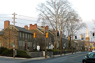
Brandywine Village Historic District is a national historic district located along Brandywine Creek at Wilmington, New Castle County, Delaware. It encompasses 12 contributing buildings, 7 contributing sites, and 2 contributing structures. Brandywine Village developed in the late-18th century as a group of flour mills, the homes of prosperous millers, mill workers, shop keepers and artisans. Located in the district are a set of mill owner built homes of granite. Notable buildings include the Gothic Revival style St. John's Episcopal Church (1857-1858) designed by noted Philadelphia architect John Notman, Brandywine Methodist Episcopal Church (1857), and Brandywine Academy (1798). In 1788, Brandywine Village was the site of the first mechanized mill designed by Oliver Evans.


