Related Research Articles

A ZIP Code is a system of postal codes used by the United States Postal Service (USPS). The term ZIP was chosen to suggest that the mail travels more efficiently and quickly when senders use the code in the postal address.
A census tract, census area, census district or meshblock is a geographic region defined for the purpose of taking a census. Sometimes these coincide with the limits of cities, towns or other administrative areas and several tracts commonly exist within a county. In unincorporated areas of the United States these are often arbitrary, except for coinciding with political lines.
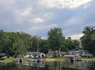
Canadian Lakes is an unincorporated community and census-designated place (CDP) in Mecosta County in the U.S. state of Michigan. The area is mostly within the southwest portion of Morton Township, southwest of Mecosta and east of Stanwood. As of the 2020 census, the CDP population was 3,202, up from 2,756 in 2010. The area defined by the CDP includes small portions in eastern Austin Township.

Carrollton Township is a civil township of Saginaw County in the U.S. state of Michigan. The population was 5,750 at the 2020 census. Established in 1866, Carrollton contains a full-time police department, fire department, parks and recreation services, as well as its own public school system, Carrollton Public Schools. Along with being located on the Saginaw River, Carrollton offers close access to shopping malls, medical facilities, Saginaw Valley State University, and I-75.
A census-designated place (CDP) is a concentration of population defined by the United States Census Bureau for statistical purposes only.

Topologically Integrated Geographic Encoding and Referencing, or TIGER, or TIGER/Line is a format used by the United States Census Bureau to describe land attributes such as roads, buildings, rivers, and lakes, as well as areas such as census tracts. TIGER was developed to support and improve the Bureau's process of taking the Decennial Census.

Thorofare is an unincorporated community and census-designated place (CDP) located within West Deptford Township in northwestern Gloucester County, situated in the South Jersey region of the U.S. state of New Jersey. The area is served as United States Postal Service ZIP Code 08086. As of the 2020 United States census, the CDP's population was 2,806. As of the 2000 census, the population of a different geographic entity containing Thorofare, namely ZIP Code Tabulation Area 08086, was 5,424.

Deepwater is an unincorporated community located within Pennsville Township, in Salem County, in the U.S. state of New Jersey. The community is located at the east end of the Delaware Memorial Bridge. Deepwater is the location of the United States Postal Service area covering ZIP code 08023. At the 2000 census, the ZCTA had a population of 345.
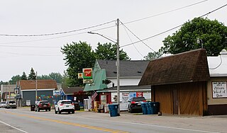
Linwood is a small unincorporated community in the northern portion of Bay County in the U.S. state of Michigan. The community is on the boundary between Fraser Township on the north and Kawkawlin Township on the south. It is situated with M-13 to the west and the Saginaw Bay of Lake Huron on the east, between Kaiser Tower Road and Elevator Road where Linwood Road becomes Center Street. Bay City is about 12 miles to the south and Linwood is included in the Bay City Metropolitan Statistical Area.
Hinkley is an unincorporated community in the Mojave Desert, in San Bernardino County, California, United States, 14 miles (23 km) northwest of Barstow, 59 miles (95 km) east of Mojave, 47 miles (76 km) north of Victorville and about a 120 mile (193 km) drive northeast of Los Angeles, just north of California State Route 58. The residents have faced concerns over hexavalent chromium in their well water from the world's largest plume of this cancer-causing chemical.
Address geocoding, or simply geocoding, is the process of taking a text-based description of a location, such as an address or the name of a place, and returning geographic coordinates, frequently latitude/longitude pair, to identify a location on the Earth's surface. Reverse geocoding, on the other hand, converts geographic coordinates to a description of a location, usually the name of a place or an addressable location. Geocoding relies on a computer representation of address points, the street / road network, together with postal and administrative boundaries.

Stirling is an unincorporated community and census-designated place (CDP) located within Long Hill Township in Morris County, in the U.S. state of New Jersey. The area is served as United States Postal Service ZIP Code 07980.
New Gretna is an unincorporated community and census-designated place (CDP) located within Bass River Township in Burlington County, in the U.S. state of New Jersey. The area is served as United States Postal Service ZIP Code 08224.

Indian Wells is a census-designated place in Navajo County, Arizona, United States. Indian Wells Elementary School is located in the town, it serves 600 students. It is also the name of the local Navajo chapter of the Navajo Nation Council. Indian Wells is served by a post office with the ZIP code of 86031. The ZIP Code Tabulation Area for ZIP Code 86031 had a population of 1,856 at the 2010 census, with 255 in Indian Wells itself.

New Monmouth is an unincorporated community located within Middletown Township in Monmouth County, in the U.S. state of New Jersey. The area is served as United States Postal Service ZIP Code 07748.
Hager Hill (also Hagerhill) is an unincorporated community in Johnson County, Kentucky, United States. Hager Hill is located approximately four miles south of Paintsville, the county seat of Johnson County.
Varney is an unincorporated community in Pike County, Kentucky, United States. Its ZIP Code is 41571; the population of the 41571 ZIP Code Tabulation Area (ZCTA) was 543 at the 2000 census.
Seabrook is an unincorporated community located within Upper Deerfield Township in Cumberland County, in the U.S. state of New Jersey. The area is served as United States Postal Service ZIP code 08302. The unincorporated community and the census-designated Place Seabrook Farms within it are each named after Charles F. Seabrook, a businessman who at one point ran the largest irrigated truck farm in the world in this region.
Monroeville is an unincorporated community located within portions of Elk Township in Gloucester County and Upper Pittsgrove Township in Salem County, in the U.S. state of New Jersey. The area is served as United States Postal Service ZIP Code 08343. Monroeville is mostly filled with wooded areas and farms.

Ocean View is an unincorporated community and census-designated place (CDP) located within Dennis Township in Cape May County, in the U.S. state of New Jersey. The area is served as United States Postal Service ZIP Code 08230. The post office was established in 1872, with William Doolittle as the first postmaster.
References
- ↑ "American Community Survey".
- ↑ ZIP Code Information, U.S. Census Bureau
- ↑ United States Census Bureau ZIP Code Tabulation Areas (ZCTAs)
- ↑ "U.S. Census Bureau data provided by GreatData.com" . Retrieved 5 February 2013.