
Protected areas of South Australia consists of protected areas located within South Australia and its immediate onshore waters and which are managed by South Australian Government agencies. As of March 2018, South Australia contains 359 separate protected areas declared under the National Parks and Wildlife Act 1972, the Crown Land Management Act 2009 and the Wilderness Protection Act 1992 which have a total land area of 211,387.48 km2 (81,617.16 sq mi) or 21.5% of the state's area.
Mount Greylock in northwest Massachusetts is the highest point in the state at 3,489 feet. The peak played a role in early American literature, and is part of the Taconic Mountains, which are geologically distinct from the nearby Berkshires and Green Mountains. Expansive views and a small area of sub-alpine forest characterize its upper reaches. A seasonal automobile road crosses the summit area near three structures from the 1930s which together constitute a small, "National Historic District." Various hiking paths including the Appalachian Trail traverse the area, which is part of the larger Mount Greylock State Reservation.
Burton Island State Park is a state park in northwest Vermont, USA. The park comprises Burton Island, an island of 253 acres (1 km2) and located off St. Albans Point in Lake Champlain, close to the International Boundary with Canada. The park is administered by the Vermont Department of Forests, Parks, and Recreation, as part of the Vermont State Park system.

Mount Tamalpais State Park is a California state park, located in Marin County, California. The primary feature of the park is the 2,571 feet (784 m) Mount Tamalpais. The park contains mostly redwood and oak forests. The mountain itself covers around 25,000 acres (100 km2). There are about 60 miles (97 km) of hiking trails, which are connected to a larger, 200-mile (320 km) network of trails in neighboring public lands. The park received 564,000 visitors as of 2003. Muir Woods National Monument is surrounded by the state park.
The protected areas of Michigan come in an array of different types and levels of protection. Michigan has five units of the National Park Service system. There are 14 federal wilderness areas; the majority of these are also tribal-designated wildernesses. It has one of the largest state forest systems as well having four national forests. The state maintains a large state park system and there are also regional parks, and county, township and city parks. Still other parks on land and in the Great Lakes are maintained by other governmental bodies. Private protected areas also exist in the state, mainly lands owned by land conservancies.

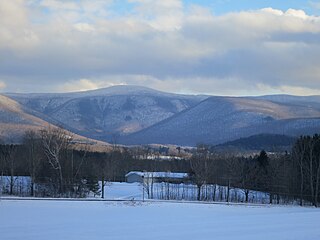
Lake Willoughby is a lake in the town of Westmore in Orleans County in the Northeast Kingdom of Vermont, United States.
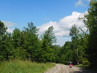
Hazen's Notch is a mountain pass in Westfield, in the northern Green Mountains of Vermont. Hazen's Notch was named after Moses Hazen, who in 1779 led the construction of the Bayley Hazen Military Road. The road was planned to extend from Newbury, Vermont, to Saint-Jean-sur-Richelieu, Quebec, not far from Montreal, to facilitate an invasion of Canada during the American Revolutionary War; it had reached this point when construction stopped.

The Bay Circuit Trail and Greenway or Bay Circuit is a Massachusetts rail trail and greenway connecting the outlying suburbs of Boston from Plum Island in Newburyport to Kingston Bay in Duxbury, a distance of 200 miles (320 km).

Smugglers' Notch State Park is a Vermont state park near Stowe in Lamoille County, Vermont, United States. The park is at an elevation of 2,119 feet (646 m) near Mount Mansfield, and is named for Smugglers Notch, which separates Mount Mansfield—the highest peak of the Green Mountains—from Spruce Peak and the Sterling Range.
Woods Island State Park is a state park on Lake Champlain in Vermont. The park comprises the 125-acre Woods Island, and is located off St. Albans Point in Franklin County, Vermont. It is administered by the Vermont Department of Forests, Parks, and Recreation, as part of the Vermont State Park system. The park can only be reached by boat, and visitors must make their own arrangements to get there. There is no dock.
Knight Island State Park is a state park near North Hero, Vermont comprising most of 125-acre Knight Island on Lake Champlain, except for 10 acres on the southern tip that are private. The park is administered by the Vermont Department of Forests, Parks, and Recreation, as part of the Vermont State Park system. The park can only be reached by boat, and visitors must make their own arrangements to get there. There is no dock.
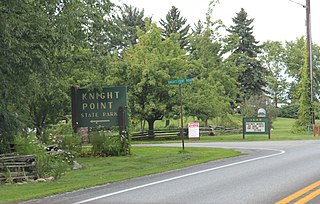
Knight Point State Park is a day use state park off US Route 2 on North Hero Island in North Hero, Vermont. Opened in 1978, the park is administered by the Vermont Department of Forests, Parks, and Recreation, as part of the Vermont State Park system. Features include a sandy swimming beach and boat rentals on Lake Champlain, and picnic areas with cooking grills.

Groton State Forest covers 26,164 acres (105.88 km2) in Danville, Groton, Marshfield, Orange, Peacham, Plainfield, Topsham, Vermont. The forest covers areas in Caledonia, Orange, and Washington Counties. Major roads through the forest are U.S. Route 302 and Vermont Route 232.

Willoughby State Forest covers 7,682 acres (31.09 km2) in Newark, Sutton and Westmore in Caledonia and Orleans counties in Vermont. The forest is managed by the Vermont Department of Forests, Parks, and Recreation. Activities include hiking, primitive camping, cross country skiing, snowshoeing, hunting and fishing.

Mount Mansfield State Forest covers 44,444 acres (179.86 km2) in seven towns in Chittenden, Lamoille and Washington counties in Vermont. The towns are Bolton and Underhill in Chittenden County, Cambridge, Johnson, Morristown and Stowe in Lamoille County, and Waterbury in Washington County. Mt. Mansfield State Forest is the largest contiguous landholding owned by the Vermont Department of Forests, Parks and Recreation.

Molly's Falls Pond State Park is a 1,064-acre state park in Cabot and Marshfield, Vermont surrounding 411-acre Molly's Falls Pond, a reservoir that is also known as Marshfield Reservoir. This is an undeveloped, day-use park. There is a Vermont Fish and Wildlife access area at the northwest end of the park with a concrete boat ramp and two fishing platforms for shore fishing.

The protected areas of North Carolina cover roughly 3.8 million acres, making up 11% of the total land in the state. 86.5% of this protected land is publicly owned and is managed by different federal and state level authorities and receive varying levels of protection. Some areas are managed as wilderness while others are operated with acceptable commercial exploitation. The remainder of the land is privately owned, but willingly entered into conservation easement management agreements, or are owned by various nonprofit conservation groups such as the National Audubon Society and The Nature Conservancy. North Carolina contains 1 National Park, and various other federally owned protected land including 2 National Seashores, 5 National Forests, 12 Wildlife Refuges, and the southern half of the Blue Ridge Parkway. North Carolina has an extensive state park system of 42 open units, 35 of which are state parks, 4 that are recreation areas, and 3 staffed state natural areas, along with other designated units managed by the North Carolina Department of Natural and Cultural Resources.
