
North Dakota State Parks (Hover mouse over pog to popup clickable link: green=state parks; red=recreation areas; black=historic sites.)
North Dakota state parks are state parks managed by the North Dakota Parks and Recreation Department.
North Dakota state parks are state parks managed by the North Dakota Parks and Recreation Department.
| Name | County | Area [1] | Estab- lished | Lake / river | Image | Remarks |
|---|---|---|---|---|---|---|
| Beaver Lake State Park | Logan | 273.16 acres (110.54 ha) | 1932 | Beaver Lake | 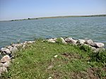 | Boating, fishing, camping |
| Butte Saint Paul State Recreation Area | Bottineau | 51.23 acres (20.73 ha) | 1933 | Turtle Mountains vista point | ||
| Cross Ranch State Park | Oliver | 569.07 acres (230.29 ha) | 1989 | Missouri River | 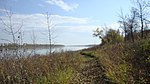 | Boating, canoeing, camping |
| Crow Flies High State Recreation Area | Mountrail | 247.11 acres (100.00 ha) | Lake Sakakawea | 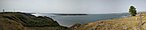 | Scenic lake views | |
| Fort Abraham Lincoln State Park | Morton | 836.47 acres (338.51 ha) | 1907 | Heart River, Missouri River |  | Home to On-A-Slant Indian Village |
| Fort Ransom State Park | Ransom | 933.78 acres (377.89 ha) | 1976 | Sheyenne River | 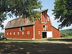 | Preserved homesteader farms |
| Fort Stevenson State Park | McLean | 586.48 acres (237.34 ha) | 1974 | Lake Sakakawea | 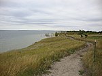 | Includes Fort Stevenson State Park Arboretum |
| Grahams Island State Park | Ramsey | 959.33 acres (388.23 ha) | 1988 | Devils Lake | Last remaining unit of the four former Devils Lake State Parks | |
| Icelandic State Park | Pembina | 930.3 acres (376.5 ha) | 1964 | Lake Renwick | 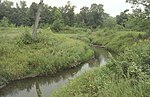 | Includes the Gunlogson Arboretum Nature Preserve |
| Lake Metigoshe State Park | Bottineau | 1,508.53 acres (610.48 ha) | 1937 | Lake Metigoshe | Adjacent to Turtle Mountain Provincial Park, Manitoba | |
| Lake Sakakawea State Park | Mercer | 739.52 acres (299.27 ha) | 1965 | Lake Sakakawea |  | Adjacent to Garrison Dam |
| Lewis and Clark State Park | Williams | 524.81 acres (212.38 ha) | 1973 | Lake Sakakawea | Fishing, boating, camping | |
| Little Metigoshe State Recreation Area | Bottineau | 1937 | Lake Metigoshe | Picnicking, fishing | ||
| Little Missouri State Park | Dunn | 6,492.93 acres (2,627.60 ha) | 1971 | Little Missouri River | Badlands hiking and equestrian trails | |
| Pelican Point State Recreation Area | Bottineau | 25.22 acres (10.21 ha) | Lake Metigoshe | Undeveloped day-use area | ||
| Pembina Gorge State Recreation Area | Cavalier | 1,236.98 acres (500.59 ha) | 2012 | Pembina River | River kayaking; trails for hiking, horseback riding, and off-road vehicles | |
| Sully Creek State Park | Billings | 63.03 acres (25.51 ha) | 1970 | Little Missouri River | Start of the Maah Daah Hey Trail | |
| Turtle River State Park | Grand Forks | 775.28 acres (313.74 ha) | 1934 | Turtle River |  | Camping, fishing, trails |
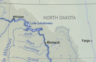
Lake Sakakawea is a large reservoir in the north central United States, impounded in 1953 by Garrison Dam, a U.S. Army Corps of Engineers dam located in the Missouri River basin in central North Dakota. Named for the Shoshone-Hidatsa woman Sakakawea, it is the largest man-made lake located entirely within the State of North Dakota, the second largest in the United States by area after Lake Oahe, and the third largest in the United States by volume, after Lake Mead and Lake Powell.

Lake Oahe is a large reservoir behind Oahe Dam on the Missouri River; it begins in central South Dakota and continues north into North Dakota in the United States. The lake has an area of 370,000 acres (1,500 km2) and a maximum depth of 205 ft (62 m). By volume, it is the fourth-largest reservoir in the US. Lake Oahe has a length of approximately 231 mi (372 km) and has a shoreline of 2,250 mi (3,620 km). 51 recreation areas are located along Lake Oahe, and 1.5 million people visit the reservoir every year. The lake is named for the 1874 Oahe Indian Mission.

Fort Abraham Lincoln State Park is a North Dakota state park located 7 miles (11 km) south of Mandan, North Dakota, United States. The park is home to the replica Mandan On-A-Slant Indian Village and reconstructed military buildings including the Custer House.

Zippel Bay State Park is a state park in Lake of the Woods County, Minnesota in the United States. It is on the white sand beach shoreline of the Lake of the Woods, near the United States border with Canada. The park is open for year-round recreation including camping, hiking, fishing and cross-country skiing.

Turtle Mountain, or the Turtle Mountains, is an area in central North America, in the north-central portion of the U.S. state of North Dakota and southwestern portion of the Canadian province of Manitoba, approximately 100 km south of the city of Brandon on provincial highway 10. It is a plateau 2,000 ft above sea level, 300 ft to 400 ft above the surrounding countryside, extending 20 mi (32 km) from north to south and 40 mi (64 km) from east to west. Rising 1,031 feet, North Dakota's most prominent peak, Boundary Butte, is located at the western edge of the plateau.

Beaver Lake State Park is a public recreation area located in Logan County, North Dakota, about equidistant from Napoleon and Wishek. The state park occupies 273 acres (110 ha) of land on the western shore of 968-acre (392 ha) Beaver Lake and offers hiking, boating, swimming, fishing, cabins, and campground.
Grahams Island State Park is a protected area of North Dakota, United States. It occupies 959 acres (388 ha) on the eastern flank of Grahams Island in Devils Lake. At one time there were four recreational units on the lake, collectively known as Devils Lake State Parks, but rising water caused three units to be closed. As of 2020, only Grahams Island State Park remained in operation. The park offers fishing, boating, picnicking, campsites, and cabins.

Lake Francis Case is a large reservoir impounded by Fort Randall Dam on the Missouri River in south-central South Dakota, United States. The lake has an area of 102,000 acres (410 km2) and a maximum depth of 140 ft (43 m). Lake Francis Case has a length of approximately 107 mi (172 km) and has a shoreline of 540 mi (870 km). The lake is the eleventh-largest reservoir in the United States and is located within the counties of: Charles Mix, Gregory, Lyman, Brule, and Buffalo. The lake stretches from Pickstown, South Dakota upstream to Big Bend Dam.

Fort Ransom State Park is a public recreation area located in the Sheyenne River Valley two miles north of the town of Fort Ransom in Ransom County, North Dakota. The state park preserves two homesteader farms: the Bjone House and the Andrew Sunne farm. The park is a featured site on the Sheyenne River Valley National Scenic Byway.
Lake Metigoshe State Park is a public recreation area occupying some 1,500 acres (610 ha) on the shores of Lake Metigoshe in the Turtle Mountains, 14 miles northeast of Bottineau, North Dakota, on the Canada–US border. The state park lies adjacent to the southwest corner of the much larger Turtle Mountain Provincial Park in Manitoba. A small portion of the lake extends northward into the Rural Municipality of Winchester but is not part of either park.
Little Missouri State Park is a public recreation area of over 6,000 acres (2,400 ha) located on the western side of the Little Missouri River, near the river's confluence with Lake Sakakawea, ten miles (16 km) north of Killdeer, North Dakota. Much of the state park consists of badlands terrain that is only accessible by trail. The park has more than 45 miles (72 km) of trails as well as campgrounds for hiking and equestrian use. The majority of the park's area is managed under lease from federal and private owners.

Fort Stevenson State Park is a public recreation area located on a peninsula on Lake Sakakawea four miles (6.4 km) south of the community of Garrison in McLean County, North Dakota. The state park's 586 acres (237 ha) include a partial reconstruction of Fort Stevenson, the 19th-century Missouri River fort from which the park takes its name. The site of the original fort lies about two miles southwest, below the waters of Lake Sakakawea.
Pelican Point State Recreation Area is an undeveloped unit of the North Dakota state park system located on Lake Metigoshe, ten miles (16 km) northeast of Bottineau. The recreation area's 25 acres (10 ha) are only accessible on foot; there are no developed trails.

Lake Sakakawea State Park is a public recreation area occupying 739 acres (299 ha) on the southern shore of Lake Sakakawea in Mercer County, North Dakota. The state park is located adjacent to the Garrison Dam, one mile (1.6 km) north of the community of Pick City.
Lewis and Clark State Park is a public recreation area occupying 525 acres (212 ha) on the north shore of the upper reaches of Lake Sakakawea 18 miles (29 km) east of Williston in Williams County, North Dakota. The state park offers fishing, boating, camping, and picnicking.
The Department of the Northwest was an U.S. Army Department created September 6, 1862 to put down the Sioux uprising in Minnesota. Major General John Pope was made commander of the Department. At the end of the Civil War the Department was redesignated the Department of Dakota. Immediately upon arriving in St. Paul General Pope sent letters to the Governors of Iowa and Wisconsin for additional troops to assist the 5th Minnesota Infantry Regiment. From Iowa he got the 27th Iowa Infantry Regiment and from Wisconsin he received the 25th Wisconsin Infantry Regiment. Both quickly crossed the border to assist with the uprising. The 25th Wisconsin was in Minnesota three months and the 27th Iowa was there a month before both headed south. After they departed, the Minnesota District would be garrisoned by Minnesota units: 5th, 6th, 7th, 8th, 9th, 10th Infantry Regiments, 1st and 2nd Minnesota Cavalry Regiments plus Minnesota Independent Cavalry Battalion as well as the 3rd Minnesota Light Artillery Battery. In 1864 companies of the 30th Wisconsin Infantry Regiment would see service in the Minnesota and Dakota Districts too.
Little Metigoshe State Recreation Area is a smaller unit of the North Dakota state park system located on the east shore of Lake Metigoshe in the Turtle Mountains near the international border between Canada and the United States. The area offers picnicking, fishing dock, and wintertime access to ice fishing. It lies one half mile west of the entrance to Lake Metigoshe State Park, a 1,500-acre facility that offers a full menu of recreational activities.
Lake Metigoshe is a 1,544-acre (625 ha) lake in both Bottineau County, North Dakota and the Rural Municipality of Winchester, Manitoba. The lake has a maximum depth of 24 feet (7.3 m). It is located in the Turtle Mountains on the Canada–United States border. The majority of the lake is within the United States, with only the northernmost tip in Canada. The Lake Metigoshe State Park encompasses a vast amount of shoreline around the lake. It offers swimming, canoeing, sailing, water-skiing and other water sports, modern and primitive camping areas, and picnicking. There is also the Skinautiques waterskiing club which is the only international waterskiing club in the United States.