Dakota Lake National Wildlife Refuge

Last updated

Dakota Lake National Wildlife Refuge is a National Wildlife Refuge in North Dakota. It is managed under Kulm Wetland Management District.

National Wildlife Refuge type of federal conservation area in the United States

National Wildlife RefugeSystem is a designation for certain protected areas of the United States managed by the United States Fish and Wildlife Service. The National Wildlife Refuge System is the system of public lands and waters set aside to conserve America's fish, wildlife, and plants. Since President Theodore Roosevelt designated Florida's Pelican Island National Wildlife Refuge as the first wildlife refuge in 1903, the system has grown to over 562 national wildlife refuges and 38 wetland management districts encompassing more than 150,000,000 acres (607,028 km2).

North Dakota State of the United States of America

North Dakota is a U.S. state in the midwestern and northern regions of the United States. It is the nineteenth largest in area, the fourth smallest by population, and the fourth most sparsely populated of the 50 states. North Dakota was admitted to the Union on November 2, 1889, along with its neighboring state, South Dakota. Its capital is Bismarck, and its largest city is Fargo.

Kulm Wetland Management District

Located in south-central North Dakota, Kulm Wetland Management District was established in 1971. Located in the Prairie Pothole Region of North America, Kulm Wetland Management District provides breeding, nesting, and brood rearing areas for many species of waterfowl and other migratory birds. The District currently manages 201 waterfowl production areas that total 45,683 acres (184.87 km2), 3 national wildlife refuges that are easement refuges, and 120,000 acres (490 km2) of wetland and grassland easements. The District's headquarters is in Kulm, North Dakota.

Dakota Lake National Wildlife Refuge was established by Executive Order 8117, signed on May 10, 1939 by President Franklin D. Roosevelt. The Refuge boundaries encompass 2,784 acres (11.27 km2) of private land. A system of flooding easements and management easements allows the Service flood land within the river channel or to restrict hunting, trapping and other harassment of wildlife.

Franklin D. Roosevelt 32nd president of the United States

Franklin Delano Roosevelt, often referred to by his initials FDR, was an American statesman and political leader who served as the 32nd president of the United States from 1933 until his death in 1945. A Democrat, he won a record four presidential elections and became a central figure in world events during the first half of the 20th century. Roosevelt directed the federal government during most of the Great Depression, implementing his New Deal domestic agenda in response to the worst economic crisis in U.S. history. As a dominant leader of his party, he built the New Deal Coalition, which realigned American politics into the Fifth Party System and defined American liberalism throughout the middle third of the 20th century. His third and fourth terms were dominated by World War II. Roosevelt is widely considered to be one of the most important figures in American history, as well as among the most influential figures of the 20th century. Though he has also been subject to much criticism, he is generally rated by scholars as one of the three greatest U.S. presidents, along with George Washington and Abraham Lincoln.

An easement is a nonpossessory right to use and/or enter onto the real property of another without possessing it. It is "best typified in the right of way which one landowner, A, may enjoy over the land of another, B". It is similar to real covenants and equitable servitudes; in the United States, the Restatement (Third) of Property takes steps to merge these concepts as servitudes.

Hunting Searching, pursuing, catching and killing wild animals

Hunting is the practice of killing or trapping animals, or pursuing or tracking them with the intent of doing so. Hunting wildlife or feral animals is most commonly done by humans for food, recreation, to remove predators that can be dangerous to humans or domestic animals, or for trade. Lawful hunting is distinguished from poaching, which is the illegal killing, trapping or capture of the hunted species. The species that are hunted are referred to as game or prey and are usually mammals and birds.

The District manages a low level dam on the James River called Dakota Lake Dam, also known as Ludden Dam or State Line Dam. Dakota Lake Dam was initially constructed by local people and the depression era Works Project Administration to raise the level of the James River, which frequently turned stagnant and toxic to cattle during summer months. The dam raises the level of the James River about one foot which holds water in old river channels, providing breeding, nesting and brood rearing habitat for many marsh dependent birds and other wildlife.

Cattle domesticated form of Aurochs

Cattle—colloquially cows—are the most common type of large domesticated ungulates. They are a prominent modern member of the subfamily Bovinae, are the most widespread species of the genus Bos, and are most commonly classified collectively as Bos taurus.

Marsh A wetland that is dominated by herbaceous rather than woody plant species

A marsh is a wetland that is dominated by herbaceous rather than woody plant species. Marshes can often be found at the edges of lakes and streams, where they form a transition between the aquatic and terrestrial ecosystems. They are often dominated by grasses, rushes or reeds. If woody plants are present they tend to be low-growing shrubs. This form of vegetation is what differentiates marshes from other types of wetland such as swamps, which are dominated by trees, and mires, which are wetlands that have accumulated deposits of acidic peat.

Dakota Lake National Wildlife Refuge is located in southern Dickey County, North Dakota. From Ludden, North Dakota proceed west on North Dakota Highway 11; the Refuge boundary is at the west end of town. North Dakota Highway 11 crosses the James River and the Refuge.

Dickey County, North Dakota County in the United States

Dickey County is a county in the U.S. state of North Dakota. As of the 2010 United States Census, the population was 5,289. Its county seat is Ellendale.

Ludden, North Dakota City in North Dakota, United States

Ludden is a city in Dickey County, North Dakota, United States. The population was 23 at the 2010 census. Ludden was founded in 1886.

The James River is at the heart of major corridor for migrating birds. The Refuge is a migration stopover for many thousands of waterfowl and shore birds. Snow geese are one of the most obvious users of the Refuge during their spring and fall migrations. Sand Lake National Wildlife Refuge in South Dakota is a scant 4 miles (6.4 km) south of Dakota Lake National Wildlife Refuge.

Snow goose species of bird

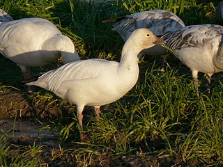
The snow goose, consisting of both a white phase and blue phase, is a North American species of goose commonly collectively referred to as "light geese". Its name derives from the typically white plumage. Many taxonomic authorities placed this species and the other "white geese" in the genus Chen. Most authorities now follow the traditional treatment of placing these species in the "gray goose" genus Anser. The scientific name is from the Latin anser, "goose", and caerulescens, "bluish", derived from caeruleus , "dark blue".

Sand Lake National Wildlife Refuge

Sand Lake National Wildlife Refuge is located in the northeastern part of the U.S. state of South Dakota and is administered by the U.S. Fish and Wildlife Service. Created in 1935, it is a wetlands of international importance and a Globally Important Bird Area. Over 260 bird species are found in the refuge, including many migratory bird species and the world's largest breeding colony of Franklin's gulls.

South Dakota State of the United States of America

South Dakota is a U.S. state in the Midwestern region of the United States. It is named after the Lakota and Dakota Sioux Native American tribes, who compose a large portion of the population and historically dominated the territory. South Dakota is the seventeenth largest by area, but the fifth smallest by population and the 5th least densely populated of the 50 United States. As the southern part of the former Dakota Territory, South Dakota became a state on November 2, 1889, simultaneously with North Dakota. Pierre is the state capital and Sioux Falls, with a population of about 187,200, is South Dakota's largest city.

Dakota Lake is closed to all public use; however, hunting, wildlife observation and photography can be quite good on public roads or private lands around the Refuge. April and October are good times to observe waterfowl migrations. An abundance of shorebirds migrate during late August and September.

Photography Art, science and practice of creating durable images by recording light or other electromagnetic radiation

Photography is the art, application and practice of creating durable images by recording light or other electromagnetic radiation, either electronically by means of an image sensor, or chemically by means of a light-sensitive material such as photographic film. It is employed in many fields of science, manufacturing, and business, as well as its more direct uses for art, film and video production, recreational purposes, hobby, and mass communication.

Related Research Articles

Bald Knob National Wildlife Refuge

The Bald Knob National Wildlife Refuge is a 15,022 acres (60.79 km2) (2014) wildlife refuge located in White County, Arkansas about two miles south of the town of Bald Knob. The refuge is managed by the United States Fish and Wildlife Service. The refuge features large numbers of migratory waterfowl and bald eagles during the winter months.

Big Lake National Wildlife Refuge

Big Lake National Wildlife Refuge is an 11,047-acre (45 km²) National Wildlife Refuge located in Mississippi County, Arkansas, managed by the United States Fish and Wildlife Service. It is situated 2 miles (3.2 km) east of Manila, Arkansas, and consists mostly of a shallow lake, swamp, and bottomland hardwood forests. The preservation of habitat for waterfowl in an intensely agricultural region is the primary purpose of the refuge. 6,400 acres (20 km²) of Big Lake is classified as a National Natural Landmark and 2,144 acres (8 km²) are classified as wilderness.

Shiawassee National Wildlife Refuge

The Shiawassee National Wildlife Refuge is a 9,870.35 acres (39.9439 km2) National Wildlife Refuge in Saginaw County managed by the United States Fish and Wildlife Service. It is located in the central portion of the lower peninsula of the U.S. state of Michigan, approximately 25 miles (40 km) south of the Saginaw Bay in Lake Huron and five miles (8 km) south of the city of Saginaw in the county's Spaulding and James townships. It was established in 1953 to provide habitat for migratory waterfowl.

Deep Fork National Wildlife Refuge

The Deep Fork National Wildlife Refuge (DFNWR) is part of the United States system of National Wildlife Refuges, and is a critical resource for wildfowl that migrate along the Central Flyway in Spring and Fall. It is located in Eastern Oklahoma, near the city of Okmulgee. The preserve runs along both banks of the Deep Fork River for about 20 miles (32 km). According to TravelOK, DFNWR receives about 45,000 visitors every year.

Browns Park National Wildlife Refuge

Browns Park National Wildlife Refuge is a 13,450-acre (5,440 ha) U.S. National Wildlife Refuge located in northwestern Colorado. It is located in Moffat County in the extreme northwestern corner of the state, in an isolated mountain valley of Browns Park on both sides of the Green River, approximately 25 miles (40 km) below Flaming Gorge Dam. Established in 1965, the refuge is managed by the United States Fish and Wildlife Service office in Maybell, Colorado. The refuge is approximately 53 miles (85 km) northwest of Maybell on State Highway 318. The refuge consists of bottomland and adjacent benchland. The western border of the refuge is the Colorado-Utah state line. The refuge is surrounded by adjacent lines of the Bureau of Land Management. The refuge contains the site of the former Fort Davy Crockett constructed in 1837 to protect trappers against attacks by Blackfoot Native Americans.

Choctaw National Wildlife Refuge

The Choctaw National Wildlife Refuge is a 4,218 acre (17.07 km²) National Wildlife Refuge located along the Tombigbee River near Coffeeville, Alabama. Named after the Choctaw tribe, it was established to provide a wood duck brood habitat and serve as a protected wintering area for waterfowl.

Arrowwood National Wildlife Refuge

Arrowwood National Wildlife Refuge is located in the U.S. state of North Dakota. Arrowwood NWR is a part of the Arrowwood National Wildlife Refuge Complex, and is managed by the U.S. Fish and Wildlife Service. The refuge parallels 16 miles (27 km) of the James River and is a mixture of wetlands, forest and prairie. Efforts to ensure the refuge continues to provide prime nesting habitat for waterfowl include prescribed fire, haying, crop cultivation and livestock grazing. The refuge has forests with oak and hackberry which are uncommon on the prairie. It is believed that the name for the refuge is derived from Native American naming for arrow wood, as the wood in the forest was prized for the making of arrows.

Arrowwood Wetland Management District

Arrowwood Wetland Management District is located in the U.S. state of North Dakota. Arrowwood WMD is a part of the Arrowwood National Wildlife Refuge Complex, and is managed by the U.S. Fish and Wildlife Service. The district consists of 28 Waterfowl Production Areas, 314 Wetland easements, one easement refuge known as Johnson Lake National Wildlife Refuge and another four easements through the Farmers Home Administration, altogether totalling 28,922 acres (117 km2).

Hobart Lake National Wildlife Refuge

Hobart Lake National Wildlife Refuge is a 2,077-acre (8.41 km2) Easement Refuge located in Barnes County, North Dakota five miles west of Valley City. The refuge is divided in half by Interstate Highway 94 running east and west. The United States Fish and Wildlife Service owns 277 acres (1.12 km2) in fee title and the remaining acres are covered by easement. Three nesting islands in the northeast corner of the refuge that were constructed by Ducks Unlimited have been submerged since 1993.

Chase Lake Wetland Management District

Chase Lake Wetland Management District is located in the U.S. state of North Dakota. The district is located in what is known as the prairie–potholes region of lakes and ponds, which were left behind by the retreat of glaciers at the end of the last ice age. Hundreds of waterfowl production areas, Wildlife Development Areas, wetland easements, grassland easements and the easement refuge known as Halfway Lake National Wildlife Refuge, are managed by the district. The district is a part of the Arrowwood National Wildlife Refuge Complex.

Catahoula National Wildlife Refuge

Catahoula National Wildlife Refuge, located in east central Louisiana, United States, 12 miles (19 km) east of Jena, was established in 1958 as a wintering area for migratory waterfowl. The refuge contains 25,162 acres (101.83 km2) divided into two units. The 6,671-acre (27 km2) Headquarters Unit borders nine miles (14 km) of the northeast shore of Catahoula Lake, a 26,000-acre (110 km2) natural wetland renowned for its large concentrations of migratory waterfowl. The 18,491-acre (74.83 km2) Bushley Bayou Unit, located 8 miles (13 km) west of Jonesville, was established May 16, 2001. This acquisition was made possible through a partnership agreement between The Conservation Fund, American Electric Power, and the Fish and Wildlife Service. The habitat found at the refuge is primarily lowland hardwood forest subject to seasonal backwater flooding from the Ouachita, and Red Rivers.

Cheyenne Bottoms

Cheyenne Bottoms is a wetland in the central Great Plains of North America. Occupying approximately 41,000 acres in central Kansas, it is the largest wetland in the interior United States. The Bottoms is a critical stopping point on the Central Flyway for millions of birds which migrate through the region annually.

Coldwater River National Wildlife Refuge

The Coldwater National Wildlife Refuge is located in northwest Mississippi, 4.5 miles (7.2 km) south of the town of Crowder. Established in 2000, this small refuge consists of 2,069 acres (837 ha) within an acquisition boundary of 16,000 acres (6,500 ha). The centerpiece of the refuge is 25 old catfish ponds ranging in size from 9 to 21 acres and totaling 495 acres (200 ha). These ponds are intensively managed for migrating waterfowl, shorebirds and wading birds. A majority of the refuge has been reforested in native bottomland hardwood species. Almost the entire refuge is flooded annually during the winter/spring by the Coldwater and Tallahatchie Rivers. Up to 50,000 migratory waterfowl winter on the refuge and 34 species of shorebirds have been recorded during spring and fall migration. Peregrine falcon, least tern, black tern, bald and golden eagles, and wood stork have been observed. Due to intensive management, the refuge is critically important as a sanctuary for waterfowl and other neotropical migratory birds. Primarily for these reasons, the refuge is closed to public access

Appert Lake National Wildlife Refuge

Appert Lake National Wildlife Refuge is a National Wildlife Refuge in Emmons County, North Dakota. It is a privately owned property with refuge easement rights for flooding, and is one of five easement refuges managed under Long Lake National Wildlife Refuge. It is closed to hunting. It was established to provide a stable water area and safe haven for migrating waterfowl in response to declining populations during the Dust Bowl era of the 1930s. The refuge centers on a wooded prairie wetland which provides relatively unique habitat in an agriculturally dominated area. The refuge is used by wood ducks, widgeon, teal, mallards, pintails, gadwalls and a host of woodland passerine bird species.

Bone Hill National Wildlife Refuge is a National Wildlife Refuge in North Dakota. It is managed under Kulm Wetland Management District.

Maple River National Wildlife Refuge is a National Wildlife Refuge in North Dakota. It is managed under Kulm Wetland Management District.

Canfield Lake National Wildlife Refuge is a National Wildlife Refuge in Burleigh County, North Dakota. It is a privately owned property with refuge easement rights for flooding with 3 acres owned in fee, and is one of six easement refuges managed under Long Lake National Wildlife Refuge. It is closed to hunting.

Summer Lake Wildlife Area

The Summer Lake Wildlife Area is a 29.6-square-mile (77 km2) wildlife refuge located on the northwestern edge of the Great Basin drainage in south-central Oregon. It is administered by the Oregon Department of Fish and Wildlife. The refuge is an important stop for waterfowl traveling along the Pacific Flyway during their spring and fall migrations. The Summer Lake Wildlife Area also provides habitat for shorebirds and other bird species as well as wide variety of mammals and several fish species. The Ana River supplies the water for the refuge wetlands.

References

PD-icon.svg This article incorporates  public domain material from websites or documents ofthe United States Fish and Wildlife Service .

Coordinates: 45°59′41″N98°09′46″W / 45.99472°N 98.16278°W / 45.99472; -98.16278