
Lake Norman State Park, formerly Duke Power State Park, is a 1,941-acre (7.85 km2) North Carolina state park near Troutman, Iredell County, North Carolina in the United States. The park is on the northern shore of Lake Norman at the mouth of Hicks Creek. The park is open for year-round recreation including, boating, fishing, water skiing, swimming and camping. Lake Norman State Park is on Inland Sea Road in Troutman just off U.S. Route 70 between Interstates 40 and 77.

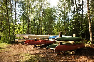
Turtle Mountain Provincial Park is a provincial park located in the southwestern portion of the Canadian province of Manitoba. Within it are the Adam Lake and Max Lake campgrounds. The park is known for its bike trails, fishing, back country cabins and canoe routes. The park is very popular with families and outdoor enthusiasts.

Fort Abraham Lincoln State Park is a North Dakota state park located 7 miles (11 km) south of Mandan, North Dakota, United States. The park is home to the replica Mandan On-A-Slant Indian Village and reconstructed military buildings including the Custer House.

Beaver Lake State Park is a public recreation area located in Logan County, North Dakota, about equidistant from Napoleon and Wishek. The state park occupies 283 acres (115 ha) of land on the western shore of 968-acre (392 ha) Beaver Lake and offers hiking, boating, swimming, fishing, cabins, and campground.

Devils Lake State Parks is the name sometimes applied to the units of the North Dakota state parks system located on Devils Lake, south of the city of Devils Lake in Ramsey County. As of 2017, only the larger remaining unit, 1,122-acre (454 ha) Grahams Island State Park, was in operation. The smaller Black Tiger Bay Recreation Area was closed due to inaccessibility. At one time there were four units on Devils Lake but rising water caused Narrows State Recreation Area to be closed in 1995 and Shelvers Grove's closure in 2004.

Pinckney State Recreation Area is a Michigan state recreation area in Dexter, Sylvan and Lyndon Townships, Washtenaw County and Putnam and Unadilla Townships, Livingston County in the U.S. state of Michigan. The park is 11,000 acres (4,500 ha) and sits at an elevation of 922 feet (281 m). The park is connected to the nearby Waterloo State Recreation Area by the 35-mile (56 km) Waterloo–Pinckney Trail. Pinckney State Recreation Area is open for year-round recreation including hiking, fishing, swimming, hunting and a variety of winter sports.
Erving State Forest is a publicly owned forest with recreational features located north of the Millers River in the towns of Erving, Warwick, and Orange, Massachusetts. The property is centered on Laurel Lake, a 51-acre (21 ha) body of water that has been a popular recreational destination since the 1930s. The forest's network of roads and hiking trails were largely created by the Civilian Conservation Corps. The forest is managed by the Department of Conservation and Recreation.
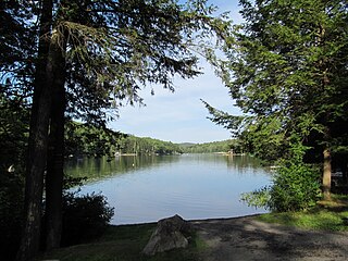
Lake Metigoshe State Park is a public recreation area occupying 1,551 acres (628 ha) on the shores of Lake Metigoshe in the Turtle Mountains, 14 miles northeast of Bottineau, North Dakota, on the Canada–US border. The state park lies adjacent to the southwest corner of the much larger Turtle Mountain Provincial Park in Manitoba. A small portion of the lake extends northward into the Rural Municipality of Winchester but is not part of either park.

Greenbrier State Park is a public recreation area located on South Mountain, three miles (4.8 km) northeast of Boonsboro in Washington County, Maryland, USA. The state park has camping, hiking trails, and a 42-acre (17 ha) man-made lake. It is managed by the Maryland Department of Natural Resources.

Lincoln Rock State Park is a public recreation area on the east side of the Columbia River's Lake Entiat, seven miles (11 km) north of Wenatchee and one mile upstream from the Rocky Reach Dam. The state park covers 86 acres (35 ha) opposite the cliff formation for which it is named. The park provides views of the south end of Swakane Canyon and of Turtle Rock Island in Lake Entiat, a 150-acre nature preserve that was isolated from the mainland when the lake formed in the 1960s. The park offers water activities, including fishing, boating, and swimming, in addition to facilities for picnicking, camping, hiking, and field sports. It is managed by the Washington State Parks and Recreation Commission under a lease agreement with the owners, the Chelan County Public Utility District.

Turtle River State Park is a public recreation area occupying 784 acres (317 ha) along the Turtle River north of the community of Arvilla in Grand Forks County, North Dakota. Park activities include camping, cross-country skiing, fishing, hiking, and mountain biking. The park also features an outdoor learning center.
Butte Saint Paul State Recreation Area is a 10-acre (4.0 ha) North Dakota state park unit located northwest of Dunseith in Bottineau County. The park encompasses 580-foot (180 m) Butte Saint Paul. A 12-foot (3.7 m) stone cairn and commemorative plaque sit atop the peak. Visitors can take in expansive views of the surrounding Turtle Mountain region.
Doyle Memorial State Recreation Area is a North Dakota state park located in McIntosh County, south of the community of Wishek. The park occupies a peninsula that juts into Green Lake and is used for fishing, boating, camping, and picnicking. The park lands were donated by and was named for J.J. Doyle who served in the North Dakota House of Representatives in 1909 and 1915.

Fort Stevenson State Park is a public recreation area located on a peninsula on Lake Sakakawea four miles (6.4 km) south of the community of Garrison in McLean County, North Dakota. The state park's 549 acres (222 ha) include a partial reconstruction of Fort Stevenson, the 19th-century Missouri River fort from which the park takes its name. The site of the original fort lies about two miles southwest, below the waters of Lake Sakakawea.
Pelican Point State Recreation Area is an undeveloped, day-use unit of the North Dakota state park system located on Lake Metigoshe, northeast of the community of Bottineau. The area is only accessible on foot; there are no developed trails.

Lake Sakakawea State Park is a public recreation area occupying 1,293 acres (523 ha) on the southern shore of Lake Sakakawea in Mercer County, North Dakota. The state park is located adjacent to the Garrison Dam, one mile (1.6 km) north of the community of Pick City.
Lewis and Clark State Park is a public recreation area occupying 490 acres (200 ha) on the north shore of the far western, upper reaches of Lake Sakakawea in Williams County, North Dakota. The state park, which is 19 miles east of Williston, is used for fishing, boating, camping, and picnicking.
Sully Creek State Park is a public recreation area located along the eastern banks of the Little Missouri River about 2 miles (3.2 km) south of Medora in Billings County, North Dakota. The state park is used for camping, horse camping, and canoeing. It was created in 1970.
Indian Hills State Recreation Area and Resort is a unit of the North Dakota state park system located on the north shore of Lake Sakakawea 31 miles (50 km) west of Garrison and operated as a commercial venture by a private leasee. The resort offers camping, lodging, boating, fishing, and trails for hiking and biking.
