Leipsic is a town in Kent County, Delaware, United States. It is part of the Dover, Delaware Metropolitan Statistical Area. The population was 183 at the 2010 census.

Woodside is a town in Kent County, Delaware, United States. It is part of the Dover, Delaware Metropolitan Statistical Area. The population was 181 at the 2010 census.

Bethel is a town in Sussex County, Delaware, United States. According to 2010 Census Bureau figures, the population of the town is 171. It is part of the Salisbury, Maryland-Delaware Metropolitan Statistical Area.

Fenwick Island is a coastal town in Sussex County, Delaware, USA. According to 2010 census figures, the population of the town is 379, a 10.8% increase over the last decade. It is part of the Salisbury, Maryland-Delaware Metropolitan Statistical Area. The town is located on Fenwick Island, a barrier spit.
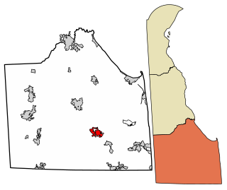
Millsboro is a town in Sussex County, Delaware. The Town is ranked #1 out of the 25 Sussex County cities for number of residential building permits issued - a leading indicator of population growth. The Town is part of the Salisbury, Maryland-Delaware Metropolitan Statistical Area.

Slaughter Beach is a town in Sussex County, Delaware, United States. The population was 207 at the 2010 census, an increase of 4.5% over the past decade. It is part of the Salisbury, Maryland-Delaware Metropolitan Statistical Area.

Folcroft is a borough in Delaware County, Pennsylvania, United States. The population was 6,606 at the 2010 census, down from 6,978 at the 2000 census.

Cape Henlopen is the southern cape of the Delaware Bay along the Atlantic coast of the United States. It lies in the state of Delaware, near the town of Lewes. Off the coast on the bay side are two lighthouses, called the Harbor of Refuge Light and the Delaware Breakwater East End Light.

Alloway Creek is a 23.2-mile-long (37.3 km) tributary of the Delaware River in Salem County, New Jersey in the United States. The name is a derivative of Allowas, an Indian chief. It has also been known by other names: Aloes River, Aloes Creek, Cotton River, Korten River, Short River, Monmouth River, Munmouth River, and Roiter's River.
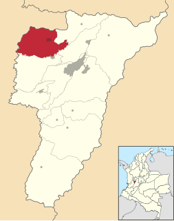
Quimbaya is a town and municipality in the western part of the department of Quindío, Colombia. It is 20 km northwest of the departmental capital Armenia. The name of the city derives from the name of the Precolumbian culture that inhabited the area, the Quimbaya civilization.
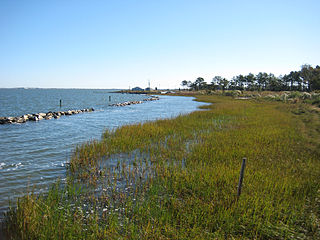
Indian River Bay is a body of water in Sussex County, Delaware. It is part of Delaware's inland bay system, along with Little Assawoman Bay and Rehoboth Bay. Fed by the Indian River at its western end, the bay is connected to the Atlantic Ocean to the east via the Indian River Inlet. A natural waterway that shifted up and down a two-mile stretch of the coast until 1928, the inlet was kept in its current location by dredging between 1928 and 1937, and in 1938 was fixed in place by the construction of jetties. The Charles W. Cullen Bridge, commonly known as the Indian River Inlet Bridge, spans the inlet.

Perry Lake is a US Army Corps of Engineers operated reservoir in northeast Kansas. Its primary purposes are flood control, water reserve for nearby areas and regional recreation. The lake is approximately 11,150 acres (45 km²) in size, with over 160 miles of shoreline. Perry Lake's full multi-purpose pool elevation is 891.5 feet above sea level. Perry Lake is located about 40 miles west of Kansas City, just northwest of Lawrence, Kansas. Its close proximity to Kansas City, Lawrence, and the state capitol, Topeka, make it a very popular destination, with the nickname "Paradise on the Plains".

Ballaugh is one of the seventeen parishes of the Isle of Man.

Clarksville is an unincorporated community in Baltimore Hundred, Sussex County, Delaware, United States located just west of Millville. It is centered, more or less, along Delaware Route 26. Many tourists from the Baltimore–Washington metropolitan area pass through the town on their way to and from the Delaware Beaches.

Woodland Beach Wildlife Area is a state wildlife area located in Kent County, Delaware, along shore of the Delaware Bay. It is 6,320 acres (2,558 ha) in size and is managed by Delaware Department of Natural Resources and Environmental Control (DNREC), Division of Fish & Wildlife.

Cedar Swamp Wildlife Area is a state wildlife area located in New Castle County, Delaware, along shore of the Delaware Bay. It is 5,515 acres (2,232 ha) in size and is managed by Delaware Department of Natural Resources and Environmental Control (DNREC), Division of Fish & Wildlife.
Nanticoke Wildlife Area is a state wildlife area located in Sussex County, Delaware, along the Nanticoke River and Broad Creek, near to Seaford, Delaware, and Bethel, Delaware. There is a monument commenmorating Captain John Smith's journey into the Chesapeake Bay and its tributaries at Phillips Landing along Broad Creek, a tributary of the Nanticoke River in Delaware. It is made up of three large land tracts totaling 4,510 acres (1,825 ha), it is managed by Delaware Department of Natural Resources and Environmental Control (DNREC), Division of Fish and Wildlife.
Old Furnace Wildlife Area is a state wildlife area located in Sussex County, Delaware, just to the east of the town of Seaford, Delaware. It is made up of four land tracts totalling 2,237 acres (905 ha), it is managed by Delaware Department of Natural Resources and Environmental Control (DNREC), Division of Fish and Wildlife.