Nez Perce National Historical Park

Last updated
Nez Perce National Historical Park
Bear Paw Battlefield.jpg
Usa edcp relief location map.png
Red pog.svg
Spalding
Location in the United States
USA Idaho relief location map.svg
Red pog.svg
Spalding
Location in Idaho
Location Idaho, Montana, Oregon,
Washington, United States
Nearest city Lewiston, Idaho
Coordinates 46°26′49″N116°49′23″W / 46.447°N 116.823°W / 46.447; -116.823 Coordinates: 46°26′49″N116°49′23″W / 46.447°N 116.823°W / 46.447; -116.823
Area4,561 acres (18.46 km2) [1]
EstablishedMay 15, 1965 (1965-May-15)
Visitors239,908(in 2016) [2]
Governing body National Park Service
Website Nez Perce National Historical Park

The Nez Perce National Historical Park is a United States National Historical Park comprising 38 sites located across the states of Idaho, Montana, Oregon, and Washington, which include traditional aboriginal lands of the Nez Perce people. The sites are strongly associated with the resistance of Chief Joseph and his band, who in June 1877 migrated from Oregon in an attempt to reach freedom in Canada and avoid being forced on to a reservation. They were pursued by U.S. Army cavalry forces and fought numerous skirmishes against them during the so-called Nez Perce War, which eventually ended with Chief Joseph's surrender in the Montana Territory.

Contents

Nez Perce National Historical Park was established in 1965, and a museum was opened at the park headquarters in Spalding, Idaho, in 1983. The 38 discontiguous sites span three main ecoregions, covering a wide range of elevations and climate. Numerous animal species inhabit the park areas, including several that are considered sensitive.

History

The park commemorates the history, culture, and stories of the Nez Perce. It includes sites associated with the Nez Perce War of 1877, when the people resisted takeover by the United States, and the flight of Chief Joseph and his band. The park is administered overall by the National Park Service, and a number of the sites are managed by other federal and state agencies as well as local communities; the park's headquarters are located in Spalding, Idaho, east of Lewiston.

The park was established by Congress in 1965. [3] [4] Construction of the planned headquarters site and museum at Spalding were delayed by land acquisition and federal funding problems. [5] [6] [7] Soon after construction began in September 1979, Native American graves were discovered at the site. Remains and artifacts were preserved in consultation with the Nez Perce. Construction of the visitor center and museum was later restarted. [8] The museum opened in June 1983. [9] [10]

Sites

The Nez Perce National Historic Park does not follow the format of most national parks, in that it is composed of dozens of sites spread over four states. The 38 sites are linked by the history of the Nez Perce people, rather than by geographic location. [11] Twenty-six of the sites are on or near the Nez Perce Indian Reservation in Idaho and can be toured in one day. Adjacent states hold the other twelve sites. [12]

Several of the sites are connected by the Nez Perce National Historic Trail, managed by the United States Forest Service. It preserves the route taken by Chief Joseph and his band when they tried to reach Canada in 1877. [11]

The sites include:

Ecology

The NPNHP sites cover three main ecoregions. The first, found at the sites in the Palouse grasslands and Missouri Basin, is shortgrass prairie. These flat or slightly rolling prairies include rivers and streams, and have an altitude of about 1,000 to 3,500 feet (300 to 1,070 m). The second, found in the plateaus of the Columbia and Snake rivers, is sagebrush steppe at around 3,000 ft in altitude; it includes lava fields and flows. The third, found in the sites in the Blue Mountains, Salmon River Mountains, southwestern Montana and northern Rocky Mountains, is conifer and alpine meadows. These high-elevation sites have lower temperatures and greater precipitation than the other ecoregions. [13]

Numerous species of mammals, amphibians, reptiles, birds and invertebrates inhabit the various park sites. Several of these species are classified in terms of their status as "threatened," "endangered" or "sensitive" at the state level. Montana Arctic grayling, mountain plover, swift fox, great grey owl, boreal owl and several fish species are all sensitive species that inhabit the park, while gray wolf and bald eagles are sometimes seen. [14] Managers of the park have several ecological concerns including issues of invasive plant species, the degradation of animal habitat due to human activity, the protection of endangered species, and dealing with effects of climate change. [15]

See also

Related Research Articles

<span class="mw-page-title-main">Nez Perce</span> Indigenous peoples of North America

The Nez Perce are an Indigenous people of the Plateau who are presumed to have lived on the Columbia River Plateau in the Pacific Northwest region for at least 11,500 years.

<span class="mw-page-title-main">Nez Perce County, Idaho</span> County in Idaho, United States

Nez Perce County is a county located in the U.S. state of Idaho. As of the 2020 census, the population was 42,090. The county seat is Lewiston. The county is named after the Native American Nez Percé tribe. Nez Perce County is part of the Lewiston, Idaho–WA Metropolitan Statistical Area.

<span class="mw-page-title-main">Lewis County, Idaho</span> County in Idaho, United States

Lewis County is a county located in the north central region of the U.S. state of Idaho. As of the 2020 census, the population was 3,533, making it the fourth-least populous county in Idaho. The county seat is Nezperce, and Kamiah is the largest city. Partitioned from Nez Perce County and established in 1911, it was named after the explorer Meriwether Lewis. Most of the county is within the Nez Perce Indian Reservation, though Native Americans comprise less than 6% of the county population. Similar to the opening of lands in Oklahoma, the U.S. government opened the reservation for white settlement in November 1895. The proclamation had been signed less than two weeks earlier by President Cleveland.

<span class="mw-page-title-main">Idaho County, Idaho</span> County in Idaho, United States

Idaho County is a county in the U.S. state of Idaho, and the largest by area in the state. As of the 2020 census, the population was 16,541. The county seat is Grangeville. Previous county seats of the area were Florence (1864–68), Washington (1868–75), and Mount Idaho (1875–1902).

<span class="mw-page-title-main">Chief Joseph</span> Native American leader (1840–1904)

Hin-mah-too-yah-lat-kekt, popularly known as Chief Joseph, Young Joseph, or Joseph the Younger, was a leader of the Wal-lam-wat-kain (Wallowa) band of Nez Perce, a Native American tribe of the interior Pacific Northwest region of the United States, in the latter half of the 19th century. He succeeded his father Tuekakas in the early 1870s.

<span class="mw-page-title-main">Nez Perce War</span> 1877 armed conflict between the U.S. Army and Native Americans in the Pacific Northwest

The Nez Perce War was an armed conflict in 1877 in the Western United States that pitted several bands of the Nez Perce tribe of Native Americans and their allies, a small band of the Palouse tribe led by Red Echo (Hahtalekin) and Bald Head, against the United States Army. Fought between June and October, the conflict stemmed from the refusal of several bands of the Nez Perce, dubbed "non-treaty Indians," to give up their ancestral lands in the Pacific Northwest and move to an Indian reservation in Idaho Territory. This forced removal was in violation of the 1855 Treaty of Walla Walla, which granted the tribe 7.5 million acres of their ancestral lands and the right to hunt and fish on lands ceded to the U.S. government.

<span class="mw-page-title-main">Lolo Pass (Idaho–Montana)</span> United States historic place

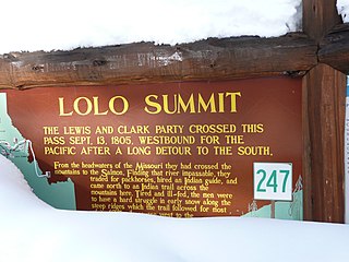
Lolo Pass, elevation 5,233 feet (1,595 m), is a mountain pass in the western United States, in the Bitterroot Range of the northern Rocky Mountains. It is on the border between the states of Montana and Idaho, approximately forty miles (65 km) west-southwest of Missoula, Montana.

<span class="mw-page-title-main">Camas prairie</span>

The name camas prairie refers to several different geographical areas in the western United States which were named for the native perennial camassia or camas. The culturally and scientifically significant of these areas lie within Idaho and Montana. Camas bulbs were an important food source for Native Americans.

<span class="mw-page-title-main">Spalding, Idaho</span> Unincorporated community in northern Nez Perce County, Idaho

Spalding is an unincorporated community in the northwest United States, located in northern Nez Perce County, Idaho.

<span class="mw-page-title-main">Big Hole National Battlefield</span> Historical battlefield in Montana, United States

Big Hole National Battlefield preserves a battlefield in the western United States, located in Beaverhead County, Montana. In 1877, the Nez Perce fought a delaying action against the U.S. Army's 7th Infantry Regiment here on August 9 and 10, during their failed attempt to escape to Canada. This action, the Battle of the Big Hole, was the largest battle fought between the Nez Perce and U.S. Government forces in the five-month conflict known as the Nez Perce War.

<span class="mw-page-title-main">Nez Perce National Historic Trail</span>

The Nez Perce (Nee-Me-Poo) National Historic Trail follows the route taken by a large group of the Nez Perce tribe in 1877 to avoid being forced onto a reservation. The 1,170-mile (1,883 km) trail was created in 1986 as part of the National Trails System Act and is managed by the U.S. Forest Service. The trail traverses through portions of the U.S. states of Oregon, Idaho, Wyoming, and Montana and connects sites across these states that commemorate significant events of the Nez Perce War that took place between June and October 1877, as several bands of the Nez Perce tried to escape capture by the U.S. Cavalry. The sites are among the 38 that are part of the National Park service's Nez Perce National Historical Park, managed over all by the National Park Service, with some sites managed by local and state affiliated organizations.

<span class="mw-page-title-main">Wallowa–Whitman National Forest</span> United States national forest in Oregon

The Wallowa–Whitman National Forest is a United States National Forest in the U.S. states of Oregon and Idaho. Formed upon the merger of the Wallowa and Whitman national forests in 1954, it is located in the northeastern corner of the state, in Wallowa, Baker, Union, Grant, and Umatilla counties in Oregon, and includes small areas in Nez Perce and Idaho counties in Idaho. The forest is named for the Wallowa band of the Nez Perce people, who originally lived in the area, and Marcus and Narcissa Whitman, Presbyterian missionaries who settled just to the north in 1836. Forest headquarters are located in Baker City, Oregon with ranger districts in La Grande, Joseph and Baker City.

<span class="mw-page-title-main">Old Chief Joseph Gravesite</span> United States historic place

The Old Chief Joseph Gravesite, also known as Nez Perce Traditional Site, Wallowa Lake, Chief Joseph Cemetery and Joseph National Indian Cemetery is a Native American cemetery near Joseph, Oregon. The area was also a traditional campsite of the Nez Perce and may be archaeologically significant. It was declared a National Historic Landmark in 1985, listed as Wallowa Lake Site. It is a component of the Nez Perce National Historical Park.

<span class="mw-page-title-main">Joseph Canyon</span>

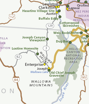
Joseph Canyon is a 2,000-foot (610 m)-deep basalt canyon in northern Wallowa County, Oregon, and southern Asotin County, Washington, United States.

<span class="mw-page-title-main">Weippe Prairie</span> United States historic place

Weippe Prairie is a "beautiful upland prairie field of about two by three miles bordered by farmland made from cleared pine forests" at 3,000 feet elevation in Clearwater County, Idaho, at Weippe, Idaho. Camas flowers grow well there, and attracted native gatherers of the camas roots. It is the location in Idaho where the Lewis and Clark Expedition emerged from crossing the Bitterroot Mountains on the Lolo Trail and first met the Nez Perce tribe of Native Americans.

<span class="mw-page-title-main">Idaho State Highway 11</span> State highway in Idaho, United States

Idaho State Highway 11 (SH-11) is a state highway in north central Idaho. It runs 42.481 miles (68.37 km) from U.S. Route 12 near Greer, north to Forest Service Roads 246 and 247 near Headquarters.

<span class="mw-page-title-main">U.S. Route 12 in Idaho</span> Section of U.S. Highway in Idaho, United States

U.S. Route 12 (US-12) is a United States Numbered Highway in North Central Idaho. It extends 174.410 miles (280.686 km) from the Washington state line in Lewiston east to the Montana state line at Lolo Pass, generally along the route of the Lewis and Clark Expedition, and is known as the Northwest Passage Scenic Byway. It was previously known as the Lewis and Clark Highway.

<span class="mw-page-title-main">Fort Lapwai</span> Historic fortification of the American Civil War in Idaho

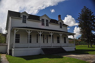
Fort Lapwai (1862–1884), was a federal fort in present-day Lapwai in north central Idaho, United States. On the Nez Perce Indian Reservation in Nez Perce County, it was originally called Camp Lapwai until 1863. East of Lewiston, it was located on the west bank of Lapwai Creek, three miles (5 km) above where it joins the Clearwater River at the state's first settlement, Lapwai Mission Station, built in 1836 by Henry Spalding. It is part of the multi-site Nez Perce National Historical Park. The word "Lapwai" means place of the butterflies, as the area had thousands in early summer in earlier years.

Nez Perce may refer to:

The Chief Joseph Trail Ride is an annual horse trail ride that follows the route the Nimiipuu took during the Nez Perce War in 1877. The trail in its entirety is 1,300 miles long, separated into thirteen separate rides, which take place sequentially. The ride is on a 13-year cycle. The trail ride was started in 1965 by the Appaloosa Horse Club.

References

  1. "Listing of acreage – December 31, 2011" (XLSX). Land Resource Division, National Park Service. Retrieved 2012-12-14. (National Park Service Acreage Reports)
  2. "NPS Annual Recreation Visits Report". National Park Service. Retrieved 2017-04-25.
  3. Hewlett, Frank (May 6, 1965). "Nez Perce historical park assured by Senate action". Spokemsan-Review. p. 12.
  4. "Senate quickly agrees on park bill changes". Lewiston Morning Tribune. (Idaho). May 6, 1965. p. 16.
  5. "Park acquires almost all land needed for headquarter site". Lewiston Morning Tribune. (Idaho). March 14, 1968. p. 16.
  6. Cameron, Mindy (May 17, 1970). "Nez Perce Park designation expected any day". Lewiston Morning Tribune. (Idaho). p. 11.
  7. "Federal economy ax falls on park visitor center". Lewiston Morning Tribune. (Idaho). February 22, 1973. p. 20.
  8. "Indian graves delay construction". Lewiston Morning Tribune. (Idaho). September 16, 1979. p. 2B.
  9. Lee, Sandra L. (March 30, 1983). "Nez Perce Park's visitor center to open about June 15". Lewiston Morning Tribune. (Idaho). p. 1C.
  10. "New visitor center opens at Spalding". Lewiston Morning Tribune. (Idaho). June 29, 1983. p. 14E.
  11. 1 2 "Nez Perce National Historic Park Sites". National Park Service. Retrieved 2013-12-05.
  12. Pia Hallenberg Christensen (September 14, 2008). "Nez Perce museum in Spalding, Idaho, a hub for tribe's history". Seattle Times.
  13. "Nature & Science". National Park Service. Retrieved 2013-12-05.
  14. "Animals". National Park Service. Retrieved 2013-12-05.
  15. "Environmental Factors". National Park Service. Retrieved 2013-12-05.