
Apra Harbor, also called Port Apra, is a deep-water port on the western side of the United States territory of Guam. It is considered one of the best natural ports in the Pacific Ocean. The harbor is bounded by Cabras Island and the Glass Breakwater to the north and the Orote Peninsula in the south. Naval Base Guam and the Port of Guam are the two major users of the harbor. It is also a popular recreation area for boaters, surfers, scuba divers, and other recreationalists.

Asan-Maina is a village located on the western shore of the United States territory of Guam. The municipality combines the names of the coastal community of Asan with Maina, a community along the slopes of the Fonte River valley to the east. Asan was the northern landing site for United States Marines during Guam's liberation from the Japanese during World War II. Asan Beach Park is part of the War in the Pacific National Historic Park. The third community comprising Asan-Maina is Nimitz Hill Annex in the hills above Asan and Maina, which is the location of the Joint Region Marianas headquarters. Asan-Maina is located in the Luchan (Western) District.

Piti is a village located on the central west coast of the United States territory of Guam. It contains northern and eastern coastlines of Apra Harbor, including Cabras Island, which has the commercial Port of Guam and the island's largest power plants. Piti was a pre-Spanish CHamoru village and, after Spanish colonization, became the primary port town on Guam. The town was largely destroyed during the 1944 liberation of Guam and the population relocated during the wartime construction of Apra Harbor.

Guam Highway 1 (GH-1), also known as Marine Corps Drive, is one of the primary automobile routes in the United States territory of Guam. It runs in a southwest-to-northeast direction, from the main gate of Naval Base Guam in the southwestern village of Santa Rita in a northeasterly direction to the main gate of Andersen Air Force Base in the village of Yigo. It passes through Guam's capital, Hagåtña, as well as intersecting other territorial highways. The highway runs through tropical forest, urbanized commercial areas, and residential neighborhoods. The US military upgraded and extended the road starting in 1941. Construction ceased with the Japanese invasion in December 1941 and resumed after the Second Battle of Guam in 1944. The highway was formally dedicated to the U.S. Marine Corps by the governor in 2004.

Nimitz Hill Annex is a community and census-designated place (CDP) in Asan-Maina, Guam. It contains the geographic feature of Nimitz Hill, and is located immediately northeast of the Nimitz Hill CDP in Piti. In normal conversation, the Nimitz Hill CDP and Nimitz Hill Annex CDP are often collectively referred to as "Nimitz Hill."

Agat Bay is a bay on the west coast of Guam. Its northern boundary is the Orote Peninsula, occupied entirely by Naval Base Guam, which itself lies within the village of Sånta Rita-Sumai. The bay stretches south along the coast of the village of Hågat to Facpi Point. With a length of some seven kilometers, the bay stretches for nearly one fifth of the west coast of Guam. The Asan Invasion Beach of the 1944 Battle of Guam is commemorated by the Agat Unit of War in the Pacific National Historical Park, which spans surce and subsurface areas from Apaca Point to Bangi Point. The NRHP-listed Agat World War II Amtrac is submerged off Agat Cemetery.
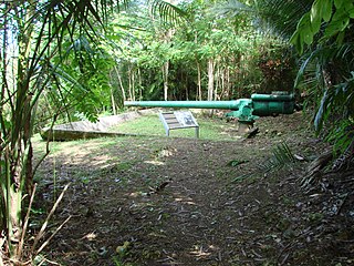
The Piti Guns or Piti Coastal Defense Guns is the site of three Vickers-type Model 3 140-millimetre (5.5 in) coastal defense guns in the War in the Pacific National Historical Park in Piti, Guam. The Japanese manufactured these Model 3 coastal defense guns in 1914. During the Japanese Occupation of Guam from 1941 to 1944, they built up defensive positions on the island. The Chamorro population was forced to work in building up these defenses, and did so here at the Piti Guns.
The Asan River is a river in the United States territory of Guam that lies entirely within the village of Asan-Maina. It originates in the highlands of Nimitz Hill Annex and flows through the Asan Inland Unit of War in the Pacific National Historical Park (WAPA) and enters the community of Asan. It then briefly re-enters WAPA at its Asan Inland Unit, with the mouth at the eastern end of Asan Memorial Park into Asan Bay. The river was thus a significant geographical feature of the Asan Invasion Beach for U.S. forces during the initial landings on Guam in July 1944.
The Guam Department of Parks and Recreation operates public parks in Guam. The agency has its headquarters in Agana Heights.

The Agat Invasion Beach is a historic site in the village of Agat, Guam. The beaches of Agat were one of the landing sites of American forces in the 1944 Battle of Guam, in which the island was retaken from occupying Japanese forces. The designated historic site includes the beaches and inland areas extending between Bangi Point and Togcha Beach. Surviving remnants of the Japanese defenses on this stretch of coast include trenches and rifle pits located a short way inland, and a fortified bunker and 40mm gun emplacements at Ga'an Point. Remnants of pillboxes that had lined the beach also survive, with one at Gangi Point in relatively good condition.

The Agat World War II Amtrac is an underwater relic of World War II, located off Ga'an Point in Agat Bay on the west side of the island of Guam. It is the remains of an LVT 4, an amphibious tracked landing vehicle. It is located about 500 yards (460 m) off Agat Invasion Beach in 45 feet (14 m) of water, and was described as being in good condition when it was discovered and surveyed in 1985. These vehicles were used during the 1944 Battle of Guam, in which American forces recaptured the island from occupying Japanese forces. This particular vehicle does not appear to exhibit significant war damage. This is the most intact of the three Amtracks remaining on Guam from the 850 that participated in the battle. It was re-surveyed by maritime archaeological field schools conducted from 2009 to 2012.

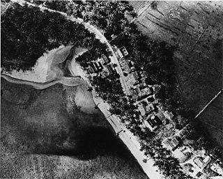
The Asan Invasion Beach is a historic site in the village of Asan, Guam. The beaches of Asan were one of the landing sites of American forces in the 1944 Battle of Guam, in which the island was retaken from occupying Japanese forces. The designated historic site includes the beaches extending between Asan Point and Adelup Point, and extends inland roughly to Guam Highway 1. It also includes the water area extending from the beach to the reef, about 100 metres (330 ft) out, an area that includes at least one abandoned Allied landing vehicle.
The Asan Ridge Battle Area was the scene of some of the heaviest fighting in the 1944 Battle of Guam, the World War II battle in which Allied forces recaptured Guam from occupying Japanese forces. The area is now part of the Asan Inland Unit of the War in the Pacific National Historical Park, and was listed on the National Register of Historic Places in 1975. The area is just inland of the Asan Invasion Beach, one of the two major beachheads established by the Allies, and has a commanding view over that area. The landforms included in this area are Chorrito Cliff, Bundschuh Ridge, and Nimitz Hill, and they were heavily fortified by the Japanese prior to the battle. Surviving elements of these fortifications include two concrete pillboxes, and an unfinished battery of 4-inch guns.

Sumay, also Sumai, was a village on the United States territory of Guam. It was located on the north coast of the Orote Peninsula along Apra Harbor. It was inhabited by Chamorro people before contact with Europeans. Sumay became a prosperous port town serving whalers and other sailors in the 1800s and the second most populous settlement on Guam after Hagåtña, the capital of the Spanish Mariana Islands. Following the Capture of Guam by the United States in 1898, the village was the site of Marine Barracks Guam. In the early 1900s, it was a link for two firsts connecting the United States and Asia: the first submarine communications cable for telegraph and the China Clipper, the first air service. After the Japanese invasion of Guam in 1941, the residents were evicted and the village turned into a Japanese military garrison. Sumay was leveled during the U.S. liberation of the island in 1944. The U.S. military prohibited the residents from returning, relocating them to the hills of nearby Sånta Rita-Sumai. In 1948, the U.S. military exercised eminent domain and took all private and commercial property at Sumay. Its former location is now on Naval Base Guam.
Nimitz Hill is a community and census-designated place (CDP) in Piti, Guam. is located immediately west of the Nimitz Hill Annex CDP in Asan-Maina, which contains the geographic feature of Nimitz Hill. In normal conversation, the Nimitz Hill CDP and Nimitz Hill Annex CDP are often collectively referred to as "Nimitz Hill."
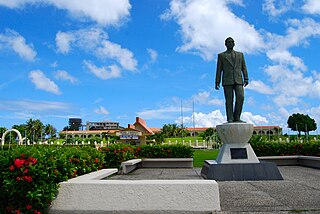
Adelup Point is limestone promontory in Hagåtña, Guam that extends into the Philippine Sea and separates Asan Bay from Hagåtña Bay. It has been the site of the Ricardo J. Bordallo Governor's Complex since 1990. Adelup is therefore a metonym for the Office of the Governor of Guam.

Liberation Day on the U.S. territory of Guam is an annual commemoration of the invasion by U.S. military forces on July 21, 1944, which ended the Japanese occupation that had begun in 1941. Begun in 1945, it is Guam's largest celebration. Festivities include a queen contest, summer carnival, fireworks display, and mile-long parade on Marine Corps Drive in Hagåtña from Adelup to Paseo de Susana, as well as solemn memorials and visits to massacre sites. It is organized by the Guam Island Fair Committee.
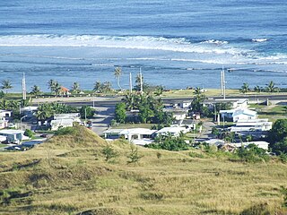
Asan is a community and census-designated place (CDP) along the western coast of the U.S. territory of Guam. Asan, along with Maina and Nimitz Hill Annex, are the three communities in the village of Asan-Maina. It is known for being the location of northern invasion beach used by the United States during the retaking of Guam in 1944.


