Harpers Ferry National Historical Park

Last updated

Harpers Ferry National Historical Park
2010-09-02-Harpers-Ferry-From-Maryland-Heights-Panorama-Crop.jpg
Shenandoah River on left and Potomac River on right merge at Harpers Ferry
USA West Virginia relief location map.svg
Red pog.svg
USA Virginia relief location map.svg
Red pog.svg
USA Maryland relief location map.svg
Red pog.svg
Usa edcp relief location map.png
Red pog.svg
Location Maryland, Virginia, and West Virginia
Coordinates 39°19′22″N77°43′47″W / 39.32278°N 77.72972°W / 39.32278; -77.72972
Area3,660.73 acres (14.8144 km2) [1]
EstablishedJune 30, 1944 (1944-06-30)
Visitors407,008(in 2022) [2]
Governing body National Park Service
Website Harpers Ferry National Historical Park
Harpers Ferry National Historical Park
LocationConfluence of the Potomac and Shenandoah rivers
Harpers Ferry, West Virginia
NRHP reference No. 66000041 [3]  (original)
16000238  (increase)
Significant dates
Added to NRHPOctober 15, 1966
Boundary increaseMay 10, 2016

Harpers Ferry National Historical Park, originally Harpers Ferry National Monument, is located at the confluence of the Potomac and Shenandoah rivers in and around Harpers Ferry, West Virginia. The park includes the historic center of Harpers Ferry, notable as a key 19th-century industrial area and as the scene of John Brown's failed abolitionist uprising. It contains the most visited historic site in the state of West Virginia, John Brown's Fort. [4]

Contents

The park includes land in the Shenandoah Valley in Jefferson County, West Virginia; Washington County, Maryland and Loudoun County, Virginia. The park is managed by the National Park Service, an agency of the U.S. Department of the Interior. Originally designated Harpers Ferry National Monument in 1944, the park was declared a National Historical Park by the U.S. Congress in 1963. Consisting of almost 4,000 acres (16 km2), it includes the site of which Thomas Jefferson once wrote, "The passage of the Potomac through the Blue Ridge is perhaps one of the most stupendous scenes in Nature" after visiting the area in 1783. [5] Due to a mixture of historical events and ample recreational opportunities, all within 50 miles (80 km) of Washington, D.C., the park was listed on the National Register of Historic Places on October 15, 1966. [6] In 2017, the Park's Superintendent was Tyrone Brandyburg. [7]

The park was originally planned as a memorial to John Brown, responsible for what is by far the most famous incident in Harpers Ferry's history, his 1859 raid and capture of the federal armory. NPS officials in the 1930s focused on John Brown's raid and the Civil War to justify acquiring parts of Harpers Ferry for a historical and military park. This was opposed by organizations such as the United Daughters of the Confederacy and the Sons of Confederate Veterans. [8] :86

Early history

Native American history in the region dates back to at least 8,000 years ago. The Tuscarora people were the last of the native peoples known to inhabit the area in large numbers, essentially vanishing in the early 18th century. One of these European immigrants, Robert Harper, obtained a patent for the land from the Virginia legislature in 1751 as prior to 1863, West Virginia was still a part of Virginia. The town was originally known as Shenandoah Falls at Mr. Harper's Ferry (1763) due to the ferry business Robert Harper managed and operated.

Today, the original house built by Robert Harper is the oldest remaining structure in the lower part of the park. George Washington visited the area during his trip to the rivers' confluence in 1785, searching for a waterway to ship goods westward. Later, Washington began the construction of the federal Harpers Ferry Armory on the site, utilizing waterpower from the rivers for manufacturing purposes.

Meriwether Lewis, under government contract, procured most of the weaponry and associated hardware that would be needed for the Lewis and Clark Expedition at the armory in Harpers Ferry. Blacksmiths also built a collapsible iron boat frame for the expedition. Between the years 1820 to 1840, John H. Hall worked to perfect the manufacturing of interchangeable parts at the armory.[ citation needed ] Utilizing precision molds and jigs, this was one of the birthplaces of precision manufacturing so that armaments and related mechanical equipment could be standardized and parts would be interchangeable. Subsequently, the development of the modern bullet to replace the round lead slug was achieved by James H. Burton and this improvement was adopted by the U.S. Army in 1855. Employing at times up to 400 workers, the armory produced over half a million muskets and rifles between 1801 and 1860.

John Brown's raid and the American Civil War

Harper's Weekly illustration of U.S. Marines attacking John Brown's "Fort" HWFireHouseBrown.jpg
Harper's Weekly illustration of U.S. Marines attacking John Brown's "Fort"

Abolitionist John Brown led an armed group in the capture of the armory in 1859. Brown had hoped he would be able to arm the slaves and lead them against U.S. forces in a rebellion to overthrow slavery. After his capture in the armory by a group of Marines (led by U.S. Army Colonel Robert E. Lee), Brown was hanged, predicting in his last words that civil war was looming on the horizon, a prediction that came true less than two years later. The most important building remaining from John Brown's raid is the firehouse, now called John Brown's Fort, where he resisted the Marines.

John Brown's Fort today JohnBrownFort2007.jpg
John Brown's Fort today

The American Civil War (1861–1865) found Harpers Ferry right on the boundary between the Union and Confederate forces. The strategic position along this border and the valuable manufacturing base was a coveted strategic goal for both sides, but particularly the South due to its lack of manufacturing centers. Consequently, the town exchanged hands no less than eight times during the course of the war. Union forces abandoned the town immediately after the state of Virginia seceded from the Union, burning the armory and seizing 15,000 rifles. Colonel Thomas J. Jackson, who would later become known as "Stonewall", secured the region for the Confederates a week later and shipped most of the manufacturing implements south. Jackson spent the next two months preparing his troops and building fortifications, but was ordered to withdraw south and east to assist P.G.T. Beauregard at the First Battle of Bull Run. Union troops returned in force, occupying the town and began to rebuild parts of the armory. Stonewall Jackson, now a major general, returned in September 1862 under orders from Robert E. Lee to retake the arsenal and then to join Lee's army north in Maryland. Jackson's assault on the Federal forces there, during the Battle of Harpers Ferry led to the capitulation of 12,500 Union troops, which was the largest number of Union prisoners taken at one time during the war. The town exchanged hands several more times over the next two years.

Storer College

Storer College postcard (1910) Storer college postcard.jpg
Storer College postcard (1910)

Storer College was built in Harpers Ferry as one of the first integrated schools in the U.S. [9] Frederick Douglass served as a trustee of the college, and delivered a memorable oration on the subject of John Brown there in 1881. Subsequent rulings known as Jim Crow Laws led other African American leaders such as Dr. W. E. B. Du Bois to hold the second Niagara Movement (ancestor of the NAACP) conference at the school in 1906 to discuss ways to peacefully combat legalized discrimination and segregation. After the end of school segregation in 1954, Storer College closed the following year. What remains of the Storer College campus is now administered by the National Park Service, as part of Harpers Ferry National Historical Park, Harpers Ferry Center, and the Stephen T. Mather Training Center. [10]

The park today

A panoramic image of the Shenandoah River and the Potomac Railroad Bridge at Harpers Ferry HarpersFerryRiverPanoramic.jpg
A panoramic image of the Shenandoah River and the Potomac Railroad Bridge at Harpers Ferry


Several historical museums now occupy restored 19th century buildings in the Lower Town Historic District of Harpers Ferry. Nearly half a million people visit the park each year. [11] (In comparison, 15 million people visit Washington, DC, each year. [12] ) North of the park and across the Potomac from Harpers Ferry is the Chesapeake and Ohio Canal National Historical Park. The canal, which operated from 1828 to 1924, provided a vital waterway link with areas up and downstream prior to and during the early years after the arrival of the railroad. Today, the canal towpath and park, which provide access to the Maryland Heights section of the Harpers Ferry N.H.P., can be accessed by foot from Harpers Ferry via a footbridge constructed by the National Park Service alongside tracks on the railroad bridge over the Potomac, or via car by traveling east from Harpers Ferry on U.S. Route 340 to access points near Sandy Hook, Maryland. Aside from the extensive historical interests of the park, recreational opportunities include fishing, boating, and whitewater rafting as well as hiking, with the Appalachian Trail passing right through the park. The park adjoins the Harpers Ferry Historic District, as well as two other National Register of Historic Places locations: St. Peter's Roman Catholic Church and the B & O Railroad Potomac River Crossing. On June 6, 2016, the Harpers Ferry National Historical Park was featured on the third 2016 release of the America the Beautiful Quarters series. In the middle of the quarter is a depiction of John Brown's Fort, while the outside has the year (2016), location (Harpers Ferry), and the state (West Virginia). This specific coin is the 33rd park quarter to be released in the America the Beautiful Park Quarter series.

The Civil War Trust (a division of the American Battlefield Trust) and its partners have acquired and preserved 542 acres (2.19 km2) of the battlefield in nine acquisitions. [13] Most of that land has been sold or conveyed to the National Park Service and incorporated into the park.

Lower town sites

Overview of the Lower Town, looking toward Maryland Heights Lower Town, Harpers Ferry, WV - area view.jpg
Overview of the Lower Town, looking toward Maryland Heights
Recreation of a 19th-century gun-making shop Harpers Ferry gun smith.JPG
Recreation of a 19th-century gun-making shop

The Lower Town points of interest are clustered where the Shenandoah River meets the Potomac River, and run along Shenandoah Street, Potomac Street and High Street.

Virginius Island

Virginius Island was a thriving, water-powered manufacturing center before the Civil War. Economically it was always part of Harpers Ferry, and the Harpers Ferry station of the Winchester and Potomac Railroad was on Virginius Island, through which its track ran; the rail line, although rebuilt, is still in daily use. It was a working-class community. The island's industries declined after the Civil War, and successive floods destroyed the industries. After the flood of 1936 no structure remained standing and there were no remaining residents.

The National Park Service has studied the industrial and sociological history of Virginius Island in depth. Many ruins have been stabilized and signed, footbridges and paths maintained. It can be visited on a walking tour.

See also

Related Research Articles

<span class="mw-page-title-main">Harpers Ferry, West Virginia</span> Town in West Virginia, United States

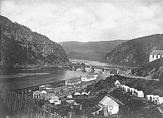
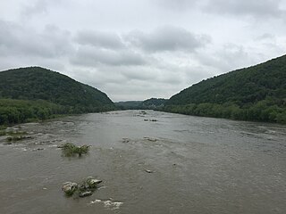
Harpers Ferry is a historic town in Jefferson County, West Virginia, United States, in the lower Shenandoah Valley. The population was 285 at the 2020 census. Situated at the confluence of the Potomac and Shenandoah rivers, where the U.S. states of Maryland, Virginia, and West Virginia meet, it is the easternmost town in West Virginia.

<span class="mw-page-title-main">Jefferson County, West Virginia</span> County in West Virginia, United States

Jefferson County is located in the Shenandoah Valley in the Eastern Panhandle of West Virginia. It is the easternmost county of the U.S. state of West Virginia. As of the 2020 census, the population was 57,701. Its county seat is Charles Town. The county was founded in 1801, and today is part of the Washington metropolitan area.

<span class="mw-page-title-main">Shenandoah Valley</span> Region of Virginia and West Virginia

The Shenandoah Valley is a geographic valley and cultural region of western Virginia and the Eastern Panhandle of West Virginia in the United States. The Valley is bounded to the east by the Blue Ridge Mountains, to the west by the eastern front of the Ridge-and-Valley Appalachians, to the north by the Potomac River, to the south by the James River, and to the Southwest by the New River Valley. The cultural region covers a larger area that includes all of the Valley plus the Virginia Highlands to the west and the Roanoke Valley to the south. It is physiographically located within the Ridge and Valley Province and is a portion of the Great Appalachian Valley.

<span class="mw-page-title-main">Battle of Harpers Ferry</span> Battle of the American Civil War

The Battle of Harpers Ferry was fought September 12–15, 1862, as part of the Maryland Campaign of the American Civil War. As Confederate Army General Robert E. Lee's Confederate army invaded Maryland, a portion of his army under Major General Thomas J. "Stonewall" Jackson surrounded, bombarded, and captured the Union garrison at Harpers Ferry, Virginia.

<span class="mw-page-title-main">U.S. Route 340</span> US Numbered Highway in Virginia, West Virginia and Maryland, United States

U.S. Route 340 is a spur route of US 40, and runs from Greenville, Virginia, to Frederick, Maryland. In Virginia, it runs north–south, parallel and east of US 11, from US 11 north of Greenville via Waynesboro, Grottoes, Elkton, Luray, Front Royal, and Berryville to the West Virginia state line. A short separate piece crosses northern Loudoun County on its way from West Virginia to Maryland.

<span class="mw-page-title-main">Storer College</span> Former American college in Harpers Ferry, West Virginia (1867–1955)

Storer College was a historically black college in Harpers Ferry, West Virginia, that operated from 1867 to 1955. A national icon for black Americans, in the town where the 'end of American slavery began', as Frederick Douglass famously put it, it was a unique institution whose focus changed several times. There is no one category of college into which it fits neatly. Sometimes white students studied alongside black students, which at the time was prohibited by law at state-regulated schools in West Virginia and the other Southern states.

<span class="mw-page-title-main">John Brown's Fort</span> Building in Harpers Ferry, West Virginia, United States

John Brown's Fort was initially built in 1848 for use as a guard and fire engine house by the federal Harpers Ferry Armory, in Harpers Ferry, Virginia. An 1848 military report described the building as "An engine and guard-house 35 1/2 x 24 feet, one story brick, covered with slate, and having copper gutters and down spouts…"

<span class="mw-page-title-main">Virginius Island, West Virginia</span>

Virginius Island is a formerly inhabited island of some 12 acres (4.9 ha), on the Shenandoah River in Harpers Ferry, West Virginia. The island was created by the Shenandoah Canal, constructed by the Patowmack Company between 1806 and 1807, which separates it from the town of Harpers Ferry. The canal was constructed to enable boats to bypass rapids on the river, and also channel water to drive machinery. In the nineteenth century Virginius Island contained Harpers Ferry's industry and working-class housing: a boarding house and row houses. Virginius Island is part of the Harpers Ferry National Historical Park.

<span class="mw-page-title-main">Jefferson Rock</span>

Jefferson Rock is a rock formation on the Appalachian Trail in Harpers Ferry, West Virginia. It consists of several large masses of Harpers shale, piled one upon the other, that overlook the Shenandoah River just prior to its confluence with the Potomac River. It was added to the National Register of Historic Places as a contributing property of the Harpers Ferry National Historical Park on October 15, 1966.

<span class="mw-page-title-main">Harpers Ferry station</span> MARC and Amtrak rail station in Harpers Ferry, West Virginia, US

Harpers Ferry station is a historic railway station in Harpers Ferry, West Virginia. It is currently served by Amtrak's Capitol Limited as well as MARC commuter service. Built by the Baltimore and Ohio Railroad, the station is part of the Harpers Ferry Historic District.

<span class="mw-page-title-main">Harpers Ferry Armory</span> Former United States federal armory

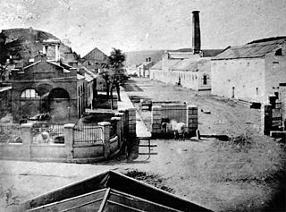
The Harpers Ferry Armory, more formally known as the United States Armory and Arsenal at Harpers Ferry, was the second federal armory created by the United States government; the first was the Springfield Armory. It was located in Harpers Ferry, Virginia, which since 1863 has been part of West Virginia. It was both an arsenal, manufacturing firearms, and an armory, a storehouse for firearms. Along with the Springfield Armory, it was instrumental in the development of machining techniques to make interchangeable parts of precisely the same dimensions.

<span class="mw-page-title-main">Loudoun Heights (mountain)</span>

Loudoun Heights, sometimes referred to as Loudoun Mountain, is the first peak of the Blue Ridge Mountain south of the Potomac River in Loudoun County, Virginia and Jefferson County, West Virginia. The northwestern slope is part of Harpers Ferry National Historical Park.

<span class="mw-page-title-main">Potomac Water Gap</span>

The Potomac Water Gap is a double water gap in the Blue Ridge Mountains, located at the intersection of the states of Virginia, West Virginia and Maryland, near Harpers Ferry. At 256 feet (78 m), it is the lowest crossing of the Blue Ridge Mountains.

<span class="mw-page-title-main">St. Peter's Roman Catholic Church (Harpers Ferry, West Virginia)</span> Historic church in West Virginia, United States

St. Peter's Roman Catholic Church in Harpers Ferry, West Virginia occupies a prominent location on the heights above Harpers Ferry. The original church was built in 1833 in a pseudo-Gothic style which it kept through the Civil War, being the only church in Harpers Ferry to escape destruction during the war. The church was extensively altered in 1896 in the then-popular Neo-Gothic style to produce the church seen today. The church commands a sweeping vista across the gorge of the Shenandoah River above its confluence with the Potomac River. The street along the side of the church building is part of the Appalachian Trail. A short trail leads from the church to Jefferson Rock. St. Peter's Church is a mission church of St. James in Charles Town. Mass is offered at the historic church every Sunday at 9:30 a.m.

<span class="mw-page-title-main">B & O Railroad Potomac River Crossing</span> United States historic place

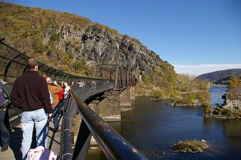
The B & O Railroad Potomac River Crossing is a 15-acre (6.1 ha) historic site where a set of railroad bridges, originally built by the Baltimore and Ohio Railroad, span the Potomac River between Sandy Hook, Maryland and Harpers Ferry, West Virginia. The site was added to the National Register of Historic Places on February 14, 1978, for its significance in commerce, engineering, industry, invention, and transportation.

<span class="mw-page-title-main">Harpers Ferry Historic District</span> Historic district in West Virginia, United States

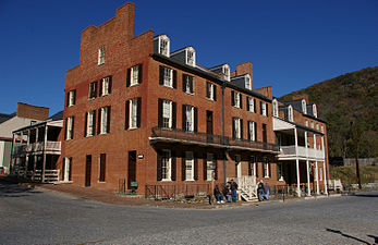
The Harpers Ferry Historic District comprises about one hundred historic structures in Harpers Ferry, West Virginia. The historic district includes the portions of the central town not included in Harpers Ferry National Historical Park, including large numbers of early 19th-century houses built by the United States Government for the workers at the Harpers Ferry Armory. Significant buildings and sites include the site of the Armory, the U.S Armory Potomac Canal, the Harpers Ferry Train Station, and Shenandoah Street, Potomac Street, and High or Washington Street. The National Historic Park essentially comprises the lower, flood-prone areas of the town, while the Historic District comprises the upper town.

The Winchester and Potomac Railroad (W&P) was a railroad in the southern United States, which ran from Winchester, Virginia, to Harpers Ferry, West Virginia, on the Potomac River, at a junction with the Baltimore and Ohio Railroad (B&O). It played a key role in early train raids of the B&O during the beginning months of the American Civil War.

<span class="mw-page-title-main">Knoxville, Maryland</span> Unincorporated community in Maryland

Knoxville is an unincorporated community in Frederick and Washington counties, Maryland, United States. The Robert Clagett Farm and Magnolia Plantation are listed on the National Register of Historic Places.

<span class="mw-page-title-main">Bolivar Heights Battlefield</span>

The Bolivar Heights Battlefield in Jefferson County, West Virginia, partly in the town of Bolivar, is an American Civil War battlefield which, – because of its strategic position overlooking Harpers Ferry, where the U.S. had an armory, and its placement at the head of the Shenandoah Valley – was the site of five separate engagements between Union and Confederate forces: in October 1861, May and September 1862, June 1863, and July 1864. The battlefield lies partly on the 669-foot (204 m) Bolivar Heights plateau, but also includes School House Ridge to the west, and the slopes of both, which meet at Bakerton Road. The site was also used by the armies as a campground, and, in 1864, as a Union corral and wagon yard.

<span class="mw-page-title-main">Lockwood House (Harpers Ferry)</span>

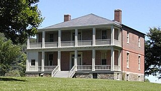
Lockwood House is a historic building in Harpers Ferry, West Virginia. One of the largest residences in Harpers Ferry, it is a massive stone and brick structure, located on the east side of Camp Hill at 360 Fillmore St., high above the town. It has a view of the town and the two rivers that meet there, the Shenandoah and the Potomac.

References

  1. "Listing of acreage – December 31, 2011" (XLSX). Land Resource Division, National Park Service. Retrieved June 16, 2012. (National Park Service Acreage Reports)
  2. "NPS Annual Recreation Visits Report". National Park Service. Retrieved August 5, 2023.
  3. "National Register Information System  (#66000041)". National Register of Historic Places . National Park Service. November 2, 2013.
  4. "John Brown". e-WV: The West Virginia Encyclopedia. December 5, 2017. Retrieved April 18, 2021.
  5. Jefferson, Thomas (1829). Notes on the State of Virginia, p. 17. Wells and Lilly, Boston.
  6. Snell, Charles W.; Mackintosh, Barry (June 1980). "National Register of Historic Places Inventory/Nomination: Harpers Ferry National Historical Park". National Park Service. With accompanying 114 photos
  7. Quigley, Aiden (April 3, 2017). "Spicer: Trump donating first-quarter salary to National Park Service". Politico . Retrieved April 3, 2017. At the start of the daily White House press briefing, Spicer handed a check for $78,333.32 to Secretary of the Interior Ryan Zinke and Tyrone Brandyburg, the superintendent of Harpers Ferry National Historical Park in West Virginia.
  8. Moyer, Teresa S.; Shackel, Paul A. (2008). The Making of Harpers Ferry National Historical Park: A Devil, Two Rivers, and a Dream. Altamira Press. ISBN   978-0759110656. OCLC   1058473018.
  9. "Storer College Site Bulletin" (PDF). NPS. Retrieved May 27, 2012.
  10. "Storer College". Harpers Ferry NHP. National Park Service. Retrieved May 27, 2012.
  11. "Harpers Ferry National Historical Park: Your Dollars At Work". National Park Service. Retrieved August 21, 2011.
  12. "Washington, DC, Facts". Washington DC Go!. Archived from the original on August 7, 2011. Retrieved August 21, 2011.
  13. American Battlefield Trust "Saved Land" webpage. Accessed May 25, 2018.

Further reading