San Juan Island National Historical Park

Last updated
San Juan Island
National Historical Park
IUCN category V (protected landscape/seascape)
San Juan Island NHP Eng Camp.JPG
British Camp
USA Washington relief location map.jpg
Red pog.svg
Usa edcp relief location map.png
Red pog.svg
Location San Juan County, Washington, USA
Nearest city Friday Harbor, Washington
Coordinates 48°27′21″N122°59′08″W / 48.45583°N 122.98556°W / 48.45583; -122.98556
Area2,141 acres (8.66 km2) [1]
AuthorizedSeptember 9, 1966 (1966-Sept-09) [2]
Visitors266,717(in 2011) [3]
Governing body National Park Service
Website San Juan Island National Historical Park
DesignatedNovember 5, 1961 [4]
DesignatedOctober 15, 1966

San Juan Island National Historical Park, also known as American and English Camps, San Juan Island, is a U.S. National Historical Park owned and operated by the National Park Service on San Juan Island in the state of Washington. The park is made up of the sites of the British and U.S. Army camps during the Pig War, a boundary dispute over the ownership of the island. The camp sites were designated a National Historic Landmark in 1961, [4] and listed on the National Register of Historic Places in 1966. The park was created by an act of Congress in 1966 and expanded slightly in 2013. [5]

Contents

Original settlement

San Juan Island is located in Puget Sound, the westernmost of the main islands of the San Juan Islands group. This island group is separated from Vancouver Island (part of British Columbia in Canada) by the Haro Strait, and from the Washington mainland by the Rosario Strait.

The islands were first settled roughly 11,000 years ago when the continental ice shelf began to recede at the end of the Last Glacial Period. [6] These original inhabitants were ancestors of six central Coast Salish tribes. [7] Archeological evidence suggests hunting and gathering on the islands between 6,000 and 8,000 years ago, and shell middens found in both English and American Camp areas indicate there were thriving villages before the arrival of Europeans. [6] Because of the harsh winter weather off the Strait of Juan de Fuca, it's likely that the American Camp area only hosted seasonal encampments for fishing and food gathering, but the sheltered bay likely made English Camp an ideal site for year-round settlement. [6] [7] An excavation by a team from the University of Washington's Burke Museum of Natural History and Culture established extensive evidence of various human uses of the area around English Camp, but was inconclusive as to whether it was a site of year round settlement. [8]

Exploration by Europeans brought smallpox to the area by the 1770s, devastating the local population. [7] The Lummi Nation, among those Coast Salish tribes whose ancestors inhabited the islands, are engaged in efforts to re-start traditional uses of the English Camp area, including reef net fishing. [6]

Territorial disputes

The Haro and Rosario straits defined the competing territorial claims of the United States and Great Britain after the Oregon Treaty of 1846 settled most of the northwestern border. [9] Both sides pursued their territorial claims, with Americans homesteading on San Juan Island, and the British Hudson's Bay Company establishing a farm on the southern tip of the island. In 1859, an American killed a stray British-owned pig, sparking the international dispute known as the Pig War. The American homesteaders requested military protection, resulting in the establishment of the American camp, while the British sent Royal Navy ships. Cooler heads prevailed, and an agreement was reached whereby both sides would maintain camps on the island until the dispute could be resolved through diplomacy. From 1860 to 1872, British Royal Marines occupied a camp on the northwestern part of the island. [10] The American garrison included Henry Martyn Robert, author of Robert's Rules of Order.

The period of military occupation was peaceful; a road was built between the two camps, and Americans in the village of San Juan engaged in commerce with both encampments. As part of the 1871 Treaty of Washington, the two countries agreed that the matter of the islands would be arbitrated by the German Kaiser Wilhelm I. The following year he declared the boundary to be the Haro Strait, thus awarding the islands to the United States. [9]

The British withdrew from their camp soon after, and the American camp was reduced in size and scope. The buildings and properties were sold as surplus or abandoned. The British camp was homesteaded in 1876 by William Crook, a farmer and carpenter, whose son built a house in the camp area in the early 20th century. The Crooks donated their property to the state beginning in the 1950s, and the state also acquired land around the American camp beginning in 1951. These properties formed the core of what became this park in 1966. [9] [10]

English Camp

The English Camp site is on Garrison Bay on the island's northwestern shore. Today the Union Jack still flies there, being raised and lowered daily by park rangers, making it one of the very few places without diplomatic status where US government employees regularly hoist the flag of another country. Surviving buildings from the British occupation include a commissary, barracks, blockhouse, and hospital; the latter building was one that was sold and moved from the site, but was later acquired by the park and returned. [10]

American Camp

The American Camp site is on the island's southernmost peninsula, and partially overlaps the original Hudson's Bay Company farm. The park property also includes the original site of San Juan village on the north shore of the peninsula, which was abandoned after the dispute ended and was entirely burned in 1890. The camp site includes three surviving buildings from the American military occupation: two officers' quarters, and the house and working quarters of the camp laundress. [9]

Recreation

The park encompasses 2,146 acres, [1] divided between two sites American Camp on the south end of San Juan Island and English Camp on northwest side of the island. Entry to both areas is free, and both include visitor centers. [11] American Camp has three mapped hiking trails, including one to the summit of Mount Finlayson. English Camp includes the Bell Point Trail, Young Hill Trail and Mitchell Hill Trail Network. [12] American Camp includes South Beach on the Strait of Juan De Fuca, with views of the Olympic Mountains, and 4 July Beach on Griffin Bay. [12] Both English and American Camps have kayak launches. [13]

Wildlife

The American Camp prairie is home to the world's only viable population of the island marble butterfly (Euchloe ausonides insulana). The butterfly was thought to be extinct for 90 years before being rediscovered in 1998, and was listed as endangered in 2020. [14] Bird species commonly spotted at American Camp include bald eagle, Harrier (bird), Harlequin duck, American goldfinch, Great horned owl and Osprey. [15] Foxes are commonly spotted, especially on the American Camp prairie, where they prey on rabbits. Orca, humpback, and gray whale can be spotted on occasion from both parks.

Related Research Articles

<span class="mw-page-title-main">Puget Sound</span> Deep water sound of the Salish Sea in northwestern Washington, United States

Puget Sound is a sound on the northwestern coast of the U.S. state of Washington. It is a complex estuarine system of interconnected marine waterways and basins. A part of the Salish Sea, Puget Sound has one major and two minor connections to the Strait of Juan de Fuca, which in turn connects to the open Pacific Ocean. The major connection is Admiralty Inlet; the minor connections are Deception Pass and the Swinomish Channel.

<span class="mw-page-title-main">San Juan Islands</span> Archipelago in the Salish Sea in Washington, US

The San Juan Islands is an archipelago in the Pacific Northwest of the United States between the U.S. state of Washington and Vancouver Island, British Columbia, Canada. The San Juan Islands are part of Washington state, and form the core of San Juan County.

<span class="mw-page-title-main">Strait of Juan de Fuca</span> Strait between Vancouver Island and the Olympic Peninsula

The Strait of Juan de Fuca is a body of water about 96 miles long that is the Salish Sea's main outlet to the Pacific Ocean. The international boundary between Canada and the United States runs down the centre of the Strait.

<span class="mw-page-title-main">San Juan County, Washington</span> County in Washington, United States

San Juan County is a county located in the Salish Sea in the far northwestern corner of the U.S. state of Washington. As of the 2020 census, its population was 17,788. The county seat and only incorporated town is Friday Harbor, located on San Juan Island. The county was formed on October 31, 1873, from Whatcom County and is named for the San Juan Islands, which are in turn named for Juan Vicente de Güemes, 2nd Count of Revillagigedo, the Viceroy of New Spain.

<span class="mw-page-title-main">Fort Vancouver</span> United States historic place

Fort Vancouver was a 19th-century fur trading post built in the winter of 1824–1825. It was the headquarters of the Hudson's Bay Company's Columbia Department, located in the Pacific Northwest. Named for Captain George Vancouver, the fort was located on the northern bank of the Columbia River in present-day Vancouver, Washington. The fort was a major center of the regional fur trading. Every year trade goods and supplies from London arrived either via ships sailing to the Pacific Ocean or overland from Hudson Bay via the York Factory Express. Supplies and trade goods were exchanged with a plethora of Indigenous cultures for fur pelts. Furs from Fort Vancouver were often shipped to the Chinese port of Guangzhou where they were traded for Chinese manufactured goods for sale in the United Kingdom. At its pinnacle, Fort Vancouver watched over 34 outposts, 24 ports, six ships, and 600 employees. Today, a full-scale replica of the fort, with internal buildings, has been constructed and is open to the public as Fort Vancouver National Historic Site.

<span class="mw-page-title-main">Oregon Treaty</span> 1846 treaty which ended the Oregon boundary dispute between the US and UK

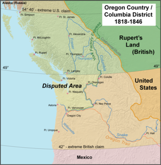
The Oregon Treaty is a treaty between the United Kingdom and the United States that was signed on June 15, 1846, in Washington, D.C. The treaty brought an end to the Oregon boundary dispute by settling competing American and British claims to the Oregon Country; the area had been jointly occupied by both Britain and the U.S. since the Treaty of 1818.

<span class="mw-page-title-main">Pig War (1859)</span> Border dispute between the United States and the United Kingdom

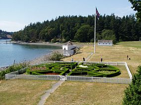
The Pig War was a confrontation in 1859 between the United States and the United Kingdom over the British–U.S. border in the San Juan Islands, between Vancouver Island and the Washington Territory. The Pig War, so called because it was triggered by the shooting of a pig, is also called the Pig Episode, the Pig and Potato War, the San Juan Boundary Dispute, and the Northwestern Boundary Dispute. Despite being referred to as a "war", there were no human casualties on either side.

<span class="mw-page-title-main">Gulf Islands National Park Reserve</span> National park reserve in British Columbia, Canada

Gulf Islands National Park Reserve is a national park located on and around the Gulf Islands in British Columbia, Canada. In the National Parks System Plan, this park provides representation of the Strait of Georgia Lowlands natural region, the only place in Canada with a Mediterranean climate of dry, sunny summers and mild, wet winters, the result of a rain shadow effect from surrounding mountains between the region and the ocean. It has similar dominant vegetation as the Pacific Northwest, such as coastal Douglas-fir, western red cedar, shore pine, Pacific dogwood, bigleaf maple, and red alder, but also contains the northern extent of some of the more drought tolerant trees such as Garry oak and Arbutus. The park was created in 2003 as the fortieth national park. It covers 36 square kilometres (14 sq mi) of area on 16 islands and more than 30 islets, reefs and surrounding waters, making it the sixth smallest national park in Canada.

<span class="mw-page-title-main">Strait of Georgia</span> Waterway between Vancouver Island and mainland North America

The Strait of Georgia or the Georgia Strait is an arm of the Salish Sea between Vancouver Island and the extreme southwestern mainland coast of British Columbia, Canada, and the extreme northwestern mainland coast of Washington, United States. It is approximately 240 kilometres (150 mi) long and varies in width from 20 to 58 kilometres. Along with the Strait of Juan de Fuca and Puget Sound, it is a constituent part of the Salish Sea.

<span class="mw-page-title-main">Lopez Island</span> Island of the San Juan Islands in Washington state, United States

Lopez Island is the third largest of the San Juan Islands and an unincorporated town in San Juan County, Washington, United States. Lopez Island is 29.81 square miles (77.2 km2) in land area. The 2020 census population was 3,156, though the population swells in the summer, as second homes, rental houses, and campsites fill up.

<span class="mw-page-title-main">San Juan Island</span> Island in the Salish Sea

San Juan Island is the second-largest and most populous of the San Juan Islands in northwestern Washington, United States. It has a land area of 142.59 km2 and a population of 8,632 as of the 2020 census.

<span class="mw-page-title-main">Orcas Island</span> Largest of the San Juan Islands, in Washington state, USA

Orcas Island is the largest of the San Juan Islands of the Pacific Northwest, in northwestern Washington, United States.

<span class="mw-page-title-main">Virgin Islands National Park</span> 14,700 acres in St. John, Virgin Islands (US) managed by the National Park Service

The Virgin Islands National Park is an American national park preserving about 60% of the land area of Saint John in the United States Virgin Islands, as well as more than 5,500 acres of adjacent ocean, and nearly all of Hassel Island, just off the Charlotte Amalie, Saint Thomas harbor.

<span class="mw-page-title-main">Golden Gate National Recreation Area</span> U.S. National Recreation Area surrounding San Francisco Bay Area

The Golden Gate National Recreation Area (GGNRA) is a U.S. National Recreation Area protecting 82,116 acres (33,231 ha) of ecologically and historically significant landscapes surrounding the San Francisco Bay Area. Much of the park is land formerly used by the United States Army. GGNRA is managed by the National Park Service and is the second-most visited unit of the National Park system in the United States, with more than 15.6 million visitors in 2022. It is also one of the largest urban parks in the world, with a size two-and-a-half times that of the consolidated city and county of San Francisco.

<span class="mw-page-title-main">Haro Strait</span> Navigable international boundary waterway connecting Juan de Fuca and Georgia Straits

The Haro Strait is one of the main channels connecting the Strait of Georgia to the Strait of Juan de Fuca, separating Vancouver Island and the Gulf Islands in British Columbia, Canada from the San Juan Islands of Washington state in the United States.

Francisco de Eliza y Reventa was a Spanish naval officer, navigator, and explorer. He is remembered mainly for his work in the Pacific Northwest. He was the commandant of the Spanish post in Nootka Sound on Vancouver Island, and led or dispatched several exploration voyages in the region, including the Strait of Juan de Fuca and the Strait of Georgia.

<span class="mw-page-title-main">José María Narváez</span>

José María Narváez was a Spanish naval officer, explorer, and navigator notable for his work in the Gulf Islands and Lower Mainland of present-day British Columbia. In 1791, as commander of the schooner Santa Saturnina, he led the first European exploration of the Strait of Georgia, including a landing on present-day British Columbia's Sunshine Coast. He also entered Burrard Inlet, the site of present-day Vancouver, British Columbia.

<span class="mw-page-title-main">Matia Island</span> Island of the San Juan islands in Washington, United States

Matia Island is an island in the San Juan Islands of the U.S. state of Washington. The island's entire 145 acres (59 ha) comes under the protection of the U.S. Fish and Wildlife Service and is cooperatively managed by the Washington State Parks and Recreation Commission as Matia Island Marine State Park. Matia Island is a National Wildlife Refuge, part of the San Juan Islands National Wildlife Refuge. A 2-acre (0.81 ha) camping area around Rolfe Cove is managed as a State Marine Park by the Washington State Parks and Recreation Commission under an agreement dating back to 1959. Pets, wood collecting, and campfires are not allowed on the island. Except for the Wilderness Loop Trail and the campground, all areas above the high tide line are closed to the public.

<span class="mw-page-title-main">Roche Harbor, Washington</span> Unincorporated community in Washington, United States

Roche Harbor is a sheltered harbor on the northwest side of San Juan Island in San Juan County, Washington, United States, and the site of a resort of the same name. Roche Harbor faces Haro Strait and the Canada–United States border. The harbor itself provides one of the better protected anchorages in the islands. The harbor is surrounded on the east side by San Juan Island, on the north side by Pearl Island, and on the west and south sides by Henry Island. Most of the harbor is 35 to 45 feet deep. Roche Harbor has a small airport used primarily by local residents.

References

  1. 1 2 "Listing of acreage – December 31, 2020" (XLSX). Land Resource Division, National Park Service. (National Park Service Acreage Reports)
  2. "Park Statistics - San Juan Island National Historical Park (U.S. National Park Service)". www.nps.gov. Retrieved 2021-05-14.
  3. "NPS Annual Recreation Visits Report". National Park Service. Retrieved 2012-03-19.
  4. 1 2 "American and English Camps, San Juan Island". National Historic Landmark summary listing. National Park Service. Archived from the original on 2008-01-30. Retrieved 2008-03-01.
  5. "Cantwell applauds new additions to San Juan Island National Historical Park". States News Service. 12 April 2013.
  6. 1 2 3 4 "The First Ones - San Juan Island National Historical Park (U.S. National Park Service)". www.nps.gov. Retrieved 2021-05-13.
  7. 1 2 3 "BLM ES GLO Record of the Week September 6 2020 StoryMap - San Juan Islands National Historical Park". ArcGIS StoryMaps. 2 September 2020. Retrieved 2021-04-30.
  8. Taylor, Amanda K (2011). Is It a House?: Archaeological Excavations at English Camp, San Juan Island, Washington. University of Washington Press. ISBN   9780295991474.
  9. 1 2 3 4 "Cultural Landscape Inventory for American Camp, San Juan National Historical Park" (PDF). National Park Service. Retrieved 2017-04-18.
  10. 1 2 3 "Cultural Landscape Inventory for British Camp, San Juan National Historical Park" (PDF). National Park Service. Retrieved 2017-04-18.
  11. "San Juan Island National Historical Park Basic Info" . Retrieved 2021-05-14.
  12. 1 2 "Hiking Trails - San Juan Island National Historical Park (U.S. National Park Service)". www.nps.gov. Retrieved 2021-05-14.
  13. "Kayak - San Juan Island National Historical Park (U.S. National Park Service)". www.nps.gov. Retrieved 2021-05-14.
  14. "Island Marble Butterfly - San Juan Island National Historical Park (U.S. National Park Service)". www.nps.gov. Retrieved 2021-04-16.
  15. "Birds - San Juan Island National Historical Park (U.S. National Park Service)". www.nps.gov. Retrieved 2021-05-14.