The Enchantments

Last updated
The Enchantments
Prusik Peak.JPG
View of Prusik Peak from Gnome Tarn
USA Washington relief location map.jpg
Red pog.svg
Floor elevation7,428 ft (2,264 m) [1]
Length5 mi (8.0 km)
Depth1,400 ft (430 m)
Geography
CountryUnited States
StateWashington
District Alpine Lakes Wilderness
Coordinates 47°28′52″N120°48′14″W / 47.48111°N 120.80389°W / 47.48111; -120.80389 [1]
Topo map USGS Enchantment Lakes

The Enchantments is a region within the Alpine Lakes Wilderness area of Washington state's Cascade Mountain Range. [2] At an elevation of 4,500 feet (1,372 m), it is home to over 700 alpine lakes and ponds surrounded by the vast peaks of Cashmere Crags, which rate among the best rock-climbing sites in the western United States. [3] The highest peak, Dragontail Peak, stretches 8,840 feet (2,694 m) high. The Enchantments is located 15 miles southwest of the popular Bavarian-themed town Leavenworth, Washington in the United States and is regarded as one of the most spectacular regions in the Cascade Range. [4]

Contents

The population increase in western Washington, specifically in the city of Seattle, marked the region a prime outdoor destination for wilderness lovers. By 2019, 100,000 visitors made their way to The Enchantments annually. [5] The influx in foot traffic and lack of maintenance from forest services and visitors had caused permanent damage to the delicate ecosystems in the region. [6] As a result, the Alpine Lakes Wilderness Society (ALPS) proposed a permit system restricting access to a maximum of 60 people at any given time. [6] In 2019, the system was approved and implemented by the Okanogan-Wenatchee National Forest (OWNF). [6] Since the implementation of the permit system, the area has been less disturbed by human activity and is expected to see significant positive impact in the near future.

History

Enchantment Basin from Prusik Pass Enchantment Basin.jpg
Enchantment Basin from Prusik Pass

Native American tribes, Yakima, Chinook and Wenatchi, traveled and thrived in and around The Enchantments region before it was ever discovered by western civilization. [7] In the early 1900s, logging and mining had consumed much of the region. [5] It was during this time that The Enchantments was named by European American, A.H. Sylvester, a topographer for the US Geological Survey in the Snoqualmie Ranger District from 1897 to 1907. [5] During his time as Wenatchee Forest district supervisor from 1908 to 1931, Sylvester had come across the unmapped alpine lakes. While exploring much of the middle basin, the upper basin was likely covered thoroughly with snow from the Snow Creek Glacier. [4] In a letter, he had described the area writing, "It was an enchanting scene. I named the group Enchantment Lakes." [3]

By the 1940s climbers reached the area and began naming the crags. Bill and Peg Stark, of Leavenworth, became frequent visitors who drew upon various mythologies to name features of the landscape. When they made their first visit in the fall of 1959, they were captivated by the golden splendor of the larch trees in the fall, the numerous lakes and tarns, and jagged peaks towering above. They used fairy names such as Gnome Tarn, Troll Sink, Naiad Lake (officially Temple Lake), Sprite and King Arthur legends in the Lower Enchantment Basin because "the lower basin was not as austere as the upper basin," according to Peg. They used Norse names and mythology for features of the upper basin, for example Lake Brynhild (officially Isolation Lake), Lake Freya (officially Tranquil Lake), and Valhalla Cirque because, Peg said, it felt "as if the Ice Age had just gone off." [8]

The official naming rulings of the US Board on Geographic Names in the 1960s resulted in a mixture of two name sets being adopted as official, particularly for the lakes, but also exemplified by the feature popularly known as Aasgard Pass being officially designated Colchuck Pass. Different sources still use the unofficial names in some contexts. The current policy of not adopting new names for geographic features in wilderness areas probably precludes the rest of the names identified by the Starks from achieving official status.

Aasgard Pass is a very steep approach to the Enchantments Colchuck Lake 2012.jpg
Aasgard Pass is a very steep approach to the Enchantments

Ecology

The elevation of The Enchantments range from 5,000 feet (1,500 m) at Nada Lake to 7,800 feet (2,400 m) in the Upper Enchantments to 8,840 feet (2,690 m) at the summit of Dragontail Peak. [9] [10] The treeline is approximately 6,400 feet (2,000 m) above Snow Lake. [9] The EPA ecoregion below the treeline is 77g, "Wenatchee/Chelan Highlands", dominated by Douglas fir, Grand fir, and Subalpine fir. Lodgepole pine, Engelmann spruce, and vine maple are also present. [11] [5] Slide alder grows in avalanche chutes. [5]

The alpine zone lies above the treeline. The climate of the alpine zone is too harsh for trees to grow, [11] but the zone is home to a number of alpine flowers: Dryas octopetala , Phacelia sericea , Saxifraga oppositifolia , Anemone drummondii , and the endemic Erigeron salishii . [12] A number of animals are permanent residents of the alpine zone: white-tailed ptarmigan, hoary marmots, and pikas. [13]

Conservation

The number of visitors to the Enchantments has exponentially increased largely due to the fast growing population in the western region of Washington state. By the late 1970s, up to 300 people would be found camping in the basin on summer weekends. The consequences of increased foot traffic compelled the Forest Service to install toilets in 1966, restrict horses in 1972, and ban dogs in 1982. By 2019, 100,000 people would visit The Enchantments annually. [6] In 1987, a permit system was implemented to prevent further destruction of the region, restricting access to only 60 campers into the region at any given time. [14] [6]

Both the rocky alpine and subalpine meadows of The Enchantments sustain highly sensitive ecosystems that battle the natural elements for nutrition and survival. [15] Concerns to preserve and protect the vegetation and habitats of the area have grown rapidly, especially in the 2000s. With over 100,000 people visiting annually as of 2019, the heavy foot traffic has violated the terms of the 1964 Wilderness Act which protects U.S. Wilderness areas, "where the earth and its community of life are untrammeled by man, where man himself is a visitor who does not remain". [16] [5]  At such high elevation, vegetation are particularly vulnerable to foot traffic due to their short growing season, sparsity and low resilience to changes in their environment. [15] Unsuccessful maintenance of The Enchantments area has also failed to address impacts such as, "degradation and loss of meadow, riparian damage, tree damage, presence of dog and human waste, widening and braiding of trails and compaction of sites and soils." [5]  To address the issue, in 2016 the ALPS proposed a permit-system that would regulate the number of visitors allowed to stay overnight in the region in order to prevent further landscape destruction. In October 2018, after much data collection, the OWNF approved the permit system effective in 2019. [6]

Mountain goat (Oreamnos americanus) in The Enchantments Basin Mountain Goat, Enchantments Basin.jpg
Mountain goat ( Oreamnos americanus ) in The Enchantments Basin

The Forest Service has banned dogs in the area, which has allowed the population of mountain goats and ptarmigan to recover. [17] [18]

In 2016, Chelan County and the Washington State Department of Ecology had proposed the Icicle Strategy plan to resolve the shortage of water supply that threatened irrigation, fish habitat and passage, and tribal and non-tribal fisheries in the Icicle Creek subbasin region. [19] The purpose of the plan was to improve stream flow and water availability into the subbasin that previously relied heavily on the tight stream of Icicle Creek.

Particularly during seasons of drought, Icicle Creek would often fail to meet minimum adopted levels. [19] In 2018, the plan was approved by the Washington State Department of Ecology. The Icicle Strategy directly impacted seven subbasin lake reservoirs in The Enchantments, optimizing, modernizing and automating the outlet works and gate infrastructures. It also restored the dam infrastructure at Eightmile Lake, also in The Enchantments, permitting higher levels of water storage. [19] Although there were concerns for flooding in and around the areas surrounding each lake and the possibility of damaging trails and vegetation, the positive impacts outweighed the risks; habitat protection, fish passage, fish screening and water conservation efficiencies. [20]

Hiking

Enchantment Lakes Topo.png
OpenTopoMap of the Enchantment Lakes

There are two primary approaches to the Enchantments Basin. Both trail heads are accessed via Icicle Creek Road. The Snow Lakes trailhead is off Icicle Creek Road at a large parking lot next to the creek. The trail climbs 6.5 miles (10.5 km) to Snow Lakes gaining 4,100 feet (1,200 m). From Snow Lakes the trail ascends over sloping granite rock to the Lower Enchantments. The entire hike is 9 miles (14 km) one-way, with 6,000 feet (1,800 m) of elevation gain to an end elevation of 7,800 feet (2,400 m). [21] This hike usually takes two days each way and is described as "long, steep, and grueling." [18] The alternate route is from the Stuart Lake trail head a couple of miles up Eightmile road off Icicle Creek Road. The trail up to Colchuck Lake is 4.75 miles (7.64 km) long and gains 2,100 feet (640 m); another 1.75 miles (2.82 km) bring hikers to the south end of the lake and Aasgard Pass, which climbs 2,200 feet (670 m) in 0.8 miles (1.3 km). [22] Aasgard Pass is a steep scramble which is dangerous to descend in snow. [23] The Aasgard Pass route has also been described as "in very bad taste" because it bypasses the beauty of the lower basin to get to the upper basin first. [22] The two routes can be combined to form a loop if the hiking party has two cars, a bicycle, or otherwise arranges transportation between the trail heads.

The United States Forest Service restricts access to the Enchantments permit area, which includes five zones. The three most popular zones are the Snow Zone (from Icicle Creek up to Snow Lakes), the Colchuck Zone (the area surrounding Colchuck Lake) and the Core Enchantment Zone (the Upper and Lower Enchantment Basins and surrounding peaks). The other zones are the Stuart Zone (the area around Stuart Lake and the northern approaches to Mount Stuart) and the Eightmile/Caroline Zone (Eightmile Lake, Eightmile Mountain, Cashmere Mountain, and vicinity). In addition, the Forest Service has proposed adding the Ingalls Lake, Headlight Basin, and Mount Stuart areas to the permit area in accordance with a 1993 NEPA decision. The earliest the change could be implemented is 2010. [2]

The Temple seen from Little Annapurna The Temple in Enchantments.jpg
The Temple seen from Little Annapurna

The 1981 Alpine Lakes Wilderness Plan established a quota of 60 people at one time as the carrying capacity of the Core Enchantment Zone. For overnight camping between May 15 and October 31 hikers in any of the five currently established zones must have permits. 75 percent of the permits for each hiking season are awarded in advance by lottery. The first round of the (very competitive) lottery includes all applications received between February 15, 2016 (12:01 a.m. PT) and March 2, 2016 (11:59 p.m. PT) for the 2016 season. All applications received during this period will be randomly drawn on or around March 6. [24] The other 25 percent of permits are issued each morning (except Sunday) at 7:45 a.m. at the Leavenworth ranger station for trips beginning the same day. If not enough permits are available for the day's applicants, the permits are awarded by lottery. [2]

Related Research Articles

<span class="mw-page-title-main">Wenatchee Mountains</span> Mountain range in Washington, United States

The Wenatchee Mountains are a range of mountains in central Washington State, United States of America. A major subrange of the Cascade Range, extending east 50 miles (80 km) from the Cascade crest, the Wenatchee Mountains separate the drainage basins of the Yakima River from the Wenatchee River. The crest of the range forms part of the boundary between Chelan and Kittitas Counties.

<span class="mw-page-title-main">Alpine Lakes Wilderness</span> Wilderness area in Washington (state)

The Alpine Lakes Wilderness is a large wilderness area spanning the Central Cascades of Washington state in the United States. The wilderness is located in parts of Wenatchee National Forest and Snoqualmie National Forest, and is approximately bounded by Interstate 90 and Snoqualmie Pass to the south and U.S. Route 2 and Stevens Pass to the north. The Alpine Lakes is the largest wilderness area near the population centers of Puget Sound, counted at 414,161 acres (167,605 ha) following the 2014 expansion.

<span class="mw-page-title-main">Dragontail Peak</span> Mountain in Washington (state), United States

Dragontail Peak, also known as Dragon Tail, is a mountain in the Stuart Range, in Chelan County, Washington. While climbing an adjacent peak, Lex Maxwell, Bob McCall, and Bill Prater remarked that the needles on the crest, southwest of the summit, resembled a "dragon tail". The name was officially accepted in 1955. On the mountain's northeast flank lies Colchuck Lake which drains into Mountaineer Creek, and Colchuck Glacier lies below the western slopes of the peak. On its south side the mountain drops steeply to Ingalls Creek, which flows about 5,800 feet (1,800 m) below the summit.

<span class="mw-page-title-main">Icicle Creek</span> River in Washington, United States

Icicle Creek is a non navigable stream in the U.S. state of Washington. It originates at Josephine Lake near the crest of the Cascade Range and flows generally east to join the Wenatchee River near Leavenworth. Icicle Creek's drainage basin is mountainous and mostly undeveloped land within the Wenatchee National Forest and the Alpine Lakes Wilderness. The final 6 miles (10 km) of the creek are moderately developed with scattered homes and pasture, a golf course, children's camp, a small housing development called Icicle Island Club, and the Leavenworth National Fish Hatchery. Some water is diverted from the creek for municipal use by the City of Leavenworth at Icicle Creek river mile 5.6. Near Leavenworth, the wheelchair-accessible Icicle Creek Nature Trail, a National Recreation Trail designated in 2005, runs 1.0 mile (1.6 km) along a historic creek channel.

<span class="mw-page-title-main">Aasgard Pass</span>

Aasgard Pass, officially identified as Colchuck Pass, is a mountain pass on the east side of the Cascades in Washington's Alpine Lakes Wilderness southwest of Leavenworth. It is the shorter and steeper of two primary hiking routes into the Enchantments, one of Washington's most popular hiking areas. It separates Colchuck Lake to the northwest from the Upper Enchantment Basin to the southeast. Aasgard Pass is located at the saddle between Dragontail Peak and the Enchantment Peaks.

<span class="mw-page-title-main">Enchantment Peak</span> Mountain in Washington (state), United States

Enchantment Peak is an 8,520+ ft granite summit located in Chelan County of Washington state. Enchantment Peak is part of The Enchantments within the Alpine Lakes Wilderness. Enchantment Peak belongs to the Stuart Range which is subset of the Cascade Range. Enchantment Peak is situated midway between Prusik Peak to its east, and Aasgard Pass and Dragontail Peak to the west. Precipitation runoff drains into Icicle Creek, a tributary of the Wenatchee River.

<span class="mw-page-title-main">Jabberwocky Tower</span>

Jabberwocky Tower is a 6,840-foot-elevation granite spire located in Chelan County of Washington state. Jabberwocky Tower is part of The Enchantments within the Alpine Lakes Wilderness. It belongs to the Stuart Range which is subset of the Cascade Range. Jabberwocky Tower is situated east of Colchuck Lake and west of Enchantment Peak. Precipitation runoff drains into Icicle Creek, a tributary of the Wenatchee River.

<span class="mw-page-title-main">Colchuck Peak</span> Mountain in Washington (state), United States

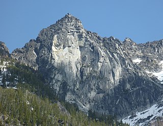
Colchuck Peak is an 8,705-foot (2,653-metre) mountain summit located in the Stuart Range, in the Alpine Lakes Wilderness in Chelan County of Washington state. The nearest higher peak is Dragontail Peak, 0.49 mi (0.79 km) to the east, and Argonaut Peak lies 0.9 mi (1.4 km) to the southwest. The Colchuck Glacier which lies on the northeast slopes of the peak melts into Colchuck Lake. The mountain and glacier take their name from the lake, which in Chinook jargon means "cold water". Precipitation runoff from the peak drains north into Mountaineer Creek, a tributary of Icicle Creek, or south into Ingalls Creek, all of which winds up in the Wenatchee River. Colchuck Peak is more notable for its steep rise above local terrain than for its absolute elevation as topographic relief is significant with the summit rising 3,130 feet (954 m) above Colchuck Lake in 1 mi (1.6 km), and 4,600 feet (1,402 m) above Ingalls Creek in 1.9 mi (3.1 km).

<span class="mw-page-title-main">Colchuck Balanced Rock</span>

Colchuck Balanced Rock is an 8,200+ ft granite mountain summit located in Chelan County of Washington state. Colchuck Balanced Rock is part of The Enchantments within the Alpine Lakes Wilderness. It belongs to the Stuart Range which is subset of the Cascade Range. Colchuck Balanced Rock is situated west of Enchantment Peak, and east of Jabberwocky Tower and Colchuck Lake. Precipitation runoff from the peak drains into the lake and Mountaineer Creek, a tributary of Icicle Creek. The climbing approach is via the Colchuck Lake Trail, then traversing away from Aasgard Pass approximately 400 feet above the lake. The mountain is named for its pyramidal summit which has a top-block that nests, rather than balances, on the summit. The mountain and glacier take their name from the lake, which in Chinook jargon means "cold water".

<span class="mw-page-title-main">Eightmile Mountain</span> Mountain in Washington (state), United States

Eightmile Mountain is a 7,996-foot (2,437-metre) mountain summit located in Chelan County of Washington state. Eightmile Mountain is situated within the Alpine Lakes Wilderness, on land managed by the Okanogan–Wenatchee National Forest. It is part of the Wenatchee Mountains which are a subset of the Cascade Range. Its nearest higher neighbor is Cashmere Mountain, 3 mi (4.8 km) to the northeast, and Mount Stuart rises 4 mi (6.4 km) to the south. Precipitation runoff from the mountain drains into Trout Creek and Eightmile Creek, both tributaries of Icicle Creek, which in turn is a tributary of the Wenatchee River. This mountain is known for its spring skiing and excellent view of the Stuart Range.

<span class="mw-page-title-main">Witches Tower (Washington)</span> Mountain in Washington (state), United States

Witches Tower is an 8,520+ ft granite summit located 10 mi (16 km) southwest of Leavenworth in Chelan County of Washington state. Witches Tower is part of The Enchantments within the Alpine Lakes Wilderness, and is set on land managed by the Okanogan–Wenatchee National Forest. It belongs to the Stuart Range which is subset of the Wenatchee Mountains. Witches Tower is situated 0.8 mi (1.3 km) northwest of Little Annapurna, and 0.4 mi (0.64 km) east-southeast of Dragontail Peak, which is its nearest higher neighbor. Witches Tower is surrounded by remnants of Snow Creek Glacier. Precipitation runoff drains into tributaries of the Wenatchee River.

<span class="mw-page-title-main">Eightmile Lake</span>

Eightmile Lake is a reservoir lake located on the eastern slope of Eightmile Mountain, in Chelan County in Washington. It is a reservoir lake formed along the beginning route of Eightmile Creek as it exits Jack Ridge.

<span class="mw-page-title-main">Colchuck Lake</span> Lake in Washington, United States

Colchuck Lake is a freshwater reservoir lake located on the western slope of The Enchantments, in Chelan County, Washington. The lake is located approximately 15 miles from the city of Leavenworth, Washington and sits on the southeast corner of the Icicle Creek subbasin. It is accessed by a 4-mile trail that starts at USFS Road 7601 as it crosses over Eightmile Creek and makes a turn towards the Stuart and Culchuck Lake Trailhead where the road ends. The origin of the word comes from Chinook Jargon kol + cak to mean cold waters.

Klonaqua Lakes are a set of freshwater reservoir lakes located on the western slope of The Enchantments, in Chelan County, Washington. Self-issued Alpine Lake Wilderness permit required for transit within the Klonaqua Lakes area.

<span class="mw-page-title-main">Snow Lakes</span> System of freshwater lakes in Chelan County, Washington

Snow Lakes are a system of freshwater reservoir lakes made by Upper Snow Lake and Lower Snow Lake, approximately a mile long. They are located on the eastern slope of The Enchantments, in Chelan County, Washington. The Snow Lakes are one of the most heavily used destination in the Forest Service wildernesses in Oregon and Washington. Self-issued Alpine Lakes Wilderness permits are required for transit within the Snow Lakes area.

Nada Lake is a freshwater reservoir lakes located on the eastern slope of The Enchantments, in Chelan County, Washington. Self-issued Alpine Lakes Wilderness permits are required for transit within the Snow Lakes area.

Lake Augusta is a freshwater lake located on the southwest skirt of Big Jim Mountain, East of Icicle Ridge, in Chelan County, Washington. Because of its close proximity to Icicle Ridge Trail, the lake is a popular area for hiking, swimming, and fishing cutthroat trout. Smaller Lake Ida is a short distance on the opposite side of Icicle Ridge and Big Jim Mountain Lakes or on the northeast slope of the mountain. Lake Augusta is located approximately 15 miles west of the city of Leavenworth. Self-issued Alpine Lake Wilderness permit required for transit within the Lake Augusta area.

Lake Ida is a freshwater lake located along Icicle Ridge, approximately 10 miles west of the city of Leavenworth in Chelan County, Washington. Because of its close proximity to Icicle Ridge Trail, the lake is a popular area for hiking, swimming, and fishing cutthroat trout. Lake Augusta is a short distance on the opposite side of Icicle Ridge. Lake Ida sits on a highly glaciated alpine cirque, surrounded by a coniferous forest primarily larch pines and outflows into Ida Creek, a tributary of Icicle Creek. At least one unrated waterfall is found downstream as Ida Creek runs the south slope of Icicle Ridge. Self-issued Alpine Lake Wilderness permit required for transit within the Lake Ida and Augusta area.

<span class="mw-page-title-main">Lake Edna</span> Lake in Washington state, US

Lake Edna is a freshwater lake located along Icicle Ridge, approximately 10 miles west of the city of Leavenworth in Chelan County, Washington. Because of its close proximity to Icicle Ridge Trail, the lake is a popular area for hiking, swimming, and fishing. Lake Alice is a short distance in a prominent cirque on the opposite side of Icicle Ridge.

<span class="mw-page-title-main">Wedge Mountain (Washington)</span> Mountain in Washington (state), United States

Wedge Mountain is a 5,860-foot-elevation (1,786-meter) summit located in Chelan County of Washington state. It is set on the boundary line of the Alpine Lakes Wilderness, on land managed by Okanogan-Wenatchee National Forest. Wedge Mountain is the northeastern terminus of the Stuart Range, which is a subset of the Cascade Range. It is situated 3.5 miles (5.6 km) northeast of The Temple, and the nearest town is Leavenworth, 5 miles (8.0 km) to the north-northeast. Precipitation runoff from the mountain drains into tributaries of the Wenatchee River. Topographic relief is significant as the summit rises over 2,800 feet above Snow Creek in one-half mile. Backpackers hiking en route to The Enchantments via the Snow Creek Trail traverse the western foot of this mountain. Wedge Mountain is the toponym officially adopted by the U.S. Board on Geographic Names for the 5,860-foot summit.

References

  1. 1 2 "Enchantment Basin". Geographic Names Information System . United States Geological Survey, United States Department of the Interior.
  2. 1 2 3 "Enchantment Area Wilderness Permits". US Forest Service. 2009. Archived from the original on 2007-03-29. Retrieved 2009-10-05.
  3. 1 2 "Enchantments : Climbing, Hiking & Mountaineering : SummitPost". www.summitpost.org. Retrieved 2020-11-06.
  4. 1 2 Marler, Chester (2004). East of the Divide: Travels through the Eastern Slope of the North Cascades 1870-1999. North Fork Books. p. 50. ISBN   0975460501.
  5. 1 2 3 4 5 6 7 "Alpine Lakes Wilderness". www.historylink.org. Retrieved 2020-11-06.
  6. 1 2 3 4 5 6 Alpine Lakes Protection Society (February 2019). "USFS action regarding Enchantments overuse" (PDF). Alpine Lakes Protection Society. Retrieved October 16, 2020.
  7. "Leavenworth History | City of Leavenworth, WA" . Retrieved 2020-11-06.
  8. Sykes, Karen (October 8, 1998). "World-renowned basin in the Alpine Lakes Wilderness has a magical allure". Special to the Post-Intelligencer. Seattle Post-Intelligencer . Retrieved 2007-08-09.[ dead link ] Alt URL
  9. 1 2 Enchantment Permit Area Zones (PDF) (Map). US Forest Service.
  10. "Dragontail Peak, Washington". Peakbagger.com.
  11. 1 2 "Ecoregions of Western Washington and Oregon" (PDF). US EPA. Retrieved 2022-08-07.
  12. "North Cascades". Alpine flora of Washington State. Retrieved 2022-08-07.
  13. Johnson, D.H.; O’Neil, T.A. (2001). Wildlife Habitat Relationships Washington and Oregon. Oregon State University Press. ISBN   0-87071-488-0.
  14. Foster, David (September 7, 1989). "Rangers help control overcrowding as hikers try loving forests to death". The Bulletin (Bend) . Retrieved 2014-09-19.
  15. 1 2 Hunter, Rebecca (2018-05-08). "Places of the Pacific: The Enchantments". Wildlands Network. Retrieved 2020-10-17.
  16. 88th Congress (September 3, 1964). "Wilderness Act" (PDF). U.S. Forest Service . Retrieved October 16, 2020.
  17. Johnston, Greg (October 21, 2004). "A heavenly reward awaits in the Enchantment Lakes Basin". Seattle Post-Intelligencer . Retrieved 2007-08-09.
  18. 1 2 Spring, Ira; Manning, Harvey (1998). 100 Classic Hikes in Washington's Alpine Lakes (1st ed.). The Mountaineers. ISBN   0-89886-707-X.
  19. 1 2 3 "Icicle Creek strategy - Washington State Department of Ecology". ecology.wa.gov. Retrieved 2020-10-17.
  20. "Chelan County Natural Resources - Environmental Review". www.co.chelan.wa.us. Retrieved 2020-10-17.
  21. "Enchantment Lakes". Washington Trails Association.
  22. 1 2 Spring, Ira; Spring, Vicky; Manning, Harvey (2002). 100 Classic Hikes in Washington (3rd ed.). The Mountaineers. ISBN   0-89886-586-7.
  23. Nelson, Jim; Potterfield, Peter (2003). Selected Climbs in the Cascades. Vol. 1 (2nd ed.). Mountaineers Books. p. 114.
  24. "Enchantment Permit Area, WA". Recreation.gov. Retrieved 2015-09-25.