Mineral County, West Virginia

Last updated

Mineral County
MineralCountyCourthouse2012.jpg
Seal of Mineral County, West Virginia.png
Map of West Virginia highlighting Mineral County.svg
Location within the U.S. state of West Virginia
West Virginia in United States.svg
West Virginia's location within the U.S.
Coordinates: 39°25′N78°56′W / 39.42°N 78.94°W / 39.42; -78.94
CountryFlag of the United States.svg United States
StateFlag of West Virginia.svg  West Virginia
FoundedFebruary 1, 1866
Seat Keyser
Largest cityKeyser
Area
  Total329 sq mi (850 km2)
  Land328 sq mi (850 km2)
  Water1.4 sq mi (4 km2)  0.4%
Population
 (2020)
  Total26,938
  Estimate 
(2021)
26,857 Decrease2.svg
  Density82/sq mi (32/km2)
Time zone UTC−5 (Eastern)
  Summer (DST) UTC−4 (EDT)
Congressional district 1st
Website www.mineralwv.org

Mineral County is a county in the U.S. state of West Virginia. It is part of the Cumberland metropolitan area, together with Cumberland, Maryland. As of the 2020 census, the population was 26,938. [1] Its county seat is Keyser. [2] The county was founded in 1866. [3]

Contents

History

Ancient history

Indigenous peoples lived throughout the highlands along rivers in this area for thousands of years. Archeologists have identified artifacts of the Adena culture, dating from 1000 BC to 200 BC. They were among the several early Native American cultures who built major earthwork mounds for ceremonial and burial use. Remnants of their culture have been found throughout West Virginia. They were followed by other indigenous peoples.

With the growth of fur trading to the north after European encounter in the coastal areas, the nations of the Haudenosaunee (or Iroquois Confederacy), based in present-day New York, moved into the Ohio Valley in search of new hunting grounds. By the 17th century they had conquered other tribes, pushed them out to the west, and preserved the area for hunting.

1863 to present

It was not until after West Virginia became a state in 1863 that present-day Mineral County was organized. It was created in 1866 by an Act of the West Virginia Legislature from the existing Hampshire County. The name was selected due to its reserves of minerals, especially coal - although coal, a type of sedimentary rock, is not a mineral because it does not have a crystalline structure.

The seminal point in the creation of the county was the arrival of the main line of the Baltimore and Ohio Railroad in 1842. The county seat of Keyser was named for an executive of the railroad. [4]

In 1863, West Virginia's counties were divided into civil townships, with the intention of encouraging local government. This proved impractical in the heavily rural state, and in 1872 the townships were converted into magisterial districts. [5] After its formation in 1866, Mineral County was divided into seven townships: Cabin Run, Elk, [lower-roman 1] Frankfort, Mill Creek, New Creek, Piedmont, and Welton. Mill Creek Township was returned to Hampshire County in 1871, and in 1872 the six remaining townships became magisterial districts. Except for minor adjustments, they remained relatively unchanged until the 1980s, when they were consolidated into three new districts: District 1, District 2, and District 3. [6]

Geography

According to the United States Census Bureau, the county has a total area of 329 square miles (850 km2), of which 328 square miles (850 km2) is land and 1.4 square miles (3.6 km2) (0.4%) is water. [7]

Mountains

The northern terminus of the Allegheny Front in West Virginia lies in Mineral County and includes the highest point in the county. Known as "the Pinnacle", it is 3,104 feet (946 m) above sea level. From the abandoned fire tower four states are visible, Pennsylvania, Maryland, West Virginia, and Virginia. The Allegheny Front is the largest mountain in the county; on the north end it is also known as Green Mountain. On top of the Allegheny Plateau is located the town of Elk Garden, West Virginia in the southwestern portion of the county. The Potomac River Valley lies to west and north of the mountain, and the New Creek Valley lies to the east.

Knobly Mountain lies between the New Creek and Patterson Creek valleys. It is the longest mountain in Mineral County stretching from the Grant County line in the south to the Potomac River in the north at Ridgeley, West Virginia.

To the east of the Patterson Creek Valley lie a series of low hills which form the eastern border of the county with Hampshire County.

Rivers

Minerals

Natural gas is found east of the Allegheny Front as well as iron ore deposits. The county no longer produces iron, but several abandoned iron furnaces from the 19th century still exist.

Demographics

Historical population
CensusPop.Note
1870 6,332
1880 8,63036.3%
1890 12,08540.0%
1900 12,8836.6%
1910 16,67429.4%
1920 19,84919.0%
1930 20,0841.2%
1940 22,21510.6%
1950 22,3330.5%
1960 22,3540.1%
1970 23,1093.4%
1980 27,23417.9%
1990 26,697−2.0%
2000 27,0781.4%
2010 28,2124.2%
2020 26,938−4.5%
2021 (est.)26,857 [9] −0.3%
U.S. Decennial Census [10]
1790–1960 [11] 1900–1990 [12]
1990–2000 [13] 2010–2020 [1]

2020 census

As of the 2020 census, there were 26,938 people and 10,431 households residing in the county. There were 12,453 housing units in Preston. The racial makeup of the county was 91.9% White, 2.7% African American, 0.4% Asian, 0.2% Native American, 0.4% from other races, and 4.5% from two or more races. Hispanics or Latinos of any race were 1.15% of the population.

Of the 12,510 households, 50.2% were married couples living together, 27.6% had a female householder with no spouse present, 16.1% had a male householder with no spouse present. The average household and family size was 3.19. The median age in the county was 44.6 years with 20.2% of the population under 18. The median income for a household was $57,345 and the poverty rate was 12.1%. [14]

2010 census

At the 2010 census, there were 28,212 people, 11,550 households, and 7,879 families residing in the county. [15] The population density was 86.1 inhabitants per square mile (33.2/km2). There were 13,039 housing units at an average density of 39.8 units per square mile (15.4 units/km2). [16] The racial makeup of the county was 95.3% white, 2.8% black or African American, 0.4% Asian, 0.1% American Indian, 0.1% from other races, and 1.2% from two or more races. Those of Hispanic or Latino origin made up 0.7% of the population. [15] In terms of ancestry, 32.9% were German, 16.0% were Irish, 11.3% were English, and 10.0% were American. [17]

Of the 11,550 households, 28.5% had children under the age of 18 living with them, 53.5% were married couples living together, 10.0% had a female householder with no husband present, 31.8% were non-families, and 27.0% of all households were made up of individuals. The average household size was 2.39 and the average family size was 2.87. The median age was 42.3 years. [15]

The median income for a household in the county was $36,571 and the median income for a family was $46,820. Males had a median income of $44,068 versus $25,675 for females. The per capita income for the county was $20,805. About 11.7% of families and 16.1% of the population were below the poverty line, including 25.2% of those under age 18 and 12.7% of those age 65 or over. [18]

2000 census

At the 2000 census, there were 27,078 people, 10,784 households, and 7,710 families residing in the county. The population density was 83 people per square mile (32 people/km2). There were 12,094 housing units at an average density of 37 units per square mile (14 units/km2). The racial makeup of the county was 96.16% White, 2.55% Black or African American, 0.11% Native American, 0.20% Asian, 0.01% Pacific Islander, 0.21% from other races, and 0.76% from two or more races. 0.58% of the population were Hispanic or Latino of any race.

There were 10,784 households, out of which 30.40% had children under the age of 18 living with them, 57.90% were married couples living together, 9.70% had a female householder with no husband present, and 28.50% were non-families. 25.00% of all households were made up of individuals, and 11.50% had someone living alone who was 65 years of age or older. The average household size was 2.46 and the average family size was 2.93.

In the county, the population was spread out, with 23.40% under the age of 18, 8.60% from 18 to 24, 27.10% from 25 to 44, 25.90% from 45 to 64, and 15.10% who were 65 years of age or older. The median age was 39 years. For every 100 females there were 95.80 males. For every 100 females age 18 and over, there were 93.00 males.

The median income for a household in the county was $31,149, and the median income for a family was $37,866. Males had a median income of $32,337 versus $20,090 for females. The per capita income for the county was $15,384. About 11.50% of families and 14.70% of the population were below the poverty line, including 21.10% of those under age 18 and 11.60% of those age 65 or over.

Politics

After having leaned strongly towards the Democratic Party between the New Deal and Bill Clinton's presidency, most of West Virginia has, since 2000, seen a swing towards the Republican Party due to declining unionization [19] and differences with the Democratic Party's liberal views on social issues. [20] Mineral County, in contrast, was formed from the Unionist portion of Hampshire County following the Civil War and has always leaned Republican, although it has never been nearly so rock-ribbed as analogously created Grant County. Nonetheless, Mineral County would not vote Democratic between 1888 and 1932 inclusive – although voting for Theodore Roosevelt in 1912 [21] – and the last Democrat to carry the county was Jimmy Carter in 1976.

United States presidential election results for Mineral County, West Virginia [22]
Year Republican Democratic Third party
No.%No.%No.%
2020 10,04077.97%2,66020.66%1761.37%
2016 9,07077.71%2,05017.56%5514.72%
2012 7,83371.29%2,88526.26%2702.46%
2008 7,61665.96%3,75032.48%1811.57%
2004 7,85468.53%3,51830.70%890.78%
2000 6,18063.18%3,34134.15%2612.67%
1996 4,38048.26%3,48738.42%1,20913.32%
1992 4,83745.09%3,99237.21%1,89917.70%
1988 6,01559.49%4,05940.14%370.37%
1984 7,29165.46%3,83234.40%150.13%
1980 6,12554.33%4,67141.43%4784.24%
1976 5,13046.52%5,89853.48%00.00%
1972 7,15768.60%3,27631.40%00.00%
1968 4,54545.26%4,22542.07%1,27312.68%
1964 3,80137.47%6,34462.53%00.00%
1960 6,29960.20%4,16439.80%00.00%
1956 6,41264.12%3,58835.88%00.00%
1952 5,59855.19%4,54544.81%00.00%
1948 4,38248.71%4,58650.98%280.31%
1944 4,63553.75%3,98946.25%00.00%
1940 5,13349.70%5,19550.30%00.00%
1936 4,48645.50%5,33354.09%400.41%
1932 4,51950.95%4,09846.21%2522.84%
1928 5,86071.36%2,31028.13%420.51%
1924 3,55149.62%2,86039.96%74610.42%
1920 3,64657.90%2,51639.96%1352.14%
1916 1,96551.83%1,74746.08%792.08%
1912 51314.69%1,36739.16%1,61146.15%

Government

County Commission

Mineral County is governed by a three-member commission, one member to be elected every two years to a six-year term of office. The County Commission, as the governing body, is responsible for the fiscal affairs and general administration of county government. The County Commission does not possess home rule per Article 6, Section 39a of the Constitution of West Virginia. [23]

Commissioners

  • Jerry Whisner, Republican Commission President
  • Roger Leatherman, Republican: term ending 2020
  • Charles "Dutch" Staggs

Appointed commissions

  • The Mineral County Planning Commission is charged with administering Mineral County's land use ordinances. It operates under section §8A-2-1 of the West Virginia state code. [24] Its subdivisions include Industrial Park Construction, Storm Water Management, and Flood Plain Management. Members are appointed to the planning commission, by the county commission, for 3 year terms.
  • The Mineral County Development Authority administers industrial parks and seeks to bring new business to the county. Current executive director, Kevin Clark

Office of Assessor

Circuit Clerk

•Krista Dixon

County Clerk

The Clerk is elected to a six-year term with the right to succeed himself/herself. The primary duties and responsibilities of the Clerk of the County Commission may be identified as two basic functions:

  1. to act as clerk (fiscal officer, secretary) of the County Commission, and
  2. to act as the receiver of fees charged for the instruments to be filed and recorded within the county. The official books and papers of the Office of the Clerk of the County Commission are considered permanent public records.

The County Commissions through their clerks shall have the custody of all deeds and other papers presented for record in their counties and they shall be preserved therein. They shall have jurisdiction in all matters of probate, the appointment and qualification of personal representatives, guardians, committees, curators and the settlement of their accounts. The Clerk shall have custody of all election records, payroll and budgetary accounting, and accounts payable. [25]

County Clerk: Lauren Ellifritz, Republican

State representatives

House of Delegates

DistrictRepresentativePartyCounty/Counties
87 Gary G. Howell Republican Mineral (part)
88 Rick Hillenbrand Republican Mineral (part), Hampshire (part)

Senate

DistrictSenatorPartyCounty/Counties
14 Jay Taylor Republican Barbour, Grant (part), Mineral, (part)
Monongalia (part), Preston, Hardy, Taylor, Tucker
Randy Smith Republican
15 Craig Blair Republican Berkeley (part), Hampshire, Mineral, (part)
Morgan
Charles Trump Republican

Economy

Industrial parks

The Mineral County Development Authority operates industrial parks near Keyser, featuring rail access, and near Fort Ashby, with fiber optics and sitewide wireless Internet Keyser Industrial Park Fort Ashby Business and Technology Park

Education

The school district for Mineral County is Mineral County Schools.

High schools

Mineral County Schools includes two high schools: Frankfort High School located near Short Gap and Keyser High School located south of Keyser.

Colleges

Potomac State College, a two-year school, is located in the county seat of Keyser, West Virginia on the site of Civil War Fort Fuller.

Transportation

Airport

The Greater Cumberland Regional Airport is located in Wiley Ford.

Public transportation

The Potomac Valley Transit Authority provides deviated fixed route and demand response public transportation services to residents.

Rail

CSX lines run along the Potomac River on the northern border of the county. Amtrak service is available in Cumberland, Maryland, just across from Ridgeley, West Virginia. Keyser's railroad station closed in the 1980s.

Major highways

Parks and public recreational attractions

Larenim Park

Owned by Mineral County, the park size is 365 acres (1.48 km2). Includes two pavilions with 10 tables, an amphitheater with seating capacity of 600. One Little League field and one softball field. Fishing Areas; two flood control dams stocked by WVDNR, 5 and 2.5 acres (20,000 and 10,000 m2). All 365 acres (1.48 km2) are open to public hunting by permit. Approximately 5 miles of trails. An arboretum is under construction at Larenim to include a Shale Barrens Conservancy. Larenim Park is also home to the local theater group, McNeill's Rangers. [26] [27]

Barnum Whitewater Area

Owned by Mineral County with size of approximately 40 acres (160,000 m2). Includes four miles (6.4 km) of rail/trail. This area has approximately 1-mile (1.6 km) of river frontage on the North Branch of the Potomac River below Jennings Randolph Lake, along the old Western Maryland Railway right-of-way. It is one of the best trout streams in West Virginia and also provides seven miles (11 km) of whitewater rafting and canoeing for the entire family to enjoy. Public hunting permitted on surrounding state lands.

MINCO Park

Owned by Mineral County Schools, MINCO Park's size is 13.5 acres (55,000 m2). Its facilities include two pavilions with 50 picnic tables, nine cabins, a dining field, a chapel, meeting room, and bath/shower facilities.

Van Myra Campground

Owned by the State of West Virginia and leased by Mineral County, the campground area is 10 acres (40,000 m2). Three picnic tables, four mini-pavilions, and picnic area only comprise this facility.

Dam Site #21

Owned by Mineral County, 178 acres (0.72 km2), with no facilities. Fishing 10 acres (40,000 m2) flood control dam.

Jennings Randolph Lake

Jennings Randolph Lake, named for Senator Jennings Randolph. The lake was originally named Bloomington Lake. The lake was constructed in 1981 on top of the town of Shaw, West Virginia by the United States Army Corps of Engineers. The lake is located near Elk Garden. The lake offers extensive recreational opportunity with its 952 acres (3.85 km2) and more than 13 miles (21 km) of shoreline. Howell Run Picnic Area overlooks the lake and contains 40 picnic sites, two pavilions, a playground and vault toilets. The Howell Run Boat Launch consists of a two lane concrete ramp. the Robert W. Craig Campground is situated on a high ridge overlooking the dam site and features 87 campsites, potable water, hot showers, vault toilets and a playground. A 3/4 mile long interpretive trail has been developed in the area. The West Virginia Overlook area contains a two tier Visitor Center. Waffle Rock, a unique natural rock formation, can also be viewed from the Overlook.

Golf courses

Libraries

Mineral County is home to the Keyser-Mineral County public library. It was a product of the Works Progress Administration and opened in 1937. In 1962 in moved to a larger location, in the building formerly occupied by the Farmers and Merchants bank. The library is funded by the West Virginia Library Commission, Mineral County Court, and Keyser City Council. In addition to the main branch in Keyser, the library also has branches in Burlington and Fort Ashby. [28]

There is also the Piedmont Public Library that is a County United Way agency. The library is funded by County United Way and West Virginia Library Commission. [29]

Communities

City

Towns

Magisterial districts

Census-designated places

Unincorporated communities

Historical sites

Saddle Mountain as viewed from Highland Acres Farm Saddle-mtn.jpg
Saddle Mountain as viewed from Highland Acres Farm

Notable people

See also

Footnotes

  1. Also called "Elk Garden" in early records.

Related Research Articles

<span class="mw-page-title-main">Garrett County, Maryland</span> County in Maryland, United States

Garrett County is the westernmost county of the U.S. state of Maryland completely within the Appalachian Mountains. As of the 2020 census, the population was 28,806, making it the third-least populous county in Maryland. Its county seat is Oakland. The county was named for John Work Garrett (1820–1884), president of the Baltimore and Ohio Railroad. Created from Allegany County in 1872, it was the last county to be formed in the state.

<span class="mw-page-title-main">Morgan County, West Virginia</span> County in West Virginia, United States

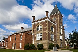
Morgan County is a county located in the U.S. state of West Virginia. As of the 2020 census, the population was 17,063. Its county seat is Berkeley Springs. The county was formed in 1820 from parts of Hampshire and Berkeley Counties and named in honor of General Daniel Morgan, prominent soldier of the American Revolutionary War. The county and town of Bath are considered an excellent jumping off point for exploring the Potomac and Cacapon Rivers valleys just to the north and west. Along with also being a tourist destination hosting numerous local artists, mineral water spas, and a large amount of outdoor recreation that includes fishing, boating, wildlife, hunting, and mountain scenery. The region is known for the famed Apple Butter Festival held annually in October. Morgan County is also the home of an important silica mine, part of U.S. Silica.

<span class="mw-page-title-main">Hardy County, West Virginia</span> County in West Virginia, United States

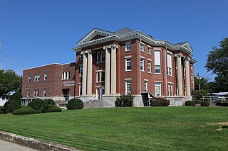
Hardy County is a county in the U.S. state of West Virginia. As of the 2020 census, the population was 14,299. Its county seat is Moorefield. The county was created from Hampshire County in 1786 and named for Samuel Hardy, a distinguished Virginian.

<span class="mw-page-title-main">Hampshire County, West Virginia</span> County in West Virginia, United States

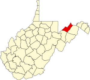
Hampshire County is a county in the U.S. state of West Virginia. As of the 2020 census, the population was 23,093. Its county seat is Romney, West Virginia's oldest town (1762). The county was created by the Virginia General Assembly in 1754, from parts of Frederick and Augusta Counties (Virginia) and is the state's oldest county. The county lies in both West Virginia's Eastern Panhandle and Potomac Highlands regions.

<span class="mw-page-title-main">Grant County, West Virginia</span> County in West Virginia, United States

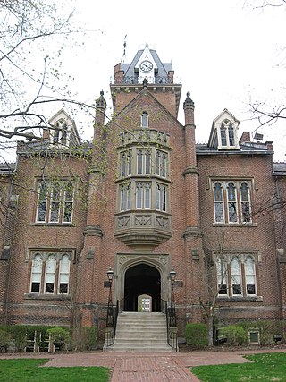
Grant County is a county in the U.S. state of West Virginia. As of the 2020 census, the population was 10,976. Its county seat is Petersburg. The county was created from Hardy County in 1866 and named for Civil War General and the 18th president of the United States Ulysses S. Grant.

<span class="mw-page-title-main">Brooke County, West Virginia</span> County in West Virginia, United States

Brooke County is a county in the Northern Panhandle of the U.S. state of West Virginia. As of the 2020 census, the population was 22,559. Its county seat is Wellsburg. The county was created in 1797 from part of Ohio County and named in honor of Robert Brooke, Governor of Virginia from 1794 to 1796. Brooke County is part of the Weirton-Steubenville, WV-OH Metropolitan Statistical Area, which is also included in the Pittsburgh-New Castle-Weirton, PA-WV-OH Combined Statistical Area.

<span class="mw-page-title-main">Berkeley County, West Virginia</span> County in West Virginia, United States

Berkeley County is located in the Shenandoah Valley in the eastern panhandle region of West Virginia in the United States. The county is part of the Hagerstown–Martinsburg metropolitan area. As of the 2020 census, the county population was 122,076, making it the second-most populous of West Virginia's 55 counties, behind Kanawha County. The City of Martinsburg is the county seat.

<span class="mw-page-title-main">Cumberland County, Virginia</span> County in Virginia, United States

Cumberland County is a county located in the Commonwealth of Virginia, United States. As of the 2020 census, the population was 9,675. Its county seat is Cumberland.

<span class="mw-page-title-main">Westernport, Maryland</span> Town in Maryland, United States

Westernport is a town in Allegany County, Maryland, United States, along the Georges Creek Valley. It is part of the Cumberland, MD-WV Metropolitan Statistical Area. The population was 1,888 at the 2010 census.

<span class="mw-page-title-main">Cabin John, Maryland</span> Census-designated place in Maryland, United States

Cabin John is a census-designated place and unincorporated area in Montgomery County, Maryland, United States. As of the 2020 census, it had a population of 2,459. Overlooking the Potomac River, it is a suburb of Washington, D.C.

<span class="mw-page-title-main">Belle Haven, Fairfax County, Virginia</span> Census-designated place in Virginia, United States

Belle Haven is a census-designated place (CDP) in Fairfax County, Virginia, United States. Nearby CDPs are Huntington (northwest), Groveton (southwest) and Fort Hunt (south). The population of Belle Haven was 6,851 at the 2020 census.

<span class="mw-page-title-main">Lovettsville, Virginia</span> Town in Virginia

Lovettsville is a town in Loudoun County, located near the very northern tip of the Commonwealth of Virginia, United States. Settled primarily by German immigrants, the town was originally established in 1836.

<span class="mw-page-title-main">Falmouth, Virginia</span> Census-designated place in Virginia, United States

Falmouth is a census-designated place (CDP) in Stafford County, Virginia, United States. Situated on the north bank of the Rappahannock River at the falls, the community is north of and opposite the city of Fredericksburg. Recognized by the U.S. Census Bureau as a census-designated place (CDP), Falmouth's population was 4,956 as of the 2020 census.

<span class="mw-page-title-main">Ripley, West Virginia</span> City in West Virginia, United States

Ripley is a city in and the county seat of Jackson County, West Virginia, United States. The population was 3,074 at the 2020 census.

<span class="mw-page-title-main">Elk Garden, West Virginia</span> Town in West Virginia, United States

Elk Garden is a town in Mineral County, West Virginia, United States. It is part of the 'Cumberland, MD-WV Metropolitan Statistical Area'. The population was 211 at the 2020 census. Elk Garden High School was consolidated into Keyser High School in 1997. However the Primary School is still in session, offering classes from Pre-Kindergarten through the fifth grade. The school mascot is the Elk Garden Stags. Elk Garden was incorporated in 1890 by the Mineral County Circuit Court. It is named for an elk lick near the original town site.

Fort Ashby is a census-designated place (CDP) in Mineral County, West Virginia, United States, along Patterson Creek. It is part of the Cumberland, MD-WV Metropolitan Statistical Area. The population was 1,380 at the 2010 census. The community was originally chartered as Frankfort and then known as Alaska before it took the name of its well-known historic landmark. Fort Ashby is the location of the Mineral County Fair.

<span class="mw-page-title-main">Keyser, West Virginia</span> City in West Virginia, United States

Keyser is a city in and the county seat of Mineral County, West Virginia. It is part of the Cumberland, MD-WV Metropolitan Statistical Area. The population was 4,853 at the 2020 census.

<span class="mw-page-title-main">Piedmont, West Virginia</span> Town in West Virginia, United States

Piedmont is a town in Mineral County, West Virginia, United States. It is part of the Cumberland, MD-WV metropolitan statistical area. The population was 716 at the 2020 census. Piedmont was chartered in 1856 and the town is the subject of Colored People: A Memoir by Piedmont native Henry Louis Gates Jr.

<span class="mw-page-title-main">Ridgeley, West Virginia</span> Town in West Virginia, United States

Ridgeley is a town in Mineral County, West Virginia, United States, and part of the Cumberland Metropolitan Statistical Area. The population was 590 at the 2020 census.

<span class="mw-page-title-main">Berkeley Springs, West Virginia</span> Town in West Virginia, United States

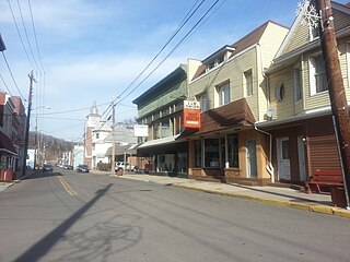
Berkeley Springs is a town in, and the county seat of, Morgan County, West Virginia, United States, in the state's Eastern Panhandle. Berkeley Springs is also commonly used to refer to the area in and around the Town of Bath. In 1776, the Virginia Legislature incorporated a town around the springs and named it Bath. Since 1802, it has been referred to by the name of its original post office, Berkeley Springs. The population was 758 at the 2020 census. It is part of the Hagerstown–Martinsburg metropolitan area.

References

  1. 1 2 "State & County QuickFacts". United States Census Bureau. Retrieved August 14, 2022.
  2. "Find a County". National Association of Counties. Retrieved June 7, 2011.
  3. "Archived copy". Archived from the original on September 23, 2001. Retrieved February 24, 2014.{{cite web}}: CS1 maint: archived copy as title (link)
  4. Canfield, Jack. "Mineral County". The West Virginia Encyclopedia. West Virginia Humanities Council. Retrieved August 30, 2016.
  5. Otis K. Rice & Stephen W. Brown, West Virginia: A History, 2nd ed., University Press of Kentucky, Lexington (1993), p. 240.
  6. United States Census Bureau, U.S. Decennial Census, Tables of Minor Civil Divisions in West Virginia, 1870–2010.
  7. "2010 Census Gazetteer Files". United States Census Bureau. August 22, 2012. Retrieved July 30, 2015.
  8. Deichert, Andy. "New Creek Site 14, Grant County, WV". Natural Resources Conservation Service West Virginia. United States Department of Agriculture. Retrieved October 19, 2016.
  9. "Annual Estimates of the Resident Population for Counties: April 1, 2020 to July 1, 2021" . Retrieved August 14, 2022.
  10. "U.S. Decennial Census". United States Census Bureau. Retrieved January 10, 2014.
  11. "Historical Census Browser". University of Virginia Library. Retrieved January 10, 2014.
  12. "Population of Counties by Decennial Census: 1900 to 1990". United States Census Bureau. Retrieved January 10, 2014.
  13. "Census 2000 PHC-T-4. Ranking Tables for Counties: 1990 and 2000" (PDF). United States Census Bureau. Archived (PDF) from the original on October 9, 2022. Retrieved January 10, 2014.
  14. "Explore Census Data". data.census.gov. Retrieved March 30, 2023.
  15. 1 2 3 "DP-1 Profile of General Population and Housing Characteristics: 2010 Demographic Profile Data". United States Census Bureau. Archived from the original on February 13, 2020. Retrieved April 3, 2016.
  16. "Population, Housing Units, Area, and Density: 2010 - County". United States Census Bureau. Archived from the original on February 13, 2020. Retrieved April 3, 2016.
  17. "DP02 SELECTED SOCIAL CHARACTERISTICS IN THE UNITED STATES – 2006-2010 American Community Survey 5-Year Estimates". United States Census Bureau. Archived from the original on February 13, 2020. Retrieved April 3, 2016.
  18. "DP03 SELECTED ECONOMIC CHARACTERISTICS – 2006-2010 American Community Survey 5-Year Estimates". United States Census Bureau. Archived from the original on February 13, 2020. Retrieved April 3, 2016.
  19. Schwartzman, Gabe; ‘How Central Appalachia Went Right’; Daily Yonder, January 13, 2015
  20. Cohn, Nate; ‘Demographic Shift: Southern Whites’ Loyalty to G.O.P. Nearing That of Blacks to Democrats’, New York Times , April 24, 2014
  21. Menendez, Albert J.; The Geography of Presidential Elections in the United States, 1868-2004, pp. 334-335 ISBN   0786422173
  22. Leip, David. "Dave Leip's Atlas of U.S. Presidential Elections". uselectionatlas.org. Retrieved March 28, 2018.
  23. "West Virginia State Constitution" (PDF). West Virginia State Legislature. Archived (PDF) from the original on October 9, 2022. Retrieved February 15, 2013.
  24. West Virginia State Code
  25. WV Constitution, Article 9, Section 11.
  26. Eastep, Alan. "Mineral County, WV Parks & Recreation - BEST West Virginia Places to Picnic Guide". www.alanskitchen.com. Retrieved October 13, 2018.
  27. Burnett, JoAnn. "Apple Alley Players | Welcome". applealleyplayers.com. Retrieved October 13, 2018.
  28. "About Us – Keyser Public Library" . Retrieved October 24, 2020.
  29. "Piedmont Public Library". piedmont.lib.wv.us. Retrieved April 16, 2023.

39°25′N78°56′W / 39.42°N 78.94°W / 39.42; -78.94