Doddridge County, West Virginia

Last updated

Doddridge County
Doddridge County Courthouse.jpg
Flag of Doddridge County, West Virginia.svg
Seal of Doddridge County, West Virginia.svg
Map of West Virginia highlighting Doddridge County.svg
Location within the U.S. state of West Virginia
West Virginia in United States.svg
West Virginia's location within the U.S.
Coordinates: 39°16′N80°42′W / 39.26°N 80.7°W / 39.26; -80.7
CountryFlag of the United States.svg United States
StateFlag of West Virginia.svg  West Virginia
FoundedFebruary 4, 1845
Named for Philip Doddridge
Seat West Union
Largest townWest Union
Area
  Total320 sq mi (800 km2)
  Land320 sq mi (800 km2)
  Water0.8 sq mi (2 km2)  0.2%
Population
 (2020)
  Total7,808
  Estimate 
(2021)
7,735 Decrease2.svg
  Density24/sq mi (9.4/km2)
Time zone UTC−5 (Eastern)
  Summer (DST) UTC−4 (EDT)
Congressional district 1st
Website www.doddridgecountywv.gov
Debar House (built 1852), St. Clara Colony, Doddridge County, [West] Virginia Diss Debar4.jpg
Debar House (built 1852), St. Clara Colony, Doddridge County, [West] Virginia

Doddridge County is a county in the U.S. state of West Virginia. As of the 2020 census, the population was 7,808. [1] Its county seat is West Union. [2]

Contents

Doddridge County is part of the Clarksburg, West Virginia, WV Micropolitan Statistical Area.

History

First settlers

The area that became Doddridge County, Virginia – now West Virginia – was first settled in the late 1780s by James Caldwell, who owned 20,000 acres (81 km2) of land that included present West Union. Caldwell sold this land to Nathan Davis, Jr (1772-1866) and his brothers Joseph and William around 1807. They in turn sold 16,000 acres (65 km2) to Lewis Maxwell (1790-1862), a Virginia Assembly delegate in the 1820s who later became a U.S. Congressman. In 1828 Ephraim Bee, Sr (1802–1888) and his wife Catherine established a log home on Meathouse Fork of Middle Island Creek, now part of West Union. They built an Inn across the "Creek" (really a river) at what was then called Lewisport (Congressman Maxwell's namesake), below a blockhouse on the Northwestern Turnpike. The "Beehive Inn" became a popular place for travelers and locals to meet, refresh themselves and re-provision. Bee operated the first local blacksmith shop; a farm, stables, tannery and horse-racing track soon followed.

According to Ephraim's father, A.A. Bee: "The first bridge across Middle Island Creek [at West Union] was of hewed logs with a center abutment of stones. In the great flood of 1835 it was washed away". In 1842, a contract was awarded to the well-known civil engineer Claudius Crozet to build a covered bridge at West Union, as part of a series of public works along the Turnpike. Ephraim Bee was later to become a district officer, magistrate, state legislator, hotelier, and postmaster. As blacksmith, he made all the bolts and bands for the West Union Covered Bridge, completed in 1843.

New county

Doddridge County was officially created in 1845 from parts of Harrison, Tyler, Ritchie, and Lewis Counties of what was then still Virginia. It was named for Philip Doddridge (1773–1832), the late statesman of western Virginia who was the leading voice for westerners during the Virginia Constitutional Convention of 1829–1830. [3] [4] [5] When it was announced the new county would be formed, Ephraim Bee rallied to locate the county seat at Lewisport. But Nathan Davis, Jr (who was Ephraim's wife's uncle), William Fitz Randolph, and others, won out in favor of West Union, across the river on the south side. There Ethelbert Bond (Nathan's son-in-law and William's wife's cousin) laid out the town lots in regular fashion on land formerly owned by Davis.

Progress of the Baltimore and Ohio Railroad, on its way from Clarksburg to Parkersburg, reached and bisected the county in 1856. [6]

On the night of March 27, 1858, a fire devastated the town of West Union.

West Virginia became a state following the Wheeling Conventions of 1861, after the American Civil War had begun.

In 1863, West Virginia's counties were divided into civil townships, with the intention of encouraging local government. This proved impractical in the heavily rural state, and in 1872 the townships were converted into magisterial districts. [7] Doddridge County was divided into six districts: Central, Grant, McClellan, New Milton, Southwest, and West Union. A seventh district, Greenbrier, was created from part of New Milton in 1885; and an eighth, Cove, was formed from part of Southwest District between 1890 and 1900. The historic magisterial districts were consolidated into four new districts between 1980 and 1990: Beech, Maple, Oak, and Pine. [8]

Maxwell Ridge – named for the Congressman's family – is said to have a cave (Gatrell Cave) that was used by the Underground Railroad in the years leading up to the Civil War. [9] Another nearby grotto, Jaco Cave, is said to have been used for the same purpose and is also featured in a movie from the 1970s called “No Drums, No Bugles” which features some locals as well as Martin Sheen, father of Charlie Sheen.

The county seat of West Union was incorporated on July 20, 1881.

Oil and gas boom

Doddridge County's oil and gas industry was an enormous boon to residents. The county's first oil pool, at Center Point, was discovered ("brought in" as it was then termed) and drilled in 1892. This was an extension of the technology and boom of the western Pennsylvania oil and gas fields into Tyler and Doddridge Counties. Many farm owners, and sons of farm owners, split their time between their farmwork and the petroleum operations. Almost every local farm benefited from this as free gas was piped to the farmhouses of many landowners. Gas was soon used for heating, lighting, and cooking, which replaced the wood stoves, kerosene and candles of previous generations. By 1906, the Ideal Glass Factory opened to take advantage of the abundant natural gas. It was followed by the Doddridge County Window Glass Company. The two plants employed about 300 people. In later years a garment factory opened, but closed in the mid-1990s.

A long-remembered flood devastated West Union in June 1950, destroying homes and businesses and killing more than 20 people throughout the county. (One casualty was the 107-year-old covered bridge.)

Today farming, timbering, oil and gas, and the business of county government and public education support the area, and many people commute to jobs in Salem, Clarksburg, and Parkersburg, or to the North Central Regional Jail in Greenwood. [9]

The Lathrop Russell Charter House, Doddridge County Courthouse, Silas P. Smith Opera House, and W. Scott Stuart House are individually listed on the National Register of Historic Places. [10] West Union is also home to two nationally recognized historic districts: West Union Downtown Historic District and West Union Residential Historic District.

Geography

According to the United States Census Bureau, the county has a total area of 320 square miles (830 km2), of which 320 square miles (830 km2) is land and 0.8 square miles (2.1 km2) (0.2%) is water. [11]

Major highways

Adjacent counties

Demographics

Historical population
CensusPop.Note
1850 2,750
1860 5,20389.2%
1870 7,07636.0%
1880 10,55249.1%
1890 12,18315.5%
1900 13,68912.4%
1910 12,672−7.4%
1920 11,976−5.5%
1930 10,488−12.4%
1940 10,9234.1%
1950 9,026−17.4%
1960 6,970−22.8%
1970 6,389−8.3%
1980 7,43316.3%
1990 6,994−5.9%
2000 7,4035.8%
2010 8,20210.8%
2020 7,808−4.8%
2021 (est.)7,735 [12] −0.9%
U.S. Decennial Census [13]
1790–1960 [14] 1900–1990 [15]
1990–2000 [16] 2010–2020 [1]

2020 census

As of the 2020 census, there were 7,808 people and 2,309 households residing in the county. There were 3,241 housing units in Doddridge. The racial makeup of the county was 93.5% White, 2.2% African American, 0.2% Asian, 0.2% Native American, 0.4% from other races, and 3.4% from two or more races.

Of the 2,309 households, 66.9% were married couples living together, 16.9% had a female householder with no spouse present, 13.6% had a male householder with no spouse present. The average household and family size was 3.65. The median age in the county was 46.2 years with 15.2% of the population under 18. The median income for a household was $58,750 and the poverty rate was 15.2%. [17]

2010 census

As of the census of 2010, the population was 8,202.

2000 census

As of the census of 2000, there were 7,403 people, 2,845 households, and 2,102 families living in the county. The population density was 23 people per square mile (8.9 people/km2). There were 3,661 housing units at an average density of 11 units per square mile (4.2 units/km2). The racial makeup of the county was 98.31% White, 0.27% Black or African American, 0.31% Native American, 0.15% Asian, 0.14% from other races, and 0.82% from two or more races. 0.57% of the population were Hispanic or Latino of any race.

There were 2,845 households, out of which 32.50% had children under the age of 18 living with them, 59.30% were married couples living together, 10.30% had a female householder with no husband present, and 26.10% were non-families. 22.50% of all households were made up of individuals, and 10.90% had someone living alone who was 65 years of age or older. The average household size was 2.56 and the average family size was 2.98.

In the county, the population was spread out, with 25.00% under the age of 18, 8.40% from 18 to 24, 26.60% from 25 to 44, 25.10% from 45 to 64, and 14.80% who were 65 years of age or older. The median age was 39 years. For every 100 females, there were 101.90 males. For every 100 females age 18 and over, there were 98.10 males.

The median income for a household in the county was $26,744, and the median income for a family was $30,502. Males had a median income of $26,902 versus $20,250 for females. The per capita income for the county was $13,507. About 15.30% of families and 19.80% of the population were below the poverty line, including 23.00% of those under age 18 and 13.60% of those age 65 or over.

2010 census

As of the 2010 United States census, there were 8,202 people, 3,099 households, and 2,169 families living in the county. [18] The population density was 25.7 inhabitants per square mile (9.9/km2). There were 3,946 housing units at an average density of 12.3 units per square mile (4.7 units/km2). [19] The racial makeup of the county was 97.0% white, 1.4% black or African American, 0.3% American Indian, 0.2% Asian, 0.1% from other races, and 1.1% from two or more races. Those of Hispanic or Latino origin made up 0.5% of the population. [18] In terms of ancestry, 24.3% were German, 16.8% were Irish, 11.7% were English, 10.3% were American, and 6.1% were French Canadian. [20]

Of the 3,099 households, 28.6% had children under the age of 18 living with them, 55.7% were married couples living together, 9.1% had a female householder with no husband present, 30.0% were non-families, and 26.1% of all households were made up of individuals. The average household size was 2.41 and the average family size was 2.87. The median age was 42.4 years. [18]

The median income for a household in the county was $30,019 and the median income for a family was $34,016. Males had a median income of $30,219 versus $21,121 for females. The per capita income for the county was $14,658. About 15.4% of families and 25.1% of the population were below the poverty line, including 36.7% of those under age 18 and 20.2% of those age 65 or over. [21]

Politics

After having leaned strongly towards the Democratic Party between the New Deal and Bill Clinton's presidency, most of West Virginia has since 2000 seen an extremely rapid swing towards the Republican Party due to declining unionization [22] and differences with the Democratic Party's liberal views on social issues. [23] In contrast, Doddridge County along with neighbouring Ritchie County and Tyler County were historically powerfully Unionist and have always been rock-ribbed Republican since the Civil War. Only two Democratic presidential candidates have won Doddridge County since West Virginia's statehood: Samuel J. Tilden in 1876, [24] and Lyndon Johnson – who won by just six votes – in 1964.

United States presidential election results for Doddridge County, West Virginia [25]
Year Republican Democratic Third party
No.%No.%No.%
2020 2,61984.46%43514.03%471.52%
2016 2,35882.36%36212.64%1434.99%
2012 2,13076.78%57520.73%692.49%
2008 2,21873.49%73524.35%652.15%
2004 2,36274.30%80025.17%170.53%
2000 1,95569.42%77327.45%883.13%
1996 1,33551.45%86533.33%39515.22%
1992 1,50050.13%96832.35%52417.51%
1988 1,88066.03%95533.54%120.42%
1984 2,34373.33%83626.17%160.50%
1980 1,88861.88%1,04334.19%1203.93%
1976 1,80459.17%1,24540.83%00.00%
1972 2,28477.98%64522.02%00.00%
1968 1,86165.28%84429.60%1465.12%
1964 1,58149.91%1,58750.09%00.00%
1960 2,40269.52%1,05330.48%00.00%
1956 2,59473.51%93526.49%00.00%
1952 2,74172.49%1,04027.51%00.00%
1948 2,43367.60%1,16632.40%00.00%
1944 2,61172.31%1,00027.69%00.00%
1940 3,29368.78%1,49531.22%00.00%
1936 3,02363.72%1,71636.17%50.11%
1932 2,78058.86%1,94341.14%00.00%
1928 2,91970.83%1,20229.17%00.00%
1924 2,77762.70%1,59435.99%581.31%
1920 3,13572.96%1,13726.46%250.58%
1916 1,80362.07%1,06136.52%411.41%
1912 62222.83%86631.79%1,23645.37%

Communities

Town

Magisterial districts

Unincorporated communities

Notable people

See also

Related Research Articles

<span class="mw-page-title-main">Barbour County, West Virginia</span> County in West Virginia, United States

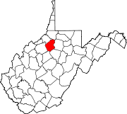
Barbour County is a county in north central West Virginia, United States. At the 2020 census, the population was 15,465. The county seat is Philippi, which was chartered in 1844. Both county and city were named for Philip P. Barbour (1783–1841), a U.S. Congressman from Virginia and Associate Justice of the U.S. Supreme Court. The county was formed in 1843 when the region was still part of the state of Virginia. In 1871, a small part of Barbour County was transferred to Tucker County, West Virginia.

<span class="mw-page-title-main">Wellsburg, West Virginia</span> City in West Virginia, United States

Wellsburg is a city in and the county seat of Brooke County, West Virginia, United States. The 2020 census recorded a population of 2,455. It is a part of the Weirton–Steubenville metropolitan area. The city's economy includes several telemarketing facilities, and a factory that does metal fabrication and plastics molding.

<span class="mw-page-title-main">Braxton County, West Virginia</span> County in West Virginia, United States

Braxton County is a county in the central part of the U.S. state of West Virginia. As of the 2020 census, the population was 12,447. The county seat is Sutton. The county was formed in 1836 from parts of Lewis, Kanawha, and Nicholas counties and named for Carter Braxton, a Virginia statesman and signer of the Declaration of Independence.

<span class="mw-page-title-main">Wood County, West Virginia</span> County in West Virginia, United States

Wood County is a county in the U.S. state of West Virginia. As of the 2020 census, the population was 84,296, making it West Virginia's fifth-most populous county. Its county seat is Parkersburg. The county was formed in 1798 from the western part of Harrison County and named for James Wood, governor of Virginia from 1796 to 1799.

<span class="mw-page-title-main">Wetzel County, West Virginia</span> County in West Virginia, United States

Wetzel County is a county in the U.S. state of West Virginia. As of the 2020 census, the population was 14,442. Its county seat is New Martinsville. The county, founded in 1846, is named for Lewis Wetzel, a famous frontiersman and Indian fighter. Its northern border aligns with the Mason-Dixon line, but is to the west of the line's western terminus.

<span class="mw-page-title-main">Webster County, West Virginia</span> County in West Virginia, United States

Webster County is a county in the U.S. state of West Virginia. As of the 2020 census, the population was 8,378. Its county seat is Webster Springs. The county was founded in 1860 and named for Daniel Webster.

<span class="mw-page-title-main">Upshur County, West Virginia</span> County in West Virginia, United States

Upshur County is a county in the U.S. state of West Virginia. As of the 2020 census, the population was 23,816. Its county seat is Buckhannon. The county was formed in 1851 from Randolph, Barbour, and Lewis counties and named for Abel Parker Upshur, a distinguished statesman and jurist of Virginia. Upshur served as United States Secretary of State and Secretary of the Navy under President John Tyler.

<span class="mw-page-title-main">Tyler County, West Virginia</span> County in West Virginia, United States

Tyler County is a county in the U.S. state of West Virginia. As of the 2020 census, the population was 8,313. Its county seat is Middlebourne. The county was founded in 1814 and is named after John Tyler, Sr., father of President John Tyler.

<span class="mw-page-title-main">Taylor County, West Virginia</span> County in West Virginia, United States

Taylor County is a county in the U.S. state of West Virginia. As of the 2020 census, the population was 16,705. Its county seat is Grafton. The county was formed in 1844 and named for Senator John Taylor of Caroline.

<span class="mw-page-title-main">Roane County, West Virginia</span> County in West Virginia, United States

Roane County is a county located in the U.S. state of West Virginia. As of the 2020 census, the population was 14,028. Its county seat is Spencer. The county was founded in 1856 and is named for Spencer Roane.

<span class="mw-page-title-main">Ritchie County, West Virginia</span> County in West Virginia, United States

Ritchie County is a county in the U.S. state of West Virginia. As of the 2020 census, the population was 8,444. Its county seat is Harrisville. The county was created in 1843 by the Virginia General Assembly and named for Richmond newspaper publisher Thomas Ritchie.

<span class="mw-page-title-main">Pleasants County, West Virginia</span> County in West Virginia, United States

Pleasants County is a county located in the U.S. state of West Virginia. At the 2020 census, the population was 7,653. Its county seat is St. Marys.

<span class="mw-page-title-main">Nicholas County, West Virginia</span> County in West Virginia, United States

Nicholas County is a county located in the central region of U.S. state of West Virginia. As of the 2020 census, the population was 24,604. Its county seat is Summersville. The county was created in 1818 by the Virginia General Assembly and named for Virginia Governor Wilson Cary Nicholas.

<span class="mw-page-title-main">Lewis County, West Virginia</span> County in West Virginia, United States

Lewis County is a county in the U.S. state of West Virginia. As of the 2020 census, the population was 17,033. Its county seat is Weston. The county was formed in 1816 from Harrison County.

<span class="mw-page-title-main">Jackson County, West Virginia</span> County in West Virginia, United States

Jackson County is a county in the U.S. state of West Virginia. As of the 2020 census, the population was 27,791. Its county seat is Ripley, and its largest municipality is Ravenswood.

<span class="mw-page-title-main">Grant County, West Virginia</span> County in West Virginia, United States

Grant County is a county in the U.S. state of West Virginia. As of the 2020 census, the population was 10,976. Its county seat is Petersburg. The county was created from Hardy County in 1866 and named for Civil War General and the 18th president of the United States Ulysses S. Grant.

<span class="mw-page-title-main">Gilmer County, West Virginia</span> County in West Virginia, United States

Gilmer County is a county in the U.S. state of West Virginia. As of the 2020 census, the population was 7,408, making it West Virginia's fifth-least populous county. Its county seat is Glenville. The county was formed in 1845 from parts of Lewis and Kanawha Counties, and named for Thomas Walker Gilmer, Governor of Virginia from 1840 to 1841. Gilmer was later a representative in the United States Congress and Secretary of the Navy in President John Tyler's cabinet.

<span class="mw-page-title-main">Miami County, Ohio</span> County in Ohio, United States

Miami County is a county located in the U.S. state of Ohio. As of the 2020 census, the population was 108,774. Its county seat is Troy. The county is named in honor of the Miami people.

<span class="mw-page-title-main">West Union, West Virginia</span> Town in West Virginia

West Union, incorporated July 20, 1881, is a town and the county seat of Doddridge County, West Virginia, United States. The population was 669 at the 2020 census. The town is located along Middle Island Creek at the junction of U.S. Route 50 and West Virginia Route 18; the North Bend Rail Trail also passes through the town.

<span class="mw-page-title-main">Belmont, West Virginia</span> Town in West Virginia, United States

Belmont is a town in Pleasants County, West Virginia, United States. It is part of the Parkersburg–Vienna metropolitan area. The population was 872 at the 2020 census. Belmont was incorporated on April 19, 1946 by the Circuit Court of Pleasants County. The city was named for the beautiful hills in the area.
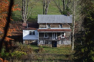
References

Citations

  1. 1 2 "State & County QuickFacts". United States Census Bureau. Retrieved October 20, 2022.
  2. "Find a County". National Association of Counties. Archived from the original on May 31, 2011. Retrieved June 7, 2011.
  3. Richards, Samuel J. (Fall 2019). "Reclaiming Congressman Philip Doddridge from Tidewater Cultural Imperialism". West Virginia History: A Journal of Regional Studies. 13 (2): 1–26. doi:10.1353/wvh.2019.0019. S2CID   211648744.
  4. Gannett, Henry (1905). The Origin of Certain Place Names in the United States. Govt. Print. Off. pp.  107.
  5. "Doddridge County history sources". Archived from the original on May 29, 2013. Retrieved January 29, 2013.
  6. A Reminiscent History of Northern West Virginia (1895); Chicago: Goodspeed Brothers [no author], pg 79.
  7. Otis K. Rice & Stephen W. Brown, West Virginia: A History, 2nd ed., University Press of Kentucky, Lexington (1993), p. 240.
  8. United States Census Bureau, U.S. Decennial Census, Tables of Minor Civil Divisions in West Virginia, 1870–2010.
  9. 1 2 Frank Engle McCallum (November 12, 2010). "The West Virginia Encyclopedia: West Union". West Virginia Humanities Council. Retrieved July 23, 2011.
  10. "National Register Information System". National Register of Historic Places . National Park Service. March 13, 2009.
  11. "2010 Census Gazetteer Files". United States Census Bureau. August 22, 2012. Retrieved July 24, 2015.
  12. "Annual Estimates of the Resident Population for Counties: April 1, 2020 to July 1, 2021" . Retrieved October 20, 2022.
  13. "U.S. Decennial Census". United States Census Bureau. Retrieved January 9, 2014.
  14. "Historical Census Browser". University of Virginia Library. Retrieved January 9, 2014.
  15. "Population of Counties by Decennial Census: 1900 to 1990". United States Census Bureau. Retrieved January 9, 2014.
  16. "Census 2000 PHC-T-4. Ranking Tables for Counties: 1990 and 2000" (PDF). United States Census Bureau. Archived (PDF) from the original on October 9, 2022. Retrieved January 9, 2014.
  17. "Explore Census Data". data.census.gov. Retrieved August 23, 2023.
  18. 1 2 3 "DP-1 Profile of General Population and Housing Characteristics: 2010 Demographic Profile Data". United States Census Bureau. Archived from the original on February 13, 2020. Retrieved April 3, 2016.
  19. "Population, Housing Units, Area, and Density: 2010 - County". United States Census Bureau. Archived from the original on February 13, 2020. Retrieved April 3, 2016.
  20. "DP02 SELECTED SOCIAL CHARACTERISTICS IN THE UNITED STATES – 2006-2010 American Community Survey 5-Year Estimates". United States Census Bureau. Archived from the original on February 13, 2020. Retrieved April 3, 2016.
  21. "DP03 SELECTED ECONOMIC CHARACTERISTICS – 2006-2010 American Community Survey 5-Year Estimates". United States Census Bureau. Archived from the original on February 13, 2020. Retrieved April 3, 2016.
  22. Schwartzman, Gabe; ‘How Central Appalachia Went Right’; Daily Yonder, January 13, 2015
  23. Cohn, Nate; ‘Demographic Shift: Southern Whites’ Loyalty to G.O.P. Nearing That of Blacks to Democrats’, The New York Times , April 24, 2014
  24. Menendez, Albert J.; The Geography of Presidential Elections in the United States, 1868-2004, pp. 334-337 ISBN   0786422173
  25. Leip, David. "Dave Leip's Atlas of U.S. Presidential Elections". uselectionatlas.org. Retrieved March 27, 2018.

Other sources

39°16′N80°42′W / 39.26°N 80.70°W / 39.26; -80.70