Pleasants County, West Virginia

Last updated

Pleasants County
Pleasants County Courthouse.jpg
Map of West Virginia highlighting Pleasants County.svg
Location within the U.S. state of West Virginia
West Virginia in United States.svg
West Virginia's location within the U.S.
Coordinates: 39°22′N81°10′W / 39.37°N 81.16°W / 39.37; -81.16
CountryFlag of the United States.svg United States
StateFlag of West Virginia.svg  West Virginia
FoundedMarch 29, 1851
Named for James Pleasants
Seat St. Marys
Largest citySt. Marys
Area
  Total135 sq mi (350 km2)
  Land130 sq mi (300 km2)
  Water4.4 sq mi (11 km2)  3.3%
Population
 (2020)
  Total7,653
  Estimate 
(2021)
7,601 Decrease2.svg
  Density57/sq mi (22/km2)
Time zone UTC−5 (Eastern)
  Summer (DST) UTC−4 (EDT)
Congressional district 1st
Website pleasantscountywv.org

Pleasants County is a county located in the U.S. state of West Virginia. At the 2020 census, the population was 7,653. [1] Its county seat is St. Marys. [2]

Contents

History

Pleasants County was formed by the Virginia General Assembly from portions of adjacent Wood, Ritchie and Tyler counties on March 29, 1851. The county's namesake is James Pleasants, Jr., an esteemed former US Senator and Virginia Governor. [3] [4] On June 20, 1863, at the height of the Civil War, Pleasants County was one of fifty Virginia counties that entered the Union as the state of West Virginia.

In 1863, West Virginia's counties were divided into civil townships, with the intention of encouraging local government. This proved impractical in the heavily rural state, and in 1872 the townships were converted into magisterial districts. [5] Pleasants County was divided into six districts: Grant, Jefferson, Lafayette, McKim, Union, and Washington. These remained largely unchanged for over a century, but in the 1980s the six historic magisterial districts were consolidated into four new districts: District A, District B, District C, and District D. [6]

Geography

According to the United States Census Bureau, the county has a total area of 135 square miles (350 km2), of which 130 square miles (340 km2) is land and 4.4 square miles (11 km2) (3.3%) is water. [7] It is the fourth-smallest county in West Virginia by area.

Major highways

Adjacent counties

National protected area

Demographics

Historical population
CensusPop.Note
1860 2,945
1870 3,0122.3%
1880 6,256107.7%
1890 7,53920.5%
1900 9,34524.0%
1910 8,074−13.6%
1920 7,379−8.6%
1930 6,545−11.3%
1940 6,6922.2%
1950 6,369−4.8%
1960 7,12411.9%
1970 7,2742.1%
1980 8,23613.2%
1990 7,546−8.4%
2000 7,514−0.4%
2010 7,6051.2%
2020 7,6530.6%
2021 (est.)7,601 [8] −0.7%
U.S. Decennial Census [9]
1790–1960 [10] 1900–1990 [11]
1990–2000 [12] 2010–2020 [1]

2020 census

As of the 2020 census, there were 7,653 people and 2,688 households residing in the county. There were 3,209 housing units in Pleasants county. The racial makeup of the county was 94.7% White, 1.2% African American, 0.2% Asian, 0.3% Native American, 0.3% from other races, and 3.3% from two or more races. Hispanics or Latinos of any race were 0.8% of the population.

Of the 2,688 households, 58.1% were married couples living together, 20.5% had a female householder with no spouse present, 18.2% had a male householder with no spouse present. The average household and family size was 3.06. The median age in the county was 43.1 years with 19.2% of the population under 18. The median income for a household was $58,433 and the poverty rate was 7.4%. [13]

2000 census

As of the census of 2000, there were 7,514 people, 2,887 households, and 2,136 families living in the county. The population density was 58 inhabitants per square mile (22/km2). There were 3,214 housing units at an average density of 25 units per square mile (9.7 units/km2). The racial makeup of the county was 98.30% White, 0.48% Black or African American, 0.47% Native American, 0.20% Asian, 0.07% from other races, and 0.49% from two or more races. 0.37% of the population were Hispanic or Latino of any race.

There were 2,887 households, out of which 32.70% had children under the age of 18 living with them, 60.10% were married couples living together, 10.40% had a female householder with no husband present, and 26.00% were non-families. 22.90% of all households were made up of individuals, and 12.30% had someone living alone who was 65 years of age or older. The average household size was 2.51 and the average family size was 2.93.

In the county, the population was spread out, with 23.80% under the age of 18, 7.80% from 18 to 24, 28.70% from 25 to 44, 24.80% from 45 to 64, and 14.90% who were 65 years of age or older. The median age was 39 years. For every 100 females there were 100.20 males. For every 100 females age 18 and over, there were 96.20 males.

The median income for a household in the county was $32,736, and the median income for a family was $37,795. Males had a median income of $31,068 versus $18,077 for females. The per capita income for the county was $16,920. About 10.90% of families and 13.70% of the population were below the poverty line, including 17.80% of those under age 18 and 7.90% of those age 65 or over.

2010 census

As of the 2010 United States census, there were 7,605 people, 2,861 households, and 2,021 families living in the county. [14] The population density was 58.5 inhabitants per square mile (22.6/km2). There were 3,390 housing units at an average density of 26.1 units per square mile (10.1 units/km2). [15] The racial makeup of the county was 97.3% white, 1.3% black or African American, 0.2% American Indian, 0.1% Asian, 0.1% from other races, and 1.0% from two or more races. Those of Hispanic or Latino origin made up 0.8% of the population. [14] In terms of ancestry, [16]

Of the 2,861 households, 31.0% had children under the age of 18 living with them, 56.1% were married couples living together, 9.8% had a female householder with no husband present, 29.4% were non-families, and 24.9% of all households were made up of individuals. The average household size was 2.44 and the average family size was 2.90. The median age was 42.4 years. [14]

The median income for a household in the county was $38,882 and the median income for a family was $54,391. Males had a median income of $52,738 versus $23,750 for females. The per capita income for the county was $18,770. About 6.7% of families and 13.7% of the population were below the poverty line, including 12.6% of those under age 18 and 10.8% of those age 65 or over. [17]

Education

In Pleasants County, there is a single school district including one high school, one middle school, and two elementary schools. The county is also served by the Mid Ohio Valley Technical Institute, which offers vocational education in a variety of fields. [18]

Politics

Although Pleasants County, like neighbouring rock-ribbed Unionist and Republican Ritchie, Doddridge and Tyler Counties, voted against secession at the Virginia Secession Convention, [19] during the Third Party System the county voted consistently Democratic. [20] However, from 1900 onwards the county has generally voted Republican except in strong Democratic election victories, and like all of West Virginia it has become rock-ribbed GOP in the twenty-first century as a consequence of de-unionization in the coal industry. [21]

United States presidential election results for Pleasants County, West Virginia [22]
Year Republican Democratic Third party
No.%No.%No.%
2020 2,74278.54%69920.02%501.43%
2016 2,35874.17%62119.53%2006.29%
2012 1,82564.24%95533.61%612.15%
2008 1,77259.56%1,14238.39%612.05%
2004 2,06160.00%1,34939.27%250.73%
2000 1,88458.73%1,26739.50%571.78%
1996 1,26539.89%1,47846.61%42813.50%
1992 1,24836.97%1,38741.08%74121.95%
1988 1,76155.26%1,42144.59%50.16%
1984 2,25560.54%1,45839.14%120.32%
1980 1,85253.73%1,49443.34%1012.93%
1976 1,60848.62%1,69951.38%00.00%
1972 2,02562.65%1,20737.35%00.00%
1968 1,53447.06%1,52246.69%2046.26%
1964 1,33936.93%2,28763.07%00.00%
1960 1,98253.22%1,74246.78%00.00%
1956 2,14457.56%1,58142.44%00.00%
1952 1,90053.79%1,63246.21%00.00%
1948 1,54849.95%1,53649.56%150.48%
1944 1,62251.84%1,50748.16%00.00%
1940 1,89651.59%1,77948.41%00.00%
1936 1,82048.73%1,90751.06%80.21%
1932 1,58044.82%1,92154.50%240.68%
1928 1,82160.06%1,21039.91%10.03%
1924 1,61948.72%1,67550.41%290.87%
1920 1,65752.91%1,44946.26%260.83%
1916 87649.16%89950.45%70.39%
1912 49329.43%79647.52%38623.04%

Communities

Cities

Towns

Magisterial districts

Current

  • District A
  • District B
  • District C
  • District D

Historic

  • Grant
  • Jefferson
  • Lafayette
  • McKim
  • Union
  • Washington

Unincorporated communities

See also

Related Research Articles

<span class="mw-page-title-main">Clay County, West Virginia</span> County in West Virginia, United States

Clay County is a county in the U.S. state of West Virginia. As of the 2020 census, the population was 8,051. Its county seat is Clay. The county was founded in 1858 and named in honor of Henry Clay, famous American statesman, member of the United States Senate from Kentucky and United States Secretary of State in the 19th century.

<span class="mw-page-title-main">Braxton County, West Virginia</span> County in West Virginia, United States

Braxton County is a county in the central part of the U.S. state of West Virginia. As of the 2020 census, the population was 12,447. The county seat is Sutton. The county was formed in 1836 from parts of Lewis, Kanawha, and Nicholas counties and named for Carter Braxton, a Virginia statesman and signer of the Declaration of Independence.

<span class="mw-page-title-main">Wyoming County, West Virginia</span> County in West Virginia, United States

Wyoming County is a county in the U.S. state of West Virginia. As of the 2020 census, the population was 21,382. Its county seat is Pineville. The county was created in 1850 from Logan County and named for the Lenape word meaning "large plains".

<span class="mw-page-title-main">Wood County, West Virginia</span> County in West Virginia, United States

Wood County is a county in the U.S. state of West Virginia. As of the 2020 census, the population was 84,296, making it West Virginia's fifth-most populous county. Its county seat is Parkersburg. The county was formed in 1798 from the western part of Harrison County and named for James Wood, governor of Virginia from 1796 to 1799.

<span class="mw-page-title-main">Webster County, West Virginia</span> County in West Virginia, United States

Webster County is a county in the U.S. state of West Virginia. As of the 2020 census, the population was 8,378. Its county seat is Webster Springs. The county was founded in 1860 and named for Daniel Webster.

<span class="mw-page-title-main">Upshur County, West Virginia</span> County in West Virginia, United States

Upshur County is a county in the U.S. state of West Virginia. As of the 2020 census, the population was 23,816. Its county seat is Buckhannon. The county was formed in 1851 from Randolph, Barbour, and Lewis counties and named for Abel Parker Upshur, a distinguished statesman and jurist of Virginia. Upshur served as United States Secretary of State and Secretary of the Navy under President John Tyler.

<span class="mw-page-title-main">Tyler County, West Virginia</span> County in West Virginia, United States

Tyler County is a county in the U.S. state of West Virginia. As of the 2020 census, the population was 8,313. Its county seat is Middlebourne. The county was founded in 1814 and is named after John Tyler, Sr., father of President John Tyler.

<span class="mw-page-title-main">Tucker County, West Virginia</span> County in West Virginia, United States

Tucker County is a county in the U.S. state of West Virginia. As of the 2020 census, the population was 6,762, making it West Virginia's fourth-least populous county. Its county seat is Parsons. The county was created in 1856 from a part of Randolph County, then part of Virginia. In 1871, a small part of Barbour County, was transferred to Tucker County. The county was named after Henry St. George Tucker, Sr., a judge and Congressman from Williamsburg, Virginia.

<span class="mw-page-title-main">Roane County, West Virginia</span> County in West Virginia, United States

Roane County is a county located in the U.S. state of West Virginia. As of the 2020 census, the population was 14,028. Its county seat is Spencer. The county was founded in 1856 and is named for Spencer Roane.

<span class="mw-page-title-main">Ritchie County, West Virginia</span> County in West Virginia, United States

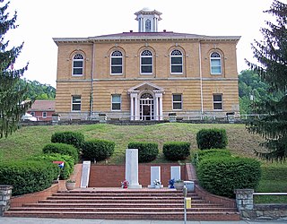
Ritchie County is a county in the U.S. state of West Virginia. As of the 2020 census, the population was 8,444. Its county seat is Harrisville. The county was created in 1843 by the Virginia General Assembly and named for Richmond newspaper publisher Thomas Ritchie.

<span class="mw-page-title-main">Nicholas County, West Virginia</span> County in West Virginia, United States

Nicholas County is a county located in the central region of U.S. state of West Virginia. As of the 2020 census, the population was 24,604. Its county seat is Summersville. The county was created in 1818 by the Virginia General Assembly and named for Virginia Governor Wilson Cary Nicholas.

<span class="mw-page-title-main">Lincoln County, West Virginia</span> County in West Virginia, United States

Lincoln County is a county in the U.S. state of West Virginia. As of the 2020 census, the population was 20,463. Its county seat is Hamlin. The county was created in 1867 and named for Abraham Lincoln.

<span class="mw-page-title-main">Lewis County, West Virginia</span> County in West Virginia, United States

Lewis County is a county in the U.S. state of West Virginia. As of the 2020 census, the population was 17,033. Its county seat is Weston. The county was formed in 1816 from Harrison County.

<span class="mw-page-title-main">Calhoun County, West Virginia</span> County in West Virginia, United States

Calhoun County is a county in the U.S. state of West Virginia. As of the 2020 census, the population was 6,229, making it the third-least populous county in West Virginia. Its county seat is Grantsville. The county was founded in 1856 and named for South Carolina politician John C. Calhoun.

<span class="mw-page-title-main">Marion County, Ohio</span> County in Ohio, United States

Marion County is a county located in the U.S. state of Ohio. As of the 2020 census, the population was 65,359. Its county seat is Marion. The county was created in 1820 and later organized in 1824. It is named for General Francis "The Swamp Fox" Marion, a South Carolinian officer in the Revolutionary War.

<span class="mw-page-title-main">Henry County, Ohio</span> County in Ohio, United States

Henry County is a county located in the U.S. state of Ohio. As of the 2020 census, the population was 27,662. Its county seat is Napoleon. The county was created in 1820 and later organized in 1834. It is named for American Founding Father Patrick Henry, the Virginian famous for his "give me liberty, or give me death!" speech.

<span class="mw-page-title-main">Rupert, West Virginia</span> Town in West Virginia, United States

Rupert is a town in Greenbrier County, West Virginia, United States. The population was 881 at the 2020 census.

<span class="mw-page-title-main">Pleasant Valley, Marion County, West Virginia</span> City in West Virginia, United States

Pleasant Valley is a city in Marion County, West Virginia, United States. The population was 3,506 at the 2020 census.

<span class="mw-page-title-main">Belmont, West Virginia</span> Town in West Virginia, United States

Belmont is a town in Pleasants County, West Virginia, United States. It is part of the Parkersburg–Vienna metropolitan area. The population was 872 at the 2020 census. Belmont was incorporated on April 19, 1946 by the Circuit Court of Pleasants County. The city was named for the beautiful hills in the area.

<span class="mw-page-title-main">St. Marys, West Virginia</span> City in West Virginia, United States

St. Marys is a city and the county seat of Pleasants County, West Virginia, United States. The population was 1,847 at the 2020 census. It is part of the Parkersburg–Vienna metropolitan area. St. Marys was established in 1849 by Alexander Creel, who is said to have had a vision of Mary while passing the townsite by boat on the Ohio River.

References

  1. 1 2 "State & County QuickFacts". United States Census Bureau. Retrieved October 20, 2022.
  2. "Find a County". National Association of Counties. Retrieved June 7, 2011.
  3. "Archived copy". Archived from the original on September 23, 2001. Retrieved February 4, 2013.{{cite web}}: CS1 maint: archived copy as title (link)
  4. e-WV The West Virginia Encyclopedia: Pleasants County. Accessed April 16, 2022.
  5. Otis K. Rice & Stephen W. Brown, West Virginia: A History, 2nd ed., University Press of Kentucky, Lexington (1993), p. 240.
  6. United States Census Bureau, U.S. Decennial Census, Tables of Minor Civil Divisions in West Virginia, 1870–2010.
  7. "2010 Census Gazetteer Files". United States Census Bureau. August 22, 2012. Retrieved July 30, 2015.
  8. "Annual Estimates of the Resident Population for Counties: April 1, 2020 to July 1, 2021" . Retrieved October 20, 2022.
  9. "U.S. Decennial Census". United States Census Bureau. Retrieved January 11, 2014.
  10. "Historical Census Browser". University of Virginia Library. Retrieved January 11, 2014.
  11. "Population of Counties by Decennial Census: 1900 to 1990". United States Census Bureau. Retrieved January 11, 2014.
  12. "Census 2000 PHC-T-4. Ranking Tables for Counties: 1990 and 2000" (PDF). United States Census Bureau. Archived (PDF) from the original on October 9, 2022. Retrieved January 11, 2014.
  13. "Explore Census Data".
  14. 1 2 3 "DP-1 Profile of General Population and Housing Characteristics: 2010 Demographic Profile Data". United States Census Bureau. Archived from the original on February 13, 2020. Retrieved April 3, 2016.
  15. "Population, Housing Units, Area, and Density: 2010 - County". United States Census Bureau. Archived from the original on February 13, 2020. Retrieved April 3, 2016.
  16. "DP02 SELECTED SOCIAL CHARACTERISTICS IN THE UNITED STATES – 2006-2010 American Community Survey 5-Year Estimates". United States Census Bureau. Archived from the original on February 13, 2020. Retrieved April 3, 2016.
  17. "DP03 SELECTED ECONOMIC CHARACTERISTICS – 2006-2010 American Community Survey 5-Year Estimates". United States Census Bureau. Archived from the original on February 13, 2020. Retrieved April 3, 2016.
  18. "Pleasants County, West Virginia - Education". pleasantscountywv.net. Retrieved March 28, 2018.
  19. Hinkle, Harlan H.; Grayback Mountaineers: The Confederate Face Of Western Virginia, p. 198 ISBN   0595268404
  20. Menendez, Albert J.; The Geography of Presidential Elections in the United States, 1868-2004, pp. 334-337 ISBN   0786422173
  21. Schwartzman, Gabe; ‘How Central Appalachia Went Right’; Daily Yonder, January 13, 2015
  22. Leip, David. "Dave Leip's Atlas of U.S. Presidential Elections". uselectionatlas.org. Retrieved March 28, 2018.

39°22′N81°10′W / 39.37°N 81.16°W / 39.37; -81.16