Ritchie County, West Virginia

Last updated

Ritchie County
Ritchie County Courthouse.jpg
Map of West Virginia highlighting Ritchie County.svg
Location within the U.S. state of West Virginia
West Virginia in United States.svg
West Virginia's location within the U.S.
Coordinates: 39°11′N81°04′W / 39.18°N 81.07°W / 39.18; -81.07
CountryFlag of the United States.svg United States
StateFlag of West Virginia.svg  West Virginia
FoundedFebruary 18, 1843
Named for Thomas Ritchie
Seat Harrisville
Largest townHarrisville
Area
  Total454 sq mi (1,180 km2)
  Land452 sq mi (1,170 km2)
  Water1.7 sq mi (4 km2)  0.4%
Population
 (2020)
  Total8,444
  Estimate 
(2021)
8,383 Decrease2.svg
  Density19/sq mi (7.2/km2)
Time zone UTC−5 (Eastern)
  Summer (DST) UTC−4 (EDT)
Congressional district 1st
Website www.ritchiecounty.wv.gov

Ritchie County is a county in the U.S. state of West Virginia. As of the 2020 census, the population was 8,444. [1] Its county seat is Harrisville. [2] The county was created in 1843 by the Virginia General Assembly and named for Richmond newspaper publisher Thomas Ritchie. [3]

Contents

History

Ritchie was one of fifty Virginia counties that were admitted to the Union as the state of West Virginia on June 20, 1863, at the height of the Civil War. Later that year, the new state's counties were divided into civil townships, with the intention of encouraging local government. This proved impractical in the heavily rural state, and in 1872 the townships were converted into magisterial districts. [4] Ritchie County was divided into four districts: Clay, Grant, Murphy, and Union. [5]

In 1911, historian Minnie Kendall Lowther published "The History of Ritchie County." Her book is still regarded as one of the most comprehensive histories of any county in West Virginia. [6]

Geography

According to the United States Census Bureau, the county has a total area of 454 square miles (1,180 km2), of which 452 square miles (1,170 km2) is land and 1.7 square miles (4.4 km2) (0.4%) is water. [7]

Major highways

Adjacent counties

Demographics

Historical population
CensusPop.Note
1850 3,902
1860 6,84775.5%
1870 9,05532.2%
1880 13,47448.8%
1890 16,62123.4%
1900 18,90113.7%
1910 17,875−5.4%
1920 16,506−7.7%
1930 15,594−5.5%
1940 15,389−1.3%
1950 12,535−18.5%
1960 10,877−13.2%
1970 10,145−6.7%
1980 11,44212.8%
1990 10,233−10.6%
2000 10,3431.1%
2010 10,4491.0%
2020 8,444−19.2%
2021 (est.)8,383 [8] −0.7%
U.S. Decennial Census [9]
1790–1960 [10] 1900–1990 [11]
1990–2000 [12] 2010–2020 [1]

2000 census

As of the census of 2000, there were 10,343 people, 4,184 households, and 2,999 families living in the county. The population density was 23 people per square mile (8.9 people/km2). There were 5,513 housing units at an average density of 12 units per square mile (4.6 units/km2). The racial makeup of the county was 98.68% White, 0.14% Black or African American, 0.27% Native American, 0.13% Asian, 0.11% from other races, and 0.69% from two or more races. 0.47% of the population were Hispanic or Latino of any race.

There were 4,184 households, out of which 30.20% had children under the age of 18 living with them, 58.20% were married couples living together, 9.70% had a female householder with no husband present, and 28.30% were non-families. 25.00% of all households were made up of individuals, and 12.30% had someone living alone who was 65 years of age or older. The average household size was 2.45 and the average family size was 2.91.

In the county, the population was spread out, with 23.00% under the age of 18, 7.70% from 18 to 24, 28.00% from 25 to 44, 26.10% from 45 to 64, and 15.20% who were 65 years of age or older. The median age was 40 years. For every 100 females there were 96.20 males. For every 100 females age 18 and over, there were 95.10 males.

The median income for a household in the county was $27,332, and the median income for a family was $34,809. Males had a median income of $28,147 versus $18,149 for females. The per capita income for the county was $15,175. About 14.30% of families and 19.10% of the population were below the poverty line, including 23.60% of those under age 18 and 14.10% of those age 65 or over.

2010 census

As of the 2010 United States census, there were 10,449 people, 4,367 households, and 2,960 families living in the county. [13] The population density was 23.1 inhabitants per square mile (8.9/km2). There were 5,843 housing units at an average density of 12.9 units per square mile (5.0 units/km2). [14] The racial makeup of the county was 98.7% white, 0.2% black or African American, 0.1% Asian, 0.1% American Indian, 0.2% from other races, and 0.8% from two or more races. Those of Hispanic or Latino origin made up 0.5% of the population. [13] In terms of ancestry, 20.3% were German, 14.6% were Irish, 13.2% were American, and 11.3% were English. [15]

Of the 4,367 households, 28.2% had children under the age of 18 living with them, 53.2% were married couples living together, 9.8% had a female householder with no husband present, 32.2% were non-families, and 28.2% of all households were made up of individuals. The average household size was 2.37 and the average family size was 2.85. The median age was 44.3 years. [13]

The median income for a household in the county was $32,619 and the median income for a family was $39,919. Males had a median income of $31,807 versus $23,966 for females. The per capita income for the county was $18,255. About 13.9% of families and 18.9% of the population were below the poverty line, including 21.6% of those under age 18 and 15.2% of those age 65 or over. [16]

Politics

After having leaned strongly towards the Democratic Party between the New Deal and Bill Clinton's presidency, most of West Virginia has since 2000 seen an extremely rapid swing towards the Republican Party due to declining unionization [17] along with views on environmental, social and cultural issues increasingly at odds with the national Democratic party. [18] In contrast, Ritchie County along with neighbouring Doddridge County and Tyler County were historically powerfully Unionist and have always been solidly Republican since the Civil War. Only one Democratic presidential nominee has carried Ritchie County since West Virginia's statehood: Woodrow Wilson in 1912, and he won by a mere six votes with only 34.22 percent of all votes against a Republican Party mortally divided between conservative incumbent Taft and progressive Theodore Roosevelt. [19]

United States presidential election results for Ritchie County, West Virginia [20]
Year Republican Democratic Third party
No.%No.%No.%
2020 3,64985.20%58613.68%481.12%
2016 3,40582.95%49612.08%2044.97%
2012 2,92177.07%76820.26%1012.66%
2008 2,78172.31%99825.95%671.74%
2004 3,08673.55%1,07025.50%400.95%
2000 2,71771.27%1,02426.86%711.86%
1996 1,90649.75%1,38536.15%54014.10%
1992 2,18449.46%1,47433.38%75817.16%
1988 2,87466.25%1,44633.33%180.41%
1984 3,35572.79%1,23126.71%230.50%
1980 3,08165.68%1,45030.91%1603.41%
1976 2,87459.69%1,94140.31%00.00%
1972 3,63578.59%99021.41%00.00%
1968 3,10666.50%1,28127.42%2846.08%
1964 2,71754.77%2,24445.23%00.00%
1960 3,97271.40%1,59128.60%00.00%
1956 4,14073.78%1,47126.22%00.00%
1952 4,23871.79%1,66528.21%00.00%
1948 3,61967.71%1,71232.03%140.26%
1944 3,96370.60%1,65029.40%00.00%
1940 4,98267.13%2,43932.87%00.00%
1936 4,63961.97%2,82537.74%220.29%
1932 4,05555.42%3,17943.45%831.13%
1928 4,19570.40%1,71128.71%530.89%
1924 4,15262.61%2,40336.23%771.16%
1920 4,37767.39%2,05031.56%681.05%
1916 2,22556.03%1,65741.73%892.24%
1912 93726.31%1,27035.65%1,35538.04%

Notable sights

Communities

City

Towns

Magisterial districts

Unincorporated communities

Notes

    Related Research Articles

    <span class="mw-page-title-main">Clay County, West Virginia</span> County in West Virginia, United States

    Clay County is a county in the U.S. state of West Virginia. As of the 2020 census, the population was 8,051. Its county seat is Clay. The county was founded in 1858 and named in honor of Henry Clay, famous American statesman, member of the United States Senate from Kentucky and United States Secretary of State in the 19th century.

    <span class="mw-page-title-main">Wood County, West Virginia</span> County in West Virginia, United States

    Wood County is a county in the U.S. state of West Virginia. As of the 2020 census, the population was 84,296, making it West Virginia's fifth-most populous county. Its county seat is Parkersburg. The county was formed in 1798 from the western part of Harrison County and named for James Wood, governor of Virginia from 1796 to 1799.

    <span class="mw-page-title-main">Wirt County, West Virginia</span> County in West Virginia, United States

    Wirt County is a county in the U.S. state of West Virginia. As of the 2020 census, the population was 5,194, making it the least populous county in West Virginia. Its county seat is Elizabeth. The county was created in 1848 by the Virginia General Assembly and named for U.S. Attorney General and presidential candidate William Wirt. The county is served by one high school, Wirt County High School.

    <span class="mw-page-title-main">Pleasants County, West Virginia</span> County in West Virginia, United States

    Pleasants County is a county located in the U.S. state of West Virginia. At the 2020 census, the population was 7,653. Its county seat is St. Marys.

    <span class="mw-page-title-main">Lewis County, West Virginia</span> County in West Virginia, United States

    Lewis County is a county in the U.S. state of West Virginia. As of the 2020 census, the population was 17,033. Its county seat is Weston. The county was formed in 1816 from Harrison County.

    <span class="mw-page-title-main">Calhoun County, West Virginia</span> County in West Virginia, United States

    Calhoun County is a county in the U.S. state of West Virginia. As of the 2020 census, the population was 6,229, making it the third-least populous county in West Virginia. Its county seat is Grantsville. The county was founded in 1856 and named for South Carolina politician John C. Calhoun.

    <span class="mw-page-title-main">Harrison County, Ohio</span> County in Ohio, United States

    Harrison County is a county located in the U.S. state of Ohio. As of the 2020 census, the population was 14,483, making it the fifth-least populous county in Ohio. Its county seat and largest village is Cadiz. The county is named for General William Henry Harrison, who was later President of the United States.

    <span class="mw-page-title-main">Cheshire County, New Hampshire</span> County in New Hampshire, United States

    Cheshire County is a county in the southwestern corner of the U.S. state of New Hampshire. As of the 2020 census, the population was 76,458. Its county seat is the city of Keene. Cheshire was one of the five original counties of New Hampshire, and is named for the county of Cheshire in England. It was organized in 1771 at Keene. Sullivan County was created from the northern portion of Cheshire County in 1827.

    <span class="mw-page-title-main">Harrisville Township, Michigan</span> Civil township in Michigan, United States

    Harrisville Township is a civil township of Alcona County in the U.S. state of Michigan. The population was 1,307 at the 2020 census. Harrisville Township surrounds the city of Harrisville, but the two are administered autonomously.

    <span class="mw-page-title-main">Harrisville, New Hampshire</span> Town in New Hampshire, United States

    Harrisville is a town in Cheshire County, New Hampshire, United States. Besides the town center, it also includes the villages of Chesham and Eastview. The population of the town was 984 at the 2020 census.

    <span class="mw-page-title-main">Harrisville, Pennsylvania</span> Borough in Pennsylvania, United States

    Harrisville is a borough in Butler County, Pennsylvania, United States. The population was 897 at the 2010 census.

    <span class="mw-page-title-main">Harrisville, Rhode Island</span> Census-designated place in Rhode Island, United States

    Harrisville is a census-designated place (CDP) and village in the town of Burrillville in Providence County, Rhode Island, United States. The population was 1,605 at the 2010 census. Much of the community composes a historic district listed on the National Register of Historic Places. The village was named after nineteenth century manufacturer Andrew Harris. Previously, the village was named Rhodesville, after Captain William Rhodes, an eighteenth century privateer.

    <span class="mw-page-title-main">Harrisville, Utah</span> City in Utah, United States

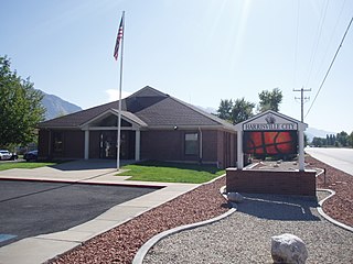
    Harrisville is a city in Weber County, Utah, United States. The population was 5,567 at the 2010 census. It is part of the Ogden–Clearfield, Utah Metropolitan Statistical Area. The current mayor is Michelle Tait.

    <span class="mw-page-title-main">West Milford, West Virginia</span> Town in West Virginia, United States

    West Milford is a town in Harrison County, West Virginia, United States. The population was 452 at the 2020 census.

    <span class="mw-page-title-main">Worthington, West Virginia</span> Town in West Virginia, United States

    Worthington is a town in Marion County, West Virginia, United States. The population was 158 at the 2010 census. Worthington was incorporated in 1893 and named for Colonel George Worthington, an early settler. U.S. Route 19 passes through the town.

    <span class="mw-page-title-main">War, West Virginia</span> City in West Virginia, United States

    War is a city in McDowell County, West Virginia, United States. The population was 690 at the 2020 census. War was incorporated in 1920 by the Circuit Court of McDowell County. Its name is derived from War Creek, whose confluence with Dry Fork is located within the city. War is the only place in the United States with this name. War was formerly known as Miner's City. It is also known for being a setting in the movie October Sky; as writer Homer Hickam's Big Creek High School.

    <span class="mw-page-title-main">Ellenboro, West Virginia</span> Town in West Virginia, United States

    Ellenboro is a town in Ritchie County, West Virginia, United States. The population was 222 at the 2020 census. The town is located at the junction of U.S. Route 50 and West Virginia Route 16; the North Bend Rail Trail also passes through the town. The town was named for Ellen Mariah Williamson, the eldest daughter of the family that granted a right of way for the Baltimore and Ohio Railroad to build their line through the town; an earlier name for the community was Shumley. Ellenboro was incorporated in 1903.

    <span class="mw-page-title-main">Harrisville, West Virginia</span> Town in West Virginia, United States

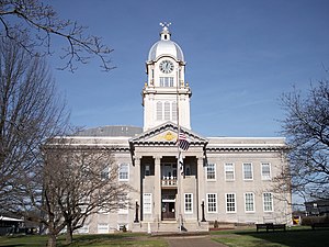
    Harrisville is a town and the county seat of Ritchie County, West Virginia, United States. Harrisville is located at the junction of State Routes 31 and 16, five miles south of U.S. 50. Within the community are an elementary school, the county board of education, many businesses, three banks, a library, offices of the Ritchie Gazette and The Pennsboro News, a municipal park, and North Bend Golf Course. North Bend Lake and North Bend State Park are located just outside town limits. Municipal elections are held every two years.

    <span class="mw-page-title-main">Pullman, West Virginia</span> Town in West Virginia, United States

    Pullman is a town in Ritchie County, West Virginia, United States. The population was 134 at the 2020 census.

    <span class="mw-page-title-main">Middlebourne, West Virginia</span> Town in West Virginia, United States

    Middlebourne is a town and the county seat of Tyler County, West Virginia, United States. The population was 715 at the 2020 census.

    References

    1. 1 2 "State & County QuickFacts". United States Census Bureau. Retrieved October 20, 2022.
    2. "Find a County". National Association of Counties. Retrieved June 7, 2011.
    3. "Ritchie County history sources". Archived from the original on May 29, 2013. Retrieved January 29, 2013.
    4. Otis K. Rice & Stephen W. Brown, West Virginia: A History, 2nd ed., University Press of Kentucky, Lexington (1993), p. 240.
    5. United States Census Bureau, U.S. Decennial Census, Tables of Minor Civil Divisions in West Virginia, 1870–2010.
    6. "September 18, 1947: Historian Minnie Kendall Lowther Dies in Harrisville". West Virginia Public Broadcasting . August 26, 2015. Retrieved September 20, 2015.
    7. "2010 Census Gazetteer Files". United States Census Bureau. August 22, 2012. Retrieved July 30, 2015.
    8. "Annual Estimates of the Resident Population for Counties: April 1, 2020 to July 1, 2021" . Retrieved October 20, 2022.
    9. "U.S. Decennial Census". United States Census Bureau. Retrieved January 11, 2014.
    10. "Historical Census Browser". University of Virginia Library. Retrieved January 11, 2014.
    11. "Population of Counties by Decennial Census: 1900 to 1990". United States Census Bureau. Retrieved January 11, 2014.
    12. "Census 2000 PHC-T-4. Ranking Tables for Counties: 1990 and 2000" (PDF). United States Census Bureau. Archived (PDF) from the original on October 9, 2022. Retrieved January 11, 2014.
    13. 1 2 3 "DP-1 Profile of General Population and Housing Characteristics: 2010 Demographic Profile Data". United States Census Bureau. Archived from the original on February 13, 2020. Retrieved April 3, 2016.
    14. "Population, Housing Units, Area, and Density: 2010 - County". United States Census Bureau. Archived from the original on February 13, 2020. Retrieved April 3, 2016.
    15. "DP02 SELECTED SOCIAL CHARACTERISTICS IN THE UNITED STATES – 2006-2010 American Community Survey 5-Year Estimates". United States Census Bureau. Archived from the original on February 13, 2020. Retrieved April 3, 2016.
    16. "DP03 SELECTED ECONOMIC CHARACTERISTICS – 2006-2010 American Community Survey 5-Year Estimates". United States Census Bureau. Archived from the original on February 13, 2020. Retrieved April 3, 2016.
    17. Schwartzman, Gabe; ‘How Central Appalachia Went Right’; Daily Yonder, January 13, 2015
    18. Cohn, Nate; ‘Demographic Shift: Southern Whites’ Loyalty to G.O.P. Nearing That of Blacks to Democrats’, New York Times , April 24, 2014
    19. "Presidential Election of 1912 – Map by Counties (.xlsx file for €15)". Géoelections. Archived from the original on June 13, 2018. Retrieved June 6, 2017.
    20. Leip, David. "Dave Leip's Atlas of U.S. Presidential Elections". uselectionatlas.org. Retrieved March 28, 2018.

    39°11′N81°04′W / 39.18°N 81.07°W / 39.18; -81.07