
Ritchie County is a county in the U.S. state of West Virginia. As of the 2010 census, the population was 10,449. Its county seat is Harrisville. The county was created in 1843 by the Virginia General Assembly and named for Richmond newspaper publisher Thomas Ritchie.
Harrison County is a county in the U.S. state of West Virginia. As of the 2010 census, the population was 69,099. The county seat is Clarksburg.

Calhoun County is a county in the U.S. state of West Virginia. As of the 2010 census, the population was 7,627. Its county seat is Grantsville. The county was founded in 1856 and named for South Carolina politician John C. Calhoun.

The Shenandoah River is a tributary of the Potomac River, 55.6 miles (89.5 km) long with two forks approximately 100 miles (160 km) long each, in the U.S. states of Virginia and West Virginia. The principal tributary of the Potomac, the river and its tributaries drain the central and lower Shenandoah Valley and the Page Valley in the Appalachians on the west side of the Blue Ridge Mountains, in northwestern Virginia and the Eastern Panhandle of West Virginia.

The Hughes River is a tributary of the Little Kanawha River in western West Virginia in the United States. Via the Little Kanawha and Ohio Rivers, it is part of the watershed of the Mississippi River. As measured from the confluence of its north and south forks, the Hughes is 18 mi (29 km) long, and drains a rural area of the unglaciated portion of the Allegheny Plateau.

West Virginia's 1st congressional district is located in the northern part of the state. It is the most regularly drawn of the state's three districts.

Shavers Fork of the Cheat River is situated in the Allegheny Mountains of eastern West Virginia, USA. It is 88.5 mi (142.5 km) long and forms the Cheat at its confluence with Black Fork at Parsons. It was traditionally considered one of the five Forks of Cheat and its upper reaches constitute the highest river in the eastern United States.

The Dry Fork is a 39.1-mile-long (62.9 km) tributary of the Black Fork of the Cheat River in the Allegheny Mountains of eastern West Virginia, USA. Via the Black Fork, the Cheat, and the Monongahela and Ohio rivers, it is part of the watershed of the Mississippi River. The Dry Fork flows for much of its length in the Monongahela National Forest and drains mostly rural and forested areas. It was traditionally considered one of the five Forks of Cheat.

State Route 80 is a primary state highway in the southwest part of the U.S. state of Virginia. It runs from the Kentucky state line at Breaks Interstate Park east to U.S. Route 11 near Meadowview. Kentucky Route 80 and Missouri's Route 80 continue the number west to Matthews, Missouri.

North Bend State Park sits on 2,459 acres (995 ha) along the North Fork of the Hughes River in Ritchie County near Cairo, West Virginia. The park is named after the sharp bend in the river that the formed three sides of the original park boundary. The North Bend Rail Trail, a 72-mile (116 km) hiking and biking corridor, is also managed as a unit of the park. A new 305 acre (1.23 km²) lake was recently added to the park.

Glady Fork is a 31.9-mile-long (51.3 km) river in the Allegheny Mountains of eastern West Virginia, USA. It is considered one of the five principal headwaters tributaries of the Cheat River — known as the Forks of Cheat.

Laurel Fork is a 37.8-mile-long (60.8 km) river in eastern West Virginia, USA. It is a tributary of the Dry Fork; via the Dry Fork, the Black Fork, and the Cheat, Monongahela and Ohio rivers, it is part of the watershed of the Mississippi River, draining an area of 60 square miles (160 km2) in the Allegheny Mountains. With the Dry Fork, the Glady Fork, the Shavers Fork and the Blackwater River, it is considered to be one of the five principal headwaters tributaries of the Cheat River.
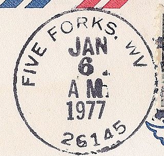
Five Forks is an unincorporated community in Calhoun County, West Virginia, United States. It lies along West Virginia Route 16 to the north of the town of Grantsville, the county seat of Calhoun County. Its elevation is 1,106 feet (337 m). The Five Forks Post Office is closed.

Cootes Store is an unincorporated community in Rockingham County, Virginia, United States. Located in the Shenandoah Valley, it is situated north of Harrisonburg, south of Bergton, and west of Timberville. The border with West Virginia is nearby, as is the edge of George Washington National Forest. Cootes Store is within a gorge where the North Fork Shenandoah River breaks, at the crossroads of Route 613 and Route 259.
Five Forks, West Virginia may refer to:

The Laurel Fork is a 15.7-mile-long (25.3 km) stream in Virginia and West Virginia, United States. The stream flows north from Highland County, Virginia, where its source and the majority of its length is located, to its mouth in Pendleton County, West Virginia. Laurel Fork is a tributary to the North Fork South Branch Potomac River, making it a part of the Potomac River watershed. The area surrounding Laurel Fork is home to several plant and animal species found nowhere else in Virginia, and is a prime example of a northern boreal forest in the state.

Ravenswood District, formerly Ravenswood Magisterial District, is one of five historic magisterial districts in Jackson County, West Virginia, United States. The district was originally known as Gilmore Township, one of five civil townships established in 1863; the name officially became "Ravenswood" in 1871, and Jackson County's townships were converted into magisterial districts in 1872. When Jackson County was redistricted in the 1990s, the area of Ravenswood District was divided between the new Northern and Western Magisterial Districts. However, the county's historic magisterial districts continue to exist in the form of tax districts, serving all of their former administrative functions except for the election of county officials.

Ripley District, formerly Ripley Magisterial District, is one of five historic magisterial districts in Jackson County, West Virginia, United States. The district was originally known as Mill Creek Township, one of five civil townships established in Jackson County after West Virginia became a state in 1863; it was renamed "Ripley Township" after its chief town in 1871, and the following year, all of West Virginia's townships were converted into magisterial districts. When Jackson County was redistricted in the 1990s, the area of Ripley District was divided between the new Eastern and Western Magisterial Districts. However, the county's historic magisterial districts continue to exist in the form of tax districts, serving all of their former administrative functions except for the election of county officials.
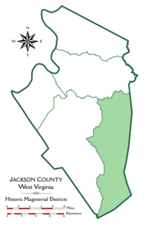
Washington District, formerly Washington Magisterial District, is one of five historic magisterial districts in Jackson County, West Virginia, United States. The district was originally established as one of five civil townships in Jackson County after West Virginia became a state in 1863; in 1872, all of West Virginia's townships were converted into magisterial districts. When Jackson County was redistricted in the 1990s, Washington District was combined with the eastern portion of Ripley District, including the city of Ripley, to form the new Eastern Magisterial District. However, the county's historic magisterial districts continue to exist in the form of tax districts, serving all of their former administrative functions except for the election of county officials.

The Eastern Magisterial District is one of three magisterial districts in Jackson County, West Virginia, United States. It was established during a process of redistricting undertaken in the 1990s. In 2010, 9,882 people lived in the district.


