Nicholas County, West Virginia

Last updated

Nicholas County
Nicholas County Courthouse Summersville.jpg
The Nicholas County Courthouse in Summersville in 2007
Seal of Nicholas County, West Virginia.svg
Map of West Virginia highlighting Nicholas County.svg
Location within the U.S. state of West Virginia
West Virginia in United States.svg
West Virginia's location within the U.S.
Coordinates: 38°17′N80°48′W / 38.29°N 80.8°W / 38.29; -80.8
CountryFlag of the United States.svg United States
StateFlag of West Virginia.svg  West Virginia
FoundedJanuary 30, 1818
Named for Wilson Cary Nicholas
Seat Summersville
Largest citySummersville
Area
  Total654 sq mi (1,690 km2)
  Land647 sq mi (1,680 km2)
  Water7.6 sq mi (20 km2)  1.2%
Population
 (2020)
  Total24,604
  Estimate 
(2021)
24,300 Decrease2.svg
  Density38/sq mi (15/km2)
Time zone UTC−5 (Eastern)
  Summer (DST) UTC−4 (EDT)
Congressional district 1st
Website www.nicholascountywv.org
One of several markers designating the border between Nicholas and Greenbrier counties along Greenbrier Road near Richwood. Older stone survey markers are located a few feet behind the modern highway sign. NicholasCountySignWV.jpg
One of several markers designating the border between Nicholas and Greenbrier counties along Greenbrier Road near Richwood. Older stone survey markers are located a few feet behind the modern highway sign.

Nicholas County is a county located in the central region of U.S. state of West Virginia. As of the 2020 census, the population was 24,604. [1] Its county seat is Summersville. [2] The county was created in 1818 by the Virginia General Assembly and named for Virginia Governor Wilson Cary Nicholas. [3]

Contents

Geography

According to the United States Census Bureau, the county has a total area of 654 square miles (1,690 km2), of which 647 square miles (1,680 km2) is land and 7.6 square miles (20 km2) (1.2%) is water. [4]

In 1863, West Virginia's counties were divided into civil townships, with the intention of encouraging local government. This proved impractical in the heavily rural state, and in 1872 the townships were converted into magisterial districts. [5] Nicholas County was divided into six districts: Grant, Jefferson, Kentucky, Mumble-the-peg, Summersville, and Wilderness. In 1873, Mumble-the-peg became Hamilton District. A seventh district, Beaver, was created in the 1880s. [6]

Major highways

Battlefields

Carnifex Ferry Battlefield, Keslers Cross Lanes

Adjacent counties

National protected areas

Demographics

Historical population
CensusPop.Note
1820 1,853
1830 3,34680.6%
1840 2,515−24.8%
1850 3,96357.6%
1860 4,62716.8%
1870 4,458−3.7%
1880 7,22362.0%
1890 9,30928.9%
1900 11,40322.5%
1910 17,69955.2%
1920 20,71717.1%
1930 20,686−0.1%
1940 24,07016.4%
1950 27,69615.1%
1960 25,414−8.2%
1970 22,552−11.3%
1980 28,12624.7%
1990 26,775−4.8%
2000 26,562−0.8%
2010 26,233−1.2%
2020 24,604−6.2%
2021 (est.)24,300 [7] −1.2%
U.S. Decennial Census [8]
1790–1960 [9] 1900–1990 [10]
1990–2000 [11] 2010–2020 [1]

2000 census

As of the census of 2000, there were 26,562 people, 10,722 households, and 7,762 families living in the county. The population density was 41 people per square mile (16 people/km2). There were 12,406 housing units at an average density of 19 units per square mile (7.3 units/km2). The racial makeup of the county was 98.84% White, 0.05% Black or African American, 0.24% Native American, 0.19% Asian, 0.02% Pacific Islander, 0.10% from other races, and 0.55% from two or more races. 0.48% of the population were Hispanic or Latino of any race.

There were 10,722 households, out of which 30.70% had children under the age of 18 living with them, 58.70% were married couples living together, 10.00% had a female householder with no husband present, and 27.60% were non-families. 24.80% of all households were made up of individuals, and 11.80% had someone living alone who was 65 years of age or older. The average household size was 2.46 and the average family size was 2.91.

In the county, the population was spread out, with 23.30% under the age of 18, 8.10% from 18 to 24, 27.60% from 25 to 44, 26.00% from 45 to 64, and 15.00% who were 65 years of age or older. The median age was 39 years. For every 100 females there were 95.60 males. For every 100 females age 18 and over, there were 92.20 males.

The median income for a household in the county was $26,974, and the median income for a family was $32,074. Males had a median income of $30,508 versus $17,964 for females. The per capita income for the county was $15,207. About 15.00% of families and 19.20% of the population were below the poverty line, including 25.40% of those under age 18 and 13.80% of those age 65 or over.

2010 census

As of the 2010 United States census, there were 26,233 people, 10,938 households, and 7,591 families living in the county. [12] The population density was 40.6 inhabitants per square mile (15.7/km2). There were 13,064 housing units at an average density of 20.2 units per square mile (7.8 units/km2). [13] The racial makeup of the county was 98.4% white, 0.3% Asian, 0.2% American Indian, 0.2% black or African American, 0.1% from other races, and 0.9% from two or more races. Those of Hispanic or Latino origin made up 0.6% of the population. [12] In terms of ancestry, 21.7% were Irish, 19.0% were German, 12.9% were English, and 10.1% were American. [14]

Of the 10,938 households, 28.8% had children under the age of 18 living with them, 53.8% were married couples living together, 10.7% had a female householder with no husband present, 30.6% were non-families, and 26.5% of all households were made up of individuals. The average household size was 2.38 and the average family size was 2.85. The median age was 43.3 years. [12]

The median income for a household in the county was $38,457 and the median income for a family was $45,127. Males had a median income of $42,302 versus $25,859 for females. The per capita income for the county was $19,359. About 14.3% of families and 18.7% of the population were below the poverty line, including 25.5% of those under age 18 and 12.3% of those age 65 or over. [15]

Politics

United States presidential election results for Nicholas County, West Virginia [16]
Year Republican Democratic Third party
No.%No.%No.%
2020 8,27977.86%2,22620.93%1281.20%
2016 7,25175.70%1,84019.21%4885.09%
2012 5,89867.09%2,66430.30%2292.60%
2008 4,80451.32%4,35746.54%2002.14%
2004 5,48552.99%4,78846.26%780.75%
2000 4,35950.81%4,05947.31%1611.88%
1996 2,64931.03%4,76955.87%1,11813.10%
1992 2,95931.05%5,04252.91%1,52816.04%
1988 3,73141.75%5,17357.89%320.36%
1984 4,65650.21%4,58849.48%290.31%
1980 3,88540.83%5,26555.33%3663.85%
1976 3,46235.70%6,23564.30%00.00%
1972 5,90761.95%3,62838.05%00.00%
1968 3,67839.22%4,85851.81%8418.97%
1964 2,62827.65%6,87872.35%00.00%
1960 4,29742.67%5,77457.33%00.00%
1956 5,26351.89%4,88048.11%00.00%
1952 4,38643.86%5,61556.14%00.00%
1948 3,39140.22%5,01859.51%230.27%
1944 3,25943.09%4,30556.91%00.00%
1940 4,29944.73%5,31255.27%00.00%
1936 3,96440.02%5,87259.28%700.71%
1932 3,68440.50%5,32758.56%860.95%
1928 3,91752.36%3,49546.72%690.92%
1924 3,34745.02%3,95653.21%1311.76%
1920 3,69150.53%3,56448.79%500.68%
1916 2,05644.77%2,46753.72%691.50%
1912 58414.40%2,01849.75%1,45435.85%

Elected officials

[17]

PositionElected Official
Nicholas County Commission
  • Garrett Cole, President
  • Lloyd Adkins
  • D. Craig Chapman
Nicholas County AssessorErnie Dennison
Nicholas County Circuit ClerkDebbie Facemire
Nicholas County ClerkRobert Painter
Nicholas County ProsecutorJonathan Sweeney
Nicholas County SheriffWilliam Nunley

Communities

Cities

Magisterial districts

Census-designated places

Unincorporated communities

See also

Related Research Articles

<span class="mw-page-title-main">Braxton County, West Virginia</span> County in West Virginia, United States

Braxton County is a county in the central part of the U.S. state of West Virginia. As of the 2020 census, the population was 12,447. The county seat is Sutton. The county was formed in 1836 from parts of Lewis, Kanawha, and Nicholas counties and named for Carter Braxton, a Virginia statesman and signer of the Declaration of Independence.

<span class="mw-page-title-main">Wetzel County, West Virginia</span> County in West Virginia, United States

Wetzel County is a county in the U.S. state of West Virginia. As of the 2020 census, the population was 14,442. Its county seat is New Martinsville. The county, founded in 1846, is named for Lewis Wetzel, a famous frontiersman and Indian fighter. Its northern border aligns with the Mason-Dixon line, but is to the west of the line's western terminus.

<span class="mw-page-title-main">Webster County, West Virginia</span> County in West Virginia, United States

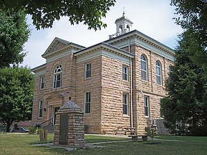
Webster County is a county in the U.S. state of West Virginia. As of the 2020 census, the population was 8,378. Its county seat is Webster Springs. The county was founded in 1860 and named for Daniel Webster.

<span class="mw-page-title-main">Tyler County, West Virginia</span> County in West Virginia, United States

Tyler County is a county in the U.S. state of West Virginia. As of the 2020 census, the population was 8,313. Its county seat is Middlebourne. The county was founded in 1814 and is named after John Tyler, Sr., father of President John Tyler.

<span class="mw-page-title-main">Taylor County, West Virginia</span> County in West Virginia, United States

Taylor County is a county in the U.S. state of West Virginia. As of the 2020 census, the population was 16,705. Its county seat is Grafton. The county was formed in 1844 and named for Senator John Taylor of Caroline.

<span class="mw-page-title-main">Monongalia County, West Virginia</span> County in West Virginia, United States

Monongalia County, known locally as Mon County, is located in the U.S. state of West Virginia. As of the 2020 census, the population was 105,822, making it West Virginia's third-most populous county. Its county seat is Morgantown. The county was founded in 1776. Monongalia County is included in the Morgantown, WV Metropolitan Statistical Area, and is the largest county in North-Central West Virginia. It is part of the Pittsburgh media market.

<span class="mw-page-title-main">Hancock County, West Virginia</span> County in West Virginia, United States

Hancock County is a county in the U.S. state of West Virginia. As of the 2020 census, the population was 29,095. Its county seat is New Cumberland and its largest city is Weirton. The county was created from Brooke County in 1848 and named for John Hancock, first signer of the Declaration of Independence. Located at the tip of the state's Northern Panhandle, Hancock County is the northernmost point in both West Virginia and, by some definitions, the Southern United States. Hancock County is part of the Weirton-Steubenville, WV-OH Metropolitan Statistical Area, which is also included in the Pittsburgh-New Castle-Weirton, PA-WV-OH Combined Statistical Area.

<span class="mw-page-title-main">Hedgesville, West Virginia</span> Town in West Virginia, United States

Hedgesville is a town in Berkeley County, West Virginia, United States, in the state's Eastern Panhandle region. The population was 318 at the 2010 census. The town sits on WV 9, roughly 13 miles east of Berkeley Springs. In addition to its legal definition, Hedgesville has come to be the common name for the large and sparsely inhabited area of West Virginia's Eastern Panhandle bordered by the Potomac River to the North and East, a southern border defined roughly by an imaginary line from the city of Martinsburg to the tip of Virginia, and Berkeley Springs to the West.

<span class="mw-page-title-main">Gauley Bridge, West Virginia</span> Town in West Virginia, United States

Gauley Bridge is a town in Fayette County, West Virginia, United States. The population was 614 at the 2010 census. The Kanawha River is formed at Gauley Bridge by the confluence of the New and Gauley Rivers. Two miles to the southwest of Gauley Bridge, in Glen Ferris, is Kanawha Falls, a popular stopping point on Midland Trail Scenic Highway.

<span class="mw-page-title-main">Lost Creek, West Virginia</span> Town in West Virginia, United States

Lost Creek is a town in Harrison County, West Virginia, United States. The population was 359 at the 2020 census.

<span class="mw-page-title-main">West Milford, West Virginia</span> Town in West Virginia, United States

West Milford is a town in Harrison County, West Virginia, United States. The population was 452 at the 2020 census.

<span class="mw-page-title-main">Bradshaw, West Virginia</span> Town in West Virginia, United States

Bradshaw is a town in McDowell County, West Virginia, United States. The population was 337 at the 2010 census. Bradshaw was incorporated in December 1979 and named for a pioneer settler.

<span class="mw-page-title-main">Peterstown, West Virginia</span> Town in West Virginia, United States

Peterstown is a town in Monroe County, West Virginia, United States. The population was 456 at the 2020 census.

<span class="mw-page-title-main">Richwood, West Virginia</span> City in West Virginia, United States

Richwood is a city in Nicholas County, West Virginia, United States. In 2020, the census showed Richwood with a population of 1,661. During the 19th and early 20th century Richwood was a booming coal and lumber town. Richwood has a very rich history, including the formation of the Cherry River Navy civic organization to draw attention to issues important to the community. Richwood has also become known statewide as the "Ramp Capital of the World". Each year, in April, the city hosts a large festival that draws visitors from around the country.

<span class="mw-page-title-main">Summersville, West Virginia</span> City in West Virginia, United States

Summersville is a city in Nicholas County, West Virginia, United States. The population was 3,459 at the 2020 census. It is the county seat of Nicholas County.

<span class="mw-page-title-main">Pennsboro, West Virginia</span> City in West Virginia, United States

Pennsboro is a city in Ritchie County, West Virginia, United States. The population was 1,050 at the 2020 census. The city is located at the junction of U.S. Route 50 and West Virginia Route 74; the North Bend Rail Trail also passes through the city.

<span class="mw-page-title-main">Flemington, West Virginia</span> Town in West Virginia, United States

Flemington is a town in Taylor County, West Virginia, United States. The population was 311 at the 2020 census. Flemington was incorporated in 1922 by the West Virginia Circuit Court, and named for James Fleming, an early settler in the area originally from Hampshire County.

<span class="mw-page-title-main">Camden-on-Gauley, West Virginia</span> Town in West Virginia, United States

Camden-on-Gauley is a town in Webster County, West Virginia, United States, along the Gauley River. The population was 126 at the 2020 census.

<span class="mw-page-title-main">New Martinsville, West Virginia</span> City in West Virginia, United States

New Martinsville is a city in and the county seat of Wetzel County, West Virginia, United States, along the Ohio River. The population was 5,186 at the 2020 census.

<span class="mw-page-title-main">Pine Grove, West Virginia</span> Town in West Virginia, United States

Pine Grove is a town in Wetzel County, West Virginia, United States. The population was 363 at the 2020 census. The community was named for a grove of pine trees near the original town site.

References

  1. 1 2 "State & County QuickFacts". United States Census Bureau. Retrieved October 18, 2022.
  2. "Find a County". National Association of Counties. Retrieved June 7, 2011.
  3. "Nicholas County history sources". Archived from the original on January 23, 2013. Retrieved January 29, 2013.
  4. "2010 Census Gazetteer Files". United States Census Bureau. August 22, 2012. Retrieved July 30, 2015.
  5. Otis K. Rice & Stephen W. Brown, West Virginia: A History, 2nd ed., University Press of Kentucky, Lexington (1993), p. 240.
  6. United States Census Bureau, U.S. Decennial Census, Tables of Minor Civil Divisions in West Virginia, 1870–2010.
  7. "Annual Estimates of the Resident Population for Counties: April 1, 2020 to July 1, 2021" . Retrieved October 18, 2022.
  8. "U.S. Decennial Census". United States Census Bureau. Retrieved January 10, 2014.
  9. "Historical Census Browser". University of Virginia Library. Retrieved January 10, 2014.
  10. "Population of Counties by Decennial Census: 1900 to 1990". United States Census Bureau. Retrieved January 10, 2014.
  11. "Census 2000 PHC-T-4. Ranking Tables for Counties: 1990 and 2000" (PDF). United States Census Bureau. Archived (PDF) from the original on October 9, 2022. Retrieved January 10, 2014.
  12. 1 2 3 "DP-1 Profile of General Population and Housing Characteristics: 2010 Demographic Profile Data". United States Census Bureau. Archived from the original on February 13, 2020. Retrieved April 3, 2016.
  13. "Population, Housing Units, Area, and Density: 2010 - County". United States Census Bureau. Archived from the original on February 13, 2020. Retrieved April 3, 2016.
  14. "DP02 SELECTED SOCIAL CHARACTERISTICS IN THE UNITED STATES – 2006-2010 American Community Survey 5-Year Estimates". United States Census Bureau. Archived from the original on February 13, 2020. Retrieved April 3, 2016.
  15. "DP03 SELECTED ECONOMIC CHARACTERISTICS – 2006-2010 American Community Survey 5-Year Estimates". United States Census Bureau. Archived from the original on February 13, 2020. Retrieved April 3, 2016.
  16. Leip, David. "Dave Leip's Atlas of U.S. Presidential Elections". uselectionatlas.org. Retrieved March 28, 2018.
  17. "County Offices".

Further reading

38°17′N80°48′W / 38.29°N 80.80°W / 38.29; -80.80