Tyler County, West Virginia

Last updated

Tyler County
Tyler County Courthouse WV.jpg
Tyler County Courthouse in Middlebourne
Map of West Virginia highlighting Tyler County.svg
Location within the U.S. state of West Virginia
West Virginia in United States.svg
West Virginia's location within the U.S.
Coordinates: 39°28′N80°53′W / 39.47°N 80.88°W / 39.47; -80.88
CountryFlag of the United States.svg United States
StateFlag of West Virginia.svg  West Virginia
FoundedDecember 6, 1814
Named for John Tyler Sr.
Seat Middlebourne
Largest city Paden City
Area
  Total261 sq mi (680 km2)
  Land256 sq mi (660 km2)
  Water4.4 sq mi (11 km2)  1.7%
Population
 (2020)
  Total8,313
  Estimate 
(2021)
8,155 Decrease2.svg
  Density32/sq mi (12/km2)
Time zone UTC−5 (Eastern)
  Summer (DST) UTC−4 (EDT)
Congressional district 1st
Website www.tylercountywv.com

Tyler County is a county in the U.S. state of West Virginia. As of the 2020 census, the population was 8,313. [1] Its county seat is Middlebourne. [2] The county was founded in 1814 and is named after John Tyler, Sr., father of President John Tyler. [3]

Contents

History

The earliest white hunters (mainly of Scotch-Irish, English, and German descent) settled in what later became Tyler County in 1792 near the present town of Friendly. This area on the banks of the Ohio River was former Indian hunting grounds.

Tyler County was officially formed from a portion of what was then Ohio County, Virginia, on December 6, 1814. The following year, Middlebourne (founded 1798) became the county seat. This vast area was diminished over the years: in 1845 a small portion went the newly established Doddridge County; in 1846 the northern half went to make up the new Wetzel County; and in 1851 the southern third went to Pleasants County. [4]

On June 20, 1863, at the height of the Civil War, Tyler was one of fifty Virginia counties that entered the Union as the state of West Virginia. Later that year, the counties were divided into civil townships, with the intention of encouraging local government. This proved impractical in the heavily rural state, and in 1872 the townships were converted into magisterial districts. [5] Tyler County was divided into six districts: Centreville, [lower-roman 1] Ellsworth, Lincoln, McElroy, Meade, and Union. Except for minor adjustments, these districts were largely unchanged until the 1980s, when they were consolidated into four new magisterial districts: Central, North, South, and West. [6] The names and boundaries of the historic magisterial districts continued to exist in the form of tax and assessment districts. [7]

Geography

According to the United States Census Bureau, the county has a total area of 261 square miles (680 km2), of which 256 square miles (660 km2) is land and 4.4 square miles (11 km2) (1.7%) is water. [8]

Major highways

Adjacent counties

National protected area

Demographics

Historical population
CensusPop.Note
1820 2,314
1830 4,10477.4%
1840 6,95469.4%
1850 5,498−20.9%
1860 6,51718.5%
1870 7,83220.2%
1880 11,07341.4%
1890 11,9628.0%
1900 18,25252.6%
1910 16,211−11.2%
1920 14,186−12.5%
1930 12,785−9.9%
1940 12,559−1.8%
1950 10,535−16.1%
1960 10,026−4.8%
1970 9,929−1.0%
1980 11,32014.0%
1990 9,796−13.5%
2000 9,592−2.1%
2010 9,208−4.0%
2020 8,313−9.7%
2021 (est.)8,155 [9] −1.9%
U.S. Decennial Census [10]
1790–1960 [11] 1900–1990 [12]
1990–2000 [13] 2010–2020 [1]

2020 census

As of the 2020 census, there were 8,313 people and 2,894 households residing in the county. There were 4,119 housing units in Tyler. The racial makeup of the county was 96% White, 0.2% Native American, 0.04% African American, 0.03% Asian, 0.2% from other races, and 3.5% from two or more races. Hispanics or Latinos of any race were 0.6% of the population.

Of the 2,894 households, 50.1% were married couples living together, 27.1% had a female householder with no spouse present, 17.6% had a male householder with no spouse present. The average household and family size was 3.75. The median age in the county was 48.1 years with 19.5% of the population under 18. The median income for a household was $50,601 and the poverty rate was 12%. [14]

2000 census

As of the census of 2000, there were 9,592 people, 3,836 households, and 2,834 families living in the county. The population density was 37 people per square mile (14 people/km2). There were 4,780 housing units at an average density of 19 units per square mile (7.3 units/km2). The racial makeup of the county was 99.35% White, 0.02% Black or African American, 0.05% Native American, 0.08% Asian, 0.01% Pacific Islander, 0.03% from other races, and 0.45% from two or more races. 0.43% of the population were Hispanic or Latino of any race.

There were 3,836 households, out of which 30.30% had children under the age of 18 living with them, 61.40% were married couples living together, 8.60% had a female householder with no husband present, and 26.10% were non-families. 23.10% of all households were made up of individuals, and 12.10% had someone living alone who was 65 years of age or older. The average household size was 2.47 and the average family size was 2.89.

In the county, the population was spread out, with 23.30% under the age of 18, 6.50% from 18 to 24, 26.90% from 25 to 44, 26.90% from 45 to 64, and 16.50% who were 65 years of age or older. The median age was 41 years. For every 100 females there were 95.50 males. For every 100 females age 18 and over, there were 94.90 males.

The median income for a household in the county was $29,290, and the median income for a family was $35,320. Males had a median income of $34,250 versus $18,140 for females. The per capita income for the county was $15,216. About 12.20% of families and 16.60% of the population were below the poverty line, including 24.00% of those under age 18 and 12.70% of those age 65 or over.

2010 census

As of the 2010 United States census, there were 9,208 people, 3,858 households, and 2,638 families living in the county. [15] The population density was 35.9 inhabitants per square mile (13.9/km2). There were 5,000 housing units at an average density of 19.5 units per square mile (7.5 units/km2). [16] The racial makeup of the county was 99.0% white, 0.2% American Indian, 0.2% black or African American, 0.1% Asian, 0.0% from other races, and 0.5% from two or more races. Those of Hispanic or Latino origin made up 0.5% of the population. [15] In terms of ancestry, 23.3% were German, 16.1% were English, 12.7% were Irish, and 11.8% were American. [17]

Of the 3,858 households, 27.8% had children under the age of 18 living with them, 55.2% were married couples living together, 8.7% had a female householder with no husband present, 31.6% were non-families, and 27.2% of all households were made up of individuals. The average household size was 2.37 and the average family size was 2.84. The median age was 45.2 years. [15]

The median income for a household in the county was $33,496 and the median income for a family was $42,209. Males had a median income of $37,414 versus $25,335 for females. The per capita income for the county was $18,245. About 12.9% of families and 18.1% of the population were below the poverty line, including 25.0% of those under age 18 and 9.8% of those age 65 or over. [18]

Politics

After having leaned strongly towards the Democratic Party between the New Deal and Bill Clinton's presidency, most of West Virginia has since 2000 seen an extremely rapid swing towards the Republican Party due to declining unionization. [19] In contrast, Tyler County, along with neighboring Doddridge County and Ritchie County were historically powerfully Unionist and have been rock-ribbed Republican since the Civil War. The only Democratic presidential candidates to have won Tyler County since West Virginia's statehood are Woodrow Wilson in 1912, who won by just 64 votes, and Bill Clinton in 1996. [20]

United States presidential election results for Tyler County, West Virginia [21]
Year Republican Democratic Third party
No.%No.%No.%
2020 3,22682.23%63116.08%661.68%
2016 2,99681.15%50713.73%1895.12%
2012 2,31470.44%89027.09%812.47%
2008 2,41564.55%1,24133.17%852.27%
2004 2,79865.91%1,40133.00%461.08%
2000 2,58265.73%1,21430.91%1323.36%
1996 73426.40%1,45952.48%58721.12%
1992 1,59337.90%1,58737.76%1,02324.34%
1988 2,36561.05%1,50138.75%80.21%
1984 3,17069.29%1,39530.49%100.22%
1980 2,70761.78%1,48233.82%1934.40%
1976 2,51458.05%1,81741.95%00.00%
1972 3,36274.93%1,12525.07%00.00%
1968 2,89763.90%1,32429.20%3136.90%
1964 2,52252.57%2,27547.43%00.00%
1960 3,53769.42%1,55830.58%00.00%
1956 3,67173.58%1,31826.42%00.00%
1952 3,48869.61%1,52330.39%00.00%
1948 3,16066.48%1,57933.22%140.29%
1944 3,42970.60%1,42829.40%00.00%
1940 4,35468.24%2,02631.76%00.00%
1936 4,03161.46%2,50938.25%190.29%
1932 3,73458.44%2,58240.41%741.16%
1928 3,88170.14%1,59128.75%611.10%
1924 3,42560.38%2,13737.68%1101.94%
1920 3,65466.33%1,76231.98%931.69%
1916 1,90057.51%1,33640.44%682.06%
1912 70622.08%1,19337.30%1,29940.62%

Attractions

Festivals

Historical

Natural

Other attractions

Communities

Magisterial districts

Current

  • Central
  • North
  • South
  • West

Historic

  • Centreville
  • Ellsworth
  • Lincoln
  • McElroy
  • Meade
  • Union

Cities, Towns, and Villages

Unincorporated Communities

A
B
C
D
E
F
I
J
K
L
M
P
S
T
V
W

Notable people

See also

Notes

  1. Also spelled "Centerville" in early records.

Related Research Articles

<span class="mw-page-title-main">Clay County, West Virginia</span> County in West Virginia, United States

Clay County is a county in the U.S. state of West Virginia. As of the 2020 census, the population was 8,051. Its county seat is Clay. The county was founded in 1858 and named in honor of Henry Clay, famous American statesman, member of the United States Senate from Kentucky and United States Secretary of State in the 19th century.

<span class="mw-page-title-main">Wellsburg, West Virginia</span> City in West Virginia, United States

Wellsburg is a city in and the county seat of Brooke County, West Virginia, United States. The 2020 census recorded a population of 2,455. It is a part of the Weirton–Steubenville metropolitan area. The city's economy includes several telemarketing facilities, and a factory that does metal fabrication and plastics molding.

<span class="mw-page-title-main">Braxton County, West Virginia</span> County in West Virginia, United States

Braxton County is a county in the central part of the U.S. state of West Virginia. As of the 2020 census, the population was 12,447. The county seat is Sutton. The county was formed in 1836 from parts of Lewis, Kanawha, and Nicholas counties and named for Carter Braxton, a Virginia statesman and signer of the Declaration of Independence.

<span class="mw-page-title-main">Wirt County, West Virginia</span> County in West Virginia, United States

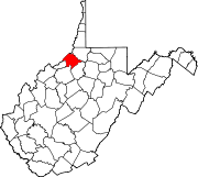
Wirt County is a county in the U.S. state of West Virginia. As of the 2020 census, the population was 5,194, making it the least populous county in West Virginia. Its county seat is Elizabeth. The county was created in 1848 by the Virginia General Assembly and named for U.S. Attorney General and presidential candidate William Wirt. The county is served by one high school, Wirt County High School.

<span class="mw-page-title-main">Wetzel County, West Virginia</span> County in West Virginia, United States

Wetzel County is a county in the U.S. state of West Virginia. As of the 2020 census, the population was 14,442. Its county seat is New Martinsville. The county, founded in 1846, is named for Lewis Wetzel, a famous frontiersman and Indian fighter. Its northern border aligns with the Mason-Dixon line, but is to the west of the line's western terminus.

<span class="mw-page-title-main">Webster County, West Virginia</span> County in West Virginia, United States

Webster County is a county in the U.S. state of West Virginia. As of the 2020 census, the population was 8,378. Its county seat is Webster Springs. The county was founded in 1860 and named for Daniel Webster.

<span class="mw-page-title-main">Ritchie County, West Virginia</span> County in West Virginia, United States

Ritchie County is a county in the U.S. state of West Virginia. As of the 2020 census, the population was 8,444. Its county seat is Harrisville. The county was created in 1843 by the Virginia General Assembly and named for Richmond newspaper publisher Thomas Ritchie.

<span class="mw-page-title-main">Pleasants County, West Virginia</span> County in West Virginia, United States

Pleasants County is a county located in the U.S. state of West Virginia. At the 2020 census, the population was 7,653. Its county seat is St. Marys.

<span class="mw-page-title-main">Nicholas County, West Virginia</span> County in West Virginia, United States

Nicholas County is a county located in the central region of U.S. state of West Virginia. As of the 2020 census, the population was 24,604. Its county seat is Summersville. The county was created in 1818 by the Virginia General Assembly and named for Virginia Governor Wilson Cary Nicholas.

<span class="mw-page-title-main">Logan County, West Virginia</span> County in West Virginia, United States

Logan County is a county in the U.S. state of West Virginia. As of the 2020 census, the population was 32,567. Its county seat is Logan. Logan County comprises the Logan, WV Micropolitan Statistical Area, which is also included in the Charleston–Huntington–Ashland, WV–OH–KY Combined Statistical Area.

<span class="mw-page-title-main">Lincoln County, West Virginia</span> County in West Virginia, United States

Lincoln County is a county in the U.S. state of West Virginia. As of the 2020 census, the population was 20,463. Its county seat is Hamlin. The county was created in 1867 and named for Abraham Lincoln.

<span class="mw-page-title-main">Kanawha County, West Virginia</span> County in West Virginia, United States

Kanawha County is a county in the U.S. state of West Virginia. As of the 2020 census, the population was 180,745, making it West Virginia's most populous county. The county seat is Charleston, which is also the state capital and most populous city. Kanawha County is part of the Charleston, WV Metropolitan Statistical Area.

<span class="mw-page-title-main">Harrison County, West Virginia</span> County in West Virginia, United States

Harrison County is a county in the U.S. state of West Virginia. As of the 2020 census, the population was 65,921. Its county seat is Clarksburg.

<span class="mw-page-title-main">Doddridge County, West Virginia</span> County in West Virginia, United States

Doddridge County is a county in the U.S. state of West Virginia. As of the 2020 census, the population was 7,808. Its county seat is West Union.

<span class="mw-page-title-main">Calhoun County, West Virginia</span> County in West Virginia, United States

Calhoun County is a county in the U.S. state of West Virginia. As of the 2020 census, the population was 6,229, making it the third-least populous county in West Virginia. Its county seat is Grantsville. The county was founded in 1856 and named for South Carolina politician John C. Calhoun.

<span class="mw-page-title-main">Durbin, West Virginia</span> Town in West Virginia, United States

Durbin is a town in Pocahontas County, West Virginia, United States. The population was 235 at the 2020 census.

<span class="mw-page-title-main">Friendly, West Virginia</span> Town in West Virginia, United States

Friendly is a town in Tyler County, West Virginia, United States. The population was 100 at the 2020 census.

<span class="mw-page-title-main">Middlebourne, West Virginia</span> Town in West Virginia, United States

Middlebourne is a town and the county seat of Tyler County, West Virginia, United States. The population was 715 at the 2020 census.

<span class="mw-page-title-main">Sistersville, West Virginia</span> City in West Virginia, United States

Sistersville is a city in Tyler County, West Virginia, United States, along the Ohio River. The population was 1,413 at the 2020 census. The Sistersville Ferry crosses the Ohio River to the unincorporated community of Fly in Monroe County, Ohio.

<span class="mw-page-title-main">Paden City, West Virginia</span> City in West Virginia, United States

Paden City is a city in Tyler and Wetzel counties in the U.S. state of West Virginia, along the Ohio River. It was founded in 1902. The population was 2,550 at the 2020 census.

References

  1. 1 2 "State & County QuickFacts". United States Census Bureau. Retrieved October 20, 2022.
  2. "Find a County". National Association of Counties. Retrieved June 7, 2011.
  3. "Tyler County history sources". Archived from the original on May 29, 2013. Retrieved January 29, 2013.
  4. History of County Formations in Virginia 1617-1995
  5. Otis K. Rice & Stephen W. Brown, West Virginia: A History, 2nd ed., University Press of Kentucky, Lexington (1993), p. 240.
  6. United States Census Bureau, U.S. Decennial Census, Tables of Minor Civil Divisions in West Virginia, 1870–2010.
  7. West Virginia List of Districts by County, accessed February 2018.
  8. "2010 Census Gazetteer Files". United States Census Bureau. August 22, 2012. Retrieved July 31, 2015.
  9. "Annual Estimates of the Resident Population for Counties: April 1, 2020 to July 1, 2021" . Retrieved October 20, 2022.
  10. "U.S. Decennial Census". United States Census Bureau. Retrieved January 16, 2014.
  11. "Historical Census Browser". University of Virginia Library. Retrieved January 16, 2014.
  12. "Population of Counties by Decennial Census: 1900 to 1990". United States Census Bureau. Retrieved January 16, 2014.
  13. "Census 2000 PHC-T-4. Ranking Tables for Counties: 1990 and 2000" (PDF). United States Census Bureau. Archived (PDF) from the original on October 9, 2022. Retrieved January 16, 2014.
  14. "Explore Census Data".
  15. 1 2 3 "DP-1 Profile of General Population and Housing Characteristics: 2010 Demographic Profile Data". United States Census Bureau. Archived from the original on February 13, 2020. Retrieved April 3, 2016.
  16. "Population, Housing Units, Area, and Density: 2010 - County". United States Census Bureau. Archived from the original on February 13, 2020. Retrieved April 3, 2016.
  17. "DP02 SELECTED SOCIAL CHARACTERISTICS IN THE UNITED STATES – 2006-2010 American Community Survey 5-Year Estimates". United States Census Bureau. Archived from the original on February 13, 2020. Retrieved April 3, 2016.
  18. "DP03 SELECTED ECONOMIC CHARACTERISTICS – 2006-2010 American Community Survey 5-Year Estimates". United States Census Bureau. Archived from the original on February 13, 2020. Retrieved April 3, 2016.
  19. Schwartzman, Gabe; 'How Central Appalachia Went Right'
  20. "Presidential Election of 1912 – Map by Counties (.xlsx file for €15)". Géoelections. Archived from the original on June 13, 2018. Retrieved June 6, 2017.
  21. Leip, David. "Dave Leip's Atlas of U.S. Presidential Elections". uselectionatlas.org. Retrieved March 28, 2018.
  22. "Tyler County". The West Virginia Encyclopedia. West Virginia Humanities Council. Retrieved September 18, 2014.
  23. "Arthur Ingraham Boreman". The West Virginia Encyclopedia. West Virginia Humanities Council. Retrieved September 18, 2014.
  24. "Cecil Underwood". The West Virginia Encyclopedia. West Virginia Humanities Council. Retrieved September 18, 2014.

39°28′N80°53′W / 39.47°N 80.88°W / 39.47; -80.88