Clay County, West Virginia

Last updated

Clay County
Clay County Courthouse West Virginia.jpg
The Old Clay County Courthouse in Clay in 2007
Seal of Clay County, West Virginia.png
Map of West Virginia highlighting Clay County.svg
Location within the U.S. state of West Virginia
West Virginia in United States.svg
West Virginia's location within the U.S.
Coordinates: 38°28′N81°04′W / 38.46°N 81.07°W / 38.46; -81.07
CountryFlag of the United States.svg United States
StateFlag of West Virginia.svg  West Virginia
FoundedMarch 29, 1858
Named for Henry Clay
Seat Clay
Largest townClay
Area
  Total344 sq mi (890 km2)
  Land342 sq mi (890 km2)
  Water1.9 sq mi (5 km2)  0.5%
Population
 (2020)
  Total8,051
  Estimate 
(2021)
7,892 Decrease2.svg
  Density23/sq mi (9.0/km2)
Time zone UTC−5 (Eastern)
  Summer (DST) UTC−4 (EDT)
Congressional district 1st
Website www.claycountywv.us

Clay County is a county in the U.S. state of West Virginia. As of the 2020 census, the population was 8,051. [1] Its county seat is Clay. [2] The county was founded in 1858 and named in honor of Henry Clay, famous American statesman, member of the United States Senate from Kentucky and United States Secretary of State in the 19th century. [3]

Contents

Clay County is part of the Charleston, WV Metropolitan Statistical Area.

Geography

According to the United States Census Bureau, the county has a total area of 344 square miles (890 km2), of which 342 square miles (890 km2) is land and 1.9 square miles (4.9 km2) (0.6%) is water. [4]

In 1863, West Virginia's counties were divided into civil townships, with the intention of encouraging local government. This proved impractical in the heavily rural state, and in 1872 the townships were converted into magisterial districts. [5] Clay County was divided into four districts: Buffalo, Henry, Pleasant, and Union. A fifth district, Otter, was created from part of Henry in 1876. Between 1990 and 2000, these districts were consolidated into Districts A, B, and C. [6] Though it does have access to an interstate highway, the county has no traffic lights or public transportation. [7]

Major highways

Adjacent counties

Demographics

Historical population
CensusPop.Note
1860 1,787
1870 2,19622.9%
1880 3,46057.6%
1890 4,65934.7%
1900 8,24877.0%
1910 10,23324.1%
1920 11,48612.2%
1930 13,12514.3%
1940 15,20615.9%
1950 14,961−1.6%
1960 11,942−20.2%
1970 9,330−21.9%
1980 11,26520.7%
1990 9,983−11.4%
2000 10,3303.5%
2010 9,386−9.1%
2020 8,051−14.2%
2021 (est.)7,892 [8] −2.0%
U.S. Decennial Census [9]
1790–1960 [10] 1900–1990 [11]
1990–2000 [12] 2010–2020 [1]

2000 census

As of the census of 2000, there were 10,330 people, 4,020 households, and 2,942 families living in the county. The population density was 30 people per square mile (12 people/km2). There were 4,836 housing units at an average density of 14 per square mile (5.4/km2). The racial makeup of the county was 98.22% White, 0.08% Black or African American, 0.71% Native American, 0.02% Asian, 0.09% from other races, and 0.89% from two or more races. 0.41% of the population were Hispanic or Latino of any race.

There were 4,020 households, out of which 33.50% had children under the age of 18 living with them, 58.20% were married couples living together, 10.40% had a female householder with no husband present, and 26.80% were non-families. 24.30% of all households were made up of individuals, and 11.40% had someone living alone who was 65 years of age or older. The average household size was 2.55 and the average family size was 3.01.

In the county, the population was spread out, with 25.60% under the age of 18, 9.00% from 18 to 24, 27.50% from 25 to 44, 24.20% from 45 to 64, and 13.70% who were 65 years of age or older. The median age was 37 years. For every 100 females, there were 97.90 males. For every 100 females age 18 and over, there were 97.30 males.

The median income for a household in the county was $22,120, and the median income for a family was $27,137. Males had a median income of $30,161 versus $16,642 for females. The per capita income for the county was $12,021. About 24.40% of families and 27.50% of the population were below the poverty line, including 37.00% of those under age 18 and 15.00% of those age 65 or over.

2010 census

As of the 2010 United States census, there were 9,386 people, 3,728 households, and 2,566 families living in the county. [13] The population density was 27.5 inhabitants per square mile (10.6/km2). There were 4,572 housing units at an average density of 13.4 per square mile (5.2/km2). [14] The racial makeup of the county was 98.8% white, 0.2% American Indian, 0.1% black or African American, 0.1% Asian, 0.1% from other races, and 0.8% from two or more races. Those of Hispanic or Latino origin made up 0.4% of the population. [13] In terms of ancestry, 17.6% were Irish, 14.7% were English, 13.2% were German, 11.0% were American, and 5.0% were Dutch. [15]

Of the 3,728 households, 31.3% had children under the age of 18 living with them, 53.6% were married couples living together, 9.7% had a female householder with no husband present, 31.2% were non-families, and 26.2% of all households were made up of individuals. The average household size was 2.50 and the average family size was 3.00. The median age was 41.5 years. [13]

The median income for a household in the county was $30,789 and the median income for a family was $40,634. Males had a median income of $42,269 versus $24,402 for females. The per capita income for the county was $16,205. About 22.4% of families and 23.7% of the population were below the poverty line, including 29.3% of those under age 18 and 21.1% of those age 65 or over. [16]

Politics

Clay County was reliably Democratic throughout the 1900s, but it has shifted to being sharply Republican in recent years.

United States presidential election results for Clay County, West Virginia [17]
Year Republican Democratic Third party
No.%No.%No.%
2020 2,67979.61%64119.05%451.34%
2016 2,30076.79%56818.96%1274.24%
2012 1,97165.31%93130.85%1163.84%
2008 1,75553.75%1,42143.52%892.73%
2004 2,19853.98%1,83545.06%390.96%
2000 1,88752.68%1,61745.14%782.18%
1996 1,13731.79%2,07457.98%36610.23%
1992 1,25534.32%1,92852.72%47412.96%
1988 1,53640.30%2,26359.38%120.31%
1984 1,66743.91%2,11755.77%120.32%
1980 1,45238.60%2,18558.08%1253.32%
1976 1,28232.51%2,66267.49%00.00%
1972 2,16854.23%1,83045.77%00.00%
1968 1,47439.42%1,91651.24%3499.33%
1964 1,36630.04%3,18269.96%00.00%
1960 2,40645.70%2,85954.30%00.00%
1956 2,82051.76%2,62848.24%00.00%
1952 2,53447.38%2,81452.62%00.00%
1948 2,36644.21%2,97855.64%80.15%
1944 2,11446.88%2,39553.12%00.00%
1940 2,88145.26%3,48554.74%00.00%
1936 2,51342.56%3,38757.36%50.08%
1932 2,44344.43%3,03855.25%180.33%
1928 2,55156.76%1,92942.92%140.31%
1924 1,84347.02%2,03751.96%401.02%
1920 1,98156.37%1,53343.63%00.00%
1916 1,02148.76%1,04750.00%261.24%
1912 35216.72%93244.28%82139.00%

Clay County is also the birthplace of the Golden Delicious Apple. The original tree was found on the Mullins' family farm in Clay County, West Virginia, United States and was locally known as Mullin's Yellow Seedling and Annit apple.[ citation needed ]

See also

Related Research Articles

<span class="mw-page-title-main">Adams County, Nebraska</span> County in Nebraska, United States

Adams County is a county located in the U.S. state of Nebraska. As of the 2020 United States Census, the population was 31,205. Its county seat is Hastings. The county was formed in 1867 and organized in 1871. It is named for John Adams, the second President of the United States.

<span class="mw-page-title-main">Braxton County, West Virginia</span> County in West Virginia, United States

Braxton County is a county in the central part of the U.S. state of West Virginia. As of the 2020 census, the population was 12,447. The county seat is Sutton. The county was formed in 1836 from parts of Lewis, Kanawha, and Nicholas counties and named for Carter Braxton, a Virginia statesman and signer of the Declaration of Independence.

<span class="mw-page-title-main">Wood County, West Virginia</span> County in West Virginia, United States

Wood County is a county in the U.S. state of West Virginia. As of the 2020 census, the population was 84,296, making it West Virginia's fifth-most populous county. Its county seat is Parkersburg. The county was formed in 1798 from the western part of Harrison County and named for James Wood, governor of Virginia from 1796 to 1799.

<span class="mw-page-title-main">Wirt County, West Virginia</span> County in West Virginia, United States

Wirt County is a county in the U.S. state of West Virginia. As of the 2020 census, the population was 5,194, making it the least populous county in West Virginia. Its county seat is Elizabeth. The county was created in 1848 by the Virginia General Assembly and named for U.S. Attorney General and presidential candidate William Wirt. The county is served by one high school, Wirt County High School.

<span class="mw-page-title-main">Tyler County, West Virginia</span> County in West Virginia, United States

Tyler County is a county in the U.S. state of West Virginia. As of the 2020 census, the population was 8,313. Its county seat is Middlebourne. The county was founded in 1814 and is named after John Tyler, Sr., father of President John Tyler.

<span class="mw-page-title-main">Roane County, West Virginia</span> County in West Virginia, United States

Roane County is a county located in the U.S. state of West Virginia. As of the 2020 census, the population was 14,028. Its county seat is Spencer. The county was founded in 1856 and is named for Spencer Roane.

<span class="mw-page-title-main">Ritchie County, West Virginia</span> County in West Virginia, United States

Ritchie County is a county in the U.S. state of West Virginia. As of the 2020 census, the population was 8,444. Its county seat is Harrisville. The county was created in 1843 by the Virginia General Assembly and named for Richmond newspaper publisher Thomas Ritchie.

<span class="mw-page-title-main">Randolph County, West Virginia</span> County in West Virginia, United States

Randolph County is a county located in the U.S. state of West Virginia. As of the 2020 census, the population was 27,932. Its county seat is Elkins. The county was founded in 1787 and is named for Edmund Jennings Randolph.

<span class="mw-page-title-main">Pleasants County, West Virginia</span> County in West Virginia, United States

Pleasants County is a county located in the U.S. state of West Virginia. At the 2020 census, the population was 7,653. Its county seat is St. Marys.

<span class="mw-page-title-main">Nicholas County, West Virginia</span> County in West Virginia, United States

Nicholas County is a county located in the central region of U.S. state of West Virginia. As of the 2020 census, the population was 24,604. Its county seat is Summersville. The county was created in 1818 by the Virginia General Assembly and named for Virginia Governor Wilson Cary Nicholas.

<span class="mw-page-title-main">Calhoun County, West Virginia</span> County in West Virginia, United States

Calhoun County is a county in the U.S. state of West Virginia. As of the 2020 census, the population was 6,229, making it the third-least populous county in West Virginia. Its county seat is Grantsville. The county was founded in 1856 and named for South Carolina politician John C. Calhoun.

<span class="mw-page-title-main">Roosevelt County, New Mexico</span> County in New Mexico, United States

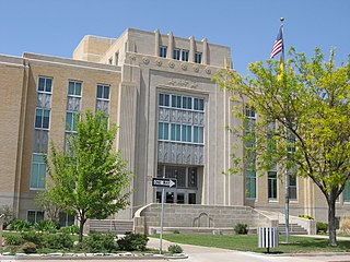
Roosevelt County is a county located in the U.S. state of New Mexico. As of the 2020 census, the population was 19,191. Its county seat is Portales. The county was created in 1903 from Chaves and Guadalupe counties and named for the then-current President of the United States, Theodore Roosevelt. The county's eastern border is the Texas state line.

<span class="mw-page-title-main">Quay County, New Mexico</span> County in New Mexico, United States

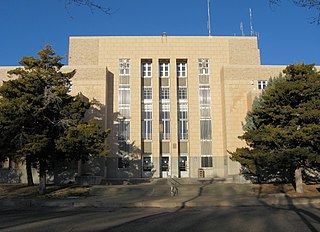
Quay County is a county in the state of New Mexico. As of the 2020 U.S. census, the population was 8,746. Its county seat is Tucumcari. The county was named for Pennsylvania senator Matthew Quay, who supported statehood for New Mexico. Its eastern border is the Texas state line, approximately 103.04 degrees west longitude.

<span class="mw-page-title-main">Prentiss County, Mississippi</span> County in Mississippi, United States

Prentiss County is a county located in the U.S. state of Mississippi. As of the 2020 census, the population was 25,008. Its county seat is Booneville. The county is named for Seargent Smith Prentiss, a noted speaker and US Congressman from Natchez.

<span class="mw-page-title-main">Lincoln County, Kentucky</span> County in Kentucky, United States

Lincoln County is a county located in south-central Kentucky. As of the 2020 census, the population was 24,275. Its county seat is Stanford. Lincoln County is part of the Danville, KY Micropolitan Statistical Area.

<span class="mw-page-title-main">Marion County, Iowa</span> County in Iowa, United States

Marion County is a county in the U.S. state of Iowa. As of the 2020 census, the population was 33,414. The county seat is Knoxville. It is named for Francis Marion, a brigadier general from South Carolina in the American Revolutionary War.

<span class="mw-page-title-main">Clay, West Virginia</span> Town in West Virginia, United States

Clay is a town in and the county seat of Clay County, West Virginia, United States. The population was 399 at the 2020 census. It is the only incorporated town in Clay County.

<span class="mw-page-title-main">Anawalt, West Virginia</span> Town in West Virginia, United States

Anawalt is a town in McDowell County, West Virginia, United States. At one time it was known as Jeanette. It is named in honor of James White Anawalt, who was then manager of Union Supply Company, a subsidiary of the United States Steel Company. The population was 186 at the 2020 census. Coal mining was the town's chief industry.

<span class="mw-page-title-main">Iaeger, West Virginia</span> Town in West Virginia, United States

Iaeger is a town in McDowell County, West Virginia, United States. The population was 257 at the 2020 census.

<span class="mw-page-title-main">Blacksville, West Virginia</span> Town in West Virginia

Blacksville is an Incorporated Town in Monongalia County, West Virginia, United States. The population was 118 at the 2020 census. It is included in the Morgantown, West Virginia Metropolitan Statistical Area.

References

  1. 1 2 "State & County QuickFacts". United States Census Bureau. Retrieved October 20, 2022.
  2. "Find a County". National Association of Counties. Archived from the original on May 31, 2011. Retrieved June 7, 2011.
  3. "Clay County history sources". Archived from the original on May 29, 2013. Retrieved January 29, 2013.
  4. "2010 Census Gazetteer Files". United States Census Bureau. August 22, 2012. Retrieved July 23, 2015.
  5. Otis K. Rice & Stephen W. Brown, West Virginia: A History, 2nd ed., University Press of Kentucky, Lexington (1993), p. 240.
  6. United States Census Bureau, U.S. Decennial Census, Tables of Minor Civil Divisions in West Virginia, 1870–2010.
  7. Whang, Oliver; McGarvey, Maddie (September 19, 2022). "A Rural Doctor Gave Her All. Then Her Heart Broke". The New York Times. ISSN   0362-4331 . Retrieved September 19, 2022.
  8. "Annual Estimates of the Resident Population for Counties: April 1, 2020 to July 1, 2021" . Retrieved October 20, 2022.
  9. "U.S. Decennial Census". United States Census Bureau. Retrieved January 9, 2014.
  10. "Historical Census Browser". University of Virginia Library. Archived from the original on August 11, 2012. Retrieved January 9, 2014.
  11. "Population of Counties by Decennial Census: 1900 to 1990". United States Census Bureau. Retrieved January 9, 2014.
  12. "Census 2000 PHC-T-4. Ranking Tables for Counties: 1990 and 2000" (PDF). United States Census Bureau. Retrieved January 9, 2014.
  13. 1 2 3 "DP-1 Profile of General Population and Housing Characteristics: 2010 Demographic Profile Data". United States Census Bureau. Archived from the original on February 13, 2020. Retrieved April 3, 2016.
  14. "Population, Housing Units, Area, and Density: 2010 - County". United States Census Bureau. Archived from the original on February 13, 2020. Retrieved April 3, 2016.
  15. "DP02 SELECTED SOCIAL CHARACTERISTICS IN THE UNITED STATES – 2006-2010 American Community Survey 5-Year Estimates". United States Census Bureau. Archived from the original on February 13, 2020. Retrieved April 3, 2016.
  16. "DP03 SELECTED ECONOMIC CHARACTERISTICS – 2006-2010 American Community Survey 5-Year Estimates". United States Census Bureau. Archived from the original on February 13, 2020. Retrieved April 3, 2016.
  17. Leip, David. "Dave Leip's Atlas of U.S. Presidential Elections". uselectionatlas.org. Retrieved March 27, 2018.

38°28′N81°04′W / 38.46°N 81.07°W / 38.46; -81.07