Taylor County, West Virginia

Last updated

Taylor County
Clelland House at maximum zoom.jpg
Clelland House, built in 1800.
Seal of Taylor County, West Virginia.png
Map of West Virginia highlighting Taylor County.svg
Location within the U.S. state of West Virginia
West Virginia in United States.svg
West Virginia's location within the U.S.
Coordinates: 39°20′N80°03′W / 39.34°N 80.05°W / 39.34; -80.05
CountryFlag of the United States.svg United States
StateFlag of West Virginia.svg  West Virginia
FoundedJanuary 19, 1844
Named for John Taylor of Caroline
Seat Grafton
Largest cityGrafton
Area
  Total176 sq mi (460 km2)
  Land173 sq mi (450 km2)
  Water2.9 sq mi (8 km2)  1.7%
Population
 (2020)
  Total16,705
  Estimate 
(2021)
16,492 Decrease2.svg
  Density95/sq mi (37/km2)
Time zone UTC−5 (Eastern)
  Summer (DST) UTC−4 (EDT)
Congressional district 1st
Website www.wvcountytaylor.com

Taylor County is a county in the U.S. state of West Virginia. As of the 2020 census, the population was 16,705. [1] Its county seat is Grafton. [2] The county was formed in 1844 [3] and named for Senator John Taylor of Caroline.

Contents

Taylor County is part of the Clarksburg, WV Micropolitan Statistical Area.

History

This area was populated by the Adena culture in the Pre-Columbian Woodland period of the Native Americans in the United States.

Some of the first Europeans to visit the area are thought to have been British Army deserters from Fort Pitt, who reportedly fled their post in 1761 during the French and Indian War and roamed northwestern Virginia for several years thereafter. A European trader with the Hudson's Bay Company reportedly set foot in these lands as early as 1764. [4]

Pruntytown is the oldest (ca. 1798) known white settlement in what is now Taylor County. Initially known as Cross Roads, on January 1, 1801, it was renamed Williamsport in honor of Abraham Williams, a longtime resident. The name was changed again on January 23, 1845, to honor pioneer settler John Prunty, Sr (1745-1823) and son David. This town served as the county seat of government from the county's founding in 1844 until a county election in 1878 moved that honor to Grafton, West Virginia. [4]

The county was established by the Virginia General Assembly on January 19, 1844. It was formed out of parts of Barbour, Harrison, and Marion counties in Virginia. Most historians think the county was named after John Taylor (1753-1824) of Caroline County, Virginia, while a minority believe it was named after Zachary Taylor. [4] Fifteen justices were appointed by Governor James McDowell to organize the newly formed county: John Asbury, Frederick Burdett, Dr. Joseph L. Carr, John Cather, John A. Guseman, Nathan Hall, Calder Haymond, Absalom Knotts, John Leeper, Charles W. Newlon, Jonathan Poe, Robert Reed, Joshua A. Robinson, William A. Rogers, and Benjamin Sinclair.

On June 20, 1863, at the height of the Civil War, Taylor was one of fifty Virginia counties that were admitted to the Union as the state of West Virginia. Later that year, the counties were divided into civil townships, with the intention of encouraging local government. This proved impractical in the heavily rural state, and in 1872 the townships were converted into magisterial districts. [5] Taylor County was initially divided into nine townships: Booths Creek, [lower-roman 1] Clay, Court House, Fetterman, Flemington, Grafton, Haymond, Union, and Webster. Grafton Township was co-extensive with the town of Grafton. [6]

In 1871, Union Township was annexed by Grafton Township; the following year, Clay and Webster Townships were annexed by Court House Township, Haymond was annexed by Fetterman, and the five remaining townships were converted to magisterial districts. In the 1880s, Knottsville District was created from the part of Grafton District that lay outside the town of Grafton. Except for minor adjustments, the six historic districts remained largely unchanged for the next ninety years, until in the 1970s they were consolidated into three new magisterial districts: Central, Eastern, and Western. In the 1990s, Central District was renamed, becoming Tygart. [6]

The West Virginia Equal Suffrage Association was founded in November 1895 at the Taylor County Courthouse [7] after a meeting called by leaders of the National American Woman Suffrage Association.

Anna Jarvis, the founder of the Mother's Day, was a native of Taylor County, which is now home to the International Mother's Day Shrine.

Geography

According to the United States Census Bureau, the county has a total area of 176 square miles (460 km2), of which 173 square miles (450 km2) is land and 2.9 square miles (7.5 km2) (1.7%) is water. [8] It is the fifth-smallest county in West Virginia by area.

Major highways

Adjacent counties

Demographics

Historical population
CensusPop.Note
1850 5,367
1860 7,46339.1%
1870 9,36725.5%
1880 11,45522.3%
1890 12,1476.0%
1900 14,97823.3%
1910 16,55410.5%
1920 18,74213.2%
1930 19,1142.0%
1940 19,9194.2%
1950 18,422−7.5%
1960 15,010−18.5%
1970 13,878−7.5%
1980 16,58419.5%
1990 15,144−8.7%
2000 16,0896.2%
2010 16,8955.0%
2020 16,705−1.1%
2021 (est.)16,492 [9] −1.3%
U.S. Decennial Census [10]
1790–1960 [11] 1900–1990 [12]
1990–2000 [13] 2010–2020 [1]

2020 census

As of the 2020 United States census, there were 16,705 people and 6,557 households residing in the county. There were 7,441 housing units in Taylor. The racial makeup of the county was 94% White, 0.7% African American, 0.2% Asian, 0.1% Native American, 0.2% from other races, and 4.7% from two or more races. Hispanics or Latinos of any race were 1.1% of the population.

Of the 6,557 households, 51.1% were married couples living together, 23.2% had a female householder with no spouse present, 18.1% had a male householder with no spouse present. The average household and family size was 3.08. The median age in the county was 44.1 years with 20.2% of the population under 18. The median income for a household was $52,823 and the poverty rate was 16.2%. [14]

2010 census

As of the 2010 United States census, there were 16,895 people, 6,778 households, and 4,703 families living in the county. [15] The population density was 97.8 inhabitants per square mile (37.8/km2). There were 7,541 housing units at an average density of 43.6 units per square mile (16.8 units/km2). [16] The racial makeup of the county was 97.5% white, 0.7% black or African American, 0.4% Asian, 0.2% American Indian, 0.1% from other races, and 1.0% from two or more races. Those of Hispanic or Latino origin made up 0.8% of the population. [15] In terms of ancestry, 26.1% were German, 22.9% were Irish, 11.3% were American, 10.3% were English, 7.2% were Italian, and 5.1% were Dutch. [17]

Of the 6,778 households, 29.3% had children under the age of 18 living with them, 53.6% were married couples living together, 10.6% had a female householder with no husband present, 30.6% were non-families, and 26.1% of all households were made up of individuals. The average household size was 2.42 and the average family size was 2.89. The median age was 42.3 years. [15]

The median income for a household in the county was $36,956 and the median income for a family was $45,620. Males had a median income of $38,085 versus $26,292 for females. The per capita income for the county was $18,562. About 11.3% of families and 15.8% of the population were below the poverty line, including 21.6% of those under age 18 and 16.0% of those age 65 or over. [18]

2000 census

As of the census of 2000, there were 16,089 people, 6,320 households, and 4,487 families living in the county. The population density was 93 people per square mile (36 people/km2). There were 7,125 housing units at an average density of 41 units per square mile (16 units/km2). The racial makeup of the county was 98.07% White, 0.83% Black or African American, 0.19% Native American, 0.17% Asian, 0.04% Pacific Islander, 0.06% from other races, and 0.63% from two or more races. 0.59% of the population were Hispanic or Latino of any race.

There were 6,320 households, out of which 30.90% had children under the age of 18 living with them, 56.40% were married couples living together, 10.90% had a female householder with no husband present, and 29.00% were non-families. 25.50% of all households were made up of individuals, and 12.60% had someone living alone who was 65 years of age or older. The average household size was 2.47 and the average family size was 2.95.

In the county, the population was spread out, with 22.90% under the age of 18, 7.90% from 18 to 24, 28.50% from 25 to 44, 24.90% from 45 to 64, and 15.80% who were 65 years of age or older. The median age was 39 years. For every 100 females, there were 95.70 males. For every 100 females age 18 and over, there were 92.90 males.

The median income for a household in the county was $27,124, and the median income for a family was $32,222. Males had a median income of $29,349 versus $20,116 for females. The per capita income for the county was $13,681. About 15.30% of families and 20.30% of the population were below the poverty line, including 27.00% of those under age 18 and 16.10% of those age 65 or over.

Politics

United States presidential election results for Taylor County, West Virginia [19] [20]
Year Republican Democratic Third party
No.%No.%No.%
2020 5,47774.18%1,79624.33%1101.49%
2016 4,73371.79%1,49122.61%3695.60%
2012 3,84064.85%1,94132.78%1402.36%
2008 3,60558.12%2,46239.69%1362.19%
2004 3,89359.43%2,61739.95%410.63%
2000 3,12454.69%2,47343.29%1152.01%
1996 1,97735.73%2,69248.65%86415.62%
1992 2,02233.07%2,84346.49%1,25020.44%
1988 2,81649.46%2,85250.09%260.46%
1984 4,00759.23%2,75440.71%40.06%
1980 3,01046.40%3,21649.58%2614.02%
1976 2,89142.54%3,90557.46%00.00%
1972 4,38567.77%2,08532.23%00.00%
1968 3,01246.84%2,95345.92%4667.25%
1964 2,29234.04%4,44265.96%00.00%
1960 3,99253.36%3,48946.64%00.00%
1956 4,74360.64%3,07939.36%00.00%
1952 4,71155.67%3,75244.33%00.00%
1948 3,94850.16%3,88849.40%350.44%
1944 3,89051.57%3,65348.43%00.00%
1940 4,84149.35%4,96850.65%00.00%
1936 4,06141.03%5,79558.55%420.42%
1932 3,85646.54%4,29351.82%1361.64%
1928 5,10166.20%2,54833.07%560.73%
1924 3,68353.45%2,49936.27%70810.28%
1920 3,64960.02%2,31138.01%1201.97%
1916 2,00253.23%1,67244.46%872.31%
1912 79121.22%1,44538.77%1,49140.01%

Communities

City

Town

Magisterial districts

Current

  • Eastern
  • Tygart
  • Western

Historic

  • Booths Creek
  • Court House
  • Fetterman
  • Flemington
  • Grafton
  • Knottsville

Unincorporated communities

See also

Footnotes

  1. Spelled "Booth's Creek" before 1890.

Related Research Articles

<span class="mw-page-title-main">Barbour County, West Virginia</span> County in West Virginia, United States

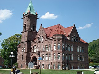
Barbour County is a county in north central West Virginia, United States. At the 2020 census, the population was 15,465. The county seat is Philippi, which was chartered in 1844. Both county and city were named for Philip P. Barbour (1783–1841), a U.S. Congressman from Virginia and Associate Justice of the U.S. Supreme Court. The county was formed in 1843 when the region was still part of the state of Virginia. In 1871, a small part of Barbour County was transferred to Tucker County, West Virginia.

<span class="mw-page-title-main">Braxton County, West Virginia</span> County in West Virginia, United States

Braxton County is a county in the central part of the U.S. state of West Virginia. As of the 2020 census, the population was 12,447. The county seat is Sutton. The county was formed in 1836 from parts of Lewis, Kanawha, and Nicholas counties and named for Carter Braxton, a Virginia statesman and signer of the Declaration of Independence.

<span class="mw-page-title-main">Wood County, West Virginia</span> County in West Virginia, United States

Wood County is a county in the U.S. state of West Virginia. As of the 2020 census, the population was 84,296, making it West Virginia's fifth-most populous county. Its county seat is Parkersburg. The county was formed in 1798 from the western part of Harrison County and named for James Wood, governor of Virginia from 1796 to 1799.

<span class="mw-page-title-main">Wirt County, West Virginia</span> County in West Virginia, United States

Wirt County is a county in the U.S. state of West Virginia. As of the 2020 census, the population was 5,194, making it the least populous county in West Virginia. Its county seat is Elizabeth. The county was created in 1848 by the Virginia General Assembly and named for U.S. Attorney General and presidential candidate William Wirt. The county is served by one high school, Wirt County High School.

<span class="mw-page-title-main">Webster County, West Virginia</span> County in West Virginia, United States

Webster County is a county in the U.S. state of West Virginia. As of the 2020 census, the population was 8,378. Its county seat is Webster Springs. The county was founded in 1860 and named for Daniel Webster.

<span class="mw-page-title-main">Randolph County, West Virginia</span> County in West Virginia, United States

Randolph County is a county located in the U.S. state of West Virginia. As of the 2020 census, the population was 27,932. Its county seat is Elkins. The county was founded in 1787 and is named for Edmund Jennings Randolph.

<span class="mw-page-title-main">Pleasants County, West Virginia</span> County in West Virginia, United States

Pleasants County is a county located in the U.S. state of West Virginia. At the 2020 census, the population was 7,653. Its county seat is St. Marys.

<span class="mw-page-title-main">Nicholas County, West Virginia</span> County in West Virginia, United States

Nicholas County is a county located in the central region of U.S. state of West Virginia. As of the 2020 census, the population was 24,604. Its county seat is Summersville. The county was created in 1818 by the Virginia General Assembly and named for Virginia Governor Wilson Cary Nicholas.

<span class="mw-page-title-main">Lincoln County, West Virginia</span> County in West Virginia, United States

Lincoln County is a county in the U.S. state of West Virginia. As of the 2020 census, the population was 20,463. Its county seat is Hamlin. The county was created in 1867 and named for Abraham Lincoln.

<span class="mw-page-title-main">Harrison County, West Virginia</span> County in West Virginia, United States

Harrison County is a county in the U.S. state of West Virginia. As of the 2020 census, the population was 65,921. Its county seat is Clarksburg.

<span class="mw-page-title-main">Grant County, West Virginia</span> County in West Virginia, United States

Grant County is a county in the U.S. state of West Virginia. As of the 2020 census, the population was 10,976. Its county seat is Petersburg. The county was created from Hardy County in 1866 and named for Civil War General and the 18th president of the United States Ulysses S. Grant.

<span class="mw-page-title-main">Calhoun County, West Virginia</span> County in West Virginia, United States

Calhoun County is a county in the U.S. state of West Virginia. As of the 2020 census, the population was 6,229, making it the third-least populous county in West Virginia. Its county seat is Grantsville. The county was founded in 1856 and named for South Carolina politician John C. Calhoun.

<span class="mw-page-title-main">East Taylor Township, Cambria County, Pennsylvania</span> Township in Pennsylvania, United States

East Taylor Township is a township in Cambria County, Pennsylvania, United States, The population was 2,726 at the 2010 census, unchanged since the 2000 census. It is part of the Johnstown, Pennsylvania Metropolitan Statistical Area.

<span class="mw-page-title-main">West Taylor Township, Pennsylvania</span> Township in Pennsylvania, United States

West Taylor Township is a township that is located in Cambria County, Pennsylvania, United States. The population was 795 at the time of the 2010 census.

<span class="mw-page-title-main">Junior, West Virginia</span> Town in West Virginia, United States

Junior is a town in Barbour County, West Virginia, United States, situated along the Tygart Valley River. The population was 384 at the 2020 census.

<span class="mw-page-title-main">Pleasant Valley, Marion County, West Virginia</span> City in West Virginia, United States

Pleasant Valley is a city in Marion County, West Virginia, United States. The population was 3,506 at the 2020 census.

<span class="mw-page-title-main">Beverly, West Virginia</span> Town in West Virginia, United States

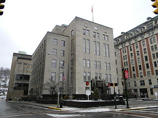
Beverly is a town in Randolph County, West Virginia, United States. Founded in 1787, it is the oldest settlement in the Tygart River Valley. It had a population of 628 at the 2020 census. Beverly was the county seat of Randolph County for over a century—from 1790 until 1899—after which the nearby settlement of Elkins assumed that role following an intense local political "war".

<span class="mw-page-title-main">Huttonsville, West Virginia</span> Town in West Virginia, United States

Huttonsville is a town in Randolph County, West Virginia, United States, along the Tygart Valley River. The population was 163 at the 2020 census.

<span class="mw-page-title-main">Mill Creek, West Virginia</span> Town in West Virginia, United States

Mill Creek is a town in Randolph County, West Virginia, United States, along the Tygart Valley River. The population was 563 at the 2020 census.

<span class="mw-page-title-main">Grafton, West Virginia</span> City in West Virginia, United States

Grafton is a city in and the county seat of Taylor County, West Virginia, United States, along the Tygart Valley River. The population was 4,729 at the 2020 census. It originally developed as a junction point for the Baltimore and Ohio Railroad, serving numerous branches of a network that was vital to the regional coal industry.

References

  1. 1 2 "State & County QuickFacts". United States Census Bureau. Retrieved August 14, 2022.
  2. "Find a County". National Association of Counties. Retrieved June 7, 2011.
  3. "Taylor County history sources". Archived from the original on November 23, 2007. Retrieved November 23, 2007.
  4. 1 2 3 ["Early History of Taylor County," West Virginia University "Early History of Taylor County". Archived from the original on August 5, 2012. Retrieved May 8, 2010.]
  5. Otis K. Rice & Stephen W. Brown, West Virginia: A History, 2nd ed., University Press of Kentucky, Lexington (1993), p. 240.
  6. 1 2 United States Census Bureau, U.S. Decennial Census, Tables of Minor Civil Divisions in West Virginia, 1870–2010.
  7. Anthony, Susan B.; Avery, Rachel Foster; Catt, Carrie Chapman (November 20, 1895). "Woman Suffrage, A State Convention Called for Grafton, on the 25th and 26th Inst". Wheeling [W.Va.] Register. Chronicling America: Historic American Newspapers, Lib. of Congress. Retrieved May 2, 2020.
  8. "2010 Census Gazetteer Files". United States Census Bureau. August 22, 2012. Retrieved July 31, 2015.
  9. "Annual Estimates of the Resident Population for Counties: April 1, 2020 to July 1, 2021" . Retrieved August 14, 2022.
  10. "U.S. Decennial Census". United States Census Bureau. Retrieved January 11, 2014.
  11. "Historical Census Browser". University of Virginia Library. Retrieved January 11, 2014.
  12. "Population of Counties by Decennial Census: 1900 to 1990". United States Census Bureau. Retrieved January 11, 2014.
  13. "Census 2000 PHC-T-4. Ranking Tables for Counties: 1990 and 2000" (PDF). United States Census Bureau. Archived (PDF) from the original on March 27, 2010. Retrieved January 11, 2014.
  14. "Explore Census Data". data.census.gov. Retrieved April 11, 2023.
  15. 1 2 3 "DP-1 Profile of General Population and Housing Characteristics: 2010 Demographic Profile Data". United States Census Bureau. Archived from the original on February 13, 2020. Retrieved April 3, 2016.
  16. "Population, Housing Units, Area, and Density: 2010 - County". United States Census Bureau. Archived from the original on February 13, 2020. Retrieved April 3, 2016.
  17. "DP02 SELECTED SOCIAL CHARACTERISTICS IN THE UNITED STATES – 2006-2010 American Community Survey 5-Year Estimates". United States Census Bureau. Archived from the original on February 13, 2020. Retrieved April 3, 2016.
  18. "DP03 SELECTED ECONOMIC CHARACTERISTICS – 2006-2010 American Community Survey 5-Year Estimates". United States Census Bureau. Archived from the original on February 13, 2020. Retrieved April 3, 2016.
  19. Leip, David. "Dave Leip's Atlas of U.S. Presidential Elections". uselectionatlas.org. Retrieved March 28, 2018.
  20. The leading "other" candidate, Progressive Theodore Roosevelt, received 1,316 votes, while Socialist candidate Eugene Debs received 175 votes.

Further reading

39°20′N80°03′W / 39.34°N 80.05°W / 39.34; -80.05