Grafton, West Virginia

Last updated

Grafton, West Virginia
Overlooking what what were once bustling rail lines of the Baltimore & Ohio Railroad in Grafton, West Virginia, which was an early B&O hub LCCN2015631657.tif
Grafton CSX yard, with the city's downtown in the background
Flag of Grafton, West Virginia.svg
Seal of Grafton, West Virginia.png
Logo of Grafton, West Virginia.png
Taylor County West Virginia Incorporated and Unincorporated areas Grafton Highlighted.svg
Location of Grafton in Taylor County, West Virginia.
Coordinates: 39°20′30″N80°1′11″W / 39.34167°N 80.01972°W / 39.34167; -80.01972
CountryUnited States
State West Virginia
County Taylor
Government
   City Manager Kevin Stead [1]
Area
[2]
  Total3.80 sq mi (9.85 km2)
  Land3.67 sq mi (9.51 km2)
  Water0.13 sq mi (0.34 km2)
Elevation
[3]
1,024 ft (312 m)
Population
 (2020) [4]
  Total4,729
  Estimate 
(2021) [4]
4,651
  Density1,356.75/sq mi (523.77/km2)
Time zone UTC-5 (Eastern (EST))
  Summer (DST) UTC-4 (EDT)
ZIP code
26354
Area code 304
FIPS code 54-32716 [5]
GNIS feature ID1554590 [3]
Website www.graftonwv.org

Grafton is a city in and the county seat of Taylor County, West Virginia, United States, along the Tygart Valley River. [6] The population was 4,729 at the 2020 census. [4] It originally developed as a junction point for the Baltimore and Ohio Railroad, serving numerous branches of a network that was vital to the regional coal industry.

Contents

Grafton is the home of both of West Virginia's national cemeteries, and was where the West Virginia Equal Suffrage Association formed in 1895. [7] Mother's Day was founded in Grafton on May 10, 1908, and the city is home to the International Mother's Day Shrine. [8] Grafton was also among the first cities in the United States to observe Memorial Day. [8]

History

Etymology

The origin of the name "Grafton" — originally Grafton Junction [9] — is disputed. The city may have been named for John Grafton, a civil engineer of the Baltimore and Ohio Railroad. [10] Alternatively, railroad crews may have referred to the town as "Graftin" because it was the point at which a number of branch railroad lines met (grafted to) the railroad's mainline. [11]

Earliest settlers

Grafton developed from early white settlements at the confluence of Three Fork Creek with the Tygart Valley River, part of the headwaters region of the Monongahela River watershed. In 1776, Virginia's remote District of West Augusta was divided into three counties, including Monongalia County, which included what are now Taylor County and Grafton.

Among the earliest settlers were James Current (ca. 1730–1822) and his family. He was a Scots-Irish immigrant who fought in the Revolutionary War in 1778, had landed in Maryland and moved into the interior. He was living in Monongalia County with his family by 1782 when he was recorded on a census there. [12] According to family tradition, Current traded a "gray horse" for 1,300 acres of land located where present-day Grafton developed. [13] James and his wife Margaret are buried in Bluemont Cemetery (part of his original property). Current's grave is the only one in Grafton known to belong to a veteran of the Revolutionary War. [10]

Turnpike and railroad

Grafton in 1859, from the Historic American Engineering Review - HAER Photocopied December 1972 from original in collection of Mr. Roy Boliger, Grafton, WV, 1857. VIEW OF GRAFTON, WV. - Northwestern Virginia (BandO) Railroad, Grafton Machine Shop HAER WVA,46-GRAFT,1-1.tif
Grafton in 1859, from the Historic American Engineering Review – HAER

John Wolverton Blue (1803–1889) was in charge of the construction of Virginia's Northwestern Turnpike from Aurora to the Tygart Valley. Visiting the future site of Grafton in 1833, he stayed overnight with the Currents. [14] According to a local historian, "Blue, upon awakening the next morning, heard the wife of Current sobbing bitterly" over the impending loss of her "cabin home...[and] vegetable and flower garden" because of the planned right-of-way for the road. "Mr. Blue, a Virginian of the old school, was greatly moved...and...an offer of $300 for 900 acres...and their ruined home...was quickly accepted." [15]

This neighborhood (now a suburb of Grafton) became known as Blueville and it — along with the nearby area called "Valley Bridge" (present day Fetterman, or Ward 1) — began to grow after the Turnpike was completed in 1834. [16] Blue also supervised the construction of a (now long gone) covered bridge over the Tygart here at this time.

In 1847, the Virginia General Assembly passed an act authorizing the Baltimore and Ohio Railroad Company to extend its line to the Ohio River at Wheeling. The city of Grafton owes its existence to the interventions of Thomas S. Haymond (1794–1869), a lawyer and U.S. Congressman (and future Confederate colonel) from nearby Marion County. According to another local historian, "Haymond never mentioned his county as desiring the [rail]road; but being well acquainted with the geography of north-western Virginia, he quietly got the following clause attached to the bill: 'That the said railroad to be constructed through the territory of Virginia, shall reach or cross the Tygart's Valley River at or within three miles of the mouth of Three Fork Creek in the county of Taylor'". [17] This clause effectively re-routed the line away from Morgantown and forced it to pass through Haymond's hometown of Fairmont. Grafton, which is perched in unlikely fashion on a very steep hillside at the mentioned confluence, was the accidental beneficiary, also becoming the branch point for the side line north to Morgantown.

The Grafton B&O Depot The old Baltimore & Ohio Railroad Station in Grafton, West Virginia, built in 1911, a year before 30 passenger trains a day passed through this B&O junction town LCCN2015631675.tif
The Grafton B&O Depot

The B&O work crews completed the line on January 11, 1852, and the first "iron horse" arrived two days later. This was the first trans-Appalachian railroad. Within a year Grafton had emerged as a booming railroad town with several residences and stores. As the railroad facilities were developed, local land was surveyed for the new town, which was chartered on March 15, 1856, in the Virginia General Assembly. [18]

Civil War

Due to the importance of the B&O and Northwestern Virginia Railroads for the movement of troops and supplies, Grafton became an early strategic target during the Civil War; both sides tried to control it. CSA General Robert E. Lee initially vowed to protect the railroad, and sent first CSA Major Francis M. Boykin Jr., then CSA Col. George A. Porterfield (a Virginia Military Institute graduate from Charles Town across from Harpers Ferry) to recruit at Grafton, but neither had much success. [19] Most Grafton residents, immigrants brought in to work for the railroad, sided with the Union. [20] The Grafton Guards led by Col. George R. Latham became Company B of the 2nd West Virginia Infantry Regiment days after Virginians (over the objection of most of western Virginia) voted for secession on May 23. [21]

The previous evening (May 22, 1861), opposing factions skirmished in the Town of Fetterman (now a part of Grafton), resulting in the death of Thornsbury Bailey Brown, the first soldier killed in the Civil War. Southern supporters joined the Confederate Letcher's Guard.

With the Grafton Guards in Wheeling, Porterfield occupied Grafton on May 25, but left three days later for Philippi, when he realized his vastly outnumbered forces were facing a pincer movement from troops under the Wheeling militia's Col. Benjamin Franklin Kelley (soon to become a Brigadier General and who would station his Railroad Division at Grafton) as well as various Ohio and Indiana units sent by Union General George McClellan, a U.S. Army officer turned railroad man whom President Lincoln had placed in charge of the Department of the Ohio. Kelley planned to attack the Confederates and drive them away from the vital railroads. Although reinforced by about 400 men at Philippi, the Confederates, realizing themselves vastly outnumbered in the June 3 attack, fled, leaving more than 750 muskets, ammunition, wagons, horses, medical supplies and tents behind, so the Battle of Philippi (West Virginia) would sometimes be called the "Philippi Races." Gen. Lee soon replaced Porterfield with CSA Gen. Robert S. Garnett. [22]

Although the Union controlled Grafton, Confederates often raided and vandalized to disrupt railroad operations. The Northwestern Virginia Railroad and its rail yard and machine shops at Grafton were also a probable objective of the Jones-Imboden Raid in April 1863. Raiders did destroy the 3-span bridge across the Monongahela River at Fairmont due north of Grafton (the largest on the line) as well as several smaller bridges, but Grafton's rail yards, which were protected by Mulligan's Brigade, the First and Eighth Maryland, and Miner's Indiana battery, were not attacked. [23]

Post-war growth

Photocopied December 1972 from original in collection of Mr. Roy Boliger, Grafton, WV, 1876. VIEW OF GRAFTON, WV. - Northwestern Virginia (BandO) Railroad, Grafton Machine Shop HAER WVA,46-GRAFT,1-4.tif
1876
Photocopy of photograph, 1972. GRAFTON BRIDGE, 1890. (From the original collection of Mr. Ray Boliger, Grafton, WV) - Northwestern Virginia Railroad, Grafton Bridge, Spanning HAER WVA,46-GRAFT,2-5.tif
1890

Following the Civil War, Grafton continued to grow and prosper, developing into a major retail and industrial center for North Central West Virginia. Grafton was visited by President U.S. Grant on September 23, 1872, as part of his reelection campaign. Grant's speech was interrupted several times by noisy southern sympathizers. [24]

In 1878, Grafton was designated as the county seat, replacing Pruntytown in this role. A massive flood which swept through town in 1888 wrought many changes, including destruction of the historic (1834) covered bridge at Fetterman. Most of present-day Grafton was built during the period from 1890 to 1930. John T. McGraw, a financier and major contributor to most of Grafton's buildings, was the principal town builder. Besides his bank, McGraw built a number of buildings along Main Street, and also the streetcar system that was used for many years.

20th century

Tygart Dam was constructed about 2 miles south of Grafton between 1934 and 1938, by the Works Progress Administration of the Franklin D. Roosevelt administration. President Roosevelt visited the city on a stump tour, and remarked on such projects on October 1, 1936; he gained a landslide re-election the following month. Upstream of the dam, Tygart Lake State Park was designated to preserve recreation areas around the man-made lake. The Tygart Valley River flows through Grafton.

Grafton continued to prosper throughout much of the early 20th century, based on the railroad's importance in both the area and the national economy. But in the early 1950s, the Carr China Plant closed and left hundreds of residents unemployed. In the late 1950s, Hazel Atlas Glass Plant closed and also left hundreds of residents without jobs. In 1958, the women of Grafton organized a parade on Main Street to attract jobs for residents of the community. This parade received national attention. Grafton was the chosen site of a plastic baby toys manufacturer. Because of the residents' efforts, Grafton was given an All-America City Award by the National Civic League in 1962, the smallest city that year to receive the award.

Although instrumental to the city's early growth and economy, the railroad inhibited its expansion. In the 1920s smoke abatement experts reported that the combination of high hills, low wind velocity, and frequent railroad traffic, created air quality problems for the city and its business district, which was adjacent to the area of intense railroad activity. The resulting smoke from the railroad industry was a chief factor in hindering the growth of the city. Restructuring of the railroads and heavy industry through the late 20th century resulted in the loss of more jobs and, ultimately, population. People moved elsewhere for work. [25]

The Metropolitan Special at Grafton Station in July 1970 B&O Metropolitan at Grafton, July 1970 (27673473985).jpg
The Metropolitan Special at Grafton Station in July 1970

In the early 1980s, the railroad relocated hundreds of jobs to Jacksonville, Florida, as the Chessie System aimed to form CSX. Grafton suffered a severe economic and emotional loss from these changes.

The 1985 Election day floods were notable in Grafton. Most of the 47 people killed in this incident were in Pendleton and Grant counties, according to the National Weather Service. [26] Flooding in the Tygart Valley River basin (a tributary to the Monongahela River) set new records for peak discharge at all five of the long-term unregulated gauging stations in the basin. However, the peaks were not as extreme, relative to the previous peaks of record, as those in the Cheat River and South Branch Potomac River basins. Recurrence intervals for the peaks equaled or exceeded 50 years at all five of the aforementioned sites in the Tygart basin, and four were in excess of 100 years. Also, at one newly established gauging station, Three Forks Creek near Grafton, the peak discharge, 12,000 cubic feet per second (340 m3/s), was estimated to exceed the 100-year recurrence interval. [27]

Historic places

The Grafton Downtown Commercial Historic District was listed on the National Register of Historic Places in 1984 and the Grafton National Cemetery was listed in 1982. [28]

Geography

Grafton is located at 39°20′30″N80°1′11″W / 39.34167°N 80.01972°W / 39.34167; -80.01972 (39.341757, −80.019817), [29] along the Tygart Valley River. Tygart Lake State Park is a major nearby tourist attraction.

According to the United States Census Bureau, the city has a total area of 3.80 square miles (9.84 km2), of which 3.67 square miles (9.51 km2) is land and 0.13 square miles (0.34 km2) is water. [30]

Demographics

Historical population
CensusPop.Note
1860 891
1870 1,987123.0%
1880 3,03052.5%
1890 3,1594.3%
1900 5,65078.9%
1910 7,56333.9%
1920 8,51712.6%
1930 7,737−9.2%
1940 7,431−4.0%
1950 7,365−0.9%
1960 5,791−21.4%
1970 6,43311.1%
1980 6,8456.4%
1990 5,524−19.3%
2000 5,489−0.6%
2010 5,164−5.9%
2020 4,729−8.4%
2021 (est.)4,651 [4] −1.6%
U.S. Decennial Census [31]

2010 census

As of the census [32] of 2010, there were 5,164 people, 2,192 households, and 1,357 families residing in the city. The population density was 1,407.1 inhabitants per square mile (543.3/km2). There were 2,512 housing units at an average density of 684.5 per square mile (264.3/km2). The racial makeup of the city was 97.1% White, 0.7% African American, 0.3% Native American, 0.2% Asian, 0.1% from other races, and 1.5% from two or more races. Hispanic or Latino of any race were 0.9% of the population.

There were 2,192 households, of which 29.0% had children under the age of 18 living with them, 41.3% were married couples living together, 15.0% had a female householder with no husband present, 5.6% had a male householder with no wife present, and 38.1% were non-families. 33.8% of all households were made up of individuals, and 15.3% had someone living alone who was 65 years of age or older. The average household size was 2.29 and the average family size was 2.92.

The median age in the city was 41.7 years. 21.9% of residents were under the age of 18; 8.4% were between the ages of 18 and 24; 23.9% were from 25 to 44; 26.9% were from 45 to 64; and 19% were 65 years of age or older. The gender makeup of the city was 47.6% male and 52.4% female.

2000 census

As of the census [5] of 2000, there were 5,489 people, 2,277 households, and 1,448 families residing in the city. The population density was 1,491.1 inhabitants per square mile (575.7/km2). There were 2,575 housing units at an average density of 699.5 per square mile (270.1/km2). The racial makeup of the city was 98.07% White, 0.84% African American, 0.27% Native American, 0.16% Asian, 0.05% from other races, and 0.60% from two or more races. Hispanic or Latino people of any race comprised 0.67% of the population.

There were 2,277 households, out of which 29.4% had children under the age of 18 living with them, 45.4% were married couples living together, 14.2% had a female householder with no husband present, and 36.4% were non-families. 33.2% of all households were made up of individuals, and 17.9% had someone living alone who was 65 years of age or older. The average household size was 2.33 and the average family size was 2.95.

In the city the population was spread out, with 23.6% under the age of 18, 7.7% from 18 to 24, 25.4% from 25 to 44, 22.0% from 45 to 64, and 21.3% who were 65 years of age or older. The median age was 40 years. For every 100 females, there were 87.1 males. For every 100 females age 18 and over, there were 82.2 males.

The median income for a household in the city was $18,981, and the median income for a family was $25,161. Males had a median income of $22,765 versus $16,629 for females. The per capita income for the city was $9,616. About 26.6% of families and 35.1% of the population were below the poverty line, including 51.2% of those under age 18 and 15.7% of those age 65 or over.

National Cemeteries

Grafton National Cemetery Grafton National Cemetery.jpg
Grafton National Cemetery

Thornsbury Bailey Brown was the first soldier killed in the Civil War, at Fetterman, now part of Grafton. [10] He is interred at the Grafton National Cemetery. This was opened in 1868 to provide a burial ground for Union soldiers who died in West Virginia's military hospitals and battlefields. The Federal Government selected Grafton as the site of the national cemetery for its proximity to the Maple Avenue Cemetery, which already contained the remains of many US Civil War veterans.

On June 14, the first governor of West Virginia, Arthur Boreman, officially dedicated the cemetery. The cemetery contains more than 2,100 interments, including 1,252 Union soldiers. 613 Civil War soldiers are buried as unknowns and their graves are identified with six-inch square marble markers. In 1875, an Act of Congress was passed authorizing "preservation and maintenance" of the cemetery. Two plaques on the lowest terrace contain stanzas from Theodore O'Hara's poem "Bivouac of the Dead."

Memorial Day services at Grafton National Cemetery include a special tradition known locally as "Flower Strewing Day". Historically, each year a parade begins in downtown Grafton and winds to the cemetery, where town children place flowers at each grave marker. The day concludes with a memorial service officiated by a prominent West Virginian. Every governor, except one who served a term of only six days, has spoken at the Grafton National Cemetery at least once during their term in office. [33]

Notable people

International Mother's Day Shrine International Mothers Day Shrine.jpg
International Mother's Day Shrine

Related Research Articles

<span class="mw-page-title-main">Barbour County, West Virginia</span> County in West Virginia, United States

Barbour County is a county in north central West Virginia, United States. At the 2020 census, the population was 15,465. The county seat is Philippi, which was chartered in 1844. Both county and city were named for Philip P. Barbour (1783–1841), a U.S. Congressman from Virginia and Associate Justice of the U.S. Supreme Court. The county was formed in 1843 when the region was still part of the state of Virginia. In 1871, a small part of Barbour County was transferred to Tucker County, West Virginia.

<span class="mw-page-title-main">Wood County, West Virginia</span> County in West Virginia, United States

Wood County is a county in the U.S. state of West Virginia. As of the 2020 census, the population was 84,296, making it West Virginia's fifth-most populous county. Its county seat is Parkersburg. The county was formed in 1798 from the western part of Harrison County and named for James Wood, governor of Virginia from 1796 to 1799.

<span class="mw-page-title-main">Taylor County, West Virginia</span> County in West Virginia, United States

Taylor County is a county in the U.S. state of West Virginia. As of the 2020 census, the population was 16,705. Its county seat is Grafton. The county was formed in 1844 and named for Senator John Taylor of Caroline.

<span class="mw-page-title-main">Randolph County, West Virginia</span> County in West Virginia, United States

Randolph County is a county located in the U.S. state of West Virginia. As of the 2020 census, the population was 27,932. Its county seat is Elkins. The county was founded in 1787 and is named for Edmund Jennings Randolph.

<span class="mw-page-title-main">Pocahontas County, West Virginia</span> County in West Virginia, United States

Pocahontas County is a county located in the eastern part of the U.S. state of West Virginia. As of the 2020 census, the population was 7,869. Its county seat is Marlinton. The county was established in 1821. It is named after the daughter of the Powhatan chief of the Native Americans in the United States who came from Jamestown, Virginia. She married an English settler, and their children became ancestors of many of the First Families of Virginia.

<span class="mw-page-title-main">Olive Hill, Kentucky</span> City in Kentucky, United States

Olive Hill is a home rule-class city along Tygarts Creek in Carter County, Kentucky, in the United States. The population was 1,599 during the year 2010 U.S. Census.

<span class="mw-page-title-main">Belington, West Virginia</span> City in West Virginia

Belington is a town in Barbour County, West Virginia, United States, situated along the Tygart Valley River. The population was 1,804 as of the 2020 census.

<span class="mw-page-title-main">Philippi, West Virginia</span> City in West Virginia

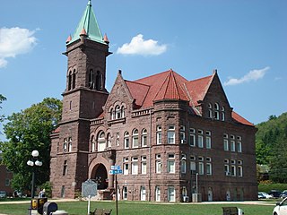
Philippi ('FILL-uh-pea') is a city in and the county seat of Barbour County, West Virginia, United States, along the Tygart Valley River. The population was 2,929 at the 2020 census. In 1861, the city was the site of the Battle of Philippi, known as the "Philippi Races". Although a minor skirmish, this is considered the earliest notable land action of the American Civil War. The city has a weekly newspaper, The Barbour Democrat.

<span class="mw-page-title-main">Clarksburg, West Virginia</span> City in West Virginia, United States

Clarksburg is a city in and the county seat of Harrison County, West Virginia, United States, in the north-central region of the state. The population of the city was 16,039 at the 2020 census, making it the tenth-most populous city in West Virginia. It is the principal city of the Clarksburg micropolitan area, which had a population of 90,434 in 2020. Clarksburg was named National Small City of the Year in 2011 by the National League of Cities.

<span class="mw-page-title-main">Fairmont, West Virginia</span> City in West Virginia, United States

Fairmont is a city in and county seat of Marion County, West Virginia, United States. The population was 18,313 at the 2020 census, making it the eighth-most populous city in the state. It is the principal city of the Fairmont micropolitan area, which includes all of Marion County in North Central West Virginia and had a population of 56,205 in 2020. Fairmont is also a principal city of the larger Morgantown–Fairmont combined statistical area.

<span class="mw-page-title-main">Moundsville, West Virginia</span> City in West Virginia, United States

Moundsville is a city in and the county seat of Marshall County, West Virginia, United States, along the Ohio River. The population was 8,122 at the 2020 census. It is part of the Wheeling metropolitan area. The city was named for the nearby ancient Grave Creek Mound, constructed 250 to 100 BC by indigenous people of the Adena culture.

<span class="mw-page-title-main">Elkins, West Virginia</span> City in West Virginia, United States

Elkins is a city in and the county seat of Randolph County, West Virginia, United States, along the Tygart Valley River. The community was incorporated in 1890 and named in honor of Stephen Benton Elkins, a U.S. Senator from West Virginia. The population was 6,950 at the 2020 census and estimated at 6,895 in 2021. Elkins is home to Davis and Elkins College and the Mountain State Forest Festival, held in early October every year.

<span class="mw-page-title-main">Mill Creek, West Virginia</span> Town in West Virginia, United States

Mill Creek is a town in Randolph County, West Virginia, United States, along the Tygart Valley River. The population was 563 at the 2020 census.

<span class="mw-page-title-main">Parkersburg, West Virginia</span> City in West Virginia, United States

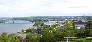
Parkersburg is a city in and the county seat of Wood County, West Virginia, United States. Located at the confluence of the Ohio and Little Kanawha rivers, it is the state's fourth-most populous city and the center of the Parkersburg–Vienna metropolitan area. The city's population was 29,749 at the 2020 census, and its metro population was 89,490. The city is about 14 miles (23 km) south of Marietta, Ohio.

<span class="mw-page-title-main">Battle of Philippi (1861)</span> Early battle of the American Civil War

The Battle of Philippi formed part of the Western Virginia Campaign of the American Civil War and was fought in and around Philippi, Virginia, on June 3, 1861. A Union Army victory, it was the first organized land action of the war, though generally viewed as a skirmish rather than a battle.

<span class="mw-page-title-main">Tygart Valley River</span> River in West Virginia, United States

The Tygart Valley River — also known as the Tygart River — is a principal tributary of the Monongahela River, approximately 135 miles (217 km) long, in east-central West Virginia in the United States. Via the Monongahela and Ohio rivers, it is part of the watershed of the Mississippi River, draining an area of 1,329 square miles (3,440 km2) in the Allegheny Mountains and the unglaciated portion of the Allegheny Plateau.

<span class="mw-page-title-main">U.S. Route 50 in West Virginia</span> Segment of American highway

U.S. Route 50 in West Virginia runs from the border with Ohio to Virginia, passing briefly through Garrett County, Maryland, and following the Northwestern Turnpike. Prior to the U.S. Highway System it was West Virginia Route 1 and in the 1930s, the road was not finished in Maryland. Today the section of US 50 from Clarksburg to Parkersburg on the Ohio River is part of Corridor D of the Appalachian Development Highway System.

Fetterman is an unincorporated community or populated place located in Taylor County, West Virginia, United States. It is coterminous with Ward 1 of the city of Grafton.

The North Western Virginia Railroad was chartered by the Virginia General Assembly as the Northwestern Virginia Railroad on February 14, 1851, in order to build track from Grafton, West Virginia to Parkersburg, West Virginia. Future statehood advocate and U.S. Senator Peter G. Van Winkle of Parkersburg began as the Northwestern Railroad's secretary in 1852 and served as its president through the American Civil War.

References

Citations

  1. "City Manager - City of Grafton, WV". graftonwv.org. Retrieved December 30, 2019.
  2. "2019 U.S. Gazetteer Files". United States Census Bureau. Retrieved August 7, 2020.
  3. 1 2 U.S. Geological Survey Geographic Names Information System: Grafton, West Virginia
  4. 1 2 3 4 "City and Town Population Totals: 2020-2021". Census.gov. US Census Bureau. Retrieved July 2, 2022.
  5. 1 2 "U.S. Census website". United States Census Bureau . Retrieved January 31, 2008.
  6. "Find a County". National Association of Counties. Archived from the original on May 31, 2011. Retrieved June 7, 2011.
  7. Anthony, Susan B.; Avery, Rachel Foster; Catt, Carrie Chapman (November 20, 1895). "Woman Suffrage, A State Convention Called for Grafton, on the 25th and 26th Inst". Wheeling [W.Va.] Register. Chronicling America: Historic American Newspapers, Lib. of Congress. Retrieved May 2, 2020.
  8. 1 2 nps.gov: "National Register of Historic Places – Andrews Methodist Episcopal Church" Archived March 14, 2007, at the Wayback Machine
  9. Brinkman (1939–42), Op. cit., Vol. 1, pg 208.
  10. 1 2 3 graftonwv.com: "ABOUT GRAFTON" Archived October 28, 2010, at the Wayback Machine
  11. Gannett, Henry (1905). The Origin of Certain Place Names in the United States. Govt. Print. Off. pp.  140.
  12. Heads of families at the first census of the United States taken in the year 1790: records of the state enumerations, 1782 to 1785; Washington: G.P.O., 1908, pg 35.
  13. Current, Anne E. (1906), Genealogy of the Current and Hobson Families; New Castle, Indiana: Mark O. Waters, pp 2–4.
  14. Core, Earl L. (1974–84), The Monongalia Story: A Bicentennial History, Parsons, W. Va.: McClain Printing Co., 5 volumes; Vol. III: Discord (1979), pg 117.
  15. Brinkman, Charles (1939–42), The History of Taylor County, Chapt. 13; published in installments in the Grafton Sentinel; 2 May issue. (These newspaper columns, published from April 18, 1939, to June 29, 1942, by the Grafton Sentinel, are compiled by the Taylor County Historical and Genealogical Society in three volumes [Vol. 1, 1989; Vol. 2, 1992; Vol. 3, 1992]. The columns are produced as 890 "chapters" in the reprinted work.) James Current and his wife Margaret (Richardson) (1737–1830) had both died, so the "wife of Current" referred to may have been one of their daughters-in-law.
  16. Snider, Joseph Franklin (1945), "The Early History of Grafton", Graduate Theses, Dissertations, and Problem Reports. 7362. (Master's thesis for West Virginia University), pp 2-3.
  17. Core, Op. cit. , pg 292.
  18. "About Grafton". Archived from the original on October 28, 2010. Retrieved October 13, 2010.
  19. Daniel Carroll Toomey, The War Came by Train: the Baltimore & Ohio Railroad during the Civil War (Baltimore and Ohio Railroad Museum 2013) pp. 47–48 ISBN   978-1-886248-01-4
  20. Newell, Clayton R., Lee vs. McClellan, The first Campaign, Regnery Publishing Inc., 1996, pg. 71 ISBN   0-89526-452-8
  21. Toomey pp. 48–50, 78–79
  22. Toomey pp. 50–55
  23. Toomey pp. 151–152
  24. Brinkman (1939–42), Op. cit. , Vol. 1, pp 162–163.
  25. "History of Grafton, West Virginia", Rootsweb
  26. West Virginia Gazette: "Remembering the '85 floods" (D. White) November 4, 2010
  27. "FLOODS IN WEST VIRGINIA, VIRGINIA, PENNSYLVANIA, AND MARYLAND, NOVEMBER 1985" (DH Carpenter) USGS WRI report 88-4213 Towson, MD, 1990
  28. "National Register Information System". National Register of Historic Places . National Park Service. March 13, 2009.
  29. "US Gazetteer files: 2010, 2000, and 1990". United States Census Bureau. February 12, 2011. Retrieved April 23, 2011.
  30. "US Gazetteer files 2010". United States Census Bureau. Archived from the original on January 25, 2012. Retrieved January 24, 2013.
  31. "Census of Population and Housing". Census.gov. Retrieved June 4, 2015.
  32. "U.S. Census website". United States Census Bureau . Retrieved January 24, 2013.
  33. nps.gov: "Civil War Era National Cemeteries: Honoring Those Who Served – Grafton National Cemetery", National Park Service
  34. "Martin McNulty Crane". Texas Legislators: Past & Present. Texas Legislative Reference Library.
  35. Higgins, Cara, "WVPA Inducts Nuzum into Hall of Fame", The Inter-Mountain, August 6, 2009.

Other sources