Davis, West Virginia | |
---|---|
Coordinates: 39°7′52″N79°27′59″W / 39.13111°N 79.46639°W | |
Country | United States |
State | West Virginia |
County | Tucker |
Area | |
• Total | 1.83 sq mi (4.74 km2) |
• Land | 1.83 sq mi (4.74 km2) |
• Water | 0.00 sq mi (0.00 km2) |
Elevation | 3,100 ft (945 m) |
Population | |
• Total | 595 |
• Estimate (2021) [2] | 588 |
• Density | 344.62/sq mi (133.06/km2) |
Time zone | UTC-5 (Eastern (EST)) |
• Summer (DST) | UTC-4 (EDT) |
ZIP code | 26260 |
Area code | 304 |
FIPS code | 54-20428 [3] |
GNIS feature ID | 1550876 [4] |
Website | https://daviswv.us/ |
Davis is a town in Tucker County, West Virginia, United States, situated along the Blackwater River. [5] The population was 595 at the 2020 census. [2]
Davis was named either for Senator Henry Gassaway Davis, [6] or for his family generally. [7]
The Herman August Meyer House was listed on the National Register of Historic Places in 2010. [8]
Davis is located at 39°07′52″N79°27′59″W / 39.131110°N 79.466318°W (39.131110, -79.466318). [9] It is located in the northern portion of Canaan Valley, West Virginia near the Canaan Valley State Resort Park, and is partially surrounded by the Monongahela National Forest, including scenic Blackwater Falls.
At an elevation of 3,520 feet, Davis has the highest elevation of any West Virginia town.
According to the United States Census Bureau, the town has a total area of 1.83 square miles (4.74 km2), all land. [10]
The area surrounding Davis is renowned for its mountain biking trails and bike culture. The most notable trails include the Plantation Trail, Hoo Doo Hustle and Moon Rocks. Many more miles of trails are also easily accessible at nearby Blackwater Falls State Park. The area also hosts several mountain bike races each year. One of these races, the Revenge of the Rattlesnake, is considered one of the toughest bike races in the country.
Census | Pop. | Note | %± |
---|---|---|---|
1890 | 918 | — | |
1900 | 2,391 | 160.5% | |
1910 | 2,615 | 9.4% | |
1920 | 2,491 | −4.7% | |
1930 | 1,656 | −33.5% | |
1940 | 1,454 | −12.2% | |
1950 | 1,271 | −12.6% | |
1960 | 898 | −29.3% | |
1970 | 868 | −3.3% | |
1980 | 979 | 12.8% | |
1990 | 799 | −18.4% | |
2000 | 624 | −21.9% | |
2010 | 660 | 5.8% | |
2020 | 595 | −9.8% | |
2021 (est.) | 588 | [2] | −1.2% |
U.S. Decennial Census [11] |
At the 2010 census there were 660 people, 305 households, and 173 families living in the town. The population density was 360.7 inhabitants per square mile (139.3/km2). There were 425 housing units at an average density of 232.2 per square mile (89.7/km2). The racial makeup of the town was 98.0% White, 0.5% Native American, 0.5% from other races, and 1.1% from two or more races. Hispanic or Latino people of any race were 0.9%. [12]
Of the 305 households 20.0% had children under the age of 18 living with them, 43.6% were married couples living together, 9.2% had a female householder with no husband present, 3.9% had a male householder with no wife present, and 43.3% were non-families. 37.4% of households were one person and 15.4% were one person aged 65 or older. The average household size was 2.16 and the average family size was 2.82.
The median age in the town was 46.1 years. 17.7% of residents were under the age of 18; 6.8% were between the ages of 18 and 24; 24.1% were from 25 to 44; 34.9% were from 45 to 64; and 16.5% were 65 or older. The gender makeup of the town was 47.0% male and 53.0% female.
At the 2000 census there were 624 people, 290 households, and 176 families living in the town. The population density was 546.0 inhabitants per square mile (211.3/km2). There were 380 housing units at an average density of 332.5 per square mile (128.7/km2). The racial makeup of the town was 97.92% White, 0.16% Native American, and 1.92% from two or more races. Hispanic or Latino people of any race were 0.32%. [3]
Of the 290 households 26.2% had children under the age of 18 living with them, 44.5% were married couples living together, 11.7% had a female householder with no husband present, and 39.3% were non-families. 36.9% of households were one person and 20.0% were one person aged 65 or older. The average household size was 2.15 and the average family size was 2.76.
The age distribution was 22.0% under the age of 18, 6.1% from 18 to 24, 26.6% from 25 to 44, 23.4% from 45 to 64, and 22.0% 65 or older. The median age was 42 years. For every 100 females, there were 84.6 males. For every 100 females age 18 and over, there were 88.0 males.
The median household income was $25,221 and the median family income was $31,333. Males had a median income of $21,607 versus $17,250 for females. The per capita income for the town was $22,399. About 14.6% of families and 14.6% of the population were below the poverty line, including 19.4% of those under age 18 and 10.9% of those age 65 or over.
According to the Köppen Climate Classification system, Davis has a warm-summer humid continental climate, abbreviated "Dfb" on climate maps.
Climate data for Davis, West Virginia, 1991–2020 normals, extremes 2002–present | |||||||||||||
---|---|---|---|---|---|---|---|---|---|---|---|---|---|
Month | Jan | Feb | Mar | Apr | May | Jun | Jul | Aug | Sep | Oct | Nov | Dec | Year |
Record high °F (°C) | 62 (17) | 71 (22) | 74 (23) | 84 (29) | 83 (28) | 89 (32) | 89 (32) | 84 (29) | 84 (29) | 80 (27) | 72 (22) | 64 (18) | 89 (32) |
Mean maximum °F (°C) | 55.5 (13.1) | 56.1 (13.4) | 66.4 (19.1) | 76.7 (24.8) | 79.9 (26.6) | 81.9 (27.7) | 83.3 (28.5) | 81.1 (27.3) | 80.5 (26.9) | 74.7 (23.7) | 67.3 (19.6) | 58.1 (14.5) | 84.3 (29.1) |
Mean daily maximum °F (°C) | 31.9 (−0.1) | 34.9 (1.6) | 42.9 (6.1) | 55.8 (13.2) | 64.4 (18.0) | 71.5 (21.9) | 75.3 (24.1) | 73.6 (23.1) | 68.1 (20.1) | 57.3 (14.1) | 45.7 (7.6) | 36.4 (2.4) | 54.8 (12.7) |
Daily mean °F (°C) | 23.9 (−4.5) | 26.2 (−3.2) | 33.5 (0.8) | 45.0 (7.2) | 54.6 (12.6) | 62.2 (16.8) | 66.0 (18.9) | 64.4 (18.0) | 58.8 (14.9) | 47.8 (8.8) | 37.2 (2.9) | 28.8 (−1.8) | 45.7 (7.6) |
Mean daily minimum °F (°C) | 15.9 (−8.9) | 17.5 (−8.1) | 24.0 (−4.4) | 34.3 (1.3) | 44.9 (7.2) | 52.8 (11.6) | 56.6 (13.7) | 55.2 (12.9) | 49.5 (9.7) | 38.4 (3.6) | 28.7 (−1.8) | 21.2 (−6.0) | 36.6 (2.6) |
Mean minimum °F (°C) | −5.6 (−20.9) | −4.8 (−20.4) | 4.4 (−15.3) | 18.3 (−7.6) | 28.9 (−1.7) | 39.8 (4.3) | 46.1 (7.8) | 45.7 (7.6) | 37.9 (3.3) | 24.3 (−4.3) | 12.1 (−11.1) | 3.8 (−15.7) | −8.6 (−22.6) |
Record low °F (°C) | −18 (−28) | −15 (−26) | −9 (−23) | 5 (−15) | 19 (−7) | 32 (0) | 40 (4) | 41 (5) | 32 (0) | 20 (−7) | 0 (−18) | −15 (−26) | −18 (−28) |
Average precipitation inches (mm) | 6.20 (157) | 5.28 (134) | 5.90 (150) | 5.31 (135) | 5.70 (145) | 6.21 (158) | 6.27 (159) | 4.49 (114) | 4.07 (103) | 4.09 (104) | 4.12 (105) | 5.52 (140) | 63.16 (1,604) |
Average snowfall inches (cm) | 45.0 (114) | 43.1 (109) | 26.0 (66) | 10.6 (27) | 0.5 (1.3) | 0.0 (0.0) | 0.0 (0.0) | 0.0 (0.0) | 0.0 (0.0) | 5.5 (14) | 11.2 (28) | 28.3 (72) | 170.2 (431.3) |
Average extreme snow depth inches (cm) | 15.7 (40) | 17.9 (45) | 13.9 (35) | 5.7 (14) | 0.3 (0.76) | 0.0 (0.0) | 0.0 (0.0) | 0.0 (0.0) | 0.0 (0.0) | 4.7 (12) | 7.0 (18) | 9.9 (25) | 20.6 (52) |
Average precipitation days (≥ 0.01 in) | 22.6 | 19.8 | 18.2 | 16.3 | 17.4 | 15.3 | 15.2 | 13.9 | 10.9 | 14.2 | 14.3 | 19.5 | 197.6 |
Average snowy days (≥ 0.1 in) | 16.4 | 14.8 | 9.7 | 3.7 | 0.6 | 0.0 | 0.0 | 0.0 | 0.0 | 1.6 | 5.8 | 12.1 | 64.7 |
Source 1: NOAA [13] | |||||||||||||
Source 2: National Weather Service (mean maxima/minima, snow depth 2006–2020) [14] |
Junior is a town in Barbour County, West Virginia, United States, situated along the Tygart Valley River. The population was 384 at the 2020 census.
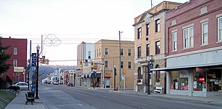
Fayetteville is a town in and the county seat of Fayette County, West Virginia, United States. The population was 2,887 at the 2020 census.
West Milford is a town in Harrison County, West Virginia, United States. The population was 452 at the 2020 census.
Chesapeake is a town in Kanawha County, West Virginia, United States. The population was 1,336 at the 2020 census. The town is situated on the Kanawha River.
West Hamlin is a town in Lincoln County, West Virginia, United States, along the Guyandotte River. The population was 519 at the 2020 census, and is now down to 509, according to the 2021 census. West Hamlin is a part of the Huntington-Ashland, WV-KY-OH, Metropolitan Statistical Area (MSA). West Hamlin is west of the county seat at Hamlin, hence the name.
Worthington is a town in Marion County, West Virginia, United States. The population was 158 at the 2010 census. Worthington was incorporated in 1893 and named for Colonel George Worthington, an early settler. U.S. Route 19 passes through the town.
Glen Dale is a city in Marshall County, West Virginia, United States, along the Ohio River. It is part of the Wheeling, West Virginia Metropolitan Statistical Area. The population was 1,514 at the 2020 census. Glen Dale was incorporated in 1924. It is in the northwest part of the county, which is above the Mason–Dixon line and forms the base of the Northern Panhandle of West Virginia.
Anawalt is a town in McDowell County, West Virginia, United States. At one time it was known as Jeanette. It is named in honor of James White Anawalt, who was then manager of Union Supply Company, a subsidiary of the United States Steel Company. The population was 186 at the 2020 census. Coal mining was the town's chief industry.
Iaeger is a town in McDowell County, West Virginia, United States. The population was 257 at the 2020 census.
West Liberty is a town in Ohio County, West Virginia, United States. The population was 1,557 at the 2020 census. It is part of the Wheeling metropolitan area.
St. Marys is a city and the county seat of Pleasants County, West Virginia, United States. The population was 1,847 at the 2020 census. It is part of the Parkersburg–Vienna metropolitan area. St. Marys was established in 1849 by Alexander Creel, who is said to have had a vision of Mary while passing the townsite by boat on the Ohio River.
Brandonville is a town in northern Preston County, West Virginia, United States. The population was 136 at the 2020 census. It is part of the Morgantown metropolitan area.
Mabscott is a town in Raleigh County, West Virginia, United States. The population was 1,333 at the 2020 census. The town's name is a contraction of the name Mabel Scott, wife of local coal operator Cyrus H. Scott.
Pennsboro is a city in Ritchie County, West Virginia, United States. The population was 1,050 at the 2020 census. The city is located at the junction of U.S. Route 50 and West Virginia Route 74; the North Bend Rail Trail also passes through the city.
Flemington is a town in Taylor County, West Virginia, United States. The population was 311 at the 2020 census. Flemington was incorporated in 1922 by the West Virginia Circuit Court, and named for James Fleming, an early settler in the area originally from Hampshire County.
Hendricks is a town in Tucker County, West Virginia, United States. The population was 226 at the 2020 census. The Blackwater River and the Dry Fork join at Hendricks to form the Black Fork, a principal tributary of the Cheat River.
Thomas is a city and former coal town in Tucker County, West Virginia, United States. The population was 623 at the 2020 census.
Middlebourne is a town and the county seat of Tyler County, West Virginia, United States. The population was 715 at the 2020 census.
Elizabeth is a town in and the county seat of Wirt County, West Virginia, United States, situated along the Little Kanawha River. The population was 724 as of the 2020 census.
Oceana is a town in Wyoming County, West Virginia. The population was 1,462 at the time of the 2020 census. Oceana is the oldest city in Wyoming County and was the county seat until 1907.