Paden City, West Virginia

Last updated

Paden City, West Virginia
Tyler County West Virginia Incorporated and Unincorporated areas Paden City Highlighted.svg
Location of Paden City in Tyler County, West Virginia.
Coordinates: 39°36′13″N80°56′1″W / 39.60361°N 80.93361°W / 39.60361; -80.93361
Country United States
State West Virginia
Counties Wetzel, Tyler
Area
[1]
  Total0.84 sq mi (2.19 km2)
  Land0.84 sq mi (2.19 km2)
  Water0.00 sq mi (0.00 km2)
Elevation
659 ft (201 m)
Population
 (2020) [2]
  Total2,550
  Estimate 
(2021) [2]
2,478
  Density2,764.50/sq mi (1,066.82/km2)
Time zone UTC-5 (Eastern (EST))
  Summer (DST) UTC-4 (EDT)
ZIP code
26159
Area code 304
FIPS code 54-61636 [3]
GNIS feature ID1555291 [4]
Website padencity.org

Paden City is a city in Tyler and Wetzel counties in the U.S. state of West Virginia, along the Ohio River. It was founded in 1902. The population was 2,550 at the 2020 census. [2]

Contents

History

The town was named for Pennsylvania-born Obediah Paden (1755-1822), a local landowner. [5] Nearby Paden Island and Paden Fork were also named for this individual, [6] and the entire region, when owned by Paden, was known as Paden's Bottom. [7]

The Paden City Pottery Company was established in 1911 by a European, John Lessel. He started his company there because Paden City had large clay deposits. At one time the company employed over 400 people. It made beautiful pottery and quality sets of dishes. It closed in 1950 but its products are still available for sale on many websites selling vintage dishware.

Geography

Paden City is located at 39°36′13″N80°56′1″W / 39.60361°N 80.93361°W / 39.60361; -80.93361 (39.603571, -80.933683). [8]

According to the United States Census Bureau, the city has a total area of 0.85 square miles (2.20 km2), all land. [9]

Demographics

Historical population
CensusPop.Note
1920 1,705
1930 2,28133.8%
1940 2,215−2.9%
1950 2,58816.8%
1960 3,13721.2%
1970 3,67417.1%
1980 3,671−0.1%
1990 2,862−22.0%
2000 2,860−0.1%
2010 2,633−7.9%
2020 2,550−3.2%
2021 (est.)2,478 [2] −2.8%
U.S. Decennial Census [10]

2010 census

As of the census [11] of 2010, there were 2,633 people, 1,143 households, and 775 families living in the city. The population density was 3,097.6 inhabitants per square mile (1,196.0/km2). There were 1,267 housing units at an average density of 1,490.6 per square mile (575.5/km2). The racial makeup of the city was 98.8% White, 0.2% African American, 0.2% Native American, 0.1% Asian, and 0.6% from two or more races. Hispanic or Latino of any race were 0.5% of the population.

There were 1,143 households, of which 26.0% had children under the age of 18 living in them, 52.1% were married couples living together, 11.5% had a female householder with no husband present, 4.2% had a male householder with no wife present, and 32.2% were non-families. 27.9% of all households were made up of individuals, and 15% had someone living alone who was 65 years of age or older. The average household size was 2.30 and the average family size was 2.76.

The median age in the city was 44.9 years. 20% of residents were under the age of 18; 7.2% were between the ages of 18 and 24; 22.8% were from 25 to 44; 28.1% were from 45 to 64; and 21.7% were 65 years of age or older. The gender makeup of the city was 47.7% male and 52.3% female.

2000 census

As of the census [3] of 2000, there were 2,860 people, 1,183 households, and 843 families living in the city. The population density was 3,228.4 people per square mile (1,240.7/km2). There were 1,300 housing units at an average density of 1,467.5 per square mile (564.0/km2). The racial makeup of the city was 99.34% White, 0.10% African American, 0.10% Native American, 0.10% Asian, and 0.35% from two or more races. Hispanic or Latino of any race were 0.49% of the population.

There were 1,183 households, out of which 29.4% had children under the age of 18 living in them, 58.1% were married couples living together, 9.6% had a female householder with no husband present, and 28.7% were non-families. 26.0% of all households were made up of individuals, and 15.6% had someone living alone who was 65 years of age or older. The average household size was 2.40 and the average family size was 2.86.

In the city, the population was spread out, with 23.3% under the age of 18, 6.6% from 18 to 24, 26.2% from 25 to 44, 25.3% from 45 to 64, and 18.6% who were 65 years of age or older. The median age was 41 years. For every 100 females, there were 89.8 males. For every 100 females age 18 and over, there were 86.6 males.

The median income for a household in the city was $32,940, and the median income for a family was $38,510. Males had a median income of $37,460 versus $18,750 for females. The per capita income for the city was $19,498. About 12.8% of families and 15.1% of the population were below the poverty line, including 20.7% of those under age 18 and 13.4% of those age 65 or over.

Notable people

See also

Related Research Articles

<span class="mw-page-title-main">Wetzel County, West Virginia</span> County in West Virginia, United States

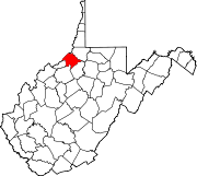
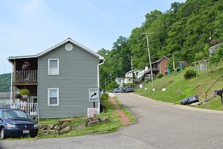
Wetzel County is a county in the U.S. state of West Virginia. As of the 2020 census, the population was 14,442. Its county seat is New Martinsville. The county, founded in 1846, is named for Lewis Wetzel, a famous frontiersman and Indian fighter. Its northern border aligns with the Mason-Dixon line, but is to the west of the line's western terminus.

<span class="mw-page-title-main">Clifton, Illinois</span> Village in Illinois, United States

Clifton is a village in Chebanse Township, Iroquois County, Illinois, United States. The population was 1,468 at the 2010 census, up from 1,317 at the 2000 census.

<span class="mw-page-title-main">Carson, Iowa</span> City in Iowa, United States

Carson is a city in Pottawattamie County, Iowa, United States. The population was 766 at the 2020 census. Carson has a number of interesting and historic places.

<span class="mw-page-title-main">Macedonia, Iowa</span> City in Iowa, United States

Macedonia is a city in Pottawattamie County, Iowa, United States. The population was 267 at the time of the 2020 census.

<span class="mw-page-title-main">Lyndon, Kansas</span> City in Osage County, Kansas

Lyndon is a city in, and the county seat of Osage County, Kansas, United States. As of the 2020 census, the population of the city was 1,037.

<span class="mw-page-title-main">Alna, Maine</span> Town in the state of Maine, United States

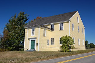
Alna is a town in Lincoln County, Maine, United States. The population was 710 at the 2020 census. Alna is home to the Wiscasset, Waterville and Farmington Railway Museum and is noted for its historic architecture, including the early mill village of Head Tide.

<span class="mw-page-title-main">Lenox Township, Michigan</span> Civil township in Michigan, United States

Lenox Township is a civil township of Macomb County in the U.S. state of Michigan. As of the 2020 census, the population was 12,119, up from 10,470 in 2010.

<span class="mw-page-title-main">Zilwaukee, Michigan</span> City in Michigan, United States

Zilwaukee is a city in Saginaw County in the U.S. state of Michigan. The 2020 census places the population at 1,534. The city is adjacent to and was created from Zilwaukee Township. It is the home of the Zilwaukee Bridge.

<span class="mw-page-title-main">Rose Creek, Minnesota</span> City in Minnesota, United States

Rose Creek is a city in Mower County, Minnesota, United States. The population was 397 at the 2020 census.

<span class="mw-page-title-main">Iron Junction, Minnesota</span> City in Minnesota, United States

Iron Junction is a city in Saint Louis County, Minnesota, United States. The population was 110 at the 2020 census.

<span class="mw-page-title-main">Paden, Mississippi</span> Village in Mississippi, United States

Paden is a village in Tishomingo County, Mississippi, United States. The population was 116 at the 2010 census.

<span class="mw-page-title-main">Clyde Park, Montana</span> Town in Montana, United States

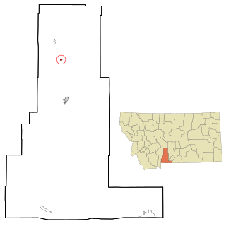
Clyde Park is a town in Park County, Montana, United States. The population was 332 at the 2020 census. Originally known as Sunnyside, the town was renamed in the 1890s.

<span class="mw-page-title-main">Sutcliffe, Nevada</span> CDP in Nevada, United States

Sutcliffe is a census-designated place (CDP) in Washoe County, Nevada, United States. The population was 253 at the 2010 census. It is part of the Reno–Sparks Metropolitan Statistical Area.

Nelliston is a village in Montgomery County, New York, United States. The population was 596 at the 2010 census. The name is from members of the Nellis family.

<span class="mw-page-title-main">Gascoyne, North Dakota</span> City in North Dakota, United States

Gascoyne is a city in Bowman County, North Dakota, United States. The population was 21 at the 2020 census.

<span class="mw-page-title-main">Clarington, Ohio</span> Village in Ohio, United States

Clarington is a village in Monroe County, Ohio, United States, along the Ohio River. The population was 280 at the 2020 census.

<span class="mw-page-title-main">Paden, Oklahoma</span> Town in Oklahoma, United States

Paden is a town in Okfuskee County, Oklahoma, United States. The population was 419 at the 2020 Census. It is named for Paden Tolbert, a U.S. Deputy Marshal who served the area in the early 1900s.

<span class="mw-page-title-main">Leechburg, Pennsylvania</span> Borough in Pennsylvania, United States

Leechburg is a borough in southern Armstrong County in the U.S. state of Pennsylvania, 35 miles (56 km) northeast of Pittsburgh. A population of 2,149 residents live within the borough limits as of the 2020 census, according to United States Census Bureau. Leechburg was founded by David Leech, for whom it was named, and was incorporated as a borough in 1850.

<span class="mw-page-title-main">Belmont, West Virginia</span> Town in West Virginia, United States

Belmont is a town in Pleasants County, West Virginia, United States. It is part of the Parkersburg–Vienna metropolitan area. The population was 872 at the 2020 census. Belmont was incorporated on April 19, 1946 by the Circuit Court of Pleasants County. The city was named for the beautiful hills in the area.

<span class="mw-page-title-main">New Martinsville, West Virginia</span> City in West Virginia, United States

New Martinsville is a city in and the county seat of Wetzel County, West Virginia, United States, along the Ohio River. The population was 5,186 at the 2020 census.

References

  1. "2019 U.S. Gazetteer Files". United States Census Bureau. Retrieved August 7, 2020.
  2. 1 2 3 4 "City and Town Population Totals: 2020-2021". Census.gov. US Census Bureau. Retrieved July 2, 2022.
  3. 1 2 "U.S. Census website". United States Census Bureau . Retrieved January 31, 2008.
  4. "US Board on Geographic Names". United States Geological Survey. October 25, 2007. Retrieved January 31, 2008.
  5. Kenny, Hamill (1945). West Virginia Place Names: Their Origin and Meaning, Including the Nomenclature of the Streams and Mountains. Piedmont, WV: The Place Name Press. p. 467.; Randy Rutherford, 'The Good Old Days: Obediah Paden' Wetzel Chronicle 22 December 2021, https://www.wetzelchronicle.com/news/your-community/2021/12/22/the-good-old-days-obediah-paden/
  6. 'New Town Booming' Sistersville Oil Review, 15 August 1903 p.1
  7. Randy Rutherford, 'The Good Old Days: Obediah Paden' Wetzel Chronicle 22 December 2021, https://www.wetzelchronicle.com/news/your-community/2021/12/22/the-good-old-days-obediah-paden/
  8. "US Gazetteer files: 2010, 2000, and 1990". United States Census Bureau. February 12, 2011. Retrieved April 23, 2011.
  9. "US Gazetteer files 2010". United States Census Bureau. Archived from the original on January 25, 2012. Retrieved January 24, 2013.
  10. "Census of Population and Housing". Census.gov. Retrieved June 4, 2015.
  11. "U.S. Census website". United States Census Bureau . Retrieved January 24, 2013.