Farmington, West Virginia

Last updated

Farmington, West Virginia
Town
Logo of Farmington, West Virginia.png
Motto: 
"The Heart of Marion County" [1]
Marion County West Virginia incorporated and unincorporated areas Farmington highlighted.svg
Location of Farmington in Marion County, West Virginia
USA West Virginia location map.svg
Red pog.svg
Farmington
Usa edcp location map.svg
Red pog.svg
Farmington
Coordinates: 39°30′47″N80°15′7″W / 39.51306°N 80.25194°W / 39.51306; -80.25194
CountryUnited States
State West Virginia
County Marion
Government
  TypeTown Council
  MayorBill Glasscock
Area
[2]
  Total0.43 sq mi (1.11 km2)
  Land0.41 sq mi (1.08 km2)
  Water0.01 sq mi (0.03 km2)
Elevation
932 ft (284 m)
Population
 (2020) [3]
  Total389
  Estimate 
(2021) [3]
403
  Density879.52/sq mi (339.28/km2)
Time zone UTC-5 (Eastern (EST))
  Summer (DST) UTC-4 (EDT)
ZIP code
26571
Area code 304
FIPS code 54-26932 [4]
GNIS feature ID1554446 [5]
Website https://www.townoffarmingtonwv.com/

Farmington is a town in Marion County, West Virginia, United States. The population was 389 at the 2020 census. [3] The small town is situated on Buffalo Creek and the Allegheny Mountains about 6 miles west of Fairmont, Marion County's county seat. [6] It is best known for being the site of the 1968 Farmington Mine disaster.

Contents

History

The community was named for the fact a large share of the first settlers were farmers. [7] The area was first settled by James Goodin in the late 1700s, by Nicholas Wood and family, and by Jacob Straight and family in the 1770s. A later settler, Joseph Morgan, would build a mill here in 1801. The area would later be incorporated in Marion County as the town of Farmington in 1896, but was earlier known as Willeyvile, Willeytown, and Underwood. While it was officially named Farmington in 1896, when the Baltimore and Ohio Railroad ran through the town its stations there went under the name Underwood because of there being many towns of the same name. The town was close to mine Number 08 of Jamison Coal and Coke Company. The mine exploded in 1926 and was sealed in the 1940s. The town is also close to mine Number 09 of Consolidated Coal Company, which is the site of the 1968 Farmington Mine disaster that killed 78 people. The mine had previously exploded in 1954 and was eventually sealed in 1978.

Education

For public education, the town is part of Marion County Schools, which covers all of Marion County. Preschool through grade three attend Fairview Elementary School and grades four through eight attend Fairview Middle School, both in nearby Fairview, while students in grades nine through twelve attend North Marion High School, which is located approximately 2 miles (3.2 km) east of Farmington on US Route 250 and has a Farmington mailing address. Adjacent to North Marion High School is the Marion County Technical Center, which houses vocational and career tech programs available to high school students from the entire district. [8]

Prior to 1975, Farmington had its own high school, Farmington High School. [9] Athletic teams were known as the Farmers. It was closed due to structural issues caused by mine subsidence, which affected several other properties in town during the 1970s. [10] North Marion opened four years later as a consolidation of the remaining surrounding high schools.

Geography

Farmington is located at 39°30′47″N80°15′7″W / 39.51306°N 80.25194°W / 39.51306; -80.25194 (39.512979, -80.252060), [11] along Buffalo Creek. [12]

According to the United States Census Bureau, the town has a total area of 0.43 square miles (1.11 km2), of which 0.42 square miles (1.09 km2) is land and 0.01 square miles (0.03 km2) is water. [13]

Demographics

Historical population
CensusPop.Note
1870 89
1880 179101.1%
1910 519
1920 67930.8%
1930 81920.6%
1940 8807.4%
1950 824−6.4%
1960 709−14.0%
1970 595−16.1%
1980 583−2.0%
1990 414−29.0%
2000 387−6.5%
2010 375−3.1%
2020 3893.7%
2021 (est.)403 [3] 3.6%
U.S. Decennial Census [14]

2010 census

As of the census [15] of 2010, there were 375 people, 163 households, and 111 families living in the town. The population density was 892.9 inhabitants per square mile (344.8/km2). There were 192 housing units at an average density of 457.1 per square mile (176.5/km2). The racial makeup of the town was 97.9% White, 0.3% Asian, and 1.9% from two or more races. Hispanic or Latino of any race were 0.3% of the population.

There were 163 households, of which 30.7% had children under the age of 18 living with them, 51.5% were married couples living together, 9.8% had a female householder with no husband present, 6.7% had a male householder with no wife present, and 31.9% were non-families. 28.8% of all households were made up of individuals, and 13.5% had someone living alone who was 65 years of age or older. The average household size was 2.30 and the average family size was 2.80.

The median age in the town was 39.6 years. 21.9% of residents were under the age of 18; 5.2% were between the ages of 18 and 24; 31.4% were from 25 to 44; 24.3% were from 45 to 64; and 17.1% were 65 years of age or older. The gender makeup of the town was 49.9% male and 50.1% female.

2000 census

As of the census [4] of 2000, there were 387 people, 163 households, and 108 families living in the town. The population density was 917.3 inhabitants per square mile (355.8/km2). There were 194 housing units at an average density of 459.8 per square mile (178.3/km2). The racial makeup of the town was 96.90% White, 1.81% African American, and 1.29% from two or more races.

There were 163 households, out of which 26.4% had children under the age of 18 living with them, 42.9% were married couples living together, 17.2% had a female householder with no husband present, and 33.7% were non-families. 30.1% of all households were made up of individuals, and 19.0% had someone living alone who was 65 years of age or older. The average household size was 2.37 and the average family size was 2.93.

In the town, the population was spread out, with 23.5% under the age of 18, 7.0% from 18 to 24, 27.4% from 25 to 44, 23.0% from 45 to 64, and 19.1% who were 65 years of age or older. The median age was 37 years. For every 100 females, there were 85.2 males. For every 100 females age 18 and over, there were 81.6 males.

The median income for a household in the town was $29,375, and the median income for a family was $39,688. Males had a median income of $31,250 versus $18,750 for females. The per capita income for the town was $15,990. About 5.9% of families and 9.0% of the population were below the poverty line, including 17.3% of those under age 18 and 1.3% of those age 65 or over.

Notable people

See also

Related Research Articles

<span class="mw-page-title-main">Marion County, West Virginia</span> County in West Virginia, United States

Marion County is a county in the U.S. state of West Virginia. As of the 2020 census, the population was 56,205. Its county seat is Fairmont. The county was named in honor of General Francis Marion, known to history as "The Swamp Fox".

<span class="mw-page-title-main">Marion County, Ohio</span> County in Ohio, United States

Marion County is a county located in the U.S. state of Ohio. As of the 2020 census, the population was 65,359. Its county seat is Marion. The county was created in 1820 and later organized in 1824. It is named for General Francis "The Swamp Fox" Marion, a South Carolinian officer in the Revolutionary War.

<span class="mw-page-title-main">Fairview, Alabama</span> Town in Alabama, United States

Fairview is a town in Cullman County, Alabama, United States. At the 2010 census the population was 446, down from 522 in 2000. It incorporated in 1968.

<span class="mw-page-title-main">Ravenden, Arkansas</span> Town in Arkansas, United States

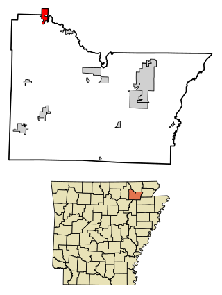
Ravenden is a town in Lawrence County, Arkansas, United States. The population was 470 at the 2010 census. The town is in the valley of the Spring River along U.S. Highway 63 and the Burlington-Northern Railroad.

<span class="mw-page-title-main">Farmington, Delaware</span> Town in Delaware, United States

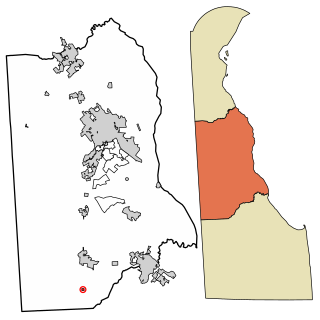
Farmington is a town in Kent County, Delaware, United States. It is part of the Dover, Delaware Metropolitan Statistical Area. The population was 92 in 2020.

<span class="mw-page-title-main">Fairview Heights, Illinois</span> City in Illinois, United States

Fairview Heights is a city in St. Clair County, Illinois, United States within Greater St. Louis. It is an eastern suburb of St. Louis. The population was 17,078 at the 2010 census. Fairview Heights is a dominant shopping center for Greater St. Louis and Southern Illinois and includes numerous shopping plazas and St. Clair Square mall.

<span class="mw-page-title-main">Bussey, Iowa</span> City in Iowa, United States

Bussey is a city in southeast Marion County, Iowa, United States. The population was 387 at the time of the 2020 census.

<span class="mw-page-title-main">Farmington, Iowa</span> City in Iowa, United States

Farmington is a city in Van Buren County, Iowa, United States. The population was 579 at the time of the 2020 census.

<span class="mw-page-title-main">Fairview, Missouri</span> City in Missouri, United States

Fairview is a city in southeastern Newton County, Missouri, United States. The population was 383 at the 2010 census. It is part of the Joplin, Missouri Metropolitan Statistical Area.

<span class="mw-page-title-main">Farmington, Missouri</span> City in Missouri, United States

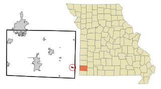
Farmington is a city in St. Francois County located about 75 miles (121 km) southwest of St. Louis in the Lead Belt region in Missouri. As of the 2020 census, the population was 18,217. It is the county seat of St. Francois County. Farmington was established in 1822 as Murphy's Settlement, named for William Murphy of Kentucky, who first visited the site in 1798. When St. Francois County was organized, the town was briefly called St. Francois Court House and later renamed to Farmington.

<span class="mw-page-title-main">Fairview, Montana</span> Town in Montana, United States

Fairview is a town in Richland County, Montana, United States. The population was 896 at the 2020 census. The town is directly on the North Dakota border. Fairview incorporated in 1913.

<span class="mw-page-title-main">Fairview, Oklahoma</span> City in Oklahoma, United States

Fairview is a city in Major County, Oklahoma, United States. The population was 2,740 at the time of the 2020 Census. It is the county seat of Major County.

<span class="mw-page-title-main">Fairview Township, Butler County, Pennsylvania</span> Township in Pennsylvania, United States

Fairview Township is a township in Butler County, Pennsylvania, United States. The population was 1,942 at the 2020 census.

<span class="mw-page-title-main">Branchville, South Carolina</span> Town in South Carolina, United States

Branchville is a town in Orangeburg County, South Carolina, United States. The population was 1,024 at the 2010 census.

<span class="mw-page-title-main">Doyle, Tennessee</span> Town in Tennessee, United States

Doyle is a town in White County, Tennessee, United States. The population was 537 at the 2010 census.

<span class="mw-page-title-main">Fairview, West Virginia</span> Town in West Virginia, United States

Fairview is a town in Marion County, West Virginia, United States. The population was 374 at the 2020 census.

<span class="mw-page-title-main">Monongah, West Virginia</span> Town in West Virginia, United States

Monongah is a town in Marion County, West Virginia, United States, situated where Booths Creek flows into the West Fork River. The population was 972 at the 2020 census. Monongah was chartered in 1891, based on Chapter 47 of West Virginia code. Its name is derived from the nearby Monongahela River.

<span class="mw-page-title-main">Farmington, Jefferson County, Wisconsin</span> Town in Wisconsin, United States

Farmington is a town in Jefferson County, Wisconsin, United States. The population as of the 2010 census was 1,380.

<span class="mw-page-title-main">Fairview, Ohio</span> Village in Ohio, United States

Fairview is a village in Belmont and Guernsey counties in the U.S. state of Ohio. The population was 67 as of the 2020 census. It is part of the Wheeling metropolitan area.

<span class="mw-page-title-main">Fairview Township, Fulton County, Illinois</span> Township in Illinois, United States

Fairview Township is one of 26 townships in Fulton County, in the U.S. state of Illinois. As of the 2020 census, its population was 596 and it contained 285 housing units.

References

  1. https://www.townoffarmingtonwv.com/ [ bare URL ]
  2. "2019 U.S. Gazetteer Files". United States Census Bureau. Retrieved August 7, 2020.
  3. 1 2 3 4 Bureau, US Census. "City and Town Population Totals: 2020-2021". Census.gov. US Census Bureau. Retrieved July 3, 2022.
  4. 1 2 "U.S. Census website". United States Census Bureau . Retrieved January 31, 2008.
  5. "US Board on Geographic Names". United States Geological Survey. October 25, 2007. Retrieved January 31, 2008.
  6. Burkett, Connie. "Marion County WVGenWeb". Marion County, WV.
  7. Kenny, Hamill (1945). West Virginia Place Names: Their Origin and Meaning, Including the Nomenclature of the Streams and Mountains. Piedmont, WV: The Place Name Press. p. 239.
  8. "Attendance Areas". Marion County Schools. June 7, 2010. Retrieved February 6, 2024.
  9. Hrin, Eric (July 29, 2018). "Farmington High School alumni gather for 18th homecoming". Times West Virginian. Retrieved February 6, 2024.
  10. "Alternatives To Protect Property Owners From Damages Caused By Mine Subsidence" (PDF). Comptroller General of the United States. February 14, 1979. pp. 20–21. Retrieved February 6, 2024.
  11. "US Gazetteer files: 2010, 2000, and 1990". United States Census Bureau. February 12, 2011. Retrieved April 23, 2011.
  12. West Virginia Atlas & Gazetteer. Yarmouth, Me.: DeLorme. 1997. p. 25. ISBN   0-89933-246-3.
  13. "US Gazetteer files 2010". United States Census Bureau. Archived from the original on January 25, 2012. Retrieved January 24, 2013.
  14. "Census of Population and Housing". Census.gov. Retrieved June 4, 2015.
  15. "U.S. Census website". United States Census Bureau . Retrieved January 24, 2013.