Mount Hope, West Virginia

Last updated

Mount Hope, West Virginia
Mount Hope West Virginia.jpg
Main Street (West Virginia Route 211) in Mount Hope in 2007
Flag of Mount Hope, West Virginia.svg
Motto: 
Gateway to the Summit
Fayette County West Virginia Incorporated and Unincorporated areas Mount Hope Highlighted.svg
Location of Mount Hope in Fayette County, West Virginia.
Coordinates: 37°53′33″N81°10′4″W / 37.89250°N 81.16778°W / 37.89250; -81.16778
Country United States
State West Virginia
County Fayette
Government
  MayorMichael Kessigner
Area
[1]
  Total1.56 sq mi (4.03 km2)
  Land1.56 sq mi (4.03 km2)
  Water0.00 sq mi (0.00 km2)
Elevation
1,722 ft (525 m)
Population
 (2010) [2]
  Total1,414
  Estimate 
(2019) [3]
1,274
  Density818.24/sq mi (315.97/km2)
Time zone UTC-5 (Eastern (EST))
  Summer (DST) UTC-4 (EDT)
ZIP code
25880
Area code 304
FIPS code 54-56404 [4]
GNIS feature ID1543656 [5]
Website mthopewv.org

Mount Hope is a city in Fayette County, West Virginia, United States. The population was 1,414 at the 2010 census.

Contents

History

Early settlers came to Mount Hope to begin mining coal. Coal miners in Mount Hope continued to thrive for about 250 years, but ending due to the rise of mining in the Mid-west and closing entirely during the depression.

Prior to the arrival of Europeans in Mount Hope, the land was used primarily by Native Americans for centuries until William Blake, Sr. became the first white settler in the area. During this time Blake built a Hotel, The Old Blake Inn, in order to house travelers and coal miners on their way through Mount Hope. Between the 1890s and 1930s, Mount Hope's population and economy were booming. Until a Tragic fire (The Mount Hope Fire) occurred in 1910, destroying the majority of the town, Including the Old Blake Inn, and leaving only a few buildings standing.

With the help of the town, Mount Hope had been rebuilt, the Old Blake Inn was completely destroyed but another Inn was built in its place and managed to reopen under the name "Hotel Mount Hope" and became a hot spot for the miners in the area. At this time, Mount Hope continued to prosper. But it did not last long. The population of Mount Hope started to decline due to the start of the Great Depression. Unfortunately, The town Mount Hope had a hard time recovering from the Depression. Hotel Mount Hope shut down and opened again as the "New River Hotel", a hotel for businessmen traveling through the town. The Hotel was completely renovated at this time and opened under yet another name "The Mountainair Hotel". But inevitably closed again.

Today, Mount Hope's population continues to decline, leaving it much of a ghost town. The Hotel had been left vacant for some time but has since been bought and renamed the "Cottle Mountainair" by Joyce and Harvey Cottle, who have spent their time and dedication to renovate and reopen the Hotel as a space for family and community to come together. Joyce and Harvey currently rent out a room on the First floor to "Heart to Hands The Serendipity Shop [6] ", a local reiki and holistic shop that occasionally hosts events inside of the hotel.


The community took its name from the local Mount Hope School. [7]

The Mount Hope Historic District and New River Company General Office Building are listed on the National Register of Historic Places. [8]

Geography

Mount Hope is located at 37°53′33″N81°10′4″W / 37.89250°N 81.16778°W / 37.89250; -81.16778 (37.892595, -81.167687). [9]

According to the United States Census Bureau, the city has a total area of 1.33 square miles (3.44 km2), all land. [10]

The Summit

A parcel of land, totaling 10,600 acres (43 km2) of property known locally as Garden Ground was donated by the Bechtel Foundation to the Boy Scouts of America for development into The Summit: Bechtel Family National Scout Reserve, a high adventure base and site for the national Scout jamboree. [11] [12]

Demographics

Historical population
CensusPop.Note
1900 351
1910 49440.7%
1920 1,989302.6%
1930 2,36118.7%
1940 2,4313.0%
1950 2,5886.5%
1960 2,000−22.7%
1970 1,829−8.5%
1980 1,8491.1%
1990 1,573−14.9%
2000 1,487−5.5%
2010 1,414−4.9%
2019 (est.)1,274 [3] −9.9%
U.S. Decennial Census [13]

2010 census

As of the census [2] of 2010, there were 1,414 people, 626 households, and 362 families living in the city. The population density was 1,063.2 inhabitants per square mile (410.5/km2). There were 737 housing units at an average density of 554.1 per square mile (213.9/km2). The racial makeup of the city was 77.0% White, 18.0% African American, 0.5% Native American, 0.4% Asian, 0.4% from other races, and 3.7% from two or more races. Hispanic or Latino of any race were 1.6% of the population.

There were 626 households, of which 30.0% had children under the age of 18 living with them, 34.7% were married couples living together, 16.8% had a female householder with no husband present, 6.4% had a male householder with no wife present, and 42.2% were non-families. 37.1% of all households were made up of individuals, and 12% had someone living alone who was 65 years of age or older. The average household size was 2.26 and the average family size was 2.95.

The median age in the city was 37.5 years. 24.8% of residents were under the age of 18; 9.1% were between the ages of 18 and 24; 25.4% were from 25 to 44; 26.1% were from 45 to 64; and 14.6% were 65 years of age or older. The gender makeup of the city was 47.6% male and 52.4% female.

2000 census

As of the census [4] of 2000, there were 1,487 people, 635 households, and 419 families living in the city. The population density was 1,142.9 people per square mile (441.6/km2). There were 750 housing units at an average density of 576.4 per square mile (222.8/km2). The racial makeup of the city was 73.77% White, 22.33% African American, 0.34% Native American, 0.07% Asian, 0.27% Pacific Islander, 0.94% from other races, and 2.29% from two or more races. Hispanic or Latino of any race were 1.41% of the population.

There were 635 households, out of which 31.0% had children under the age of 18 living with them, 38.1% were married couples living together, 23.9% had a female householder with no husband present, and 34.0% were non-families. 30.2% of all households were made up of individuals, and 15.9% had someone living alone who was 65 years of age or older. The average household size was 2.34 and the average family size was 2.87.

In the city, the population was spread out, with 27.2% under the age of 18, 8.5% from 18 to 24, 24.6% from 25 to 44, 23.7% from 45 to 64, and 16.0% who were 65 years of age or older. The median age was 37 years. For every 100 females, there were 82.2 males. For every 100 females age 18 and over, there were 76.2 males.

The median income for a household in the city was $18,375, and the median income for a family was $23,333. Males had a median income of $25,833 versus $16,500 for females. The per capita income for the city was $11,147. About 35.1% of families and 36.0% of the population were below the poverty line, including 57.3% of those under age 18 and 7.1% of those age 65 or over.

Notable people

Related Research Articles

<span class="mw-page-title-main">Little Sioux, Iowa</span> City in Iowa, United States

Little Sioux is a city in Harrison County, Iowa, United States. The population was 166 at the time of the 2020 census. The city is most known for Little Sioux Scout Ranch of the Boy Scouts of America.

<span class="mw-page-title-main">Mount Union, Iowa</span> Census-designated place in Iowa, United States

Mount Union is an unincorporated community and census-designated place (CDP) in Henry County, Iowa, United States. It was formerly a city, but in a November 2016 referendum residents voted 32 to 31 to unincorporate. The 2010 census reported the city population to be 107.

<span class="mw-page-title-main">Delphos, Iowa</span> City in Iowa, United States

Delphos is a former city in Ringgold County, Iowa, United States. The population was 26 at the 2020 census. In 2017 the community of Delphos voted to disincorporate. This was approved by the Ringgold County Board of Supervisors in 2018.

<span class="mw-page-title-main">Redding, Iowa</span> City in Iowa, United States

Redding is a city in southwest Ringgold County, Iowa, United States. The population was 63 at the time of the 2020 census.

<span class="mw-page-title-main">Culver, Kansas</span> City in Ottawa County, Kansas

Culver is a city in Ottawa County, Kansas, United States. As of the 2020 census, the population of the city was 114. It is located northwest of Salina at the intersection of 90th Road and Aspen Road, next to an abandoned railroad.

<span class="mw-page-title-main">Mount Hope, Kansas</span> City in Sedgwick County, Kansas

Mount Hope is a city in Sedgwick County, Kansas, United States. As of the 2020 census, the population of the city was 806.

<span class="mw-page-title-main">Mount Vernon, Maine</span> Town in the state of Maine, United States

Mount Vernon is a town in Kennebec County, Maine, United States. The population was 1,721 at the 2020 census. Mount Vernon is included in the Augusta, Maine micropolitan New England City and Town Area. A popular recreation spot in central Maine, the northern area of Mount Vernon is part of the Belgrade Lakes Region, while the southern area is part of the Winthrop Lakes Region.

<span class="mw-page-title-main">Mount Morris, Michigan</span> City in Michigan, United States

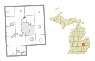
Mount Morris is a city in Genesee County in the U.S. state of Michigan. The population was 3,086 at the 2010 census. The city is bordered by Mount Morris Township on the west and Genesee Township on the east. It was named after Mount Morris, New York, because many of the early settlers had come from there. It is part of the Flint metropolitan area.

<span class="mw-page-title-main">Grove City, Minnesota</span> City in Minnesota, United States

Grove City is a city in Meeker County, Minnesota, United States. The population was 624 at the 2020 census.

<span class="mw-page-title-main">Strathcona, Minnesota</span> City in Minnesota, United States

Strathcona is a city in Roseau County, Minnesota, United States. The population was 44 at the 2010 census.

<span class="mw-page-title-main">Mount Vernon, Missouri</span> City in Missouri, United States

Mount Vernon is a city in and the county seat of Lawrence County, Missouri, United States. The population was 4,575 as of the 2010 census. It was estimated to be 4,960 by the City of Mount Vernon on July 1, 2020.

<span class="mw-page-title-main">Pillsbury, North Dakota</span> City in North Dakota, United States

Pillsbury is a city in Barnes County, North Dakota, United States. The population was 12 at the 2020 census. Pillsbury was founded in 1911.

<span class="mw-page-title-main">Hope, North Dakota</span> City in North Dakota, United States

Hope is a city in Steele County, North Dakota, United States. The population was 272 at the 2020 census. Hope was founded in 1881.

<span class="mw-page-title-main">Happy Valley, Oregon</span> City in Oregon, United States

Happy Valley is a suburban city in the Portland, Oregon metropolitan area. Happy Valley is near the northwest edge of Clackamas County, Oregon, United States approximately 10 miles to the southeast of downtown Portland, Oregon. The population was 23,733 at the 2020 census.

<span class="mw-page-title-main">Penn Township, Lancaster County, Pennsylvania</span> Township in Pennsylvania, United States

Penn Township is a township that is located in north central Lancaster County, Pennsylvania, United States. The population was 10,224 at the time of the 2020 census.

<span class="mw-page-title-main">Mount Vernon, South Dakota</span> City in South Dakota, United States

Mount Vernon is a city in Davison County, South Dakota, United States. The population was 461 at the 2020 census. It is part of the Mitchell, South Dakota Micropolitan Statistical Area.

<span class="mw-page-title-main">West Longview, Washington</span> Unincorporated community in Washington, United States

West Longview is an unincorporated community, which was formerly categorized as a census-designated place (CDP), in Cowlitz County, Washington. West Longview is located on western border of the city of Longview, Washington. When it was a categorized as a CDP, the population was 2,882 according to the 2000 United States Census.

<span class="mw-page-title-main">Blooming Grove, Wisconsin</span> Town in Wisconsin, United States

Blooming Grove is a town in Dane County, Wisconsin, United States. The population was 1,768 at the 2000 census. The unincorporated community of Hope is located partially within Blooming Grove. Although once much larger, currently the town of Blooming Grove consists of a few scattered neighborhoods and individual properties broken into discontinuous sections by the cities of Madison and Monona. Blooming Grove is set to be dissolved and annexed into the city of Madison by 2027.

<span class="mw-page-title-main">Ladysmith, Wisconsin</span> City in Wisconsin, United States

Ladysmith is a city and the county seat of Rusk County, Wisconsin, United States. The population was 3,216 at the 2020 census.

<span class="mw-page-title-main">Mount Hope, Wisconsin</span> Village in Wisconsin, United States

Mount Hope is a village in Grant County, Wisconsin, United States. The population was 225 at the 2010 census. The village is located within the Town of Mount Hope.

References

  1. "2019 U.S. Gazetteer Files". United States Census Bureau. Retrieved August 7, 2020.
  2. 1 2 "U.S. Census website". United States Census Bureau . Retrieved January 24, 2013.
  3. 1 2 "Population and Housing Unit Estimates". United States Census Bureau. May 24, 2020. Retrieved May 27, 2020.
  4. 1 2 "U.S. Census website". United States Census Bureau . Retrieved January 31, 2008.
  5. "US Board on Geographic Names". United States Geological Survey. October 25, 2007. Retrieved January 31, 2008.
  6. https://heartserendipityshop.wixsite.com/mysite?fbclid=IwZXh0bgNhZW0CMTAAAR2YJ1sUewnS3jkeohyG9GTWVIFR0AnY6OaXCZ-6fk6hDn7XM2w0FtV9qic_aem_AWV53iOKL6WyFvxjbVBlxcZBkZNDRmRI4xnYE3Yqa_joqE-epVrGIhiFYhsupcDTTlrGK6jo-aS-XOpmR0oVeypE
  7. Kenny, Hamill (1945). West Virginia Place Names: Their Origin and Meaning, Including the Nomenclature of the Streams and Mountains. Piedmont, WV: The Place Name Press. p. 432.
  8. "National Register Information System". National Register of Historic Places . National Park Service. July 9, 2010.
  9. "US Gazetteer files: 2010, 2000, and 1990". United States Census Bureau. February 12, 2011. Retrieved April 23, 2011.
  10. "US Gazetteer files 2010". United States Census Bureau. Archived from the original on July 2, 2012. Retrieved January 24, 2013.
  11. "The Summit: Bechtel Family National Scout Reserve" (PDF). Boy Scouts of America. Archived from the original (PDF) on July 10, 2012. Retrieved April 8, 2010.
  12. "Boy Scouts to Bring World-Class Center of Scouting Excellence to West Virginia". Boy Scouts of America. November 18, 2009. Archived from the original on June 22, 2011. Retrieved June 29, 2010.
  13. "Census of Population and Housing". Census.gov. Retrieved June 4, 2015.

Mount Hope Official Website