
Great Falls is a census-designated place (CDP) in Fairfax County, Virginia, United States. The population as of the 2010 census was 15,427, an increase of 80.5% from the 2000 census.

John Edward Thompson "Jackie" Milburn was a football player principally associated with Newcastle United and England, though he also spent four seasons at Linfield. He was also known as Wor Jackie and as the First World Wor.
Midland High School can refer to one of the following high schools:

Quick is a small unincorporated community in Kanawha County, West Virginia, United States. It is located along Indian Creek Road. The community is where Whitoak Fork and Blue Creek come together and meet. It is also where the abandoned railroad that follows Blue Creek joins the road, and follows it all the way to the community of Hitop, along Pond Fork. Its post office is closed.
Belva is an unincorporated community and census-designated place in west Nicholas County and north Fayette County, West Virginia, United States; while the CDP only includes the Nicholas County portion, the Fayette County portion is considered part of the community. The town is situated at the bottomland surrounding the convergence of Bells Creek with Twentymile Creek and, subsequently, Twenty Mile Creek with the Gauley River. Belva is also the location of the convergence of two state highways: West Virginia Route 16 and West Virginia Route 39.

The Tucker County Courthouse and Jail in Parsons, West Virginia was built between 1898 and 1900 in a combination of Flemish Renaissance and Romanesque Revival styles. The red pressed-brick structure is flanked by a "jail and jailer's residence" built in 1896 in a similar style.

Frank Pierce Milburn was a prolific American architect of the late 19th and early 20th centuries. His practice was primarily focused on public buildings, particularly courthouses and legislative buildings, although he also designed railroad stations, commercial buildings, schools and residences. Milburn was a native of Bowling Green, Kentucky who practiced as an architect in Louisville from 1884 to 1889; Kenova, West Virginia 1890-1895; Charlotte, North Carolina; Columbia, South Carolina; and Washington, D.C. after 1904. From 1902 Milburn was architect for the Southern Railway.
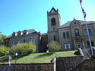
The McDowell County Courthouse is a historic courthouse in Welch, West Virginia. It was placed on the National Register of Historic Places on August 29, 1979.

The Putnam County Courthouse in Winfield, West Virginia was built in 1900 to replace an 1848 structure which partially collapsed in 1899. The Romanesque Revival building was designed by architect Frank Pierce Milburn with a hip roof and octagonal towers at all four corners. It is similar to the Summers County Courthouse in Hinton, West Virginia.
Beury is an unincorporated community and coal town in Fayette County, West Virginia.

Wickham is an unincorporated community in Raleigh County, West Virginia, United States. Its post office is closed.
Crickmer is an unincorporated community in Fayette County, West Virginia.
Weir is an unincorporated community in Kanawha County, West Virginia, United States. Its post office is called Falling Rock.
Legg is an unincorporated community in Kanawha County, West Virginia, United States. Its post office is closed.
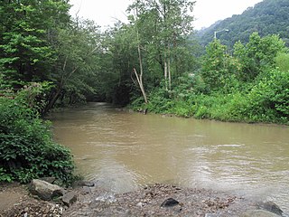
Paint Creek is a 42.1-mile (67.8 km) tributary of the Kanawha River in southern West Virginia. Paint Creek is part of the Mississippi River watershed via the Kanawha and Ohio Rivers and drains an area of 123 square miles (320 km2).
Glade is an unincorporated community in Fayette County, West Virginia. It was also known as Paw Paw.

Milburn is an unincorporated community in Carlisle County, Kentucky, United States. Its elevation is 482 feet (147 m), and it is located at 36°47′55″N88°53′59″W. Located along Kentucky Route 80 at its junction with Kentucky Routes 1371 and 1377, Milburn lies amid rolling countryside at the headwaters of Guess Creek, a tributary of Bayou du Chien; the nearest point on the Mississippi River is approximately 12 miles (19 km) to the west. Nearby cities include Arlington, 6 miles (9.7 km) by air to the west, and Bardwell, 8 miles (13 km) by air to the northwest; Milburn is connected to them by Kentucky Route 80 and Kentucky Route 1377 respectively. A state hunting preserve, the Obion Creek Wildlife Management Area, lies 2 miles (3.2 km) to the south. A fire station is located in Milburn, and a Creole cottage in the community, the George W. Stone House, is listed on the National Register of Historic Places.
Milburn Creek is a stream in the U.S. state of West Virginia.


