Oak Hill, West Virginia

Last updated

Oak Hill, West Virginia
Oak Hill West Virginia.jpg
Main Street (West Virginia Route 16) in downtown Oak Hill in 2007
Logo of Oak Hill, West Virginia.png
Motto: 
The Pride of the Plateau
Fayette County West Virginia Incorporated and Unincorporated areas Oak Hill Highlighted.svg
Location of Oak Hill in Fayette County, West Virginia.
Coordinates: 37°58′58″N81°8′43″W / 37.98278°N 81.14528°W / 37.98278; -81.14528
Country United States
State West Virginia
County Fayette
Government
   Mayor Charles H. Briscoe
   City Manager Damita Johnson
Area
[1]
  Total9.63 sq mi (24.94 km2)
  Land9.61 sq mi (24.90 km2)
  Water0.02 sq mi (0.04 km2)
Elevation
2,014 ft (614 m)
Population
 (2020) [2]
  Total8,179
  Density850/sq mi (330/km2)
Time zone UTC-5 (Eastern (EST))
  Summer (DST) UTC-4 (EDT)
ZIP code
25901
Area code 304
FIPS code 54-60028 [3]
GNIS feature ID1544297 [4]
Website https://oakhillwv.gov

Oak Hill is a city in Fayette County, West Virginia, United States. The population was 8,179 at the 2020 census. It is part of the Beckley metropolitan area.

Contents

Country singer Hank Williams died in Oak Hill on his way to a concert on January 1, 1953. The city is also home to the historic Oak Hill Railroad Depot which still stands today as an artisan shop. More recently, recreation has become a leading industry as the city neighbors the New River Gorge National Park and Preserve.

History

Oak Hill was settled in 1820. [5] The community was so named on account of an oak tree at the elevated town site. [6] It was incorporated as a town in 1905. [7]

Oak Hill is the supposed place of death of Hank Williams. According to his driver Charles Carr, they had stopped at a gas station in Oak Hill and found Williams dead in the backseat. On March 26, 2016, the city was honored with a historical marker to pay tribute to Williams' memory. [8]

Geography

Oak Hill is located at 37°58′58″N81°8′43″W / 37.98278°N 81.14528°W / 37.98278; -81.14528 (37.982775, -81.145334). [9]

According to the United States Census Bureau, the city has a total area of 4.89 square miles (12.67 km2), of which 4.88 square miles (12.64 km2) is land and 0.01 square miles (0.03 km2) is water. [10]

Climate

Climate data for Oak Hill, West Virginia (1991–2020 normals, extremes 1941–2012)
MonthJanFebMarAprMayJunJulAugSepOctNovDecYear
Record high °F (°C)74
(23)
76
(24)
86
(30)
89
(32)
92
(33)
95
(35)
99
(37)
98
(37)
98
(37)
93
(34)
85
(29)
79
(26)
99
(37)
Mean maximum °F (°C)62.8
(17.1)
65.9
(18.8)
73.8
(23.2)
81.7
(27.6)
83.5
(28.6)
86.9
(30.5)
88.7
(31.5)
88.8
(31.6)
85.7
(29.8)
78.8
(26.0)
73.7
(23.2)
63.4
(17.4)
90.0
(32.2)
Mean daily maximum °F (°C)40.7
(4.8)
44.2
(6.8)
52.3
(11.3)
64.3
(17.9)
71.5
(21.9)
78.5
(25.8)
81.3
(27.4)
80.6
(27.0)
75.4
(24.1)
65.2
(18.4)
54.2
(12.3)
44.6
(7.0)
62.7
(17.1)
Daily mean °F (°C)31.8
(−0.1)
34.4
(1.3)
41.7
(5.4)
52.7
(11.5)
60.6
(15.9)
68.0
(20.0)
71.3
(21.8)
70.4
(21.3)
64.8
(18.2)
53.8
(12.1)
43.8
(6.6)
35.8
(2.1)
52.4
(11.3)
Mean daily minimum °F (°C)22.8
(−5.1)
24.6
(−4.1)
31.2
(−0.4)
41.0
(5.0)
49.7
(9.8)
57.6
(14.2)
61.3
(16.3)
60.3
(15.7)
54.2
(12.3)
42.4
(5.8)
33.4
(0.8)
27.0
(−2.8)
42.1
(5.6)
Mean minimum °F (°C)1.6
(−16.9)
7.3
(−13.7)
15.2
(−9.3)
25.0
(−3.9)
34.0
(1.1)
43.8
(6.6)
50.5
(10.3)
49.7
(9.8)
38.1
(3.4)
27.3
(−2.6)
19.4
(−7.0)
7.3
(−13.7)
−2.7
(−19.3)
Record low °F (°C)−20
(−29)
−11
(−24)
−5
(−21)
13
(−11)
24
(−4)
33
(1)
40
(4)
39
(4)
26
(−3)
13
(−11)
0
(−18)
−15
(−26)
−20
(−29)
Average precipitation inches (mm)3.48
(88)
3.28
(83)
4.18
(106)
4.18
(106)
5.13
(130)
5.55
(141)
4.61
(117)
4.14
(105)
3.66
(93)
2.87
(73)
2.93
(74)
3.85
(98)
47.86
(1,216)
Average snowfall inches (cm)12.4
(31)
10.0
(25)
7.6
(19)
1.3
(3.3)
0.0
(0.0)
0.0
(0.0)
0.0
(0.0)
0.0
(0.0)
0.0
(0.0)
0.0
(0.0)
1.9
(4.8)
9.6
(24)
42.8
(109)
Average precipitation days (≥ 0.01 in)15.513.014.413.314.512.212.710.19.29.110.913.9148.8
Average snowy days (≥ 0.1 in)7.25.02.50.80.00.00.00.00.00.00.95.121.5
Source: NOAA (mean maxima/minima, snow/snow days 1981–2010) [11] [12] [13]

Demographics

Historical population
CensusPop.Note
1910 764
1920 1,03735.7%
1930 2,076100.2%
1940 3,21354.8%
1950 4,51840.6%
1960 4,7114.3%
1970 4,7380.6%
1980 7,12050.3%
1990 6,812−4.3%
2000 7,58911.4%
2010 7,7301.9%
2020 8,1795.8%
U.S. Decennial Census [14]

2010 census

As of the census [2] of 2010, there were 7,730 people, 3,398 households, and 2,085 families living in the city. The population density was 1,584.0 inhabitants per square mile (611.6/km2). There were 3,703 housing units at an average density of 758.8 per square mile (293.0/km2). The racial makeup of the city was 93.3% White, 4.3% African American, 0.3% Native American, 0.2% Asian, 0.2% from other races, and 1.6% from two or more races. Hispanic or Latino of any race were 1.2% of the population.

There were 3,398 households, of which 27.9% had children under the age of 18 living with them, 42.1% were married couples living together, 13.8% had a female householder with no husband present, 5.4% had a male householder with only a computer present, and 38.6% were non-families. 34.8% of all households were made up of individuals, and 16.4% had someone living alone who was 65 years of age or older. The average household size was 2.22 and the average family size was 2.84.

The median age in the city was 43.3 years. 21.2% of residents were under the age of 18; 7.3% were between the ages of 18 and 24; 23.8% were from 25 to 44; 28.7% were from 45 to 64; and 19% were 65 years of age or older. The gender makeup of the city was 46.8% male and 53.2% female.

2000 census

As of the census [3] of 2000, there were 7,589 people, 3,297 households, and 2,123 families living in the city. The population density was 1,570.9 people per square mile (606.7/km2). There were 3,619 housing units at an average density of 749.1 per square mile (289.3/km2). The racial makeup of the city was 93.02% White, 4.80% African American, 0.32% Native American, 0.42% Asian, 0.03% Pacific Islander, 0.24% from other races, and 1.19% from two or more races. Hispanic or Latino of any race were 0.84% of the population.

There were 3,297 households, out of which 27.0% had children under the age of 18 living with them, 47.1% were married couples living together, 13.8% had a female householder with no husband present, and 35.6% were non-families. 31.7% of all households were made up of individuals, and 16.2% had someone living alone who was 65 years of age or older. The average household size was 2.25 and the average family size was 2.80.

The age distribution was 20.5% under the age of 18, 8.5% from 18 to 24, 26.0% from 25 to 44, 24.7% from 45 to 64, and 20.4% who were 65 years of age or older. The median age was 42 years. For every 100 females, there were 87.9 males. For every 100 females age 18 and over, there were 81.8 males.

The median income for a household in the city was $24,792, and the median income for a family was $33,183. Males had a median income of $27,595 versus $18,760 for females. The per capita income for the city was $14,347. About 14.8% of families and 17.7% of the population were below the poverty line, including 27.9% of those under age 18 and 11.9% of those age 65 or over.

Economy

Oak Hill is located in West Virginia's southern coalfields and, as such, coal mining has played a primary role in the area's employment. Oak Hill also has a light manufacturing base.

Parks and recreation

Oak Hill is home to several rafting companies, adventure resorts, and parks. Just a ten-minute drive from the New River Gorge National Park and Preserve, Oak Hill has a large portfolio of outdoor and recreational activities. In June 2022, Governor Jim Justice unveiled a new route on The WV Rides program in which runs through Route 16 in Oak Hill. [15]

Government

Oak Hill uses a city council consisting of eight members including the mayor. The city also employs a city manager to assist in organizing its day-to-day operations. As of 2023, the current mayor of Oak Hill is Charles H. Briscoe and the current city manager is Damita Johnson. [16] [17]

Education

Public Schools: New River Intermediate School, New River primary School, Oak Hill Middle School, Oak Hill High School, Fayette Institute of Technology

Private Schools: St. Peter & Paul Catholic School Mountain View Christian School

Notable people

Related Research Articles

<span class="mw-page-title-main">Raleigh County, West Virginia</span> County in West Virginia, United States

Raleigh County is a county in the U.S. state of West Virginia. As of the 2020 census, the population was 74,591. Its county seat is Beckley. The county was founded in 1850 and is named for Sir Walter Raleigh. Raleigh County is included in the Beckley, West Virginia Metropolitan Statistical Area.

<span class="mw-page-title-main">Preston County, West Virginia</span> County in West Virginia, United States

Preston County is a county located in the U.S. state of West Virginia. As of the 2020 Census, the population was 34,216. Its county seat is Kingwood. The county was formed from Monongalia County in 1818 and named for Virginia Governor James Patton Preston.

<span class="mw-page-title-main">Nicholas County, West Virginia</span> County in West Virginia, United States

Nicholas County is a county located in the central region of U.S. state of West Virginia. As of the 2020 census, the population was 24,604. Its county seat is Summersville. The county was created in 1818 by the Virginia General Assembly and named for Virginia Governor Wilson Cary Nicholas.

<span class="mw-page-title-main">Monongalia County, West Virginia</span> County in West Virginia, United States

Monongalia County, known locally as Mon County, is located in the U.S. state of West Virginia. As of the 2020 census, the population was 105,822, making it West Virginia's third-most populous county. Its county seat is Morgantown. The county was founded in 1776. Monongalia County is included in the Morgantown, WV Metropolitan Statistical Area, and is the largest county in North-Central West Virginia. It is part of the Pittsburgh media market.

<span class="mw-page-title-main">Kanawha County, West Virginia</span> County in West Virginia, United States

Kanawha County is a county in the U.S. state of West Virginia. As of the 2020 census, the population was 180,745, making it West Virginia's most populous county. The county seat is Charleston, which is also the state capital and most populous city. Kanawha County is part of the Charleston, WV Metropolitan Statistical Area.

<span class="mw-page-title-main">Fayette County, West Virginia</span> County in West Virginia, United States

Fayette County is a county in the U.S. state of West Virginia. As of the 2020 census, the population was 40,488. Its county seat is Fayetteville. It is part of the Beckley, WV Metropolitan Statistical Area in Southern West Virginia.

<span class="mw-page-title-main">North Union Township, Fayette County, Pennsylvania</span> Township in Pennsylvania, United States

North Union Township is a township in Fayette County, Pennsylvania, United States. The population was 11,829 at the 2020 census, a decline from the figure of 12,728 tabulated in 2010. The Laurel Highlands School District serves the township.

<span class="mw-page-title-main">Hedgesville, West Virginia</span> Town in West Virginia, United States

Hedgesville is a town in Berkeley County, West Virginia, United States, in the state's Eastern Panhandle region. The population was 318 at the 2010 census. The town sits on WV 9, roughly 13 miles east of Berkeley Springs. In addition to its legal definition, Hedgesville has come to be the common name for the large and sparsely inhabited area of West Virginia's Eastern Panhandle bordered by the Potomac River to the North and East, a southern border defined roughly by an imaginary line from the city of Martinsburg to the tip of Virginia, and Berkeley Springs to the West.

<span class="mw-page-title-main">Ansted, West Virginia</span> Town in West Virginia, United States

Ansted is a town in Fayette County in the U.S. state of West Virginia. The population was 1,404 at the 2010 census. It is situated on high bluffs along U.S. Route 60 on a portion of the Midland Trail near Hawks Nest overlooking the New River far below.

<span class="mw-page-title-main">Fayetteville, West Virginia</span> Town in West Virginia, United States

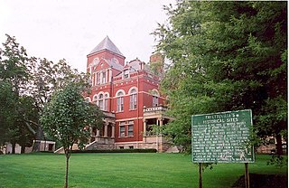
Fayetteville is a town in and the county seat of Fayette County, West Virginia, United States. The population was 2,887 at the 2020 census.

<span class="mw-page-title-main">Gauley Bridge, West Virginia</span> Town in West Virginia, United States

Gauley Bridge is a town in Fayette County, West Virginia, United States. The population was 614 at the 2010 census. The Kanawha River is formed at Gauley Bridge by the confluence of the New and Gauley Rivers. Two miles to the southwest of Gauley Bridge, in Glen Ferris, is Kanawha Falls, a popular stopping point on Midland Trail Scenic Highway.

<span class="mw-page-title-main">Thurmond, West Virginia</span> Town in West Virginia, United States

Thurmond is a town in Fayette County, West Virginia, United States, on the New River. The population was five at the 2020 census. During the heyday of coal mining in the New River Gorge, Thurmond was a prosperous town with a number of businesses and facilities for the Chesapeake and Ohio Railway.

<span class="mw-page-title-main">New Cumberland, West Virginia</span> City in West Virginia, United States

New Cumberland is a city in and the county seat of Hancock County, West Virginia, United States, along the Ohio River. The population was 1,020 as of the 2020 census. It is part of the Weirton–Steubenville metropolitan area and is located near the Mountaineer Casino, Racetrack and Resort.

<span class="mw-page-title-main">Dunbar, West Virginia</span> City in West Virginia, United States

Dunbar is a city in Kanawha County, West Virginia, United States, situated along the Kanawha River. The population was 7,479 at the 2020 census.

<span class="mw-page-title-main">Mason, West Virginia</span> Town in West Virginia, United States

Mason, also known as Mason City, is a town in Mason County, West Virginia, United States. The population was 865 at the 2020 census. It is part of the Point Pleasant, WV–OH Micropolitan Statistical Area.

<span class="mw-page-title-main">Oakvale, West Virginia</span> Town in West Virginia, United States

Oakvale is a town in Mercer County, West Virginia, United States, along the East River. The population was 137 at the 2020 census. It is part of the Bluefield, WV-VA micropolitan area which has a population of 107,578.

<span class="mw-page-title-main">Durbin, West Virginia</span> Town in West Virginia, United States

Durbin is a town in Pocahontas County, West Virginia, United States. The population was 235 at the 2020 census.

<span class="mw-page-title-main">Hinton, West Virginia</span> City in West Virginia, United States

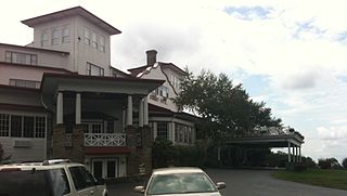
Hinton is a city in and the county seat of Summers County, West Virginia, United States. The population was 2,266 at the 2020 census. Hinton was established in 1873 and chartered in 1897. Hinton was named after John "Jack" Hinton, the original owner of the town site. Much of Hinton's downtown was placed on the National Register of Historic Places in 1984. In 1994, part of Paramount's film Lassie was shot in Hinton. In the 1990s, Hinton's downtown experienced economic decline after a hospital moved away and Interstate 64 bypassed the town. In 2007, Hinton native and business owner Ken Allman founded MountainPlex Properties, which since then has worked to preserve and revitalize the Hinton Historic District.

<span class="mw-page-title-main">Montgomery, West Virginia</span> City in West Virginia

Montgomery is a city in West Virginia, United States, along the Kanawha River. Most of the city is in Fayette County, with the remainder in Kanawha County. The population was 1,280 at the 2020 census.

<span class="mw-page-title-main">Smithers, West Virginia</span> Place in West Virginia, United States

Smithers is a city in Fayette and Kanawha counties in the U.S. state of West Virginia. Located along the Kanawha River, it lies almost entirely in Fayette County. The population was 751 at the 2020 census. The city most likely takes its name from Smithers Creek. The small river city is noted for having a rich cultural history related to both its coal mining and Italian-American heritages.

References

  1. "2019 U.S. Gazetteer Files". United States Census Bureau. Retrieved August 7, 2020.
  2. 1 2 "U.S. Census website". United States Census Bureau . Retrieved January 24, 2013.
  3. 1 2 "U.S. Census website". United States Census Bureau . Retrieved January 31, 2008.
  4. "US Board on Geographic Names". United States Geological Survey. October 25, 2007. Retrieved January 31, 2008.
  5. Columbia-Lippincott Gazetteer. p. 1359
  6. Kenny, Hamill (1945). West Virginia Place Names: Their Origin and Meaning, Including the Nomenclature of the Streams and Mountains. Piedmont, WV: The Place Name Press. p. 451.
  7. "Oak Hill, WV: Fayette County, West Virginia". www.newriverwv.com. Retrieved April 6, 2018.
  8. tyler (March 25, 2016). "Country legend Hank Williams recalled in Oak Hill". West Virginia Press Association. Retrieved July 14, 2022.
  9. "US Gazetteer files: 2010, 2000, and 1990". United States Census Bureau. February 12, 2011. Retrieved April 23, 2011.
  10. "US Gazetteer files 2010". United States Census Bureau. Archived from the original on January 12, 2012. Retrieved January 24, 2013.
  11. "NOWData - NOAA Online Weather Data". National Oceanic and Atmospheric Administration . Retrieved June 12, 2021.
  12. "Summary of Monthly Normals 1991-2020". National Oceanic and Atmospheric Administration . Retrieved June 12, 2021.
  13. "Station: Oak Hill, WV". U.S. Monthly Climate Normals (1981–2010). National Oceanic and Atmospheric Administration. Retrieved June 13, 2021.
  14. "Census of Population and Housing". Census.gov. Retrieved June 4, 2015.
  15. "Gov. Justice debuts Capitol Circle as newest route of West Virginia's Mountain Rides program". governor.wv.gov. Retrieved July 14, 2022.
  16. "Oak Hill City Council - Oak Hill West Virginia". City of Oak Hill. Retrieved July 26, 2023.
  17. "City Manager & Administrative Staff - Oak Hill West Virginia" . Retrieved July 26, 2023.