West Liberty, West Virginia

Last updated

West Liberty, West Virginia
Main Hall, the administration building at West Liberty University, a public university in the West Liberty, West Virginia. The school is West Virginia's oldest institution of higher education LCCN2015632057.tif
Ohio County West Virginia Incorporated and Unincorporated areas West Liberty Highlighted.svg
Location of West Liberty in Ohio County, West Virginia.
Coordinates: 40°9′56″N80°35′41″W / 40.16556°N 80.59472°W / 40.16556; -80.59472
Country United States
State West Virginia
County Ohio
Area
[1]
  Total1.09 sq mi (2.83 km2)
  Land1.09 sq mi (2.83 km2)
  Water0.00 sq mi (0.00 km2)
Elevation
1,224 ft (373 m)
Population
 (2020) [2]
  Total1,557
  Estimate 
(2021) [2]
1,548
  Density1,325.09/sq mi (511.77/km2)
Time zone UTC-5 (Eastern (EST))
  Summer (DST) UTC-4 (EDT)
ZIP code
26074
Area code 304
FIPS code 54-85876 [3]
GNIS feature ID1555947 [4]

West Liberty is a town in Ohio County, West Virginia, United States. The population was 1,557 at the 2020 census. [2] It is part of the Wheeling metropolitan area.

Contents

History

West Liberty was given its name during the American Revolution. [5] [6] It served as the county seat of Ohio County, Virginia from 1777 to 1797.

Geography

West Liberty is located at 40°9′56″N80°35′41″W / 40.16556°N 80.59472°W / 40.16556; -80.59472 (40.165495, −80.594656). [7]

According to the United States Census Bureau, the town has a total area of 0.68 square miles (1.76 km2), all land. [8]

Demographics

Historical population
CensusPop.Note
1850 219
1860 28027.9%
1870 251−10.4%
1880 2697.2%
1980 744
1990 1,43492.7%
2000 1,220−14.9%
2010 1,54226.4%
2020 1,157−25.0%
2021 (est.)1,548 [2] 33.8%
U.S. Decennial Census [9]

2010 census

At the 2010 census there were 1,542 people, 243 households, and 119 families living in the town. The population density was 2,267.6 inhabitants per square mile (875.5/km2). There were 263 housing units at an average density of 386.8 per square mile (149.3/km2). The racial makeup of the town was 94.3% White, 3.2% African American, 0.3% Asian, 0.1% from other races, and 2.0% from two or more races. Hispanic or Latino of any race were 1.2%. [10]

Of the 243 households 18.1% had children under the age of 18 living with them, 34.6% were married couples living together, 7.4% had a female householder with no husband present, 7.0% had a male householder with no wife present, and 51.0% were non-families. 27.2% of households were one person and 9.5% were one person aged 65 or older. The average household size was 2.23 and the average family size was 2.85.

The median age in the town was 20.9 years. 5% of residents were under the age of 18; 73.2% were between the ages of 18 and 24; 8.2% were from 25 to 44; 9.2% were from 45 to 64; and 4.2% were 65 or older. The gender makeup of the town was 43.3% male and 56.7% female.

2000 census

At the 2000 census there were 1,220 people, 241 households, and 120 families living in the town. The population density was 1,865.9 inhabitants per square mile (724.7/km2). There were 285 housing units at an average density of 435.9 per square mile (169.3/km2). The racial makeup of the town was 96.64% White, 1.89% African American, 0.08% Native American, 0.33% Asian, 0.33% from other races, and 0.74% from two or more races. Hispanic or Latino of any race were 0.74%. [3]

Of the 241 households 15.8% had children under the age of 18 living with them, 39.4% were married couples living together, 5.8% had a female householder with no husband present, and 50.2% were non-families. 26.1% of households were one person and 5.8% were one person aged 65 or older. The average household size was 2.29 and the average family size was 2.93.

The age distribution was 6.7% under the age of 18, 70.0% from 18 to 24, 10.9% from 25 to 44, 8.2% from 45 to 64, and 4.2% 65 or older. The median age was 21 years. For every 100 females there were 103.0 males. For every 100 females age 18 and over, there were 101.4 males.

The median household income was $28,393 and the median family income was $38,125. Males had a median income of $18,750 versus $19,375 for females. The per capita income for the town was $7,573. About 13.3% of families and 29.0% of the population were below the poverty line, including 8.2% of those under age 18 and 15.7% of those age 65 or over.

Education

West Liberty is the site of West Liberty University. [11]

Notable person

Related Research Articles

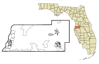
Springfield is a city in Bay County, Florida, United States, east of Panama City. It is part of the Panama City–Lynn Haven–Panama City Beach Metropolitan Statistical Area. Springfield was incorporated on February 12, 1935. The population was 8,075 at the 2020 census.

<span class="mw-page-title-main">Zephyrhills North, Florida</span> CDP in Florida, United States

Zephyrhills North is a census-designated place (CDP) in Pasco County, Florida, United States. The population was 2,544 at the 2000 census.

<span class="mw-page-title-main">Liberty, Indiana</span> Town in Indiana, United States

Liberty is a town in and the county seat of Union County, Indiana, United States, located about 5 miles (8.0 km) west of the state's border with Ohio. The population was 2,000 at the 2020 census.

<span class="mw-page-title-main">Ellsworth, Michigan</span> Village in Michigan, United States

Ellsworth is a village in Antrim County in the U.S. state of Michigan. The population was 367 at the 2020 census. The village is located within Banks Township.

<span class="mw-page-title-main">Foster, Missouri</span> Village in Missouri, United States

Foster is a village in Bates County, Missouri, and part of the Kansas City metropolitan area within the United States. The population was 76 at the 2020 census.

<span class="mw-page-title-main">Liberty, Missouri</span> City in Missouri, United States

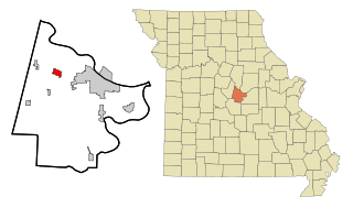
Liberty is a city in and the county seat of Clay County, Missouri, United States and is a suburb of Kansas City, located in the Kansas City Metropolitan Area. As of the 2020 United States Census the population was 30,167. Liberty is home to William Jewell College.

<span class="mw-page-title-main">St. Martins, Missouri</span> City in Missouri, United States

St. Martins or Saint Martins is a city in Cole County, Missouri, United States. The population was 1,191 at the 2020 census. It is part of the Jefferson City, Missouri Metropolitan Statistical Area.

<span class="mw-page-title-main">Liberty, Nebraska</span> Village in Nebraska, United States

Liberty is a village in Gage County, Nebraska, United States. The population was 37 at the 2020 census.

<span class="mw-page-title-main">Lena, Mississippi</span> Town in Mississippi, United States

Lena is a town in Leake County, Mississippi, United States. The population was 148 at the 2010 census. The center of population of Mississippi is located in Lena.

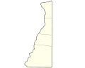
Dix is a town in Schuyler County, New York, United States. The population was 3,723 at the 2020 census.

<span class="mw-page-title-main">Worthington, West Virginia</span> Town in West Virginia, United States

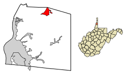
Worthington is a town in Marion County, West Virginia, United States. The population was 158 at the 2010 census. Worthington was incorporated in 1893 and named for Colonel George Worthington, an early settler. U.S. Route 19 passes through the town.

<span class="mw-page-title-main">Albright, West Virginia</span> Town in West Virginia, United States

Albright is a town in central Preston County, West Virginia, United States, along the Cheat River. The population was 260 at the 2020 census. A former coal town, it is part of the Morgantown metropolitan area.

<span class="mw-page-title-main">Bancroft, West Virginia</span> Town in West Virginia, United States

Bancroft is a town in Putnam County, West Virginia, United States, along the Kanawha River. The population was 389 at the 2020 census. It is part of the Huntington–Ashland metropolitan area.

<span class="mw-page-title-main">Lester, West Virginia</span> Town in West Virginia, United States

Lester is a town in Raleigh County, West Virginia, United States. The population was 337 at the 2020 census. The community was named after Champ Lester, a local pioneer.

<span class="mw-page-title-main">Sophia, West Virginia</span> Town in West Virginia, United States

Sophia is a town in Raleigh County, West Virginia, United States. It was incorporated in 1912. The population was 1,124 at the 2020 census.

<span class="mw-page-title-main">Reedy, West Virginia</span> Town in West Virginia, United States

Reedy is a town in Roane County, West Virginia, United States. The population was 152 at the 2020 census.

<span class="mw-page-title-main">Fort Gay, West Virginia</span> Town in West Virginia, United States

Fort Gay is a town in Wayne County, West Virginia, United States, situated along the Tug Fork and Big Sandy rivers. The town adjoins Louisa, Kentucky. The population was 677 at the 2020 census.

<span class="mw-page-title-main">Camden-on-Gauley, West Virginia</span> Town in West Virginia, United States

Camden-on-Gauley is a town in Webster County, West Virginia, United States, along the Gauley River. The population was 126 at the 2020 census.

<span class="mw-page-title-main">Pine Grove, West Virginia</span> Town in West Virginia, United States

Pine Grove is a town in Wetzel County, West Virginia, United States. The population was 363 at the 2020 census. The community was named for a grove of pine trees near the original town site.

<span class="mw-page-title-main">North Hills, West Virginia</span> Town in West Virginia, United States

North Hills is a town in Wood County, West Virginia, United States. It is a suburb of Parkersburg. The population was 837 at the 2020 census. North Hills was incorporated on February 15, 1979.

References

  1. "2019 U.S. Gazetteer Files". United States Census Bureau. Retrieved August 7, 2020.
  2. 1 2 3 4 "City and Town Population Totals: 2020-2021". Census.gov. US Census Bureau. Retrieved July 2, 2022.
  3. 1 2 "U.S. Census website". United States Census Bureau . Retrieved January 31, 2008.
  4. "US Board on Geographic Names". United States Geological Survey. October 25, 2007. Retrieved January 31, 2008.
  5. Capace, Nancy (1999). Encyclopedia of West Virginia. North American Book Dist LLC. p. 197. ISBN   978-0-403-09843-9.
  6. Kenny, Hamill (1945). West Virginia Place Names: Their Origin and Meaning, Including the Nomenclature of the Streams and Mountains. Piedmont, WV: The Place Name Press. p. 667.
  7. "US Gazetteer files: 2010, 2000, and 1990". United States Census Bureau. February 12, 2011. Retrieved April 23, 2011.
  8. "US Gazetteer files 2010". United States Census Bureau . Retrieved January 24, 2013.
  9. "Census of Population and Housing". Census.gov. Retrieved June 4, 2015.
  10. "U.S. Census website". United States Census Bureau . Retrieved January 24, 2013.
  11. "West Liberty University". West Liberty University. Retrieved August 24, 2012.